1. Land Use Change and Current Forest Structure at Howard
Falls Land Trust in Northwestern Pennsylvania
Nicholas Baldwin, Ottavio Borgia, Ryan Hnida, Richard Kirby, Melissa Normandeau, Thomas
Norway, Andrea Pace, Alyssa Piper, Michael Ritner, Philip Schreiber, Allison Swan, and
Karen S. Eisenhart (Edinboro University, Dept. of Geosciences)
Abstract It is well known that Pennsylvania experienced a dramatic change in land use from agriculture to forest cover during
the twentieth century. The purpose of this research project was to determine and analyze the change in land use on the Howard
Falls Land Trust property in Erie County, Pennsylvania. We used aerial photographs from 1939, 1959, 1969 and 1992 along with
tree cores to estimate the minimum age of forest patches. We subsampled the stand structure of seven plots that are currently
forested, and collected tree cores from the largest trees in 5 of the 7 plots for age determination. The property experienced
dramatic changes in land use between 1939 and 1992. In 1939, 43% of the land trust area was cultivated and 23% was forested.
By 1992, 63% was forested and only 17% was cultivated. We identified forest patches that ranged in age from at least 25 years old
to more than 75 years. Considering all seven field plots, tree species richness was 10 (for DBH > 10cm); however, like other
studies of post-agriculture landscapes in the eastern U.S., Acer rubrum (red maple) dominated the tree density and basal area in
all sampled plots. Few studies of this type have been conducted in Northwest Pennsylvania and this project is the first in Erie
County. Our study suggests the Howard Falls Land Trust property is typical for the eastern deciduous forest region.
1992196919591939
2005 color orthophoto
Objectives:
•Use air photos and tree cores to estimate time-since-agricultural-abandonment of
landscape patches in the Howard Falls landscape.
•Collect tree data to characterize patch structure of select plots.
•Determine diameter-frequency distribution of each plot.
Study site:
The study site (Map 1) is located in Erie County, Pennsylvania at Howard Falls Land Trust. The
site is relatively flat and features a gorge on the western extent of the property. Geographically, it
falls in the transition between Hemlock-white pine-northern hardwoods and Beech-maple forests
as described by Braun (Delcourt & Delcourt, 2000). The region was previously glaciated leaving
behind poorly-drained glacial tills, primarily Mill silt loam and Venango silt loam. The climate
region is humid continental, with annual precipitation ranging from 94 cm to 109 cm and
experiences lake effect snow throughout the winter (Soil Survey, 2013).
Field Sampling:
Each sampled plot was 50 m x
8 m. All trees in the plot that
were 2.5 cm diameter or larger
were recorded individually by
species and diameter.
Forest Species Richness and Dominance:
•Considering all plots, tree species richness was 10: Acer rubrum (red maple), Fraxinus americana (white
ash), Prunus serotina (black cherry), Acer saccharum (sugar maple), Nyssa sylvatica (black gum),
Amelanchier arborea (service berry), Quercus rubra (red oak), Fagus grandifolia (American beech),
Populus tremuloides (trembling aspen), and Magnolia acuminata (cucumber magnolia).
•Acer rubrum dominated both tree density and basal area in all plots. Fraxinus americana is the second
most abundant tree species, but occurs only in the younger sites (Figure 1).
•Average basal area for the plots is 35 m2
/ha and average tree density is .12/m2
(Figure1).
References:
Abrams, M. D. (1998). The Red Maple Paradox. BioScience 48: 355-364.
Delcourt, H. R., & Delcourt, P. A. (2000). Eastern Deciduous Forests. In Barbour & Billings, North American Terrestrial Vegetation (pp. 358-382).
Dyer, J. M. (2009). Land-Use Legacies in a Central Appalachian Forest: Differential Response of Trees and Herbs to Historic Agricultural Practices. Applied Vegetation Science 13:195-206.
Whitney, G. G., & DeCant, J. P. (2003). Physical and Historical Determinants of the Pre-and Post-Settlement Forests of Northwestern Pennsylvania. Canadian Journal of Forest Research 33: 1683-1697.
Soil Survey Erie County Pennsylvania. (1960). Series 1957, No. 9, United States Department of Agriculture. Archived at www.nrcs.usda.gov.
Web Soil Survey. (2013). Web Soil Survey, Natural Resources Conservation Service. Retrieved from websoilsurvey.sc.egov.usda.gov.
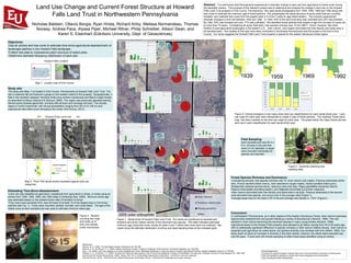
Figure 1. Aerial photo of Howard Falls Land Trust. Pie charts are positioned at sampled plot
locations and show relative density of the dominant tree species. Plot label indicates estimated
minimum age using tree cores, except for plots 4 and 7 where tree cores were not collected. Bar
charts show the diameter distribution of all live and dead standing trees at the indicated plots.
Map 2. Penn Pilot aerial photos illustrated against land use
categories.
Plot 1
Min Age
45
Plot 1
Min Age
45
Plot 2
Min Age
52
Plot 2
Min Age
52
Plot 3
Min Age
50
Plot 3
Min Age
50
Plot 4
Min Age
55
(Air Photo Estimate)
Plot 4
Min Age
55
(Air Photo Estimate)
Plot 5
Min Age
50
Plot 5
Min Age
50
Plot 6
Min Age
65
Plot 6
Min Age
65
Plot 7
Min Age
55
(Air Photo Estimate)
Plot 7
Min Age
55
(Air Photo Estimate)
Estimating Time-Since-Abandonment:
•Land use was classified as agriculture, transitional from agriculture to forest, or forest using air
photos from 1939, 1959, 1969, and 1992 (Map 2) (following Dyer, 2009). Minimum forest age
was estimated based on the earliest known date of transition to forest.
•Tree cores were extracted from near the base of at least 10 of the largest trees in five forest
patches (see Fig. 1). Cores were mounted, sanded, counted, and cross-dated. The age of the
oldest cores at each sampled plot was used to estimate minimum stand age.
Figure 2. Colored polygons in top maps show land use classifications for each aerial photo year. Land
use maps for each year were intersected to create a map of forest patches. The resulting forest patch
map has been overlaid on the land use maps for each year. The graph below the maps shows percent
land use in each classification for each aerial photo year.
Conclusion:
In northwestern Pennsylvania, as in other regions of the Eastern Deciduous Forest, Acer rubrum expresses
opportunistic establishment and growth following a variety of disturbances (Abrams, 1998). This has
resulted in Acer rubrum becoming the dominant species in many young forests (Abrams, 1998).
Agricultural areas on the Howard Falls property were allowed to go fallow varying from 44 to 63 years ago,
with no statistically significant difference in species richness or Acer rubrum relative density. Acer rubrum is
expected post-agriculture as noted above, but species diversity may increase with time (Hibbs, 1983). Our
study does not show an increase in diversity in the older stands, however, the oldest stand sampled was
only 65 years. Future work will include sampling of older forest areas identified using air photos.
Figure 3. Student
counting tree rings
and close up of
tree core sample
under microscope
Figure 4. Students collecting tree
seedling data.
Howard Falls Location
Map 1. Locator map of Erie County
Acknowledgements:
Funding and Logistical Support: Howard Falls Land Trust and Edinboro University of Geosciences;
Field Lab Assistance: Students in GEOG 525 Forest Geography and Conservation;
Tree Core Mounts: Mark Wickenheiser