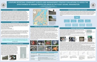
1. Management
Strategy
Context
What factors were taken into
consideration prior to MPA
designation?
Example Indicator
A resource inventory was
conducted prior to
designation
Planning
Documents and legislative
tools for MPA
implementation
Example Indicator
MPA boundaries are properly
demarcated
Inputs
Resources used to
implement management
Example Indicator
Level of patrol staff is
sufficient to enforce laws and
regulations
Process
Procedures and methods
used to manage the area
Example Indicator
Educational material is
accessible to the public
COUPLING INTERTIDAL COMMUNITY SURVEYS AND MANAGEMENT STRATEGY EVALUATIONS TO ASSESS THE
EFFECTIVENESS OF MARINE PROTECTED AREAS IN THE PUGET SOUND, WASHINGTON
Erin Dilworth, Master of Science Candidate
Central Washington University, Resource Management Graduate Program
eedilworth@gmail.com
ABSTRACT
Intertidal community response to Marine Protected Area (MPA) designation and related
management strategies in the Puget Sound, WA was explored. Intertidal communities displayed
variable responses to protection, and were similar between protected and non-protected sites,
suggesting MPA designation does not contribute to increased abundance of intertidal species. Only
two species (Pacific blue mussel and red velvet mite) occurred more frequently at MPA sites than
control sites. Invertebrate diversity at low tidal heights responded positively to MPA designation, and
correlated positively with well developed management strategies. Vegetation diversity was similar
between MPAs and control sites, and was negatively correlated with well developed management
strategies. These results suggest that MPA designation is useful for increasing abundance of intertidal
invertebrates at low tidal heights, which can be further enhanced by comprehensive management.
The lack of biological response to most management components suggests that these communities
may need more managerial attention before differences can be detected inside protected areas.
Do MPAs maintain or enhance intertidal biodiversity within their
boundaries, and what roles do protection level and management
strategy play?
INTRODUCTION
Washington State is home to 127 aquatic and terrestrial reserves known as Marine Protected
Areas, totaling roughly 644,000 acres and 1,136 miles of shoreline. The term “Marine Protected Area”
has been active in the management landscape since the early 1990s as a means of networking and
coordinating the design and implementation of protected areas. Many protected area designations
are included in Washington’s system of MPAs:
•National, state and city parks
•Marine sanctuaries and wildlife refuges
•Conservation areas and marine preserves, etc.
The widespread approval and implementation of MPAs has been hindered as their applicability as
an effective management instrument has been questioned due to the lack of a single program-wide
design or coordination scheme across the 12 diverse managing agencies in the state. Common
discrepancies include dissimilar or mismatched objectives, site selection criteria, implementation
design, funding, protection level designation and monitoring practices.
The MPA Work Group has identified data gaps in coordination and consistency, and has called for
performance evaluations of existing MPAs to determine if they provide enough ecosystem protection
and if the various levels of protection provided are proficient in achieving their management goals.
PUGET SOUND INTERTIDAL COMMUNITY
MANAGEMENT STRATEGY EVALUATION
INTERTIDAL COMMUNITY SURVEY
A quantitative evaluation of the management policies and practices in place at each MPA surveyed was completed through
combination of review and evaluation of management documents, observations of management practices made during field visits,
and interviews with site managers. Indicators, or criteria used to assess the condition of a system, are widely used to evaluate and
quantitatively score management policies and practices. Indicators were chosen to evaluate four components of management:
context, planning, inputs, and processes. Evidence used to evaluate each indicator was scored as considerable, moderate or
negligible.
The Puget Sound estuary is located between the Olympic Mountains to the west, and the Cascade
Mountains to the east. The entire Puget Sound watershed covers 17,000 square miles, with
approximately 2,800 square miles of that area being comprised of passages, deep channels, inlets,
bays, and 52 islands. Puget Sound was formed via glacial carving of glacial and interglacial sediments
about 10,000 to 14,000 years ago. This carving created the deep and narrow channels, islands, and
peninsulas that can be seen within the Sound today.
The Puget Sound basin is home to over 200 species of fish, approximately 7,000 species of marine
invertebrates, 625 species of marine algae, six species of seagrass, hundreds of species of
phytoplankton, and 26 species of marine mammals. This diverse mix of life is being threatened by
multiple human-induced shoreline modifications such as diking, dredging, armoring, extraction, and
deforestation. As of 2006, 64 species have been listed as a “species of concern”, growing from 60 in
2002. Many of these species rely on nearshore environments, suggesting that declines are at least in
part due to changes in nearshore ecosystems. Intertidal communities are heavily impacted by
commercial and recreational harvest, and non-consumptive losses due to collecting, trampling and
rock turning, among others.
Sampling occurred at extreme low tide events during the summer of 2010. Sites were selected to
control for substrate, fetch, age and level of protection. Three Uniform Multiple Use, three Zoned
Multiple Use, and three No Take MPAs, plus nine adjacent
control sites were surveyed. Following methods outlined by
Island County/WSU Beachwatchers, one transect was placed
perpendicular to the water’s edge, from the backshore to the
predicted lowest tidal height in reference to the Mean Lower
Low Water (MLLW) for that day. Within 10 feet of either side
of the transect line, the presence or absence of intertidal
organisms was recorded down to the lowest taxonomic level
possible. Three transects were placed parallel to the water’s
edge at each site, and were set at the +1, 0, and -1 foot tidal
heights in reference to the MLLW for that day.
Belt transect survey method. WSU/Island Co. Beach Watchers
performing quadrat survey.
Sample intertidal community survey layout.
Left: Map of 18 study sites Top: Emma
Schmitz Memorial Marine Preserve in
Seattle. Bottom: Colvos Passage Marine
Preserve in Gig Harbor. Pictures are
illustrative of mismatched siting criteria
and environmental conditions
Protection Level Description
Uniform Multiple-Use (UML) Uniform level of protection while allowing some extractive activities.
Zoned Multiple-Use (ZML) Allow some extractive activities, but only in certain zones and at certain times of
the year.
Zoned Multiple-Use with No
Take Area(s) (ZNL)
Allow some extractive activities and contain at least one no take zone.
No Take (NTL) Allow human access and some potentially detrimental activities, but does not
allow resource extraction in any capacity.
No Impact (NIL) Allow human access but prohibit all potentially harmful activities.
No Access (NAL) Ban all human access, unless specially permitted for monitoring, restoration, or
research.
Blood star
(Henricia leviuscula) Acorn barnacle (Balanus glandula) Red rock crab (Cancer productus) Lewis’ moonsnail (Euspira lewisii)
Purple sea star
(Pisaster ochraceus)
Pacific plate limpet
(Lottia scutum)
Mossy chiton
(Mopalia muscosa)Goose barnacle (Pollicipes polymerus)
Green sea anemone
(Anthopluera xanthogrammica)
RESULTS AND DISCUSSION
• Intertidal community composition is similar between MPA and control sites, and do not
become less similar with increased protection indicating that higher levels of protection do
not necessarily enhance intertidal community richness.
•Pacific blue mussel, red velvet mite, aggregating anemone and dogwinkle snails show
significant response to level of protection, and in only one case (Pacific blue mussel) did NTL
sites outrank ZNL sites, again suggesting that higher levels of protection do not necessarily
enhance individual species’ abundance.
•Pacific blue mussel and red velvet mite also showed significantly higher proportions at MPAs
than at control sites.
•Invertebrate diversity was found to be significantly higher at the -1’ tidal height quadrats of MPAs than control sites, and was
positively correlated with well-developed planning strategies and with highly scoring management regimes as a whole (average of
context, planning, inputs and process scores). Invertebrate diversity at the 0’ tidal height was negatively correlated with poorly
developed planning strategies and positively correlated with total management.
•Vegetation diversity at the -1 foot tidal heights was negatively correlated with highly scoring management regimes - those with
more developed planning strategies especially – and positively correlated to underdeveloped planning strategies.
•No significant correlation was found between similarity coefficients and management scores. One would expect that site pairings
of low similarity (i.e., MPA and control site do not have similar intertidal communities) would correlate with high management
scores. Lack of such findings suggests that intertidal communities do not respond to management strategies in any right, and
may be more a function of environmental conditions or other variables not studied here. This conclusion is further supported by
the fact that there was no correlation between any intertidal community parameter and management context, inputs or process.
0
10
20
30
40
50
60
70
80
90
100
PercentageSimilarity
Sorenson Coefficient
Coefficient of Community
Percent Similarity
Level of Protection
0.00
0.10
0.20
0.30
0.40
0.50
0.60
0.70
0.80
0.90
0.00 10.00 20.00 30.00 40.00 50.00 60.00
Simpson'sInvertebrateDiversity
Index
Planning Scores - % Considerable
0.00
0.10
0.20
0.30
0.40
0.50
0.60
0.70
0.80
0.00 20.00 40.00 60.00 80.00 100.00
Simpson'sInvertebrateDiversity
Index
Planning Scores - % Negligible
0.00
0.10
0.20
0.30
0.40
0.50
0.60
0.70
0.80
0.90
0.00 5.00 10.00 15.00 20.00 25.00 30.00 35.00
Simpson'sInvertebrateDiversityIndex
Average Management Scores - % Considerable
0'
-1'
0.00
0.05
0.10
0.15
0.20
0.25
0.30
0.35
0.40
0.45
0.00 5.00 10.00 15.00 20.00 25.00 30.00 35.00
Simpson'sVegetationDiversity
Index
Average Management Scores - % Considerable
Red velvet
mite
(Neomolgus
littoralis)
Pacific blue
mussel
(Mytilus
trossulus)
Aggregating
anemone
(Anthopleura
elegantissima)
Dogwinkle
snails (Nucella
spp.)
Invertebrate diversity at the 0 and -1
foot tidal heights correlation with
proportion of site average
management scores evaluated at
“considerable”, p = 0.0584 and P =
0.0756, respectively.
Invertebrate diversity at the -1’ tidal height
correlation with proportion of site planning
scores evaluated as “considerable”, p =
0.0441.
Invertebrate diversity at the 0’ tidal
height correlation with proportion of site
planning scores evaluated as “negligible”.
p = 0.0853.
Vegetation diversity at the -1’ tidal heights
correlation with proportion of total average
management score evaluated as
“considerable”, p = 0.0756.
Mary Jo Adams
Mary Jo Adams
Dave Ingram
2. MANAGEMENT RECOMMENDATIONS
1) The MPAs studied here only addressed a few potential causes of negative impacts to intertidal
communities (i.e. only harvest was restricted in these MPAs). Human trampling has proven to be a
limiting factor for intertidal populations, consequently, a habitat-focused approach to marine
conservation may be more effective than harvest regulations.
2) Enhanced knowledge and understanding of intertidal population dynamics in order to more
appropriately site and design MPAs for population replenishment considerations. Some of the MPAs
used in this study may have been too small to facilitate benthic population replenishment or to
protect intertidal communities from external stressors such as pollution.
3) Zoned-multiple Use MPAs often showed higher abundances of some organisms than No Take
Reserves - consider implementing more ZNL MPAs, given the uncertainty of the effectiveness of no-
take reserves and the potentially lower financial and administrative costs of ZNLs versus NTLs.
4) Approach further MPA establishment with caution: the results of this study coupled with a lack of
unambiguous data from the scientific community surrounding the effectiveness of MPAs in general
may lead to artificially high expectations of managers and the public, and may lead to an
abandonment of MPA establishment if outcomes continue to be variable.
CONCLUSIONS
The goal of this study was to determine the effectiveness of MPAs in the Puget Sound by evaluating
intertidal communities and the management strategies which oversee their protection. Intertidal
communities showed variable responses to MPA designation, with only a few individual species (i.e.,
Pacific blue mussel and red velvet mite) showing higher abundances in MPAs versus unprotected
control sites. Invertebrate diversity in low elevation areas showed a positive response to MPA
protection, and positively correlated with well-developed management strategies. However, intertidal
communities as a whole were similar between protected and non-protected sites. These communities
showed no correlation with management inputs and processes, indicating that variable environmental
conditions or other external stressors may play a bigger role in shaping intertidal community
structure. Low elevation invertebrate communities did positively correlate with increased efforts in
planning, suggesting that a well-developed management plan is key to protecting invertebrate
diversity.
Given the variability of documented MPA research and the results of this study, some further
research is warranted in order to address some of these management recommendations and the
ambiguity surrounding MPA efficacy in the Puget Sound:
1) Do sites that address all causes of intertidal disturbance (i.e., No Access MPAs) have healthier
intertidal communities?
2) How do external stressors (e.g., chemical contamination, conflicting landuses, etc.) affect intertidal
communities?
3) What are the habitat requirements for reproduction, migration and juvenile rearing for intertidal
populations, especially those keystone species which help shape intertidal community
composition?
ACKNOWLEDGEMENTS
Thank you to the CWU Faculty Development and Research Committee for providing funding to
complete this research. Thanks to Amanda Johnston and Jeff Malone for help in surveying intertidal
communities, and Tommy Wachholder for GIS help. Thanks to my advisor, Dr. Anthony Gabriel, for
continued help in developing this research. Lastly, thank you to my friends and family who have
supported me throughout my entire academic career.
REFERENCES
Agardy, T., Bridgewater, P., Crosby, M.P., Day, J., Dayton, P.K., Kenchington, R. et al. (2003). Dangerous targets? Unresolved issues and
ideological clashes around marine protected areas. Aquatic Conservation: Marine and Freshwater Ecosystems, 13, 353-367.
Allison, G.W., Lubchenco, J. & Carr, M.H. (1998). Marine reserves are necessary but not sufficient for marine conservation. Ecological
Applications, 8(1) Supplement, S79-S92.
Carney, D. & Kvitek, R.G. (1991). Assessment of nongame marine invertebrate harvest in Washington. Olympia, WA: Washington Department of
Fish and Wildlife.
Dethier, M.N., Duggins, D.O. & Mumford, T.F. Jr. (1989). Harvesting of non-traditional marine resources in Washington State: Trends and
concerns. The Northwest Environmental Journal, 5, 71-87.
Ervin, J. (2003). WWF Rapid Assessment and Prioritization of Protected Area Management (RAPPAM) Methodology. Gland, Switzerland: WWF.
Hockings, M., Stolton, S., Leverington, F., Dudley, N., & Courrau, J. (2006). Evaluating effectiveness: a framework for assessing management
effectiveness of protected areas, 2nd edition. IUCN, Gland, Switzerland and Cambridge, UK. xiv + 105 pp.
Island County/WSU Beach Watchers. (2003). Training manual for Island County/Washington State University Beach Watchers: Beach
monitoring procedures. Coupeville, WA: Author.
Murray, M.R. & Fergeson, L. (1998). The Status of Marine Protected Areas in Puget Sound. Proceedings of the 1998 Puget Sound Georgia Basin
Research Conference, Seattle, WA.
Pomeroy, R.S., Parks, J.E., & Watson, L.M. (2004). How is your MPA doing? A guidebook of natural and social indicators for evaluating marine
protected area management effectiveness. IUCN, Gland, Switzerland and Cambridge, UK. xvi + 216 pp.
Van Cleve, F.B., Bargmann, G., Culver, M., & The MPA Work Group. (2009). Marine Protected Areas in Washington: Recommendations of the
Marine Protected Areas Work Group to the Washington State Legislature. Washington Department of Fish and Wildlife, Olympia, WA.