AHM 2014: BCube Brokering Framework
•Download as PPTX, PDF•
0 likes•361 views

The document discusses a watershed modeling system called BCube that aims to decrease the effort of watershed initialization by brokering various global geospatial and environmental data required for watershed modeling. BCube allows researchers to focus on scientific research by providing a single access point to the different data formats and sources for elevation, soils, land use, weather, and other data needed to set up and run watershed models. The document provides an overview of the types of data BCube can broker and the workflow where a scientist requests data for a watershed area and BCube returns the available options to choose from.

Recommended
Recommended
More Related Content
What's hot
What's hot (20)
Viewers also liked
Viewers also liked (18)
Similar to AHM 2014: BCube Brokering Framework
Similar to AHM 2014: BCube Brokering Framework (20)
More from EarthCube
More from EarthCube (17)
Recently uploaded
Recently uploaded (20)
AHM 2014: BCube Brokering Framework
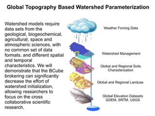
- 1. Global Topography Based Watershed Parameterization Watershed models require data sets from the geological, biogeochemical, agricultural, space and atmospheric sciences, with no common set of data formats, and different spatial and temporal characteristics. We will demonstrate that the BCube brokering can significantly decrease the effort of watershed initialization, allowing researchers to focus on the cross collaborative scientific research. Weather Forcing Data Watershed Management Global and Regional Soils Characterization Global and Regional Landuse Global Elevation Datasets GDEM, SRTM, USGS
- 2. Hydrological/Watershed Modeling Scenario Overview Flow Scientist zooms into area with extents covering watershed Area sent to broker which returns available DEM options Scientist chooses DEM, which the Broker then returns projected and combined DEM Scientist runs through watershed delineation Area is sent to broker to obtain Soils options, Landuse (FAO, NCDC, NASA), historical weather (NCAR, NCDC), and future climate (IPCC) Data Requirements Elevation (GDEM, SRTM, USGS), Soils (FAO, SSURGO), Landuse (FAO, NCDC, NASA), Historical Weather (NCAR, NCDC), Short term forecasts (NWS, NCEP), Future Climatology (IPCC), and Stream Flow (USGS, GRDC) Frosting on the Cake Broker locates additional sources of weather forcing data, stream flow, landuse, or other compatible datasets for corroborating globally relevant watershed models
- 3. Assumptions The Hydrologist thinks the world is as data rich as the experimental fields they have been monitoring The Hydrologist knows nothing about spatial data manipulation The Hydrologist knows nothing about temporal data manipulation The Hydrologist has used a GIS sometime during their life Hydrologists are experts in many different fields, so we must assume each is ignorant in ours
- 4. Needs GIS and standard data access connectors (WCS)
- 5. Global Topography Based Watershed Parameterization Weather Forcing Data Watershed Management Global and Regional Soils Characterization Global and Regional Landuse Global Elevation Datasets GDEM, SRTM, USGS
- 6. First Examples Study 1 – Influence of DEM Source and Resolution on Regional Water Quality Broker provides handles to: USGS 3, 10, 30m DEMs SRTM 90m SRTM 30m ASTER GDEM 30m
- 7. Simple and Quick Comparisons
- 8. Simple and Quick Comparisons
- 9. Global Topography Based Watershed Parameterization Weather Forcing Data Watershed Management Global and Regional Soils Characterization Global and Regional Landuse Global Elevation Datasets GDEM, SRTM, USGS