SlideShare a Scribd company logo
1 of 2
Download to read offline
Bathymetric Lidar and its uses
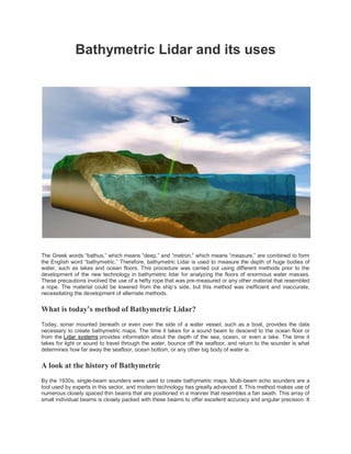
The Greek words “bathus,” which means “deep,” and “metron,” which means “measure,” are combined to form
the English word “bathymetric.” Therefore, bathymetric Lidar is used to measure the depth of huge bodies of
water, such as lakes and ocean floors. This procedure was carried out using different methods prior to the
development of the new technology in bathymetric lidar for analyzing the floors of enormous water masses.
These precautions involved the use of a hefty rope that was pre-measured or any other material that resembled
a rope. The material could be lowered from the ship’s side, but this method was inefficient and inaccurate,
necessitating the development of alternate methods.
What is today’s method of Bathymetric Lidar?
Today, sonar mounted beneath or even over the side of a water vessel, such as a boat, provides the data
necessary to create bathymetric maps. The time it takes for a sound beam to descend to the ocean floor or
from the Lidar systems provides information about the depth of the sea, ocean, or even a lake. The time it
takes for light or sound to travel through the water, bounce off the seafloor, and return to the sounder is what
determines how far away the seafloor, ocean bottom, or any other big body of water is.
A look at the history of Bathymetric
By the 1930s, single-beam sounders were used to create bathymetric maps. Multi-beam echo sounders are a
tool used by experts in this sector, and modern technology has greatly advanced it. This method makes use of
numerous closely spaced thin beams that are positioned in a manner that resembles a fan swath. This array of
small individual beams is closely packed with these beams to offer excellent accuracy and angular precision. It
is clear that a boat can survey more seafloors quickly with a depth-dependent wide swath than with a single
beam echosounder since it requires fewer passes.
Depending on the depth of the water body being worked on, the beams are capable of updating anywhere
between 0.1 and 50 Hz numerous times per second. This relates to boat speed while there is complete seafloor
coverage.
Uses of Bathymetric Lidar
Remote sensing of coastlines is carried out using bathymetric Lidar.
It’s all about monitoring, detecting, and detecting. Even while it can be done in other regions of the world in a
manner similar to this, this practice only applies to the American system. For coastal demarcation, visual
interpretation of data from aerial remote sensing is well-known and frequently used. For monitoring, extracting,
and detecting coastal lines, a variety of methods and remote sensing data are available.
It is employed in both the study of historical landscapes and archaeological research.
This makes use of remote sensing technology. The application of bathymetric lidar in these areas has
transformed archaeology. Researchers in landscape archaeology, often known as the field of settlement, have
taken an interest in light detection and ranging (LiDAR), a remote sensing technique that uses lasers as
topographic scanners capable of piercing foliage. This technology allows for the display of the same
landscapes in ways that were before impractical while also providing extensive data on the terrain for
enormous spatial expanses. The data and visualizations have both been utilized to gain a better understanding
of historical landscapes and how older people used them in the past.
Click Here to continue reading

More Related Content

Similar to Bathymetric Lidar and its uses.pdf

Hidden Depths and Hidden Data
Hidden Depths and Hidden DataHidden Depths and Hidden Data
Hidden Depths and Hidden DataMarc Goossens
 
CE203 -Hydrographic survey.pptx
CE203 -Hydrographic survey.pptxCE203 -Hydrographic survey.pptx
CE203 -Hydrographic survey.pptxAbdulQHannan
 
Exploring the Depths: Applications of Bathymetric Lidar Drones in Marine Rese...
Exploring the Depths: Applications of Bathymetric Lidar Drones in Marine Rese...Exploring the Depths: Applications of Bathymetric Lidar Drones in Marine Rese...
Exploring the Depths: Applications of Bathymetric Lidar Drones in Marine Rese...falconsurveyme
 
Marine Cartography as a Management Tool
Marine Cartography as a Management ToolMarine Cartography as a Management Tool
Marine Cartography as a Management ToolEsri
 
Reconnaissance for Hydrographic Survey Project
Reconnaissance for Hydrographic  Survey ProjectReconnaissance for Hydrographic  Survey Project
Reconnaissance for Hydrographic Survey ProjectNzar Braim
 
OECD_PortugalKeynote_SatelliteTechnology_R1r00
OECD_PortugalKeynote_SatelliteTechnology_R1r00OECD_PortugalKeynote_SatelliteTechnology_R1r00
OECD_PortugalKeynote_SatelliteTechnology_R1r00Keiran Millard
 
UNDER WATER ACOUSTIC COMMUNICATION
UNDER WATER ACOUSTIC COMMUNICATIONUNDER WATER ACOUSTIC COMMUNICATION
UNDER WATER ACOUSTIC COMMUNICATIONjaisica
 
Hydrographic Surveying By Jithin Jose
Hydrographic Surveying  By Jithin JoseHydrographic Surveying  By Jithin Jose
Hydrographic Surveying By Jithin JoseJithin Jose
 
Archaeological and groundwater investigations
Archaeological and groundwater investigationsArchaeological and groundwater investigations
Archaeological and groundwater investigationsZaidoon Taha
 
Running head UNDERWATER EXCAVATION .docx
Running head UNDERWATER EXCAVATION                               .docxRunning head UNDERWATER EXCAVATION                               .docx
Running head UNDERWATER EXCAVATION .docxtodd521
 
Presentation on routing services copy
Presentation  on routing services   copyPresentation  on routing services   copy
Presentation on routing services copydevendra jhajhra
 
Pipeline Depth Of Cover Surveys
Pipeline Depth Of Cover SurveysPipeline Depth Of Cover Surveys
Pipeline Depth Of Cover SurveysSidescan
 
About the paper USC CINAPS Builds Bridges Observing and Monitoring the Southe...
About the paper USC CINAPS Builds Bridges Observing and Monitoring the Southe...About the paper USC CINAPS Builds Bridges Observing and Monitoring the Southe...
About the paper USC CINAPS Builds Bridges Observing and Monitoring the Southe...Giovanni Murru
 
Modern navigational instruments
Modern navigational instrumentsModern navigational instruments
Modern navigational instrumentsGeronimo Rosario
 
Navaids In Aviation Essay
Navaids In Aviation EssayNavaids In Aviation Essay
Navaids In Aviation EssayAshley Lovato
 
DSD-NL 2018 Evolutie in het leveren van ruimtelijke en temporele water gerela...
DSD-NL 2018 Evolutie in het leveren van ruimtelijke en temporele water gerela...DSD-NL 2018 Evolutie in het leveren van ruimtelijke en temporele water gerela...
DSD-NL 2018 Evolutie in het leveren van ruimtelijke en temporele water gerela...Deltares
 
hyperspectral remote sensing and its geological applications
hyperspectral remote sensing and its geological applicationshyperspectral remote sensing and its geological applications
hyperspectral remote sensing and its geological applicationsabhijeet_banerjee
 

Similar to Bathymetric Lidar and its uses.pdf (20)

Hidden Depths and Hidden Data
Hidden Depths and Hidden DataHidden Depths and Hidden Data
Hidden Depths and Hidden Data
 
CE203 -Hydrographic survey.pptx
CE203 -Hydrographic survey.pptxCE203 -Hydrographic survey.pptx
CE203 -Hydrographic survey.pptx
 
Exploring the Depths: Applications of Bathymetric Lidar Drones in Marine Rese...
Exploring the Depths: Applications of Bathymetric Lidar Drones in Marine Rese...Exploring the Depths: Applications of Bathymetric Lidar Drones in Marine Rese...
Exploring the Depths: Applications of Bathymetric Lidar Drones in Marine Rese...
 
Marine Cartography as a Management Tool
Marine Cartography as a Management ToolMarine Cartography as a Management Tool
Marine Cartography as a Management Tool
 
Reconnaissance for Hydrographic Survey Project
Reconnaissance for Hydrographic  Survey ProjectReconnaissance for Hydrographic  Survey Project
Reconnaissance for Hydrographic Survey Project
 
OECD_PortugalKeynote_SatelliteTechnology_R1r00
OECD_PortugalKeynote_SatelliteTechnology_R1r00OECD_PortugalKeynote_SatelliteTechnology_R1r00
OECD_PortugalKeynote_SatelliteTechnology_R1r00
 
UNDER WATER ACOUSTIC COMMUNICATION
UNDER WATER ACOUSTIC COMMUNICATIONUNDER WATER ACOUSTIC COMMUNICATION
UNDER WATER ACOUSTIC COMMUNICATION
 
Hydrographic Surveying By Jithin Jose
Hydrographic Surveying  By Jithin JoseHydrographic Surveying  By Jithin Jose
Hydrographic Surveying By Jithin Jose
 
Radar applications for hydrology
Radar applications for hydrology Radar applications for hydrology
Radar applications for hydrology
 
Archaeological and groundwater investigations
Archaeological and groundwater investigationsArchaeological and groundwater investigations
Archaeological and groundwater investigations
 
Running head UNDERWATER EXCAVATION .docx
Running head UNDERWATER EXCAVATION                               .docxRunning head UNDERWATER EXCAVATION                               .docx
Running head UNDERWATER EXCAVATION .docx
 
Presentation on routing services copy
Presentation  on routing services   copyPresentation  on routing services   copy
Presentation on routing services copy
 
Hydrographic Survey
Hydrographic SurveyHydrographic Survey
Hydrographic Survey
 
Pipeline Depth Of Cover Surveys
Pipeline Depth Of Cover SurveysPipeline Depth Of Cover Surveys
Pipeline Depth Of Cover Surveys
 
About the paper USC CINAPS Builds Bridges Observing and Monitoring the Southe...
About the paper USC CINAPS Builds Bridges Observing and Monitoring the Southe...About the paper USC CINAPS Builds Bridges Observing and Monitoring the Southe...
About the paper USC CINAPS Builds Bridges Observing and Monitoring the Southe...
 
Oceanography instruments used in fishing Activities
Oceanography instruments used in fishing ActivitiesOceanography instruments used in fishing Activities
Oceanography instruments used in fishing Activities
 
Modern navigational instruments
Modern navigational instrumentsModern navigational instruments
Modern navigational instruments
 
Navaids In Aviation Essay
Navaids In Aviation EssayNavaids In Aviation Essay
Navaids In Aviation Essay
 
DSD-NL 2018 Evolutie in het leveren van ruimtelijke en temporele water gerela...
DSD-NL 2018 Evolutie in het leveren van ruimtelijke en temporele water gerela...DSD-NL 2018 Evolutie in het leveren van ruimtelijke en temporele water gerela...
DSD-NL 2018 Evolutie in het leveren van ruimtelijke en temporele water gerela...
 
hyperspectral remote sensing and its geological applications
hyperspectral remote sensing and its geological applicationshyperspectral remote sensing and its geological applications
hyperspectral remote sensing and its geological applications
 

More from DidoGraphic

Social Media Marketing.pdf
Social Media Marketing.pdfSocial Media Marketing.pdf
Social Media Marketing.pdfDidoGraphic
 
How Can EmailMarketing.pdf
How Can EmailMarketing.pdfHow Can EmailMarketing.pdf
How Can EmailMarketing.pdfDidoGraphic
 
SEO With All SMO.pdf
SEO With All SMO.pdfSEO With All SMO.pdf
SEO With All SMO.pdfDidoGraphic
 
social media marketing.pdf
social media marketing.pdfsocial media marketing.pdf
social media marketing.pdfDidoGraphic
 
Automation Technology.pdf
Automation Technology.pdfAutomation Technology.pdf
Automation Technology.pdfDidoGraphic
 
Lidar Mapper Learn How Lidar works.pdf
Lidar Mapper Learn How Lidar works.pdfLidar Mapper Learn How Lidar works.pdf
Lidar Mapper Learn How Lidar works.pdfDidoGraphic
 

More from DidoGraphic (7)

Social Media Marketing.pdf
Social Media Marketing.pdfSocial Media Marketing.pdf
Social Media Marketing.pdf
 
How Can EmailMarketing.pdf
How Can EmailMarketing.pdfHow Can EmailMarketing.pdf
How Can EmailMarketing.pdf
 
SEO With All SMO.pdf
SEO With All SMO.pdfSEO With All SMO.pdf
SEO With All SMO.pdf
 
social media marketing.pdf
social media marketing.pdfsocial media marketing.pdf
social media marketing.pdf
 
LIGHT EFFECT
LIGHT EFFECT LIGHT EFFECT
LIGHT EFFECT
 
Automation Technology.pdf
Automation Technology.pdfAutomation Technology.pdf
Automation Technology.pdf
 
Lidar Mapper Learn How Lidar works.pdf
Lidar Mapper Learn How Lidar works.pdfLidar Mapper Learn How Lidar works.pdf
Lidar Mapper Learn How Lidar works.pdf
 

Recently uploaded

Presentation on how to chat with PDF using ChatGPT code interpreter
Presentation on how to chat with PDF using ChatGPT code interpreterPresentation on how to chat with PDF using ChatGPT code interpreter
Presentation on how to chat with PDF using ChatGPT code interpreternaman860154
 
Unleash Your Potential - Namagunga Girls Coding Club
Unleash Your Potential - Namagunga Girls Coding ClubUnleash Your Potential - Namagunga Girls Coding Club
Unleash Your Potential - Namagunga Girls Coding ClubKalema Edgar
 
08448380779 Call Girls In Diplomatic Enclave Women Seeking Men
08448380779 Call Girls In Diplomatic Enclave Women Seeking Men08448380779 Call Girls In Diplomatic Enclave Women Seeking Men
08448380779 Call Girls In Diplomatic Enclave Women Seeking MenDelhi Call girls
 
Key Features Of Token Development (1).pptx
Key  Features Of Token  Development (1).pptxKey  Features Of Token  Development (1).pptx
Key Features Of Token Development (1).pptxLBM Solutions
 
"LLMs for Python Engineers: Advanced Data Analysis and Semantic Kernel",Oleks...
"LLMs for Python Engineers: Advanced Data Analysis and Semantic Kernel",Oleks..."LLMs for Python Engineers: Advanced Data Analysis and Semantic Kernel",Oleks...
"LLMs for Python Engineers: Advanced Data Analysis and Semantic Kernel",Oleks...Fwdays
 
Connect Wave/ connectwave Pitch Deck Presentation
Connect Wave/ connectwave Pitch Deck PresentationConnect Wave/ connectwave Pitch Deck Presentation
Connect Wave/ connectwave Pitch Deck PresentationSlibray Presentation
 
AI as an Interface for Commercial Buildings
AI as an Interface for Commercial BuildingsAI as an Interface for Commercial Buildings
AI as an Interface for Commercial BuildingsMemoori
 
CloudStudio User manual (basic edition):
CloudStudio User manual (basic edition):CloudStudio User manual (basic edition):
CloudStudio User manual (basic edition):comworks
 
Pigging Solutions in Pet Food Manufacturing
Pigging Solutions in Pet Food ManufacturingPigging Solutions in Pet Food Manufacturing
Pigging Solutions in Pet Food ManufacturingPigging Solutions
 
Artificial intelligence in the post-deep learning era
Artificial intelligence in the post-deep learning eraArtificial intelligence in the post-deep learning era
Artificial intelligence in the post-deep learning eraDeakin University
 
Pigging Solutions Piggable Sweeping Elbows
Pigging Solutions Piggable Sweeping ElbowsPigging Solutions Piggable Sweeping Elbows
Pigging Solutions Piggable Sweeping ElbowsPigging Solutions
 
Streamlining Python Development: A Guide to a Modern Project Setup
Streamlining Python Development: A Guide to a Modern Project SetupStreamlining Python Development: A Guide to a Modern Project Setup
Streamlining Python Development: A Guide to a Modern Project SetupFlorian Wilhelm
 
FULL ENJOY 🔝 8264348440 🔝 Call Girls in Diplomatic Enclave | Delhi
FULL ENJOY 🔝 8264348440 🔝 Call Girls in Diplomatic Enclave | DelhiFULL ENJOY 🔝 8264348440 🔝 Call Girls in Diplomatic Enclave | Delhi
FULL ENJOY 🔝 8264348440 🔝 Call Girls in Diplomatic Enclave | Delhisoniya singh
 
Kotlin Multiplatform & Compose Multiplatform - Starter kit for pragmatics
Kotlin Multiplatform & Compose Multiplatform - Starter kit for pragmaticsKotlin Multiplatform & Compose Multiplatform - Starter kit for pragmatics
Kotlin Multiplatform & Compose Multiplatform - Starter kit for pragmaticscarlostorres15106
 
New from BookNet Canada for 2024: BNC BiblioShare - Tech Forum 2024
New from BookNet Canada for 2024: BNC BiblioShare - Tech Forum 2024New from BookNet Canada for 2024: BNC BiblioShare - Tech Forum 2024
New from BookNet Canada for 2024: BNC BiblioShare - Tech Forum 2024BookNet Canada
 
SQL Database Design For Developers at php[tek] 2024
SQL Database Design For Developers at php[tek] 2024SQL Database Design For Developers at php[tek] 2024
SQL Database Design For Developers at php[tek] 2024Scott Keck-Warren
 
My Hashitalk Indonesia April 2024 Presentation
My Hashitalk Indonesia April 2024 PresentationMy Hashitalk Indonesia April 2024 Presentation
My Hashitalk Indonesia April 2024 PresentationRidwan Fadjar
 
Install Stable Diffusion in windows machine
Install Stable Diffusion in windows machineInstall Stable Diffusion in windows machine
Install Stable Diffusion in windows machinePadma Pradeep
 
Integration and Automation in Practice: CI/CD in Mule Integration and Automat...
Integration and Automation in Practice: CI/CD in Mule Integration and Automat...Integration and Automation in Practice: CI/CD in Mule Integration and Automat...
Integration and Automation in Practice: CI/CD in Mule Integration and Automat...Patryk Bandurski
 

Recently uploaded (20)

Presentation on how to chat with PDF using ChatGPT code interpreter
Presentation on how to chat with PDF using ChatGPT code interpreterPresentation on how to chat with PDF using ChatGPT code interpreter
Presentation on how to chat with PDF using ChatGPT code interpreter
 
Unleash Your Potential - Namagunga Girls Coding Club
Unleash Your Potential - Namagunga Girls Coding ClubUnleash Your Potential - Namagunga Girls Coding Club
Unleash Your Potential - Namagunga Girls Coding Club
 
08448380779 Call Girls In Diplomatic Enclave Women Seeking Men
08448380779 Call Girls In Diplomatic Enclave Women Seeking Men08448380779 Call Girls In Diplomatic Enclave Women Seeking Men
08448380779 Call Girls In Diplomatic Enclave Women Seeking Men
 
Key Features Of Token Development (1).pptx
Key  Features Of Token  Development (1).pptxKey  Features Of Token  Development (1).pptx
Key Features Of Token Development (1).pptx
 
"LLMs for Python Engineers: Advanced Data Analysis and Semantic Kernel",Oleks...
"LLMs for Python Engineers: Advanced Data Analysis and Semantic Kernel",Oleks..."LLMs for Python Engineers: Advanced Data Analysis and Semantic Kernel",Oleks...
"LLMs for Python Engineers: Advanced Data Analysis and Semantic Kernel",Oleks...
 
Connect Wave/ connectwave Pitch Deck Presentation
Connect Wave/ connectwave Pitch Deck PresentationConnect Wave/ connectwave Pitch Deck Presentation
Connect Wave/ connectwave Pitch Deck Presentation
 
AI as an Interface for Commercial Buildings
AI as an Interface for Commercial BuildingsAI as an Interface for Commercial Buildings
AI as an Interface for Commercial Buildings
 
CloudStudio User manual (basic edition):
CloudStudio User manual (basic edition):CloudStudio User manual (basic edition):
CloudStudio User manual (basic edition):
 
Pigging Solutions in Pet Food Manufacturing
Pigging Solutions in Pet Food ManufacturingPigging Solutions in Pet Food Manufacturing
Pigging Solutions in Pet Food Manufacturing
 
Artificial intelligence in the post-deep learning era
Artificial intelligence in the post-deep learning eraArtificial intelligence in the post-deep learning era
Artificial intelligence in the post-deep learning era
 
Pigging Solutions Piggable Sweeping Elbows
Pigging Solutions Piggable Sweeping ElbowsPigging Solutions Piggable Sweeping Elbows
Pigging Solutions Piggable Sweeping Elbows
 
Streamlining Python Development: A Guide to a Modern Project Setup
Streamlining Python Development: A Guide to a Modern Project SetupStreamlining Python Development: A Guide to a Modern Project Setup
Streamlining Python Development: A Guide to a Modern Project Setup
 
FULL ENJOY 🔝 8264348440 🔝 Call Girls in Diplomatic Enclave | Delhi
FULL ENJOY 🔝 8264348440 🔝 Call Girls in Diplomatic Enclave | DelhiFULL ENJOY 🔝 8264348440 🔝 Call Girls in Diplomatic Enclave | Delhi
FULL ENJOY 🔝 8264348440 🔝 Call Girls in Diplomatic Enclave | Delhi
 
Kotlin Multiplatform & Compose Multiplatform - Starter kit for pragmatics
Kotlin Multiplatform & Compose Multiplatform - Starter kit for pragmaticsKotlin Multiplatform & Compose Multiplatform - Starter kit for pragmatics
Kotlin Multiplatform & Compose Multiplatform - Starter kit for pragmatics
 
New from BookNet Canada for 2024: BNC BiblioShare - Tech Forum 2024
New from BookNet Canada for 2024: BNC BiblioShare - Tech Forum 2024New from BookNet Canada for 2024: BNC BiblioShare - Tech Forum 2024
New from BookNet Canada for 2024: BNC BiblioShare - Tech Forum 2024
 
The transition to renewables in India.pdf
The transition to renewables in India.pdfThe transition to renewables in India.pdf
The transition to renewables in India.pdf
 
SQL Database Design For Developers at php[tek] 2024
SQL Database Design For Developers at php[tek] 2024SQL Database Design For Developers at php[tek] 2024
SQL Database Design For Developers at php[tek] 2024
 
My Hashitalk Indonesia April 2024 Presentation
My Hashitalk Indonesia April 2024 PresentationMy Hashitalk Indonesia April 2024 Presentation
My Hashitalk Indonesia April 2024 Presentation
 
Install Stable Diffusion in windows machine
Install Stable Diffusion in windows machineInstall Stable Diffusion in windows machine
Install Stable Diffusion in windows machine
 
Integration and Automation in Practice: CI/CD in Mule Integration and Automat...
Integration and Automation in Practice: CI/CD in Mule Integration and Automat...Integration and Automation in Practice: CI/CD in Mule Integration and Automat...
Integration and Automation in Practice: CI/CD in Mule Integration and Automat...
 

Bathymetric Lidar and its uses.pdf

  • 1. Bathymetric Lidar and its uses The Greek words “bathus,” which means “deep,” and “metron,” which means “measure,” are combined to form the English word “bathymetric.” Therefore, bathymetric Lidar is used to measure the depth of huge bodies of water, such as lakes and ocean floors. This procedure was carried out using different methods prior to the development of the new technology in bathymetric lidar for analyzing the floors of enormous water masses. These precautions involved the use of a hefty rope that was pre-measured or any other material that resembled a rope. The material could be lowered from the ship’s side, but this method was inefficient and inaccurate, necessitating the development of alternate methods. What is today’s method of Bathymetric Lidar? Today, sonar mounted beneath or even over the side of a water vessel, such as a boat, provides the data necessary to create bathymetric maps. The time it takes for a sound beam to descend to the ocean floor or from the Lidar systems provides information about the depth of the sea, ocean, or even a lake. The time it takes for light or sound to travel through the water, bounce off the seafloor, and return to the sounder is what determines how far away the seafloor, ocean bottom, or any other big body of water is. A look at the history of Bathymetric By the 1930s, single-beam sounders were used to create bathymetric maps. Multi-beam echo sounders are a tool used by experts in this sector, and modern technology has greatly advanced it. This method makes use of numerous closely spaced thin beams that are positioned in a manner that resembles a fan swath. This array of small individual beams is closely packed with these beams to offer excellent accuracy and angular precision. It
  • 2. is clear that a boat can survey more seafloors quickly with a depth-dependent wide swath than with a single beam echosounder since it requires fewer passes. Depending on the depth of the water body being worked on, the beams are capable of updating anywhere between 0.1 and 50 Hz numerous times per second. This relates to boat speed while there is complete seafloor coverage. Uses of Bathymetric Lidar Remote sensing of coastlines is carried out using bathymetric Lidar. It’s all about monitoring, detecting, and detecting. Even while it can be done in other regions of the world in a manner similar to this, this practice only applies to the American system. For coastal demarcation, visual interpretation of data from aerial remote sensing is well-known and frequently used. For monitoring, extracting, and detecting coastal lines, a variety of methods and remote sensing data are available. It is employed in both the study of historical landscapes and archaeological research. This makes use of remote sensing technology. The application of bathymetric lidar in these areas has transformed archaeology. Researchers in landscape archaeology, often known as the field of settlement, have taken an interest in light detection and ranging (LiDAR), a remote sensing technique that uses lasers as topographic scanners capable of piercing foliage. This technology allows for the display of the same landscapes in ways that were before impractical while also providing extensive data on the terrain for enormous spatial expanses. The data and visualizations have both been utilized to gain a better understanding of historical landscapes and how older people used them in the past. Click Here to continue reading