Managing the future: new frontiers in Italian Open Archaeology
ifp-Annual-Report2015-Chance
1. Integrating Laser Scanning and Computer Vision in Mesoamerican Archaeology
The importance of increasing topographic and geometric information of archaeological sites
continues to advance thanks to developments in disciplines such as geodesy and computer
vision. Archaeological investigations can benefit considerably by intensively increasing the
amount of data collected for purposes of 2D, 3D, and 4D geometric documentation. During the
2015 field season, the University of Bonn collaborated with the ifp to realise an acquisition
campaign from 8 April to 3 May at the ancient Maya city of Uxul in the dense jungle of the
Calakmul Biosphere in southern Mexico. Field acquisition was completed with the FARO
Focus 3D X130 laser scanner and two Canon EO5-5D Mark II calibrated cameras.
Three architectural groups were documented using both active and passive sensors in order to
achieve an integrated result with previously acquired topographic and excavation data. Smaller
cultural remains, some with painted text and iconography, were also documented using
photogrammetry at various museums and project storage facilities in order to digitally
reconstitute these objects in situ. Due to thick vegetation and unstable architectural remains,
photogrammetry was also found as a solution to reach structural locations not possible with the
laser scanner. The humid, tropical environment provided a number of challenges to the project,
especially when working with sensitive equipment. Nevertheless, the field campaign was
successful.
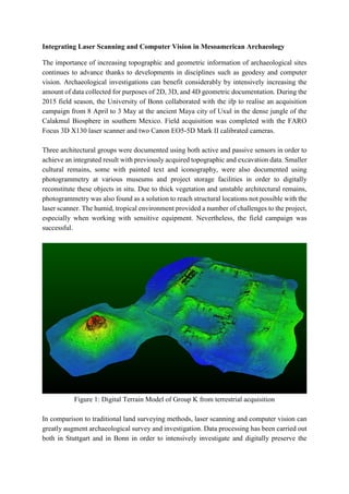
Figure 1: Digital Terrain Model of Group K from terrestrial acquisition
In comparison to traditional land surveying methods, laser scanning and computer vision can
greatly augment archaeological survey and investigation. Data processing has been carried out
both in Stuttgart and in Bonn in order to intensively investigate and digitally preserve the
2. ancient engineered landscape of the site. Deformations to architecture caused by erosion and
vegetation can be more thoroughly measured for understanding construction phases and
facilitate 3D reconstruction modelling. By segmenting the vegetation from the terrain and
architectual remains, these data additionally provide multidisciplinary research into ancient
hydrology and contemporary botany (Figure 1 and 2). Smale-scale data integration will also
contribute to new epigraphic understanding and virtual investigations of their temporal and
spatial contexts. Such examples of non-invasive techniques offer new possibilities to the field
of archaeology, especially since traditional excavation methods in essence are destructive by
their very nature. The results of this project will be interactively exhibited at museum
exhibitions at the History Museum in Speyer, Germany and the Drents Museum of Assen in
the Netherlands in 2016.
Figure 2: Point cloud with vegetation segmented of Group D
References
Grube, N. and Delvendahl, K [2015]
Informe Técnico: Temporada 2015 del Proyecto Arqueológico Uxul. Abteilung für
Altamerikanistik und Ethnologie der Universität Bonn. Bonn, October 2015.
![ancient engineered landscape of the site. Deformations to architecture caused by erosion and
vegetation can be more thoroughly measured for understanding construction phases and
facilitate 3D reconstruction modelling. By segmenting the vegetation from the terrain and
architectual remains, these data additionally provide multidisciplinary research into ancient
hydrology and contemporary botany (Figure 1 and 2). Smale-scale data integration will also
contribute to new epigraphic understanding and virtual investigations of their temporal and
spatial contexts. Such examples of non-invasive techniques offer new possibilities to the field
of archaeology, especially since traditional excavation methods in essence are destructive by
their very nature. The results of this project will be interactively exhibited at museum
exhibitions at the History Museum in Speyer, Germany and the Drents Museum of Assen in
the Netherlands in 2016.
Figure 2: Point cloud with vegetation segmented of Group D
References
Grube, N. and Delvendahl, K [2015]
Informe Técnico: Temporada 2015 del Proyecto Arqueológico Uxul. Abteilung für
Altamerikanistik und Ethnologie der Universität Bonn. Bonn, October 2015.](data:image/gif;base64,R0lGODlhAQABAIAAAAAAAP///yH5BAEAAAAALAAAAAABAAEAAAIBRAA7)