How Satellite-Derived Data Is Helping The Agriculture Sector Know With Benedict T Palen Jr
•Download as PPTX, PDF•
0 likes•4 views

Benedict T Palen Jr thinks it is due to the massive use of Global Positioning System ( GPS ) technology and images from the satellite in the modern era.

Recommended
Recommended
More Related Content
Similar to How Satellite-Derived Data Is Helping The Agriculture Sector Know With Benedict T Palen Jr
Similar to How Satellite-Derived Data Is Helping The Agriculture Sector Know With Benedict T Palen Jr (20)
More from Benedict T. Palen, Jr
More from Benedict T. Palen, Jr (20)
Recently uploaded
Recently uploaded (20)
How Satellite-Derived Data Is Helping The Agriculture Sector Know With Benedict T Palen Jr
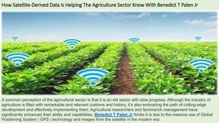
- 1. How Satellite-Derived Data Is Helping The Agriculture Sector Know With Benedict T Palen Jr A common perception of the agricultural sector is that it is an old sector with slow progress. Although the industry of agriculture is filled with remarkable and relevant customs and history, it’s also embracing the path of cutting-edge development and effectively implementing them. Agricultural researchers and farm/ranch management have significantly enhanced their ability and capabilities. Benedict T Palen Jr thinks it is due to the massive use of Global Positioning System ( GPS ) technology and images from the satellite in the modern era.
- 2. How Satellite-Derived Data Is Helping The Agriculture Sector Know With Benedict T Palen Jr What is Satellite-Derived Data? Not all satellites are made equal, nor are the picture data they produce. The goals of the satellites and the data they provide are varied for the various businesses (and governments) that run them, and the data becomes accessible at multiple temporal and spatial resolutions. Millions of pixels are combined to create satellite data related to an earthly distance. A pixel can occasionally represent one square meter of ground space, as large as 30 m2 or 1 km2. But every year, technological advancements bring spatial resolution capabilities closer to those of square centimetres.
- 3. How Satellite-Derived Data Is Helping The Agriculture Sector Know With Benedict T Palen Jr Another critical factor is the satellite data’s temporal measure. For instance, the current Landsat satellites orbit the world every 16 days. Therefore, you can only roughly predict a specific change every two weeks. Satellite photos only produce many other data products (such as land use data) annually. Utilizing Remote Sensing with Satellite Imagery While taking pictures and measuring spectrum light from the place can be very useful, these data become incredibly potent when paired with ground-based monitoring stations. According to Benedict T Palen Jr, you can use remote sensing to develop condition assessments at different geographical scales. It combines data from satellite photography with samples collected on the ground. These samples include soil samples, vegetative surveys, and weather station data. Consequently, we can approximate the conditions in areas where satellites did not collect data on the ground. The capabilities and power of remote sensing are expanding swiftly as technology advances.
- 4. How Satellite-Derived Data Is Helping The Agriculture Sector Know With Benedict T Palen Jr Remote sensing products are improving farm management through the implementation of precision agriculture. The farmer makes decisions about inputs. Inputs include the best times to water a crop or apply fertilizer. You can also use remote sensing, on-farm data, and sophisticated algorithms to make these decisions. Then, they translate this information into production projections. By using these techniques, farmers all across the United States can balance profitability and sustainability simultaneously and allocate expensive or scarce resources more strategically. Conclusion According to Benedict T Palen Jr, implementing precision agriculture is a lively way remote sensing merchandise improves farm management. The farmer collects records to make choices about crop inputs. They use faraway sensing and on-farm facts in the technique. Sophisticated algorithms translate the facts into manufacturing projections. The information helps determine the first-class instances of water and observe fertilizer. By using these techniques, farmers all across the United States can balance profitability and sustainability at an equal time and allocate pricey or scarce resources more strategically.
- 5. Learn More: https://www.youtube.com/watch?v=IlZv8dhlDSk https://www.pinterest.com/benedicttpalenjr/ https://www.prunderground.com/the-phenomenal-benedict-t-palen-jr-creating-influential- trends-in-current-agro-industry/00207184/ https://www.wattpad.com/story/225640204-benedict-t-palen-jr-provides- agricultural/rankings https://twitter.com/benedicttpalen?lang=en https://www.youtube.com/watch?v=BknLz-FUsCo https://www.youtube.com/watch?v=Az1VoWgouLk https://vimeo.com/811167409 https://benedicttpalen.wordpress.com/2021/04/12/benedict-t-palen-jr-technologies-that- are-commonly-used-in-agriculture-in-the-usa-2/ https://www.topionetworks.com/people/benedict-t-palen-jr-5bda9121105eb565d18a83a1 https://e27.co/user/benedict-t-palen-jr/