SlideShare a Scribd company logo
1 of 12
Download to read offline
1
Project Report Template
GNSS Signal Processing, Fall-18
Institute of Space Technology
ASIM KHAN
MS GNSS -7
“Extraction of Ephemeris file from Matlab code”
Introduction:
We catch a file through an RF- front end from GPS Satellites, which is now digitize data,
so in order to find user Position (X, Y, Z), we will process the digitize signal through Acquisition
and Tracking Procedure and then we get binary Data which we called Navigation bits which
usually consists of 1500 bits for each satellite which is encrypted in a frame and the frame is
divided in 5 sub frames
Sub frame 1: Clock Parameters, Space Vehicle health, user range accuracy, issue of Data clock
Sub frame 2&3: Ephemerides
Sub frame 4 & 5: Almanac Data, Space Vehicle health, UTC Data, Ionosphere Models
From step of Acquisition to end all processing is done in Matlab.
Ephemeris is the Satellite keplarian elements etc
Ephemeris Table
M0 Mean Anomaly at Reference Time
∆n Mean Motion Difference From Computed Value
e Eccentricity
√𝐴 Square Root of the Semi-Major Axis
Ω0 Longitude of Ascending Node of Orbit Plane at Weekly Epoch
i0 Inclination Angle at Reference Time
2
ω Argument of Perigee
Ω̇ Rate of Right Ascension
IDOT Rate of Inclination Angle
Cuc Amplitude of the Cosine Harmonic Correction Term to the Argument of Latitude
Cus Amplitude of the Sine Harmonic Correction Term to the Argument of Latitude
Crc Amplitude of the Cosine Harmonic Correction Term to the Orbit Radius
Crs Amplitude of the Sine Harmonic Correction Term to the Orbit Radius
Cic Amplitude of the Cosine Harmonic Correction Term to the Angle of Inclination
Cis Amplitude of the Sine Harmonic Correction Term to the Angle of Inclination
toe Reference Time Ephemeris
IODE Issue of Data (Ephemeris)
Literature review:
1. Simulations of Multiple Spacecraft Maneuvering with MATLAB/Simulink and Satellite
Tool Kit
2. GPS Clock Corrections and Orbit Computations using RINEX 2.11 GPS Navigation
Message Files
3. GNSS Introduction Fobio Dovis
Method:An additional custom code added in Postnavigation .m of GNSS SDR Matlab Code
Line 146 after check number of satellites is above 3.
for loo = 1: numel(eph)
if isempty(eph(loo).e)
else
disp('channel no')
disp(loo)
disp(eph(loo))
3
end
end
clear loo;
Explanation : the loop starts from up to ephemeris(eph)of
different satellites channel .a condition is applied of if
ephemeris and e is a variable in ephemeris chart that is present
in Matlab output .then else displaying channel number and loop
of Ephemeris of each satellite with given PRN number (Pseudo
random number ).and then end.
And the ephemeris of 7 satellites with PRN and channel Number is output Yuma file in
command window of Matlab. Or without adding in Postnavigation.m just run the above code
after Post processing is complete.
Results:In Yuma Format (Ephemeris) of different satellites of Different PRN number and
the channels they came through
channel no
1
IODE_sf2: 178
C_rs: -81
deltan: 4.5045e-09
M_0: 2.9347
C_uc: -4.2096e-06
e: 0.0050
C_us: 7.6666e-06
sqrtA: 5.1537e+03
t_oe: 381600
C_ic: -7.2643e-08
omega_0: -0.0299
4
C_is: -4.2841e-08
i_0: 0.9641
C_rc: 232.5000
omega: 0.4731
omegaDot: -7.9696e-09
IODE_sf3: 178
iDot: -2.6715e-10
weekNumber: 1881
accuracy: 0
health: 0
T_GD: 5.1223e-09
IODC: 11
t_oc: 381600
a_f2: 0
a_f1: 9.0949e-13
a_f0: 1.0263e-05
channel no
3
IODE_sf2: 33
C_rs: 17.8438
deltan: 4.4213e-09
M_0: -0.5920
C_uc: 8.4564e-07
5
e: 2.9964e-04
C_us: 1.0563e-05
sqrtA: 5.1538e+03
t_oe: 381600
C_ic: -5.5879e-09
omega_0: 1.0108
C_is: -5.5879e-09
i_0: 0.9592
C_rc: 173.5625
omega: 2.9466
omegaDot: -7.8928e-09
IODE_sf3: 33
iDot: 1.6858e-10
weekNumber: 1881
accuracy: 0
health: 0
T_GD: 1.8626e-09
IODC: 4
t_oc: 381600
a_f2: 0
a_f1: -4.8885e-12
a_f0: -1.7368e-05
channel no
10
6
IODE_sf2: 65
C_rs: 4.1875
deltan: 4.4873e-09
M_0: 0.8468
C_uc: 3.0547e-07
e: 0.0011
C_us: 1.0315e-05
sqrtA: 5.1537e+03
t_oe: 381600
C_ic: 1.6764e-08
omega_0: 1.0067
C_is: -2.9802e-08
i_0: 0.9595
C_rc: 177.5625
omega: -2.9359
omegaDot: -7.9743e-09
IODE_sf3: 65
iDot: 1.2251e-10
weekNumber: 1881
accuracy: 1
health: 0
T_GD: 2.3283e-09
IODC: 5
t_oc: 381600
7
a_f2: 0
a_f1: -2.0464e-12
a_f0: 4.8256e-05
channel no
14
IODE_sf2: 38
C_rs: 27.6875
deltan: 4.7488e-09
M_0: -1.2603
C_uc: 1.5274e-06
e: 0.0083
C_us: 5.1763e-06
sqrtA: 5.1537e+03
t_oe: 381600
C_ic: 9.8720e-08
omega_0: 2.1344
C_is: 2.1607e-07
i_0: 0.9644
C_rc: 283.3438
omega: -1.9490
omegaDot: -8.2643e-09
IODE_sf3: 38
iDot: -6.4288e-12
8
weekNumber: 1881
accuracy: 0
health: 0
T_GD: -9.3132e-09
IODC: 236
t_oc: 381600
a_f2: 0
a_f1: -2.2737e-12
a_f0: 6.4904e-06
channel no
22
IODE_sf2: 12
C_rs: 10.8438
deltan: 5.2949e-09
M_0: -0.6614
C_uc: 5.1595e-07
e: 0.0076
C_us: 1.0097e-05
sqrtA: 5.1551e+03
t_oe: 381584
C_ic: -8.1956e-08
omega_0: 0.9828
C_is: 1.0990e-07
9
i_0: 0.9228
C_rc: 163.1250
omega: -2.0254
omegaDot: -8.4761e-09
IODE_sf3: 12
iDot: 1.0858e-10
weekNumber: 1881
accuracy: 0
health: 0
T_GD: -1.7695e-08
IODC: 218
t_oc: 381584
a_f2: 0
a_f1: -5.3433e-12
a_f0: 4.0550e-04
channel no
25
IODE_sf2: 46
C_rs: 46.0313
deltan: 3.9116e-09
M_0: 1.2557
C_uc: 2.3227e-06
e: 0.0050
10
C_us: 1.0280e-05
sqrtA: 5.1536e+03
t_oe: 381600
C_ic: -1.3039e-08
omega_0: -2.1302
C_is: 6.5193e-08
i_0: 0.9786
C_rc: 188.5625
omega: 0.6937
omegaDot: -7.8664e-09
IODE_sf3: 46
iDot: 1.4929e-10
weekNumber: 1881
accuracy: 0
health: 0
T_GD: 5.5879e-09
IODC: 12
t_oc: 381600
a_f2: 0
a_f1: -6.4801e-12
a_f0: -1.0712e-04
channel no
31
11
IODE_sf2: 78
C_rs: -26.4063
deltan: 4.1866e-09
M_0: 2.2049
C_uc: -1.2014e-06
e: 0.0083
C_us: 8.0280e-06
sqrtA: 5.1537e+03
t_oe: 381600
C_ic: 1.6764e-08
omega_0: 3.1381
C_is: 5.7742e-08
i_0: 0.9728
C_rc: 231.8125
omega: -0.4432
omegaDot: -7.8293e-09
IODE_sf3: 78
iDot: -4.4073e-10
weekNumber: 1881
accuracy: 0
health: 0
T_GD: -1.3504e-08
IODC: 227
t_oc: 381600
a_f2: 0
12
a_f1: -1.5916e-12
a_f0: 2.8513e-04
Conclusion:As we know Ephemeris file is present in each Satellite signal and we extract
Ephemerides of each Satellite through a Software defined Radio Matlab code for GPS Signals
.which allows us smooth and soft access to satellite position, which can we use for multiple
tasks ,at the time it helps us for finding the user location in X,Y,Z (latitude ,longitude and
height).

More Related Content

What's hot

GNSS Satellite System Basics by ASIM khan GNSS-7
GNSS Satellite System Basics  by ASIM khan GNSS-7GNSS Satellite System Basics  by ASIM khan GNSS-7
GNSS Satellite System Basics by ASIM khan GNSS-7AsimKhan367
 
Introduction to gps and gnss
Introduction to gps and gnssIntroduction to gps and gnss
Introduction to gps and gnssVivek Srivastava
 
Navigation Position: Sea Scout Ship 378
Navigation Position: Sea Scout Ship 378Navigation Position: Sea Scout Ship 378
Navigation Position: Sea Scout Ship 378Sam Young
 
Global Positioning System
Global Positioning System Global Positioning System
Global Positioning System Varun B P
 
CE6404 ANNA UNIVERSITY Unit iv gps surveying
CE6404 ANNA UNIVERSITY Unit iv gps surveyingCE6404 ANNA UNIVERSITY Unit iv gps surveying
CE6404 ANNA UNIVERSITY Unit iv gps surveyingDr Gopikrishnan T
 
Application of differential systems in global navigation satellite systems
Application of differential systems in global navigation satellite systemsApplication of differential systems in global navigation satellite systems
Application of differential systems in global navigation satellite systemsAli N.Khojasteh
 
Gps( global positioning system) 2010
Gps( global positioning system) 2010Gps( global positioning system) 2010
Gps( global positioning system) 2010Mohamed _el_shora
 
Conceptual design and architecture of turkish communication satellite turksat...
Conceptual design and architecture of turkish communication satellite turksat...Conceptual design and architecture of turkish communication satellite turksat...
Conceptual design and architecture of turkish communication satellite turksat...Atılay Mayadağ
 
Lecture satellite navigation
Lecture   satellite navigationLecture   satellite navigation
Lecture satellite navigationzannuar
 
GPS (GLOBAL POSITIONING SYSTEM)
GPS (GLOBAL POSITIONING SYSTEM)GPS (GLOBAL POSITIONING SYSTEM)
GPS (GLOBAL POSITIONING SYSTEM)Abdul mannan Karim
 
TH1.L10.2: TANDEM-X COMMISSIONING PHASE STATUS
TH1.L10.2: TANDEM-X COMMISSIONING PHASE STATUSTH1.L10.2: TANDEM-X COMMISSIONING PHASE STATUS
TH1.L10.2: TANDEM-X COMMISSIONING PHASE STATUSgrssieee
 
GPS Retransmission Introduction
GPS Retransmission IntroductionGPS Retransmission Introduction
GPS Retransmission Introductioncptnboom
 

What's hot (20)

GNSS Satellite System Basics by ASIM khan GNSS-7
GNSS Satellite System Basics  by ASIM khan GNSS-7GNSS Satellite System Basics  by ASIM khan GNSS-7
GNSS Satellite System Basics by ASIM khan GNSS-7
 
Introduction to gps and gnss
Introduction to gps and gnssIntroduction to gps and gnss
Introduction to gps and gnss
 
introduction-of-GNSS-1
introduction-of-GNSS-1introduction-of-GNSS-1
introduction-of-GNSS-1
 
GPS introduction
GPS introductionGPS introduction
GPS introduction
 
Navigation Position: Sea Scout Ship 378
Navigation Position: Sea Scout Ship 378Navigation Position: Sea Scout Ship 378
Navigation Position: Sea Scout Ship 378
 
Unit 4 DGPS
Unit 4 DGPSUnit 4 DGPS
Unit 4 DGPS
 
Global Positioning System
Global Positioning System Global Positioning System
Global Positioning System
 
CE6404 ANNA UNIVERSITY Unit iv gps surveying
CE6404 ANNA UNIVERSITY Unit iv gps surveyingCE6404 ANNA UNIVERSITY Unit iv gps surveying
CE6404 ANNA UNIVERSITY Unit iv gps surveying
 
Application of differential systems in global navigation satellite systems
Application of differential systems in global navigation satellite systemsApplication of differential systems in global navigation satellite systems
Application of differential systems in global navigation satellite systems
 
GPS
GPSGPS
GPS
 
Gps( global positioning system) 2010
Gps( global positioning system) 2010Gps( global positioning system) 2010
Gps( global positioning system) 2010
 
Multi-constellation GNSS Simulator
Multi-constellation GNSS SimulatorMulti-constellation GNSS Simulator
Multi-constellation GNSS Simulator
 
Conceptual design and architecture of turkish communication satellite turksat...
Conceptual design and architecture of turkish communication satellite turksat...Conceptual design and architecture of turkish communication satellite turksat...
Conceptual design and architecture of turkish communication satellite turksat...
 
Lecture satellite navigation
Lecture   satellite navigationLecture   satellite navigation
Lecture satellite navigation
 
GPS (GLOBAL POSITIONING SYSTEM)
GPS (GLOBAL POSITIONING SYSTEM)GPS (GLOBAL POSITIONING SYSTEM)
GPS (GLOBAL POSITIONING SYSTEM)
 
Abstract of gps
Abstract of gpsAbstract of gps
Abstract of gps
 
Introduction to GPS presentation
Introduction to GPS presentationIntroduction to GPS presentation
Introduction to GPS presentation
 
TH1.L10.2: TANDEM-X COMMISSIONING PHASE STATUS
TH1.L10.2: TANDEM-X COMMISSIONING PHASE STATUSTH1.L10.2: TANDEM-X COMMISSIONING PHASE STATUS
TH1.L10.2: TANDEM-X COMMISSIONING PHASE STATUS
 
GPS Retransmission Introduction
GPS Retransmission IntroductionGPS Retransmission Introduction
GPS Retransmission Introduction
 
Gps
GpsGps
Gps
 

Similar to Extraction of Ephemeris file from Matlab SDR

#4 gps introduction & gps messages
#4 gps introduction & gps messages#4 gps introduction & gps messages
#4 gps introduction & gps messagesMohammedHusain20
 
Point Sum Average Peak Algorithm Detection of LTE
Point Sum Average Peak Algorithm Detection of LTEPoint Sum Average Peak Algorithm Detection of LTE
Point Sum Average Peak Algorithm Detection of LTEAM Publications
 
IJERD (www.ijerd.com) International Journal of Engineering Research and Devel...
IJERD (www.ijerd.com) International Journal of Engineering Research and Devel...IJERD (www.ijerd.com) International Journal of Engineering Research and Devel...
IJERD (www.ijerd.com) International Journal of Engineering Research and Devel...IJERD Editor
 
maXbox starter 34 GPS Tutorial
maXbox starter 34 GPS TutorialmaXbox starter 34 GPS Tutorial
maXbox starter 34 GPS TutorialMax Kleiner
 
Introducing the Galileo PVT App:from Assisted GNSS to NeQuick model in Android
Introducing the Galileo PVT App:from Assisted GNSS to NeQuick model in AndroidIntroducing the Galileo PVT App:from Assisted GNSS to NeQuick model in Android
Introducing the Galileo PVT App:from Assisted GNSS to NeQuick model in AndroidThe European GNSS Agency (GSA)
 
Presentation for the 19th EUROSTAR Users Conference June 2011
Presentation for the 19th EUROSTAR Users Conference June 2011Presentation for the 19th EUROSTAR Users Conference June 2011
Presentation for the 19th EUROSTAR Users Conference June 2011Antonios Arkas
 
Understanding GPS & NMEA Messages and Algo to extract Information from NMEA.
Understanding GPS & NMEA Messages and Algo to extract Information from NMEA.Understanding GPS & NMEA Messages and Algo to extract Information from NMEA.
Understanding GPS & NMEA Messages and Algo to extract Information from NMEA.Robo India
 
Cyclostationary analysis of polytime coded signals for lpi radars
Cyclostationary analysis of polytime coded signals for lpi radarsCyclostationary analysis of polytime coded signals for lpi radars
Cyclostationary analysis of polytime coded signals for lpi radarseSAT Journals
 
Design and implementation of GPS Tracker
Design and implementation of GPS TrackerDesign and implementation of GPS Tracker
Design and implementation of GPS TrackerVignesh Kannan
 
TH2.L10.4: SMOS L1 ALGORITHMS
TH2.L10.4: SMOS L1 ALGORITHMSTH2.L10.4: SMOS L1 ALGORITHMS
TH2.L10.4: SMOS L1 ALGORITHMSgrssieee
 
MIRAS: the instrument aboard SMOS
MIRAS: the instrument aboard SMOSMIRAS: the instrument aboard SMOS
MIRAS: the instrument aboard SMOSadrianocamps
 
Unit II GPS Signal Characteristics
Unit II GPS Signal CharacteristicsUnit II GPS Signal Characteristics
Unit II GPS Signal CharacteristicsGVNSK Sravya
 
A SWITCHED-ANTENNA NADIR-LOOKING INTERFEROMETRIC SAR ALTIMETER FOR TERRAIN-AI...
A SWITCHED-ANTENNA NADIR-LOOKING INTERFEROMETRIC SAR ALTIMETER FOR TERRAIN-AI...A SWITCHED-ANTENNA NADIR-LOOKING INTERFEROMETRIC SAR ALTIMETER FOR TERRAIN-AI...
A SWITCHED-ANTENNA NADIR-LOOKING INTERFEROMETRIC SAR ALTIMETER FOR TERRAIN-AI...cscpconf
 
A SWITCHED-ANTENNA NADIR-LOOKING INTERFEROMETRIC SAR ALTIMETER FOR TERRAIN-AI...
A SWITCHED-ANTENNA NADIR-LOOKING INTERFEROMETRIC SAR ALTIMETER FOR TERRAIN-AI...A SWITCHED-ANTENNA NADIR-LOOKING INTERFEROMETRIC SAR ALTIMETER FOR TERRAIN-AI...
A SWITCHED-ANTENNA NADIR-LOOKING INTERFEROMETRIC SAR ALTIMETER FOR TERRAIN-AI...csandit
 
Evaluation of BER in LTE System using Various Modulation Techniques over diff...
Evaluation of BER in LTE System using Various Modulation Techniques over diff...Evaluation of BER in LTE System using Various Modulation Techniques over diff...
Evaluation of BER in LTE System using Various Modulation Techniques over diff...ijtsrd
 

Similar to Extraction of Ephemeris file from Matlab SDR (20)

GPS Group 9 Project
GPS Group 9 ProjectGPS Group 9 Project
GPS Group 9 Project
 
#4 gps introduction & gps messages
#4 gps introduction & gps messages#4 gps introduction & gps messages
#4 gps introduction & gps messages
 
Point Sum Average Peak Algorithm Detection of LTE
Point Sum Average Peak Algorithm Detection of LTEPoint Sum Average Peak Algorithm Detection of LTE
Point Sum Average Peak Algorithm Detection of LTE
 
phase shifter
phase shifterphase shifter
phase shifter
 
IJERD (www.ijerd.com) International Journal of Engineering Research and Devel...
IJERD (www.ijerd.com) International Journal of Engineering Research and Devel...IJERD (www.ijerd.com) International Journal of Engineering Research and Devel...
IJERD (www.ijerd.com) International Journal of Engineering Research and Devel...
 
maXbox starter 34 GPS Tutorial
maXbox starter 34 GPS TutorialmaXbox starter 34 GPS Tutorial
maXbox starter 34 GPS Tutorial
 
Introducing the Galileo PVT App:from Assisted GNSS to NeQuick model in Android
Introducing the Galileo PVT App:from Assisted GNSS to NeQuick model in AndroidIntroducing the Galileo PVT App:from Assisted GNSS to NeQuick model in Android
Introducing the Galileo PVT App:from Assisted GNSS to NeQuick model in Android
 
Presentation for the 19th EUROSTAR Users Conference June 2011
Presentation for the 19th EUROSTAR Users Conference June 2011Presentation for the 19th EUROSTAR Users Conference June 2011
Presentation for the 19th EUROSTAR Users Conference June 2011
 
TRS
TRSTRS
TRS
 
Understanding GPS & NMEA Messages and Algo to extract Information from NMEA.
Understanding GPS & NMEA Messages and Algo to extract Information from NMEA.Understanding GPS & NMEA Messages and Algo to extract Information from NMEA.
Understanding GPS & NMEA Messages and Algo to extract Information from NMEA.
 
Cyclostationary analysis of polytime coded signals for lpi radars
Cyclostationary analysis of polytime coded signals for lpi radarsCyclostationary analysis of polytime coded signals for lpi radars
Cyclostationary analysis of polytime coded signals for lpi radars
 
Design and implementation of GPS Tracker
Design and implementation of GPS TrackerDesign and implementation of GPS Tracker
Design and implementation of GPS Tracker
 
TH2.L10.4: SMOS L1 ALGORITHMS
TH2.L10.4: SMOS L1 ALGORITHMSTH2.L10.4: SMOS L1 ALGORITHMS
TH2.L10.4: SMOS L1 ALGORITHMS
 
MIRAS: the instrument aboard SMOS
MIRAS: the instrument aboard SMOSMIRAS: the instrument aboard SMOS
MIRAS: the instrument aboard SMOS
 
Unit II GPS Signal Characteristics
Unit II GPS Signal CharacteristicsUnit II GPS Signal Characteristics
Unit II GPS Signal Characteristics
 
JGrass-Newage SWRB
JGrass-Newage SWRBJGrass-Newage SWRB
JGrass-Newage SWRB
 
B045012015
B045012015B045012015
B045012015
 
A SWITCHED-ANTENNA NADIR-LOOKING INTERFEROMETRIC SAR ALTIMETER FOR TERRAIN-AI...
A SWITCHED-ANTENNA NADIR-LOOKING INTERFEROMETRIC SAR ALTIMETER FOR TERRAIN-AI...A SWITCHED-ANTENNA NADIR-LOOKING INTERFEROMETRIC SAR ALTIMETER FOR TERRAIN-AI...
A SWITCHED-ANTENNA NADIR-LOOKING INTERFEROMETRIC SAR ALTIMETER FOR TERRAIN-AI...
 
A SWITCHED-ANTENNA NADIR-LOOKING INTERFEROMETRIC SAR ALTIMETER FOR TERRAIN-AI...
A SWITCHED-ANTENNA NADIR-LOOKING INTERFEROMETRIC SAR ALTIMETER FOR TERRAIN-AI...A SWITCHED-ANTENNA NADIR-LOOKING INTERFEROMETRIC SAR ALTIMETER FOR TERRAIN-AI...
A SWITCHED-ANTENNA NADIR-LOOKING INTERFEROMETRIC SAR ALTIMETER FOR TERRAIN-AI...
 
Evaluation of BER in LTE System using Various Modulation Techniques over diff...
Evaluation of BER in LTE System using Various Modulation Techniques over diff...Evaluation of BER in LTE System using Various Modulation Techniques over diff...
Evaluation of BER in LTE System using Various Modulation Techniques over diff...
 

Recently uploaded

Tech-Forward - Achieving Business Readiness For Copilot in Microsoft 365
Tech-Forward - Achieving Business Readiness For Copilot in Microsoft 365Tech-Forward - Achieving Business Readiness For Copilot in Microsoft 365
Tech-Forward - Achieving Business Readiness For Copilot in Microsoft 3652toLead Limited
 
Transcript: New from BookNet Canada for 2024: BNC CataList - Tech Forum 2024
Transcript: New from BookNet Canada for 2024: BNC CataList - Tech Forum 2024Transcript: New from BookNet Canada for 2024: BNC CataList - Tech Forum 2024
Transcript: New from BookNet Canada for 2024: BNC CataList - Tech Forum 2024BookNet Canada
 
Beyond Boundaries: Leveraging No-Code Solutions for Industry Innovation
Beyond Boundaries: Leveraging No-Code Solutions for Industry InnovationBeyond Boundaries: Leveraging No-Code Solutions for Industry Innovation
Beyond Boundaries: Leveraging No-Code Solutions for Industry InnovationSafe Software
 
"Subclassing and Composition – A Pythonic Tour of Trade-Offs", Hynek Schlawack
"Subclassing and Composition – A Pythonic Tour of Trade-Offs", Hynek Schlawack"Subclassing and Composition – A Pythonic Tour of Trade-Offs", Hynek Schlawack
"Subclassing and Composition – A Pythonic Tour of Trade-Offs", Hynek SchlawackFwdays
 
"Federated learning: out of reach no matter how close",Oleksandr Lapshyn
"Federated learning: out of reach no matter how close",Oleksandr Lapshyn"Federated learning: out of reach no matter how close",Oleksandr Lapshyn
"Federated learning: out of reach no matter how close",Oleksandr LapshynFwdays
 
Scanning the Internet for External Cloud Exposures via SSL Certs
Scanning the Internet for External Cloud Exposures via SSL CertsScanning the Internet for External Cloud Exposures via SSL Certs
Scanning the Internet for External Cloud Exposures via SSL CertsRizwan Syed
 
Bun (KitWorks Team Study 노별마루 발표 2024.4.22)
Bun (KitWorks Team Study 노별마루 발표 2024.4.22)Bun (KitWorks Team Study 노별마루 발표 2024.4.22)
Bun (KitWorks Team Study 노별마루 발표 2024.4.22)Wonjun Hwang
 
Nell’iperspazio con Rocket: il Framework Web di Rust!
Nell’iperspazio con Rocket: il Framework Web di Rust!Nell’iperspazio con Rocket: il Framework Web di Rust!
Nell’iperspazio con Rocket: il Framework Web di Rust!Commit University
 
"LLMs for Python Engineers: Advanced Data Analysis and Semantic Kernel",Oleks...
"LLMs for Python Engineers: Advanced Data Analysis and Semantic Kernel",Oleks..."LLMs for Python Engineers: Advanced Data Analysis and Semantic Kernel",Oleks...
"LLMs for Python Engineers: Advanced Data Analysis and Semantic Kernel",Oleks...Fwdays
 
Commit 2024 - Secret Management made easy
Commit 2024 - Secret Management made easyCommit 2024 - Secret Management made easy
Commit 2024 - Secret Management made easyAlfredo García Lavilla
 
DevEX - reference for building teams, processes, and platforms
DevEX - reference for building teams, processes, and platformsDevEX - reference for building teams, processes, and platforms
DevEX - reference for building teams, processes, and platformsSergiu Bodiu
 
Automating Business Process via MuleSoft Composer | Bangalore MuleSoft Meetup...
Automating Business Process via MuleSoft Composer | Bangalore MuleSoft Meetup...Automating Business Process via MuleSoft Composer | Bangalore MuleSoft Meetup...
Automating Business Process via MuleSoft Composer | Bangalore MuleSoft Meetup...shyamraj55
 
WordPress Websites for Engineers: Elevate Your Brand
WordPress Websites for Engineers: Elevate Your BrandWordPress Websites for Engineers: Elevate Your Brand
WordPress Websites for Engineers: Elevate Your Brandgvaughan
 
Ensuring Technical Readiness For Copilot in Microsoft 365
Ensuring Technical Readiness For Copilot in Microsoft 365Ensuring Technical Readiness For Copilot in Microsoft 365
Ensuring Technical Readiness For Copilot in Microsoft 3652toLead Limited
 
Advanced Test Driven-Development @ php[tek] 2024
Advanced Test Driven-Development @ php[tek] 2024Advanced Test Driven-Development @ php[tek] 2024
Advanced Test Driven-Development @ php[tek] 2024Scott Keck-Warren
 
Are Multi-Cloud and Serverless Good or Bad?
Are Multi-Cloud and Serverless Good or Bad?Are Multi-Cloud and Serverless Good or Bad?
Are Multi-Cloud and Serverless Good or Bad?Mattias Andersson
 
AI as an Interface for Commercial Buildings
AI as an Interface for Commercial BuildingsAI as an Interface for Commercial Buildings
AI as an Interface for Commercial BuildingsMemoori
 
"Debugging python applications inside k8s environment", Andrii Soldatenko
"Debugging python applications inside k8s environment", Andrii Soldatenko"Debugging python applications inside k8s environment", Andrii Soldatenko
"Debugging python applications inside k8s environment", Andrii SoldatenkoFwdays
 

Recently uploaded (20)

E-Vehicle_Hacking_by_Parul Sharma_null_owasp.pptx
E-Vehicle_Hacking_by_Parul Sharma_null_owasp.pptxE-Vehicle_Hacking_by_Parul Sharma_null_owasp.pptx
E-Vehicle_Hacking_by_Parul Sharma_null_owasp.pptx
 
Tech-Forward - Achieving Business Readiness For Copilot in Microsoft 365
Tech-Forward - Achieving Business Readiness For Copilot in Microsoft 365Tech-Forward - Achieving Business Readiness For Copilot in Microsoft 365
Tech-Forward - Achieving Business Readiness For Copilot in Microsoft 365
 
Transcript: New from BookNet Canada for 2024: BNC CataList - Tech Forum 2024
Transcript: New from BookNet Canada for 2024: BNC CataList - Tech Forum 2024Transcript: New from BookNet Canada for 2024: BNC CataList - Tech Forum 2024
Transcript: New from BookNet Canada for 2024: BNC CataList - Tech Forum 2024
 
Beyond Boundaries: Leveraging No-Code Solutions for Industry Innovation
Beyond Boundaries: Leveraging No-Code Solutions for Industry InnovationBeyond Boundaries: Leveraging No-Code Solutions for Industry Innovation
Beyond Boundaries: Leveraging No-Code Solutions for Industry Innovation
 
"Subclassing and Composition – A Pythonic Tour of Trade-Offs", Hynek Schlawack
"Subclassing and Composition – A Pythonic Tour of Trade-Offs", Hynek Schlawack"Subclassing and Composition – A Pythonic Tour of Trade-Offs", Hynek Schlawack
"Subclassing and Composition – A Pythonic Tour of Trade-Offs", Hynek Schlawack
 
"Federated learning: out of reach no matter how close",Oleksandr Lapshyn
"Federated learning: out of reach no matter how close",Oleksandr Lapshyn"Federated learning: out of reach no matter how close",Oleksandr Lapshyn
"Federated learning: out of reach no matter how close",Oleksandr Lapshyn
 
Scanning the Internet for External Cloud Exposures via SSL Certs
Scanning the Internet for External Cloud Exposures via SSL CertsScanning the Internet for External Cloud Exposures via SSL Certs
Scanning the Internet for External Cloud Exposures via SSL Certs
 
Bun (KitWorks Team Study 노별마루 발표 2024.4.22)
Bun (KitWorks Team Study 노별마루 발표 2024.4.22)Bun (KitWorks Team Study 노별마루 발표 2024.4.22)
Bun (KitWorks Team Study 노별마루 발표 2024.4.22)
 
Nell’iperspazio con Rocket: il Framework Web di Rust!
Nell’iperspazio con Rocket: il Framework Web di Rust!Nell’iperspazio con Rocket: il Framework Web di Rust!
Nell’iperspazio con Rocket: il Framework Web di Rust!
 
"LLMs for Python Engineers: Advanced Data Analysis and Semantic Kernel",Oleks...
"LLMs for Python Engineers: Advanced Data Analysis and Semantic Kernel",Oleks..."LLMs for Python Engineers: Advanced Data Analysis and Semantic Kernel",Oleks...
"LLMs for Python Engineers: Advanced Data Analysis and Semantic Kernel",Oleks...
 
Commit 2024 - Secret Management made easy
Commit 2024 - Secret Management made easyCommit 2024 - Secret Management made easy
Commit 2024 - Secret Management made easy
 
DevEX - reference for building teams, processes, and platforms
DevEX - reference for building teams, processes, and platformsDevEX - reference for building teams, processes, and platforms
DevEX - reference for building teams, processes, and platforms
 
Automating Business Process via MuleSoft Composer | Bangalore MuleSoft Meetup...
Automating Business Process via MuleSoft Composer | Bangalore MuleSoft Meetup...Automating Business Process via MuleSoft Composer | Bangalore MuleSoft Meetup...
Automating Business Process via MuleSoft Composer | Bangalore MuleSoft Meetup...
 
WordPress Websites for Engineers: Elevate Your Brand
WordPress Websites for Engineers: Elevate Your BrandWordPress Websites for Engineers: Elevate Your Brand
WordPress Websites for Engineers: Elevate Your Brand
 
Ensuring Technical Readiness For Copilot in Microsoft 365
Ensuring Technical Readiness For Copilot in Microsoft 365Ensuring Technical Readiness For Copilot in Microsoft 365
Ensuring Technical Readiness For Copilot in Microsoft 365
 
Advanced Test Driven-Development @ php[tek] 2024
Advanced Test Driven-Development @ php[tek] 2024Advanced Test Driven-Development @ php[tek] 2024
Advanced Test Driven-Development @ php[tek] 2024
 
Are Multi-Cloud and Serverless Good or Bad?
Are Multi-Cloud and Serverless Good or Bad?Are Multi-Cloud and Serverless Good or Bad?
Are Multi-Cloud and Serverless Good or Bad?
 
Hot Sexy call girls in Panjabi Bagh 🔝 9953056974 🔝 Delhi escort Service
Hot Sexy call girls in Panjabi Bagh 🔝 9953056974 🔝 Delhi escort ServiceHot Sexy call girls in Panjabi Bagh 🔝 9953056974 🔝 Delhi escort Service
Hot Sexy call girls in Panjabi Bagh 🔝 9953056974 🔝 Delhi escort Service
 
AI as an Interface for Commercial Buildings
AI as an Interface for Commercial BuildingsAI as an Interface for Commercial Buildings
AI as an Interface for Commercial Buildings
 
"Debugging python applications inside k8s environment", Andrii Soldatenko
"Debugging python applications inside k8s environment", Andrii Soldatenko"Debugging python applications inside k8s environment", Andrii Soldatenko
"Debugging python applications inside k8s environment", Andrii Soldatenko
 

Extraction of Ephemeris file from Matlab SDR

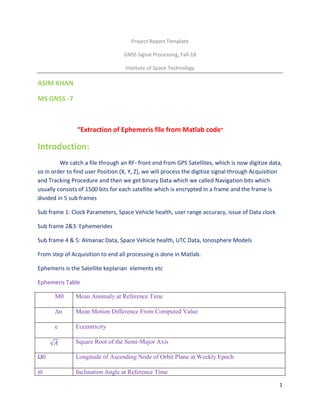
  • 1. 1 Project Report Template GNSS Signal Processing, Fall-18 Institute of Space Technology ASIM KHAN MS GNSS -7 “Extraction of Ephemeris file from Matlab code” Introduction: We catch a file through an RF- front end from GPS Satellites, which is now digitize data, so in order to find user Position (X, Y, Z), we will process the digitize signal through Acquisition and Tracking Procedure and then we get binary Data which we called Navigation bits which usually consists of 1500 bits for each satellite which is encrypted in a frame and the frame is divided in 5 sub frames Sub frame 1: Clock Parameters, Space Vehicle health, user range accuracy, issue of Data clock Sub frame 2&3: Ephemerides Sub frame 4 & 5: Almanac Data, Space Vehicle health, UTC Data, Ionosphere Models From step of Acquisition to end all processing is done in Matlab. Ephemeris is the Satellite keplarian elements etc Ephemeris Table M0 Mean Anomaly at Reference Time ∆n Mean Motion Difference From Computed Value e Eccentricity √𝐴 Square Root of the Semi-Major Axis Ω0 Longitude of Ascending Node of Orbit Plane at Weekly Epoch i0 Inclination Angle at Reference Time
  • 2. 2 ω Argument of Perigee Ω̇ Rate of Right Ascension IDOT Rate of Inclination Angle Cuc Amplitude of the Cosine Harmonic Correction Term to the Argument of Latitude Cus Amplitude of the Sine Harmonic Correction Term to the Argument of Latitude Crc Amplitude of the Cosine Harmonic Correction Term to the Orbit Radius Crs Amplitude of the Sine Harmonic Correction Term to the Orbit Radius Cic Amplitude of the Cosine Harmonic Correction Term to the Angle of Inclination Cis Amplitude of the Sine Harmonic Correction Term to the Angle of Inclination toe Reference Time Ephemeris IODE Issue of Data (Ephemeris) Literature review: 1. Simulations of Multiple Spacecraft Maneuvering with MATLAB/Simulink and Satellite Tool Kit 2. GPS Clock Corrections and Orbit Computations using RINEX 2.11 GPS Navigation Message Files 3. GNSS Introduction Fobio Dovis Method:An additional custom code added in Postnavigation .m of GNSS SDR Matlab Code Line 146 after check number of satellites is above 3. for loo = 1: numel(eph) if isempty(eph(loo).e) else disp('channel no') disp(loo) disp(eph(loo))
  • 3. 3 end end clear loo; Explanation : the loop starts from up to ephemeris(eph)of different satellites channel .a condition is applied of if ephemeris and e is a variable in ephemeris chart that is present in Matlab output .then else displaying channel number and loop of Ephemeris of each satellite with given PRN number (Pseudo random number ).and then end. And the ephemeris of 7 satellites with PRN and channel Number is output Yuma file in command window of Matlab. Or without adding in Postnavigation.m just run the above code after Post processing is complete. Results:In Yuma Format (Ephemeris) of different satellites of Different PRN number and the channels they came through channel no 1 IODE_sf2: 178 C_rs: -81 deltan: 4.5045e-09 M_0: 2.9347 C_uc: -4.2096e-06 e: 0.0050 C_us: 7.6666e-06 sqrtA: 5.1537e+03 t_oe: 381600 C_ic: -7.2643e-08 omega_0: -0.0299
  • 4. 4 C_is: -4.2841e-08 i_0: 0.9641 C_rc: 232.5000 omega: 0.4731 omegaDot: -7.9696e-09 IODE_sf3: 178 iDot: -2.6715e-10 weekNumber: 1881 accuracy: 0 health: 0 T_GD: 5.1223e-09 IODC: 11 t_oc: 381600 a_f2: 0 a_f1: 9.0949e-13 a_f0: 1.0263e-05 channel no 3 IODE_sf2: 33 C_rs: 17.8438 deltan: 4.4213e-09 M_0: -0.5920 C_uc: 8.4564e-07
  • 5. 5 e: 2.9964e-04 C_us: 1.0563e-05 sqrtA: 5.1538e+03 t_oe: 381600 C_ic: -5.5879e-09 omega_0: 1.0108 C_is: -5.5879e-09 i_0: 0.9592 C_rc: 173.5625 omega: 2.9466 omegaDot: -7.8928e-09 IODE_sf3: 33 iDot: 1.6858e-10 weekNumber: 1881 accuracy: 0 health: 0 T_GD: 1.8626e-09 IODC: 4 t_oc: 381600 a_f2: 0 a_f1: -4.8885e-12 a_f0: -1.7368e-05 channel no 10
  • 6. 6 IODE_sf2: 65 C_rs: 4.1875 deltan: 4.4873e-09 M_0: 0.8468 C_uc: 3.0547e-07 e: 0.0011 C_us: 1.0315e-05 sqrtA: 5.1537e+03 t_oe: 381600 C_ic: 1.6764e-08 omega_0: 1.0067 C_is: -2.9802e-08 i_0: 0.9595 C_rc: 177.5625 omega: -2.9359 omegaDot: -7.9743e-09 IODE_sf3: 65 iDot: 1.2251e-10 weekNumber: 1881 accuracy: 1 health: 0 T_GD: 2.3283e-09 IODC: 5 t_oc: 381600
  • 7. 7 a_f2: 0 a_f1: -2.0464e-12 a_f0: 4.8256e-05 channel no 14 IODE_sf2: 38 C_rs: 27.6875 deltan: 4.7488e-09 M_0: -1.2603 C_uc: 1.5274e-06 e: 0.0083 C_us: 5.1763e-06 sqrtA: 5.1537e+03 t_oe: 381600 C_ic: 9.8720e-08 omega_0: 2.1344 C_is: 2.1607e-07 i_0: 0.9644 C_rc: 283.3438 omega: -1.9490 omegaDot: -8.2643e-09 IODE_sf3: 38 iDot: -6.4288e-12
  • 8. 8 weekNumber: 1881 accuracy: 0 health: 0 T_GD: -9.3132e-09 IODC: 236 t_oc: 381600 a_f2: 0 a_f1: -2.2737e-12 a_f0: 6.4904e-06 channel no 22 IODE_sf2: 12 C_rs: 10.8438 deltan: 5.2949e-09 M_0: -0.6614 C_uc: 5.1595e-07 e: 0.0076 C_us: 1.0097e-05 sqrtA: 5.1551e+03 t_oe: 381584 C_ic: -8.1956e-08 omega_0: 0.9828 C_is: 1.0990e-07
  • 9. 9 i_0: 0.9228 C_rc: 163.1250 omega: -2.0254 omegaDot: -8.4761e-09 IODE_sf3: 12 iDot: 1.0858e-10 weekNumber: 1881 accuracy: 0 health: 0 T_GD: -1.7695e-08 IODC: 218 t_oc: 381584 a_f2: 0 a_f1: -5.3433e-12 a_f0: 4.0550e-04 channel no 25 IODE_sf2: 46 C_rs: 46.0313 deltan: 3.9116e-09 M_0: 1.2557 C_uc: 2.3227e-06 e: 0.0050
  • 10. 10 C_us: 1.0280e-05 sqrtA: 5.1536e+03 t_oe: 381600 C_ic: -1.3039e-08 omega_0: -2.1302 C_is: 6.5193e-08 i_0: 0.9786 C_rc: 188.5625 omega: 0.6937 omegaDot: -7.8664e-09 IODE_sf3: 46 iDot: 1.4929e-10 weekNumber: 1881 accuracy: 0 health: 0 T_GD: 5.5879e-09 IODC: 12 t_oc: 381600 a_f2: 0 a_f1: -6.4801e-12 a_f0: -1.0712e-04 channel no 31
  • 11. 11 IODE_sf2: 78 C_rs: -26.4063 deltan: 4.1866e-09 M_0: 2.2049 C_uc: -1.2014e-06 e: 0.0083 C_us: 8.0280e-06 sqrtA: 5.1537e+03 t_oe: 381600 C_ic: 1.6764e-08 omega_0: 3.1381 C_is: 5.7742e-08 i_0: 0.9728 C_rc: 231.8125 omega: -0.4432 omegaDot: -7.8293e-09 IODE_sf3: 78 iDot: -4.4073e-10 weekNumber: 1881 accuracy: 0 health: 0 T_GD: -1.3504e-08 IODC: 227 t_oc: 381600 a_f2: 0
  • 12. 12 a_f1: -1.5916e-12 a_f0: 2.8513e-04 Conclusion:As we know Ephemeris file is present in each Satellite signal and we extract Ephemerides of each Satellite through a Software defined Radio Matlab code for GPS Signals .which allows us smooth and soft access to satellite position, which can we use for multiple tasks ,at the time it helps us for finding the user location in X,Y,Z (latitude ,longitude and height).