(ANIKA) Call Girls Wagholi ( 7001035870 ) HI-Fi Pune Escorts Service
Surface Runoff Estimation Using CN Method
1. Surface Runoff
Surface runoff is the flow of water occurring on the ground surface when excess rainwater can no longer
sufficiently rapidly infiltrate in the soil. It is also known as overland flow. This occurs when the soil is saturated
by water to its full capacity, and the rain arrives more quickly than the soil can absorb it, which may result in
increased flood risk. Several factors affect the runoff, such as meteorological factors (rainfall intensity, amount,
duration, antecedent precipitation, temperature etc.) and physical factors (land use, vegetation type, elevation,
slope, soil type, drainage network and area etc.).
Generation of runoff data at a global scale has, until recently, presented many complexities due to the amount
of processing and data storage necessary. With the initiation of Google Earth Engine, this type of analysis
becomes possible as the necessary datasets on precipitation, soil, land cover and topography are available
through this cloud service which also offers the possibility to process the data, converting it into maps and
analysis ready data.
Methodology
The methodology is developed by OpenForis Initiative integrated in Earthmap under the title “Global Surface
Runoff estimation with ECMWF Daily Precipitation data through Google Earth Engine”.
The Curve Number (CN) method is used to generate the runoff map which uses the combination of Hydrologic
Soil Group (HSG), land cover and slope. The curve number method was developed by the USDA Natural
Resources Conservation Service, which was formerly called the Soil Conservation Service or SCS. The curve
number is an empirical parameter used in hydrology for predicting direct runoff or infiltration from rainfall
excess.
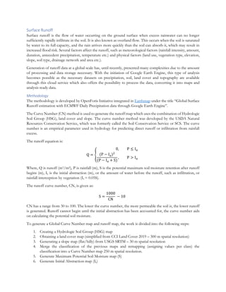
The runoff equation is:
Q = {
0, P ≤ Ia
(P − Ia)2
(P − Ia + S)
, P > Ia
Where, Q is runoff (m3/m2), P is rainfall (m), S is the potential maximum soil moisture retention after runoff
begins (m), Ia is the initial abstraction (m), or the amount of water before the runoff, such as infiltration, or
rainfall interception by vegetation (Ia = 0.05S).
The runoff curve number, CN, is given as:
S =
1000
CN
− 10
CN has a range from 30 to 100. The lower the curve number, the more permeable the soil is, the lower runoff
is generated. Runoff cannot begin until the initial abstraction has been accounted for, the curve number aids
on calculating the potential soil moisture.
To generate a Global Curve Number map and runoff map, the work is divided into the following steps:
1. Creating a Hydrologic Soil Group (HSG) map
2. Obtaining a land cover map (simplified from CCI Land Cover 2019 – 300 m spatial resolution)
3. Generating a slope map (flat/hilly) from USGS SRTM – 30 m spatial resolution
4. Merge the classification of the previous maps and remapping (assigning values per class) the
classification into a Curve Number map 250 m spatial resolution.
5. Generate Maximum Potential Soil Moisture map (S)
6. Generate Initial Abstraction map (Ia)
2. 7. Produce Runoff map
1. Generate a Global Hydrologic Soil Group map
The Hydrologic Soil Group is a classification of the soil into four classes: HSG. A, HSG. B, HSG. C and HSG.
D, from higher to lower infiltration rates. Sandy soils will have a higher infiltration rate than clay soils. The clay
content in the soil can be used to determine the Hydrologic Soil Group it belongs to. The availability in GEE
of a global dataset (SoilGrids) containing clay content in g/kg at 6 standard depths (0, 5, 15, 30, 60 and 100 cm)
allows us to derive the HSG for pixels at 250m resolution.
A script in GEE was generated that calculates the average content of clay in the first 100 centimeters of depth
(using a trapezoidal calculation to calculate a weighted average of clay content for the 0-100 cm depth) and then
reclassified those pixels into one of the 4 HSG classes (A, B, C and D) using this logic as shown in Table 15.
Table 1: Clay content for different Hydrologic Soil Group (HSG) classes
HSG class Clay content C Pixel value
A C < 10% 100
B 10% >= C % < 20% 200
C 20% >= C % < 40% 300
D C >= 40% 400
In the resulting image, the class values for A, B, C, D will be 100, 200, 300 and 400. These values are chosen
so that a unique class combination can be generated with the values of Land Cover (possible values 10, 20, 30,
40, 50 and 60) and slope (0 for flat and 1 for steep) for the Curve Number map.
2. Simplify CCI Land Cover map into 6 Land Cover classes
The most common Land Cover product being used currently is the European Space Agency´s Climate Change
Initiative Land Cover (CCI) dataset. This dataset of 2018 was simplified from the 40 original classes to 6 Land
Cover (LC) classes. The final classes and values are shown in Table 10:
Table 2: Reclassification of land cover classes for simplification
New LC class Pixel value
No vegetation (bare land) 10
Croplands 20
Herbaceous cover 30
Shrubland 40
Tree cover 50
Water cover 60
The mapping (conversion from a CCI class into a simplified LC class) of the classes has been performed using
this logic, as shown in Table 17:
3. CN - Generate Slope map
The slope map was derived from the Shuttle Radar Topography Mission (SRTM) digital elevation data model.
A slope calculation algorithm has been applied to the elevation model and then simplified to classify the pixels
as hilly or flat. If pixel slope gradient > 3%, it is Hilly (value 1), else if pixel slope <= 3%, then it is Flat (value
0).
3. Table 3: Reclassification of 40 landcover classes into six major classes
4. CN - Merging maps and remapping to Curve Number
Once the Hydrologic Soil Group (HSG), Simplified Land Cover (LC) and slope images are generated, as shown
in Table 18, it is possible to combine the values of each pixel to generate new classes of CN.
Table 4: Summary of simplified soil classes, land cover and slope values for estimating curve number
HSG Value Simplified LC Value Slope Value
A 100 No Vegetation 10 Flat 0
B 200 Crops 20 Hilly 1
C 300 Herbaceous 30
D 400 Shrubs 40
Tree 50
Water 60
Using these values (hundreds + tens + units) a unique combination can be generated without fear of
misidentifying pixels, i.e., the combination of HSG, Land Cover and slope can never be equal for two different
combinations. Examples:
HSG. A (100) + Crops (20) + Flat (0) → Class 120
HSG. B (200) + Trees (50) + Hilly (1) → Class 151
This approach to generating unique combinations works if there are less than 10 classes in each different map.
Now CN can be assigned to the values of the pixels for each combination (CN in bold, followed by the
combined class number) as shown in Figure 19:
4. Table 5: Curve numbers for different combinations of land cover, slope and HSG
The Curve Number in water cover areas is assumed to be 100 (all precipitation equals to run-off).
5. Generate Maximum Potential Soil Moisture (S) map
This is a map showing what is the potential absorption of water in the soil. The Soil Moisture (S) Map is
calculated with this expression: Sinches= (1000/CN) – 10
The Soil Moisture is translated from inches to mm by using Smm= Sinches * 25.4
6. Generate Initial Abstraction (Ia) map
This map basically estimates how much it should rain before the runoff starts. Under average conditions, the
Ia is calculated by as 20% of the Maximum Potential Soil Moisture. Ia = 0.2 * S
7. Produce runoff map
To calculate the runoff (Q), an hourly precipitation data (P) from the ECMWF ERA5 Land dataset was used.
The first hour (0) of each day contains the precipitation of the previous 24 hours in the total precipitation band.
To incorporate the previous conditions of the soil, the total precipitation of the 3 previous days was calculated.
For the pixels where the precipitation of the previous days exceeds the 1.5 times of Initial Abstraction, the
Initial Abstraction is reduced to just 30% of the standard Ia to account that the soil might be near capacity (i.e.,
on a day where there has been no rain in the previous days, Ia might be 100 mm, while for a day where the
previous days it has rained 200 mm (above the 1.5*Ia threshold) then the Ia for the single day is reduced to
30mm, after which we consider that runoff starts.
Once this Initial Abstraction (Ia prevcon) is calculated and the condition of P > Ia prevcon is met, then the
runoff can be calculated using the formula:
Q = {
0, P ≤ Ia
(P − Ia)2
(P − Ia + S)
, P > Ia
Limitations:
• This runoff map is generated using a simplified version of the CN method attributed to the because
its empirical origins.
• CN method is restricted to certain geographic regions and land use types. Moreover, it was not
designed to describe the spatial variability of runoff, it only computes the lumped surface runoff for a
given rainfall event from small agricultural, forest, and urban watersheds.
• It should be considered that this CN runoff map is not to be used in naturally bare areas: sandy bare
areas, e.g., the Sahara Desert, result in high runoff which is obviously wrong.
5. GEE scripts for producing layers required for calculating runoff are as follows and link is shown in Annex 1 as
well.
A. Hydrologic Soil Group (HSG)
B. HSG Asset
C. Land Cover Remapping
D. Land Cover Remapping (Asset)
E. Slope Classification
F. Curve Number
G. Curve Number (Asset)
H. Runoff
The input data for estimating surface runoff is shown as Table 20.
Table 20: Input data table for estimating surface runoff
Variable Sensor/Dataset Spatial resolution Extent
Hydrologic Soil Groups SoilGrids 250 m Global
Digital elevation model SRTM 30 m Global
Land cover ESA CCI 300 m Global
Precipitation ECMWF ERA5 LAND ~11 km Global