![Surveying Instruments ,[object Object],[object Object],[object Object],[object Object],[object Object],[object Object],[object Object],[object Object]](data:image/gif;base64,R0lGODlhAQABAIAAAAAAAP///yH5BAEAAAAALAAAAAABAAEAAAIBRAA7)
Recommended
Recommended
More Related Content
What's hot
What's hot (20)
Similar to Plandescil – Surveying
Similar to Plandescil – Surveying (20)
Plandescil – Surveying
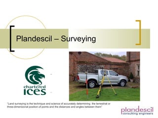
- 1. Plandescil – Surveying “ Land surveying is the technique and science of accurately determining the terrestrial or three-dimensional position of points and the distances and angles between them”
- 5. Topographical Survey – Oxnead Hall
- 6. Site Photographs Oxnead Hall Oxnead Hall Colney Memorial Park Oxnead Hall
- 8. 3D Design & Photographs Liner instalation Gayton Reservoir
- 11. Drawings and Photographs – Blakeney Hotel
- 13. Expert Witness Statement Document