SlideShare a Scribd company logo
1 of 2
Download to read offline
Integrate Enterprise Data
Highway agencies manage and maintain a broad spectrum
of information about their roadways. Often, this information
is distributed throughout the agency in multiple, disparate
systems. For example, the public safety department might
maintain crash data based on mileposts located along the
highway, while the maintenance department may locate
sign and pavement assets based on the distance from a
known point of origin. With Esri Roads and Highways, the
measures associated with data in these external systems
can be kept current and synchronized with edits made to
the LRS, enabling data interoperability and sharing across
all business units.
Esri®
Roads and Highways is a new extension for ArcGIS®
for Desktop and ArcGIS for Server. Agencies responsible for road
and highway maintenance and operations can use this solution to get a unified view of the roadways and related assets
they manage. With Esri Roads and Highways, you can easily overlay data from multiple linear referencing system (LRS)
networks—even when that data is stored in many separate systems across the enterprise. This single, integrated view gives
you the information you need to make better decisions and generate reports.
Esri Roads and Highways
Roads &
Highways
Safety
Repairs
PlanningOther Assets
Pavement
Analyze and Report
Esri Roads and Highways spatially enables business data
from sources other than the geographic information system
(GIS) and integrates it through the LRS. Esri Roads and
Highways, in concert with the ArcGIS platform, can be
used to generate a variety of reports as well as produce
data products and maps that support safety analysis, traffic
congestion studies, and infrastructure maintenance.
These reports and data products can provide government
and public entities with transparency in many facets of
highway-based data such as assets, incidents, and
roadway characteristics.
Web-Based Roadway
Characteristics Editing
With Esri Roads and Highways, you can perform roadway
characteristics editing on any HTML5-enabled web
browser. This allows organizations to extend the reach
of their workflows across the enterprise to include users
and groups without prior GIS software and application
accessibility. These groups can create and edit event data
in a mapcentric experience from within a web browser.
Copyright © 2013 Esri. All rights reserved. Esri, the Esri globe logo, ArcGIS, @esri.com, and esri.com are trademarks, service marks, or
registered marks of Esri in the United States, the European Community, or certain other jurisdictions. Other companies and products
or services mentioned herein may be trademarks, service marks, or registered marks of their respective mark owners.
134264
ESRI3/13rk
Request a free trial at
esri.com/roadsandhighways or
e-mail roadsandhighways@esri.com
for more information.
Maintain Your LRS
Easily visualize and maintain your roadway networks and
associated data. Rule-based location management allows
you to define how event measures and route associations
should react to changes in the LRS, keeping your business
data aligned with roadway network changes.
Quality Control Tools
Esri Roads and Highways includes a complete
QA/QC system with tools for automated and visual review
processes to assess, document, correct, and verify the
overall quality of your spatial data. The tools can be
scheduled to run automatically and are configurable so you
can implement business rules specific to your
organization’s needs.
Workflow Management Tools
Coordinate and track work throughout your organization
using standardized and streamlined workflows. Workflow
management tools provide visibility into day-to-day job
progress, allowing you to track the status and progress of
jobs. A history of actions is automatically recorded for each
job, providing a detailed account of how the job
was completed.

More Related Content

Viewers also liked

Applications of Arc GIS
Applications of Arc GISApplications of Arc GIS
Applications of Arc GISExtraPDFs
 
Intelligent tansportation system
Intelligent tansportation systemIntelligent tansportation system
Intelligent tansportation systemVidya Bharti
 
GIS for traffic management system
GIS for traffic management systemGIS for traffic management system
GIS for traffic management systemSourabh Jain
 
Unique methods of GIS in Transportation
Unique methods of GIS in TransportationUnique methods of GIS in Transportation
Unique methods of GIS in TransportationAndrew Harrison
 
Remote sensing & Gis
Remote sensing & GisRemote sensing & Gis
Remote sensing & Gisgopichand's
 
Application of gis and remote sensing in modern transport system
Application of gis and remote sensing in modern transport systemApplication of gis and remote sensing in modern transport system
Application of gis and remote sensing in modern transport systemSabhapathy Civil
 
Applications of GIS to Logistics and Transportation
Applications of GIS to Logistics and TransportationApplications of GIS to Logistics and Transportation
Applications of GIS to Logistics and Transportationsorbi
 
Network Analysis
Network AnalysisNetwork Analysis
Network Analysisami_01
 
Network Analysis in ArcGIS
Network Analysis in ArcGISNetwork Analysis in ArcGIS
Network Analysis in ArcGISJohn Reiser
 
Intelligent Transportation System
Intelligent Transportation SystemIntelligent Transportation System
Intelligent Transportation SystemGAURAV. H .TANDON
 
Network analysis in gis
Network analysis in gisNetwork analysis in gis
Network analysis in gisstudent
 

Viewers also liked (15)

Applications of Arc GIS
Applications of Arc GISApplications of Arc GIS
Applications of Arc GIS
 
Intelligent tansportation system
Intelligent tansportation systemIntelligent tansportation system
Intelligent tansportation system
 
Gis in transportation
Gis in transportationGis in transportation
Gis in transportation
 
GIS for traffic management system
GIS for traffic management systemGIS for traffic management system
GIS for traffic management system
 
Unique methods of GIS in Transportation
Unique methods of GIS in TransportationUnique methods of GIS in Transportation
Unique methods of GIS in Transportation
 
Remote sensing & Gis
Remote sensing & GisRemote sensing & Gis
Remote sensing & Gis
 
Application of gis and remote sensing in modern transport system
Application of gis and remote sensing in modern transport systemApplication of gis and remote sensing in modern transport system
Application of gis and remote sensing in modern transport system
 
Network analysis & cpm
Network analysis & cpmNetwork analysis & cpm
Network analysis & cpm
 
Applications of GIS to Logistics and Transportation
Applications of GIS to Logistics and TransportationApplications of GIS to Logistics and Transportation
Applications of GIS to Logistics and Transportation
 
Network Analysis
Network AnalysisNetwork Analysis
Network Analysis
 
Aggregates of Concrete
Aggregates of ConcreteAggregates of Concrete
Aggregates of Concrete
 
Network Analysis in ArcGIS
Network Analysis in ArcGISNetwork Analysis in ArcGIS
Network Analysis in ArcGIS
 
Hardened Concrete
Hardened ConcreteHardened Concrete
Hardened Concrete
 
Intelligent Transportation System
Intelligent Transportation SystemIntelligent Transportation System
Intelligent Transportation System
 
Network analysis in gis
Network analysis in gisNetwork analysis in gis
Network analysis in gis
 

Similar to Esri Roads and Highways

Esri Location Analytics: Four Implementation Models
Esri Location Analytics: Four Implementation ModelsEsri Location Analytics: Four Implementation Models
Esri Location Analytics: Four Implementation ModelsEsri
 
ArcGIS for Desktop
ArcGIS for DesktopArcGIS for Desktop
ArcGIS for DesktopEsri
 
ArcGIS Online
ArcGIS OnlineArcGIS Online
ArcGIS OnlineEsri
 
Summer 2013
Summer 2013Summer 2013
Summer 2013Esri
 
Esri News for Petroleum Winter 2013/2014 newsletter
Esri News for Petroleum Winter 2013/2014 newsletterEsri News for Petroleum Winter 2013/2014 newsletter
Esri News for Petroleum Winter 2013/2014 newsletterEsri
 
Esri News for Federal Government Winter 2012/2013 issue
Esri News for Federal Government Winter 2012/2013 issueEsri News for Federal Government Winter 2012/2013 issue
Esri News for Federal Government Winter 2012/2013 issueEsri
 
Portal for ArcGIS
Portal for ArcGISPortal for ArcGIS
Portal for ArcGISEsri
 
GIS for Facilities Overview
GIS for Facilities OverviewGIS for Facilities Overview
GIS for Facilities OverviewEsri
 
Using OGC Standards To Link BI and Spatial
Using OGC Standards To Link BI and SpatialUsing OGC Standards To Link BI and Spatial
Using OGC Standards To Link BI and SpatialMISNet - Integeo SE Asia
 
ArcGIS Online
ArcGIS OnlineArcGIS Online
ArcGIS OnlineEsri
 
FlightlineGeo_ESRI_Newsletter_winter2014
FlightlineGeo_ESRI_Newsletter_winter2014FlightlineGeo_ESRI_Newsletter_winter2014
FlightlineGeo_ESRI_Newsletter_winter2014Devon Humphrey
 
ArcGIS
ArcGISArcGIS
ArcGISEsri
 
A New Pattern for GIS
A New Pattern for GISA New Pattern for GIS
A New Pattern for GISEsri
 
Implementing ArcGIS for Water Utilities
Implementing ArcGIS for Water UtilitiesImplementing ArcGIS for Water Utilities
Implementing ArcGIS for Water UtilitiesEsri
 
Spring 2013
Spring 2013Spring 2013
Spring 2013Esri
 
ArcGIS for the Military--Maritime Operations
ArcGIS for the Military--Maritime OperationsArcGIS for the Military--Maritime Operations
ArcGIS for the Military--Maritime OperationsEsri
 
StreetMap Premium for ArcGIS
StreetMap Premium for ArcGISStreetMap Premium for ArcGIS
StreetMap Premium for ArcGISEsri
 
ArcGIS
ArcGISArcGIS
ArcGISEsri
 

Similar to Esri Roads and Highways (20)

Esri Location Analytics: Four Implementation Models
Esri Location Analytics: Four Implementation ModelsEsri Location Analytics: Four Implementation Models
Esri Location Analytics: Four Implementation Models
 
ArcGIS for Desktop
ArcGIS for DesktopArcGIS for Desktop
ArcGIS for Desktop
 
ArcGIS Online
ArcGIS OnlineArcGIS Online
ArcGIS Online
 
Summer 2013
Summer 2013Summer 2013
Summer 2013
 
Esri News for Petroleum Winter 2013/2014 newsletter
Esri News for Petroleum Winter 2013/2014 newsletterEsri News for Petroleum Winter 2013/2014 newsletter
Esri News for Petroleum Winter 2013/2014 newsletter
 
Esri News for Federal Government Winter 2012/2013 issue
Esri News for Federal Government Winter 2012/2013 issueEsri News for Federal Government Winter 2012/2013 issue
Esri News for Federal Government Winter 2012/2013 issue
 
Portal for ArcGIS
Portal for ArcGISPortal for ArcGIS
Portal for ArcGIS
 
GIS for Facilities Overview
GIS for Facilities OverviewGIS for Facilities Overview
GIS for Facilities Overview
 
Using OGC Standards To Link BI and Spatial
Using OGC Standards To Link BI and SpatialUsing OGC Standards To Link BI and Spatial
Using OGC Standards To Link BI and Spatial
 
ODOT PR
ODOT PRODOT PR
ODOT PR
 
ArcGIS Online
ArcGIS OnlineArcGIS Online
ArcGIS Online
 
FlightlineGeo_ESRI_Newsletter_winter2014
FlightlineGeo_ESRI_Newsletter_winter2014FlightlineGeo_ESRI_Newsletter_winter2014
FlightlineGeo_ESRI_Newsletter_winter2014
 
ArcGIS
ArcGISArcGIS
ArcGIS
 
A New Pattern for GIS
A New Pattern for GISA New Pattern for GIS
A New Pattern for GIS
 
Implementing ArcGIS for Water Utilities
Implementing ArcGIS for Water UtilitiesImplementing ArcGIS for Water Utilities
Implementing ArcGIS for Water Utilities
 
Situational awareness
Situational awarenessSituational awareness
Situational awareness
 
Spring 2013
Spring 2013Spring 2013
Spring 2013
 
ArcGIS for the Military--Maritime Operations
ArcGIS for the Military--Maritime OperationsArcGIS for the Military--Maritime Operations
ArcGIS for the Military--Maritime Operations
 
StreetMap Premium for ArcGIS
StreetMap Premium for ArcGISStreetMap Premium for ArcGIS
StreetMap Premium for ArcGIS
 
ArcGIS
ArcGISArcGIS
ArcGIS
 

More from Esri

Aena Aeropuerto Adolfo Suárez-Barajas crea potentes aplicaciones para sus cli...
Aena Aeropuerto Adolfo Suárez-Barajas crea potentes aplicaciones para sus cli...Aena Aeropuerto Adolfo Suárez-Barajas crea potentes aplicaciones para sus cli...
Aena Aeropuerto Adolfo Suárez-Barajas crea potentes aplicaciones para sus cli...Esri
 
Plataforma Smart City de Móstoles
Plataforma Smart City de MóstolesPlataforma Smart City de Móstoles
Plataforma Smart City de MóstolesEsri
 
ArcGIS Online para Organizaciones
ArcGIS Online para OrganizacionesArcGIS Online para Organizaciones
ArcGIS Online para OrganizacionesEsri
 
Molina de Segura se convierte en una smart city
Molina de Segura se convierte en una smart cityMolina de Segura se convierte en una smart city
Molina de Segura se convierte en una smart cityEsri
 
GIS-Based Web Services Provide Rapid Analysis and Dissemination of Maritime Data
GIS-Based Web Services Provide Rapid Analysis and Dissemination of Maritime DataGIS-Based Web Services Provide Rapid Analysis and Dissemination of Maritime Data
GIS-Based Web Services Provide Rapid Analysis and Dissemination of Maritime DataEsri
 
An Effective Tool for Drinking Water Protection
An Effective Tool for Drinking Water ProtectionAn Effective Tool for Drinking Water Protection
An Effective Tool for Drinking Water ProtectionEsri
 
GeoCollector for ArcPad
GeoCollector for ArcPadGeoCollector for ArcPad
GeoCollector for ArcPadEsri
 
GeoCollector for ArcGIS for Windows Mobile
GeoCollector for ArcGIS for Windows MobileGeoCollector for ArcGIS for Windows Mobile
GeoCollector for ArcGIS for Windows MobileEsri
 
Data Appliance for ArcGIS
Data Appliance for ArcGISData Appliance for ArcGIS
Data Appliance for ArcGISEsri
 
Esri and BlackBridge
Esri and BlackBridgeEsri and BlackBridge
Esri and BlackBridgeEsri
 
GeoPlanner for ArcGIS
GeoPlanner for ArcGISGeoPlanner for ArcGIS
GeoPlanner for ArcGISEsri
 
Esri and AccuWeather
Esri and AccuWeatherEsri and AccuWeather
Esri and AccuWeatherEsri
 
Esri and Airbus Defense & Space
Esri and Airbus Defense & SpaceEsri and Airbus Defense & Space
Esri and Airbus Defense & SpaceEsri
 
Esri US Data Fact Sheet
Esri US Data Fact SheetEsri US Data Fact Sheet
Esri US Data Fact SheetEsri
 
ArcGIS for Server on Microsoft Azure Jumpstart
ArcGIS for Server on Microsoft Azure JumpstartArcGIS for Server on Microsoft Azure Jumpstart
ArcGIS for Server on Microsoft Azure JumpstartEsri
 
Esri Geoportal Server
Esri Geoportal ServerEsri Geoportal Server
Esri Geoportal ServerEsri
 
ArcGIS GeoEvent Extension for Server
ArcGIS GeoEvent Extension for ServerArcGIS GeoEvent Extension for Server
ArcGIS GeoEvent Extension for ServerEsri
 
The NATO Core Geographic Services System
The NATO Core Geographic Services SystemThe NATO Core Geographic Services System
The NATO Core Geographic Services SystemEsri
 
ArcGIS for Desktop Tips and Shortcuts
ArcGIS for Desktop Tips and ShortcutsArcGIS for Desktop Tips and Shortcuts
ArcGIS for Desktop Tips and ShortcutsEsri
 
ArcGIS: A Platform for Intelligent 3D Imagery
ArcGIS: A Platform for Intelligent 3D ImageryArcGIS: A Platform for Intelligent 3D Imagery
ArcGIS: A Platform for Intelligent 3D ImageryEsri
 

More from Esri (20)

Aena Aeropuerto Adolfo Suárez-Barajas crea potentes aplicaciones para sus cli...
Aena Aeropuerto Adolfo Suárez-Barajas crea potentes aplicaciones para sus cli...Aena Aeropuerto Adolfo Suárez-Barajas crea potentes aplicaciones para sus cli...
Aena Aeropuerto Adolfo Suárez-Barajas crea potentes aplicaciones para sus cli...
 
Plataforma Smart City de Móstoles
Plataforma Smart City de MóstolesPlataforma Smart City de Móstoles
Plataforma Smart City de Móstoles
 
ArcGIS Online para Organizaciones
ArcGIS Online para OrganizacionesArcGIS Online para Organizaciones
ArcGIS Online para Organizaciones
 
Molina de Segura se convierte en una smart city
Molina de Segura se convierte en una smart cityMolina de Segura se convierte en una smart city
Molina de Segura se convierte en una smart city
 
GIS-Based Web Services Provide Rapid Analysis and Dissemination of Maritime Data
GIS-Based Web Services Provide Rapid Analysis and Dissemination of Maritime DataGIS-Based Web Services Provide Rapid Analysis and Dissemination of Maritime Data
GIS-Based Web Services Provide Rapid Analysis and Dissemination of Maritime Data
 
An Effective Tool for Drinking Water Protection
An Effective Tool for Drinking Water ProtectionAn Effective Tool for Drinking Water Protection
An Effective Tool for Drinking Water Protection
 
GeoCollector for ArcPad
GeoCollector for ArcPadGeoCollector for ArcPad
GeoCollector for ArcPad
 
GeoCollector for ArcGIS for Windows Mobile
GeoCollector for ArcGIS for Windows MobileGeoCollector for ArcGIS for Windows Mobile
GeoCollector for ArcGIS for Windows Mobile
 
Data Appliance for ArcGIS
Data Appliance for ArcGISData Appliance for ArcGIS
Data Appliance for ArcGIS
 
Esri and BlackBridge
Esri and BlackBridgeEsri and BlackBridge
Esri and BlackBridge
 
GeoPlanner for ArcGIS
GeoPlanner for ArcGISGeoPlanner for ArcGIS
GeoPlanner for ArcGIS
 
Esri and AccuWeather
Esri and AccuWeatherEsri and AccuWeather
Esri and AccuWeather
 
Esri and Airbus Defense & Space
Esri and Airbus Defense & SpaceEsri and Airbus Defense & Space
Esri and Airbus Defense & Space
 
Esri US Data Fact Sheet
Esri US Data Fact SheetEsri US Data Fact Sheet
Esri US Data Fact Sheet
 
ArcGIS for Server on Microsoft Azure Jumpstart
ArcGIS for Server on Microsoft Azure JumpstartArcGIS for Server on Microsoft Azure Jumpstart
ArcGIS for Server on Microsoft Azure Jumpstart
 
Esri Geoportal Server
Esri Geoportal ServerEsri Geoportal Server
Esri Geoportal Server
 
ArcGIS GeoEvent Extension for Server
ArcGIS GeoEvent Extension for ServerArcGIS GeoEvent Extension for Server
ArcGIS GeoEvent Extension for Server
 
The NATO Core Geographic Services System
The NATO Core Geographic Services SystemThe NATO Core Geographic Services System
The NATO Core Geographic Services System
 
ArcGIS for Desktop Tips and Shortcuts
ArcGIS for Desktop Tips and ShortcutsArcGIS for Desktop Tips and Shortcuts
ArcGIS for Desktop Tips and Shortcuts
 
ArcGIS: A Platform for Intelligent 3D Imagery
ArcGIS: A Platform for Intelligent 3D ImageryArcGIS: A Platform for Intelligent 3D Imagery
ArcGIS: A Platform for Intelligent 3D Imagery
 

Recently uploaded

The Future of Software Development - Devin AI Innovative Approach.pdf
The Future of Software Development - Devin AI Innovative Approach.pdfThe Future of Software Development - Devin AI Innovative Approach.pdf
The Future of Software Development - Devin AI Innovative Approach.pdfSeasiaInfotech2
 
"Debugging python applications inside k8s environment", Andrii Soldatenko
"Debugging python applications inside k8s environment", Andrii Soldatenko"Debugging python applications inside k8s environment", Andrii Soldatenko
"Debugging python applications inside k8s environment", Andrii SoldatenkoFwdays
 
Story boards and shot lists for my a level piece
Story boards and shot lists for my a level pieceStory boards and shot lists for my a level piece
Story boards and shot lists for my a level piececharlottematthew16
 
Integration and Automation in Practice: CI/CD in Mule Integration and Automat...
Integration and Automation in Practice: CI/CD in Mule Integration and Automat...Integration and Automation in Practice: CI/CD in Mule Integration and Automat...
Integration and Automation in Practice: CI/CD in Mule Integration and Automat...Patryk Bandurski
 
Designing IA for AI - Information Architecture Conference 2024
Designing IA for AI - Information Architecture Conference 2024Designing IA for AI - Information Architecture Conference 2024
Designing IA for AI - Information Architecture Conference 2024Enterprise Knowledge
 
Vertex AI Gemini Prompt Engineering Tips
Vertex AI Gemini Prompt Engineering TipsVertex AI Gemini Prompt Engineering Tips
Vertex AI Gemini Prompt Engineering TipsMiki Katsuragi
 
Dev Dives: Streamline document processing with UiPath Studio Web
Dev Dives: Streamline document processing with UiPath Studio WebDev Dives: Streamline document processing with UiPath Studio Web
Dev Dives: Streamline document processing with UiPath Studio WebUiPathCommunity
 
Kotlin Multiplatform & Compose Multiplatform - Starter kit for pragmatics
Kotlin Multiplatform & Compose Multiplatform - Starter kit for pragmaticsKotlin Multiplatform & Compose Multiplatform - Starter kit for pragmatics
Kotlin Multiplatform & Compose Multiplatform - Starter kit for pragmaticscarlostorres15106
 
My INSURER PTE LTD - Insurtech Innovation Award 2024
My INSURER PTE LTD - Insurtech Innovation Award 2024My INSURER PTE LTD - Insurtech Innovation Award 2024
My INSURER PTE LTD - Insurtech Innovation Award 2024The Digital Insurer
 
Ensuring Technical Readiness For Copilot in Microsoft 365
Ensuring Technical Readiness For Copilot in Microsoft 365Ensuring Technical Readiness For Copilot in Microsoft 365
Ensuring Technical Readiness For Copilot in Microsoft 3652toLead Limited
 
Developer Data Modeling Mistakes: From Postgres to NoSQL
Developer Data Modeling Mistakes: From Postgres to NoSQLDeveloper Data Modeling Mistakes: From Postgres to NoSQL
Developer Data Modeling Mistakes: From Postgres to NoSQLScyllaDB
 
Training state-of-the-art general text embedding
Training state-of-the-art general text embeddingTraining state-of-the-art general text embedding
Training state-of-the-art general text embeddingZilliz
 
AI as an Interface for Commercial Buildings
AI as an Interface for Commercial BuildingsAI as an Interface for Commercial Buildings
AI as an Interface for Commercial BuildingsMemoori
 
CloudStudio User manual (basic edition):
CloudStudio User manual (basic edition):CloudStudio User manual (basic edition):
CloudStudio User manual (basic edition):comworks
 
Powerpoint exploring the locations used in television show Time Clash
Powerpoint exploring the locations used in television show Time ClashPowerpoint exploring the locations used in television show Time Clash
Powerpoint exploring the locations used in television show Time Clashcharlottematthew16
 
Anypoint Exchange: It’s Not Just a Repo!
Anypoint Exchange: It’s Not Just a Repo!Anypoint Exchange: It’s Not Just a Repo!
Anypoint Exchange: It’s Not Just a Repo!Manik S Magar
 
Streamlining Python Development: A Guide to a Modern Project Setup
Streamlining Python Development: A Guide to a Modern Project SetupStreamlining Python Development: A Guide to a Modern Project Setup
Streamlining Python Development: A Guide to a Modern Project SetupFlorian Wilhelm
 
My Hashitalk Indonesia April 2024 Presentation
My Hashitalk Indonesia April 2024 PresentationMy Hashitalk Indonesia April 2024 Presentation
My Hashitalk Indonesia April 2024 PresentationRidwan Fadjar
 
WordPress Websites for Engineers: Elevate Your Brand
WordPress Websites for Engineers: Elevate Your BrandWordPress Websites for Engineers: Elevate Your Brand
WordPress Websites for Engineers: Elevate Your Brandgvaughan
 

Recently uploaded (20)

The Future of Software Development - Devin AI Innovative Approach.pdf
The Future of Software Development - Devin AI Innovative Approach.pdfThe Future of Software Development - Devin AI Innovative Approach.pdf
The Future of Software Development - Devin AI Innovative Approach.pdf
 
"Debugging python applications inside k8s environment", Andrii Soldatenko
"Debugging python applications inside k8s environment", Andrii Soldatenko"Debugging python applications inside k8s environment", Andrii Soldatenko
"Debugging python applications inside k8s environment", Andrii Soldatenko
 
Story boards and shot lists for my a level piece
Story boards and shot lists for my a level pieceStory boards and shot lists for my a level piece
Story boards and shot lists for my a level piece
 
Integration and Automation in Practice: CI/CD in Mule Integration and Automat...
Integration and Automation in Practice: CI/CD in Mule Integration and Automat...Integration and Automation in Practice: CI/CD in Mule Integration and Automat...
Integration and Automation in Practice: CI/CD in Mule Integration and Automat...
 
Designing IA for AI - Information Architecture Conference 2024
Designing IA for AI - Information Architecture Conference 2024Designing IA for AI - Information Architecture Conference 2024
Designing IA for AI - Information Architecture Conference 2024
 
Vertex AI Gemini Prompt Engineering Tips
Vertex AI Gemini Prompt Engineering TipsVertex AI Gemini Prompt Engineering Tips
Vertex AI Gemini Prompt Engineering Tips
 
Dev Dives: Streamline document processing with UiPath Studio Web
Dev Dives: Streamline document processing with UiPath Studio WebDev Dives: Streamline document processing with UiPath Studio Web
Dev Dives: Streamline document processing with UiPath Studio Web
 
Kotlin Multiplatform & Compose Multiplatform - Starter kit for pragmatics
Kotlin Multiplatform & Compose Multiplatform - Starter kit for pragmaticsKotlin Multiplatform & Compose Multiplatform - Starter kit for pragmatics
Kotlin Multiplatform & Compose Multiplatform - Starter kit for pragmatics
 
My INSURER PTE LTD - Insurtech Innovation Award 2024
My INSURER PTE LTD - Insurtech Innovation Award 2024My INSURER PTE LTD - Insurtech Innovation Award 2024
My INSURER PTE LTD - Insurtech Innovation Award 2024
 
Ensuring Technical Readiness For Copilot in Microsoft 365
Ensuring Technical Readiness For Copilot in Microsoft 365Ensuring Technical Readiness For Copilot in Microsoft 365
Ensuring Technical Readiness For Copilot in Microsoft 365
 
Developer Data Modeling Mistakes: From Postgres to NoSQL
Developer Data Modeling Mistakes: From Postgres to NoSQLDeveloper Data Modeling Mistakes: From Postgres to NoSQL
Developer Data Modeling Mistakes: From Postgres to NoSQL
 
Training state-of-the-art general text embedding
Training state-of-the-art general text embeddingTraining state-of-the-art general text embedding
Training state-of-the-art general text embedding
 
AI as an Interface for Commercial Buildings
AI as an Interface for Commercial BuildingsAI as an Interface for Commercial Buildings
AI as an Interface for Commercial Buildings
 
CloudStudio User manual (basic edition):
CloudStudio User manual (basic edition):CloudStudio User manual (basic edition):
CloudStudio User manual (basic edition):
 
Powerpoint exploring the locations used in television show Time Clash
Powerpoint exploring the locations used in television show Time ClashPowerpoint exploring the locations used in television show Time Clash
Powerpoint exploring the locations used in television show Time Clash
 
Anypoint Exchange: It’s Not Just a Repo!
Anypoint Exchange: It’s Not Just a Repo!Anypoint Exchange: It’s Not Just a Repo!
Anypoint Exchange: It’s Not Just a Repo!
 
Streamlining Python Development: A Guide to a Modern Project Setup
Streamlining Python Development: A Guide to a Modern Project SetupStreamlining Python Development: A Guide to a Modern Project Setup
Streamlining Python Development: A Guide to a Modern Project Setup
 
My Hashitalk Indonesia April 2024 Presentation
My Hashitalk Indonesia April 2024 PresentationMy Hashitalk Indonesia April 2024 Presentation
My Hashitalk Indonesia April 2024 Presentation
 
WordPress Websites for Engineers: Elevate Your Brand
WordPress Websites for Engineers: Elevate Your BrandWordPress Websites for Engineers: Elevate Your Brand
WordPress Websites for Engineers: Elevate Your Brand
 
E-Vehicle_Hacking_by_Parul Sharma_null_owasp.pptx
E-Vehicle_Hacking_by_Parul Sharma_null_owasp.pptxE-Vehicle_Hacking_by_Parul Sharma_null_owasp.pptx
E-Vehicle_Hacking_by_Parul Sharma_null_owasp.pptx
 

Esri Roads and Highways

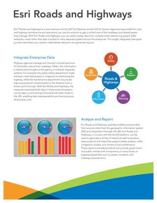
  • 1. Integrate Enterprise Data Highway agencies manage and maintain a broad spectrum of information about their roadways. Often, this information is distributed throughout the agency in multiple, disparate systems. For example, the public safety department might maintain crash data based on mileposts located along the highway, while the maintenance department may locate sign and pavement assets based on the distance from a known point of origin. With Esri Roads and Highways, the measures associated with data in these external systems can be kept current and synchronized with edits made to the LRS, enabling data interoperability and sharing across all business units. Esri® Roads and Highways is a new extension for ArcGIS® for Desktop and ArcGIS for Server. Agencies responsible for road and highway maintenance and operations can use this solution to get a unified view of the roadways and related assets they manage. With Esri Roads and Highways, you can easily overlay data from multiple linear referencing system (LRS) networks—even when that data is stored in many separate systems across the enterprise. This single, integrated view gives you the information you need to make better decisions and generate reports. Esri Roads and Highways Roads & Highways Safety Repairs PlanningOther Assets Pavement Analyze and Report Esri Roads and Highways spatially enables business data from sources other than the geographic information system (GIS) and integrates it through the LRS. Esri Roads and Highways, in concert with the ArcGIS platform, can be used to generate a variety of reports as well as produce data products and maps that support safety analysis, traffic congestion studies, and infrastructure maintenance. These reports and data products can provide government and public entities with transparency in many facets of highway-based data such as assets, incidents, and roadway characteristics.
  • 2. Web-Based Roadway Characteristics Editing With Esri Roads and Highways, you can perform roadway characteristics editing on any HTML5-enabled web browser. This allows organizations to extend the reach of their workflows across the enterprise to include users and groups without prior GIS software and application accessibility. These groups can create and edit event data in a mapcentric experience from within a web browser. Copyright © 2013 Esri. All rights reserved. Esri, the Esri globe logo, ArcGIS, @esri.com, and esri.com are trademarks, service marks, or registered marks of Esri in the United States, the European Community, or certain other jurisdictions. Other companies and products or services mentioned herein may be trademarks, service marks, or registered marks of their respective mark owners. 134264 ESRI3/13rk Request a free trial at esri.com/roadsandhighways or e-mail roadsandhighways@esri.com for more information. Maintain Your LRS Easily visualize and maintain your roadway networks and associated data. Rule-based location management allows you to define how event measures and route associations should react to changes in the LRS, keeping your business data aligned with roadway network changes. Quality Control Tools Esri Roads and Highways includes a complete QA/QC system with tools for automated and visual review processes to assess, document, correct, and verify the overall quality of your spatial data. The tools can be scheduled to run automatically and are configurable so you can implement business rules specific to your organization’s needs. Workflow Management Tools Coordinate and track work throughout your organization using standardized and streamlined workflows. Workflow management tools provide visibility into day-to-day job progress, allowing you to track the status and progress of jobs. A history of actions is automatically recorded for each job, providing a detailed account of how the job was completed.