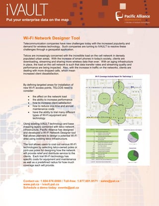
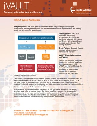
Put your enterprise data on the map


         Wi-Fi Network Designer Tool
         Telecommunication companies have new challenges today with the increased popularity and
         demand for wireless technology. Such companies are turning to iVAULT to resolve these
         challenges through a geospatial application.

         Telcos are increasingly concerned with the incredible load on the cell network in densely
         populated urban areas. With the increase of smart phones in today's society, clients are
         downloading, streaming and sharing more wireless data than ever. With an aging infrastructure
         in place, the load on the cell network is such that data transfer rates and streaming quality and
         performance are being impacted. Also, with the increase in traffic on the networks, clients are
         dealing with more dropped calls, which mean
         increased client dissatisfaction.


         By defining targeted areas for installation of
         new Wi-Fi access points, TELCOS need to
         consider:

                 the affect on the network load
                 the ability to increase performance
                 how to increase client satisfaction
                 how to reduce one-time and annual
                 maintenance costs
                 have the ability to trial many different
                 types of Wi-Fi equipment and
                 technology

         Using existing iVAULT technology and base
         mapping layers combined with telco network
         infrastructure, Pacific Alliance has designed
         and developed a Wi-Fi Network Designer tool
         that allows planners to design a potential Wi-Fi
         area using existing telco infrastructure.

         The tool allows users to cost out various Wi-Fi
         technologies by selecting telco-owned poles or
         joint-use poles for designing how the network
         will provide relief and distribute service to the
         clients. Each trial Wi-Fi technology has
         specific costs for equipment and maintenance
         as well as a predefined radius for how much
         coverage each will provide.


         Contact us: 1.604.676.6000 / Toll-free: 1.877.691.9171  sales@pat.ca 
         www.pat.ca  ivault.pat.ca
         Schedule a demo today: events@pat.ca
Put your enterprise data on the map


         iVAULT System Architecture


         Easy Integration: iVAULT’s open architecture makes it easy to design and configure
         components. Leverage existing data sets and systems to minimize implementation and training
         costs. No programming skills required.

                                                                        Open Approach: iVAULT is
                                                                        compatible with leading
                                                                        technologies: ArcGIS Server,
                                                                        MapGuide, Microsoft SQL Server
                                                                        and Oracle—allowing you to use
                                                                        your data and systems in their
                                                                        existing structure.

                                                                        Cross-Platform Support: Access
                                                                        your data with any industry-
                                                                        standard web-browser.

                                                                        iVAULT driven by technology
                                                                        and Passion !

                                                                        iVAULT was designed to provide
                                                                        simplicity for business workflows.
                                                                        Since its inception in 2002,
                                                                        iVAULT has migrated through the
                                                                        various iterations of software
                                                                        technology in the market to
                                                                        become one of the most
                                                                        configurable and open web
         mapping applications available.

         The Pacific Alliance team has worked hard over the years to ensure that we understand what our
         users want in a web mapping application. With its roots in telecommunications, iVAULT now
         serves a variety of business sectors from oil & gas to local government. This evolution has
         required the team to focus on understanding how each user requirement can be implemented in a
         generic way, while keeping the simplicity of use.

         From scalable architecture to easier navigation for non GIS users, we believe that iVAULT
         provides great value to our user base. Our clients benefit by reducing their investment of
         understanding how to build a spatial portal, which leaves them to focus on their business and
         reduce their costs. This has been proven time and time again, and as a result our long term
         clients now have some of the best quality enterprise data in the market.


         Contact us: 1.604.676.6000 / Toll-free: 1.877.691.9171  sales@pat.ca 
         www.pat.ca  ivault.pat.ca
         Schedule a demo today: events@pat.ca
Put your enterprise data on the map


         About Pacific Alliance Technologies


         Pacific Alliance Technologies provides proven geospatial solutions for companies to manage,
         query and analyze spatial information. Whether you are just starting in GIS or using a solution
         from Autodesk, Bentley, Google or ESRI, Pacific Alliance provides a range of GIS services – from
         helping you create and manage your data workflows, creating and setting up web mapping sites,
         to customizing your GIS with other systems. Drawing on our depth of GIS experience (120
         combined years), you can rely on our total commitment to providing you the best combination of
         software and services. We help turn your projects and ideas into successful implementations!


         Contact us: 1.604.676.6000 / Toll-free: 1.877.691.9171  sales@pat.ca 
         www.pat.ca  ivault.pat.ca
         Schedule a demo today: events@pat.ca

Web GIS Application: IVAULT Wi-Fi

  • 1.
    Put your enterprisedata on the map Wi-Fi Network Designer Tool Telecommunication companies have new challenges today with the increased popularity and demand for wireless technology. Such companies are turning to iVAULT to resolve these challenges through a geospatial application. Telcos are increasingly concerned with the incredible load on the cell network in densely populated urban areas. With the increase of smart phones in today's society, clients are downloading, streaming and sharing more wireless data than ever. With an aging infrastructure in place, the load on the cell network is such that data transfer rates and streaming quality and performance are being impacted. Also, with the increase in traffic on the networks, clients are dealing with more dropped calls, which mean increased client dissatisfaction. By defining targeted areas for installation of new Wi-Fi access points, TELCOS need to consider: the affect on the network load the ability to increase performance how to increase client satisfaction how to reduce one-time and annual maintenance costs have the ability to trial many different types of Wi-Fi equipment and technology Using existing iVAULT technology and base mapping layers combined with telco network infrastructure, Pacific Alliance has designed and developed a Wi-Fi Network Designer tool that allows planners to design a potential Wi-Fi area using existing telco infrastructure. The tool allows users to cost out various Wi-Fi technologies by selecting telco-owned poles or joint-use poles for designing how the network will provide relief and distribute service to the clients. Each trial Wi-Fi technology has specific costs for equipment and maintenance as well as a predefined radius for how much coverage each will provide. Contact us: 1.604.676.6000 / Toll-free: 1.877.691.9171  sales@pat.ca  www.pat.ca  ivault.pat.ca Schedule a demo today: events@pat.ca
  • 2.
    Put your enterprisedata on the map iVAULT System Architecture Easy Integration: iVAULT’s open architecture makes it easy to design and configure components. Leverage existing data sets and systems to minimize implementation and training costs. No programming skills required. Open Approach: iVAULT is compatible with leading technologies: ArcGIS Server, MapGuide, Microsoft SQL Server and Oracle—allowing you to use your data and systems in their existing structure. Cross-Platform Support: Access your data with any industry- standard web-browser. iVAULT driven by technology and Passion ! iVAULT was designed to provide simplicity for business workflows. Since its inception in 2002, iVAULT has migrated through the various iterations of software technology in the market to become one of the most configurable and open web mapping applications available. The Pacific Alliance team has worked hard over the years to ensure that we understand what our users want in a web mapping application. With its roots in telecommunications, iVAULT now serves a variety of business sectors from oil & gas to local government. This evolution has required the team to focus on understanding how each user requirement can be implemented in a generic way, while keeping the simplicity of use. From scalable architecture to easier navigation for non GIS users, we believe that iVAULT provides great value to our user base. Our clients benefit by reducing their investment of understanding how to build a spatial portal, which leaves them to focus on their business and reduce their costs. This has been proven time and time again, and as a result our long term clients now have some of the best quality enterprise data in the market. Contact us: 1.604.676.6000 / Toll-free: 1.877.691.9171  sales@pat.ca  www.pat.ca  ivault.pat.ca Schedule a demo today: events@pat.ca
  • 3.
    Put your enterprisedata on the map About Pacific Alliance Technologies Pacific Alliance Technologies provides proven geospatial solutions for companies to manage, query and analyze spatial information. Whether you are just starting in GIS or using a solution from Autodesk, Bentley, Google or ESRI, Pacific Alliance provides a range of GIS services – from helping you create and manage your data workflows, creating and setting up web mapping sites, to customizing your GIS with other systems. Drawing on our depth of GIS experience (120 combined years), you can rely on our total commitment to providing you the best combination of software and services. We help turn your projects and ideas into successful implementations! Contact us: 1.604.676.6000 / Toll-free: 1.877.691.9171  sales@pat.ca  www.pat.ca  ivault.pat.ca Schedule a demo today: events@pat.ca