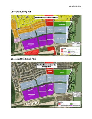
MarvelousEcheng
Writing Sample of the Viridian Commons Parcel
This writing sample focuses on a review and recommendation for the redevelopment of
the Viridian Parcel.
Location and Size
The location for the project is at the intersection of Viridian Park Lane and Collins Road
in Arlington, Texas. Arlington, Texas is the third largest city, in terms of population, within
the Dallas-Fort Worth ‘Metroplex’. The site consists of two parcels, the larger of which
being 44.4 acres and the smaller being 23.4 acres. The two parcels are divided by the
Blue Lake Boulevard.
Terrain
The terrain of the site contains a gently sloping plain that leads runoff water south to the
catchment basins along the Trinity River. The terrain of the site was sculped from the
existing use of the site which was used as a brownfield.
History
The original settlement of the DFW region happened in the immediate vicinity of the
Viridian Development. For example, the original treaty of Anglo-American settlers with
Native American tribes was done within the Viridian Development at Bird’s Fort. The first
American/Texan settlers to the region settled directly adjacent to Calloway’s Cemetery
directly north of the site. Aside from the area’s pertinence to human habitation, along the
bluff protruding from Calloway Cemetery Road is an archaeologically rich site that
contains fossils from various pre-historic eras. In the Early 20th century, before the river
was tamed, ran a steamboat service between Dallas and Fort Worth which would have
brought many travelers through the ViridianDevelopment.
Surrounding Areas
Directly to the east there is a neighborhood by the name of ‘Viridian.’ This neighborhood
is still under construction and contains a wide variety of housing stock and local amenities
to its residents. To the west is an active landfill. To the south is the Trinity River. Many
years ago, the mighty river was tamed by a continuous system of levies that confines the
river to its current location. To the North, are areas of extreme environmental degradation.
The area which was first settled by Anglo-Americans has now turned into a waste dump.
For instance, directly southeast of Calloway’s cemetery, is a dumpsite that has been used
for years as a site where people illegally dump old roofing shingles. What was once the
first area in North Texas settled by early Americans and Texans, has now turned into a
garbage dump and is wholly forgotten by our north Texan communities and residents.
MarvelousEcheng
Transport Accessibilities
At this point and time, the only access to this site is exclusively done along Highway 157,
or North Collins Road. The City of Arlington’s Master Thoroughfare Development Plan
classifies this roadway as a major arterial with an anticipated traffic volume of anywhere
from 15,000-50,000 vehicle trips. The Right-Of-Way for this roadway is well over the 120’
minimum for the Major Arterial classification. According to the Master Thoroughfare
Development Plan, the city is not planning to widen North Collins, north of NE Green Oaks
Boulevard, in its current capacity soon. The anticipated traffic volume in 2040 is over
67,000, which would potentially make it the busiest street in the whole municipality of
Arlington. Off this main road is the entry way to the Viridian neighborhood. Entrance to
the neighborhood from N Collins is done on three access routes, Viridian Park Lane, Blue
Lake Boulevard, and Birds Fort Trail. All three of these routes are classified by the city as
Local Roads.
Purpose
The purpose of the site plan will be to create a regional hub of employment, commercial,
residential, and recreational opportunities. This will expand business opportunities that
rely on multi-modal transit connections. Mixed-use neighborhood that encourages
pedestrian activity and serves residents and visitors are preferred. This district will attract
office buildings; retail, dining, drinking, and lodging establishments; and leisure facilities.
Scope
The scope of the project will be focusing on the two parcels that surround Blue Lake
Boulevard. Our plan divides the B1 strip of land from Viridian Park Lane to Bird’s Fort
Trail, into two sections, an east section, and a west section. This is done to create a main
street environment which will act as the focal point of the development. This main street
is to be called, ViridianWay Boulevard. To the south of Blue Lake Boulevard, the two new
areas will be zoned as Neighborhood Mixed-Use. With emphasis on creating a first floor-
retail and mid-rise development consisting of exclusively multi-family residential housing.
To the north of Blue Lake Boulevard, and west sideof ViridianWay, the area will be zoned
as Regional Mixed-use. This is aimed to create a new regional hub of employment. This
hub will be dependent on the vehicular flow of traffic along Highway 157. In order to better
provide access to the site. A rail station must be created along the Trinity Railway Express
line that runs directly north of Bird’s Fort Trail. By adding a rail station to the existing
transportation network, Viridian Commons and the Viridian Neighborhood could become
a true multi-modal neighborhood with increased opportunities for mobility for not just the
Viridian residents, but for all of Arlington. To the east of Viridian Way and North of Blue
Lake Boulevard, will be exclusively Neighborhood Mixed-Use development. For all the
properties, we are seeking a 14-foot setback, which satisfies all setback requirements
MarvelousEcheng
which demand a minimum 10-foot setback. In addition to these zones, we will be seeking
a downtown neighborhood overlay in order to allow for 45-degree angle head in parking.
This type of head in parking allows for increased parking along ViridianWay which would
accommodate retail traffic along the main street. Head in parking also allows for increased
uses, for instance on weekends the main street could be repurposed into a farmer’s
marketplace where future tenants could set up stands in the repurposed parking spaces.
See attached photos below.
Market Condition
The city of Arlington was found during the 19th century. Ever since that period, Arlington
has faced a blooming population growth that has reached 396,394 (2018). Arlington is
one of the largest cities noted today that is to be in Texas. Of the total population 26.9
percent belongs to the age group 35-54 which means the city has more middle-aged
adults than persons of younger or older age groups. There are approximately 147,407
households that are existent on the city with an estimated average size of 3 persons per
household.
Demand
The site area is lacking in multi-modal transportation. If the rail link for the trains were
more utilized there will be possibilities for multi-modal transportation. Which includes
biking, public transportation and more. The purpose is to redevelop the parcel to where it
encourages a multi-modal transportation.
Codes
2.3.12 Neighborhood Mixed-Use
2.3.13 Regional Mixed-Use
2.4.3 Downtown Neighborhood Overlay
MarvelousEcheng
Conceptual Zoning Plan
Conceptual Subdivision Plan
MarvelousEcheng
Supporting Materials
Plano Legacy West provides an excellent representation of a Main Street environment
surrounded by retail, professional commercial, and multi-family residential.
Parking should be allocated to the rear or the interior of main tenant buildings per code
2.3.12 & 2.3.13.
MarvelousEcheng
Head in parking spaces used as repurposed tent sites for weekend marketplace.
14-foot Pedestrian walkway provides ample space to allow for healthy pedestrian activity
and allows enough space to create a walking path dining atmosphere.
MarvelousEcheng
MarvelousEcheng
Potential for second and third floor professional commercial along Viridian Way. Also,
potential high-density grocery to provide a neighborhood marketplace for Viridian
residents.
Hopes and Aspirations
For this development to reach its full potential. The Trinity-River-Express (TRE)
Passenger Train must open a station along Collins Road to increase the transit capability
of the site. The Viridian Way Main Street could be expanded to the North to create a
Transit Oriented Development that would increase the mobility opportunities to members
of the Viridian Community and surrounding neighborhoods.
MarvelousEcheng
References
Arlington. (2014). Planning & Development Services. Retrieved from
https://www.arlingtontx.gov/city_hall/departments/planning_development_service
s/land_development/zoning__unified_development_code/unified_development_c
ode
Arlington. (2017). Office of Strategic Initiatives. Retrieved from
https://www.arlingtontx.gov/city_hall/departments/office_of_strategic_initiatives/tr
ansportation_planning
Arlington. (2019). City Services: Transportation. Retrieved from
https://www.arlingtontx.gov/residents/city_services/transportation
Neighborhood Scout. (2019). Arlington, TX: Demographic Data. Retrieved from
https://www.neighborhoodscout.com/tx/arlington/demographics

Vridian writing sample

  • 1.
    MarvelousEcheng Writing Sample ofthe Viridian Commons Parcel This writing sample focuses on a review and recommendation for the redevelopment of the Viridian Parcel. Location and Size The location for the project is at the intersection of Viridian Park Lane and Collins Road in Arlington, Texas. Arlington, Texas is the third largest city, in terms of population, within the Dallas-Fort Worth ‘Metroplex’. The site consists of two parcels, the larger of which being 44.4 acres and the smaller being 23.4 acres. The two parcels are divided by the Blue Lake Boulevard. Terrain The terrain of the site contains a gently sloping plain that leads runoff water south to the catchment basins along the Trinity River. The terrain of the site was sculped from the existing use of the site which was used as a brownfield. History The original settlement of the DFW region happened in the immediate vicinity of the Viridian Development. For example, the original treaty of Anglo-American settlers with Native American tribes was done within the Viridian Development at Bird’s Fort. The first American/Texan settlers to the region settled directly adjacent to Calloway’s Cemetery directly north of the site. Aside from the area’s pertinence to human habitation, along the bluff protruding from Calloway Cemetery Road is an archaeologically rich site that contains fossils from various pre-historic eras. In the Early 20th century, before the river was tamed, ran a steamboat service between Dallas and Fort Worth which would have brought many travelers through the ViridianDevelopment. Surrounding Areas Directly to the east there is a neighborhood by the name of ‘Viridian.’ This neighborhood is still under construction and contains a wide variety of housing stock and local amenities to its residents. To the west is an active landfill. To the south is the Trinity River. Many years ago, the mighty river was tamed by a continuous system of levies that confines the river to its current location. To the North, are areas of extreme environmental degradation. The area which was first settled by Anglo-Americans has now turned into a waste dump. For instance, directly southeast of Calloway’s cemetery, is a dumpsite that has been used for years as a site where people illegally dump old roofing shingles. What was once the first area in North Texas settled by early Americans and Texans, has now turned into a garbage dump and is wholly forgotten by our north Texan communities and residents.
  • 2.
    MarvelousEcheng Transport Accessibilities At thispoint and time, the only access to this site is exclusively done along Highway 157, or North Collins Road. The City of Arlington’s Master Thoroughfare Development Plan classifies this roadway as a major arterial with an anticipated traffic volume of anywhere from 15,000-50,000 vehicle trips. The Right-Of-Way for this roadway is well over the 120’ minimum for the Major Arterial classification. According to the Master Thoroughfare Development Plan, the city is not planning to widen North Collins, north of NE Green Oaks Boulevard, in its current capacity soon. The anticipated traffic volume in 2040 is over 67,000, which would potentially make it the busiest street in the whole municipality of Arlington. Off this main road is the entry way to the Viridian neighborhood. Entrance to the neighborhood from N Collins is done on three access routes, Viridian Park Lane, Blue Lake Boulevard, and Birds Fort Trail. All three of these routes are classified by the city as Local Roads. Purpose The purpose of the site plan will be to create a regional hub of employment, commercial, residential, and recreational opportunities. This will expand business opportunities that rely on multi-modal transit connections. Mixed-use neighborhood that encourages pedestrian activity and serves residents and visitors are preferred. This district will attract office buildings; retail, dining, drinking, and lodging establishments; and leisure facilities. Scope The scope of the project will be focusing on the two parcels that surround Blue Lake Boulevard. Our plan divides the B1 strip of land from Viridian Park Lane to Bird’s Fort Trail, into two sections, an east section, and a west section. This is done to create a main street environment which will act as the focal point of the development. This main street is to be called, ViridianWay Boulevard. To the south of Blue Lake Boulevard, the two new areas will be zoned as Neighborhood Mixed-Use. With emphasis on creating a first floor- retail and mid-rise development consisting of exclusively multi-family residential housing. To the north of Blue Lake Boulevard, and west sideof ViridianWay, the area will be zoned as Regional Mixed-use. This is aimed to create a new regional hub of employment. This hub will be dependent on the vehicular flow of traffic along Highway 157. In order to better provide access to the site. A rail station must be created along the Trinity Railway Express line that runs directly north of Bird’s Fort Trail. By adding a rail station to the existing transportation network, Viridian Commons and the Viridian Neighborhood could become a true multi-modal neighborhood with increased opportunities for mobility for not just the Viridian residents, but for all of Arlington. To the east of Viridian Way and North of Blue Lake Boulevard, will be exclusively Neighborhood Mixed-Use development. For all the properties, we are seeking a 14-foot setback, which satisfies all setback requirements
  • 3.
    MarvelousEcheng which demand aminimum 10-foot setback. In addition to these zones, we will be seeking a downtown neighborhood overlay in order to allow for 45-degree angle head in parking. This type of head in parking allows for increased parking along ViridianWay which would accommodate retail traffic along the main street. Head in parking also allows for increased uses, for instance on weekends the main street could be repurposed into a farmer’s marketplace where future tenants could set up stands in the repurposed parking spaces. See attached photos below. Market Condition The city of Arlington was found during the 19th century. Ever since that period, Arlington has faced a blooming population growth that has reached 396,394 (2018). Arlington is one of the largest cities noted today that is to be in Texas. Of the total population 26.9 percent belongs to the age group 35-54 which means the city has more middle-aged adults than persons of younger or older age groups. There are approximately 147,407 households that are existent on the city with an estimated average size of 3 persons per household. Demand The site area is lacking in multi-modal transportation. If the rail link for the trains were more utilized there will be possibilities for multi-modal transportation. Which includes biking, public transportation and more. The purpose is to redevelop the parcel to where it encourages a multi-modal transportation. Codes 2.3.12 Neighborhood Mixed-Use 2.3.13 Regional Mixed-Use 2.4.3 Downtown Neighborhood Overlay
  • 4.
  • 5.
    MarvelousEcheng Supporting Materials Plano LegacyWest provides an excellent representation of a Main Street environment surrounded by retail, professional commercial, and multi-family residential. Parking should be allocated to the rear or the interior of main tenant buildings per code 2.3.12 & 2.3.13.
  • 6.
    MarvelousEcheng Head in parkingspaces used as repurposed tent sites for weekend marketplace. 14-foot Pedestrian walkway provides ample space to allow for healthy pedestrian activity and allows enough space to create a walking path dining atmosphere.
  • 7.
  • 8.
    MarvelousEcheng Potential for secondand third floor professional commercial along Viridian Way. Also, potential high-density grocery to provide a neighborhood marketplace for Viridian residents. Hopes and Aspirations For this development to reach its full potential. The Trinity-River-Express (TRE) Passenger Train must open a station along Collins Road to increase the transit capability of the site. The Viridian Way Main Street could be expanded to the North to create a Transit Oriented Development that would increase the mobility opportunities to members of the Viridian Community and surrounding neighborhoods.
  • 9.
    MarvelousEcheng References Arlington. (2014). Planning& Development Services. Retrieved from https://www.arlingtontx.gov/city_hall/departments/planning_development_service s/land_development/zoning__unified_development_code/unified_development_c ode Arlington. (2017). Office of Strategic Initiatives. Retrieved from https://www.arlingtontx.gov/city_hall/departments/office_of_strategic_initiatives/tr ansportation_planning Arlington. (2019). City Services: Transportation. Retrieved from https://www.arlingtontx.gov/residents/city_services/transportation Neighborhood Scout. (2019). Arlington, TX: Demographic Data. Retrieved from https://www.neighborhoodscout.com/tx/arlington/demographics