Download to read offline


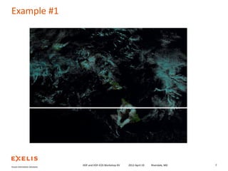
![Example #1
> Construct a VIIRS I-Band (3,2,1) false color composite image.
namespace = 'vis_viirs_'
viirs_file
string
read_dataset
make_rgb
scale_dataset
rgb
bytarr [8241,6164,3]
HDF and HDF-EOS Workshop XV
2012-April-19
Riverdale, MD
6](https://image.slidesharecdn.com/using-idl-with-npp-viirs-data-140214152846-phpapp02/85/Using-IDL-with-Suomi-NPP-VIIRS-Data-6-320.jpg)
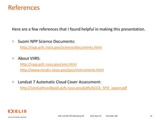
![Example #2
> Construct a cloud mask from VIIRS I-Band imagery.
namespace = 'vis_viirs_'
viirs_file
string
read_dataset
make_cloudmask
scale_dataset
mask
bytarr [8241,6164]
HDF and HDF-EOS Workshop XV
2012-April-19
Riverdale, MD
8](https://image.slidesharecdn.com/using-idl-with-npp-viirs-data-140214152846-phpapp02/85/Using-IDL-with-Suomi-NPP-VIIRS-Data-8-320.jpg)

This document discusses using IDL to work with Suomi NPP VIIRS data. It presents an overview of VIIRS data and examples of constructing false color composite images and cloud masks from VIIRS imagery files. The examples demonstrate reading VIIRS data from HDF5 files, performing image processing, and displaying results. In summary, HDF5 makes it easy to work with Suomi NPP VIIRS data in IDL.