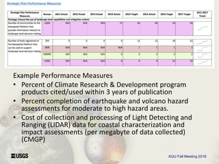
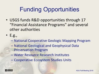
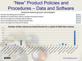
USGS Research Infrastructure
and Assessment Framework
Sky Bristol, Madison
Langseth, Tamar
Norkin
U.S. Department of the Interior
U.S. Geological Survey
USGS Core Science Analytics,
Synthesis and Libraries
AGU Fall Meeting 2016
USGS Research Infrastructure
Assessment Context
• What is the USGS Research Infrastructure?
• Legislated Authorities & Assessment
Mechanisms
– Funded Programs and performance metrics
– Fundamental Science Practices
– RGE, EDGE, and EPAP
– Funding Opportunity programs and assessment
AGU Fall Meeting 2016
Example Performance Measures
• Percent of Climate Research & Development program
products cited/used within 3 years of publication
• Percent completion of earthquake and volcano hazard
assessments for moderate to high hazard areas.
• Cost of collection and processing of Light Detecting and
Ranging (LIDAR) data for coastal characterization and
impact assessments (per megabyte of data collected)
(CMGP)
AGU Fall Meeting 2016
Funding Opportunities
• USGS funds R&D opportunities through 17
“Financial Assistance Programs” and several
other authorities
• E.g.,
– National Cooperative Geologic Mapping Program
– National Geological and Geophysical Data
Preservation Program
– Water Resource Research Institutes
– Cooperative Ecosystem Studies Units
AGU Fall Meeting 2016
Fundamental Science Practices
AGU Fall Meeting 2016
“New” Product Policies and
Procedures – Data and Software
0
20
40
60
80
100
120
140
Number of data releases by hosted domain for a subset of USGS data releases

USGS research infrastructure - AGU2016 - in13 e

  • 1.
    USGS Research Infrastructure andAssessment Framework Sky Bristol, Madison Langseth, Tamar Norkin U.S. Department of the Interior U.S. Geological Survey USGS Core Science Analytics, Synthesis and Libraries
  • 2.
    AGU Fall Meeting2016 USGS Research Infrastructure Assessment Context • What is the USGS Research Infrastructure? • Legislated Authorities & Assessment Mechanisms – Funded Programs and performance metrics – Fundamental Science Practices – RGE, EDGE, and EPAP – Funding Opportunity programs and assessment
  • 3.
  • 4.
  • 5.
    AGU Fall Meeting2016 Example Performance Measures • Percent of Climate Research & Development program products cited/used within 3 years of publication • Percent completion of earthquake and volcano hazard assessments for moderate to high hazard areas. • Cost of collection and processing of Light Detecting and Ranging (LIDAR) data for coastal characterization and impact assessments (per megabyte of data collected) (CMGP)
  • 6.
    AGU Fall Meeting2016 Funding Opportunities • USGS funds R&D opportunities through 17 “Financial Assistance Programs” and several other authorities • E.g., – National Cooperative Geologic Mapping Program – National Geological and Geophysical Data Preservation Program – Water Resource Research Institutes – Cooperative Ecosystem Studies Units
  • 7.
    AGU Fall Meeting2016 Fundamental Science Practices
  • 8.
    AGU Fall Meeting2016 “New” Product Policies and Procedures – Data and Software 0 20 40 60 80 100 120 140 Number of data releases by hosted domain for a subset of USGS data releases

Editor's Notes

  • #3 To provide some context for questions answered in the panel session, I will provide a brief overview of how the USGS operates in context as the independent science bureau within the U.S. Department of the Interior. I say “independent” in the sense that the USGS has no regulatory or law enforcement mission and operates science programs independent of these drivers.