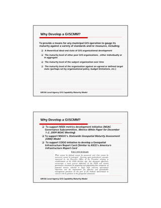
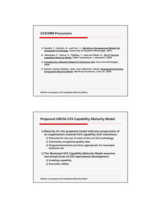
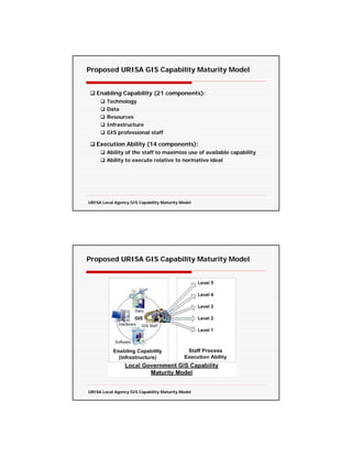
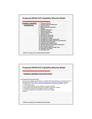
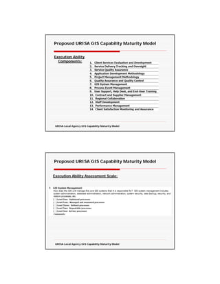
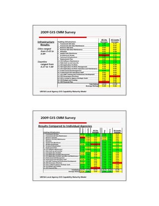
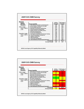
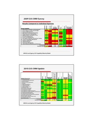
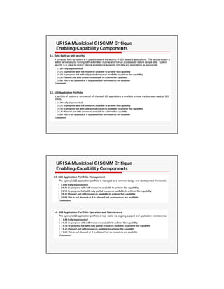
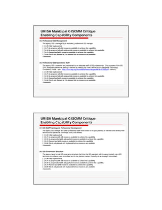
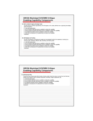
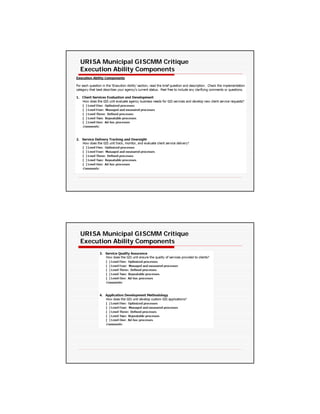
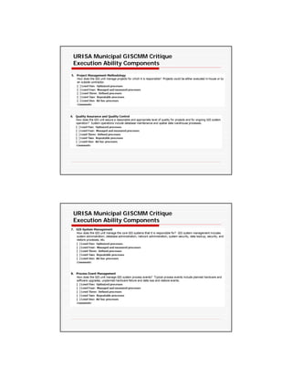
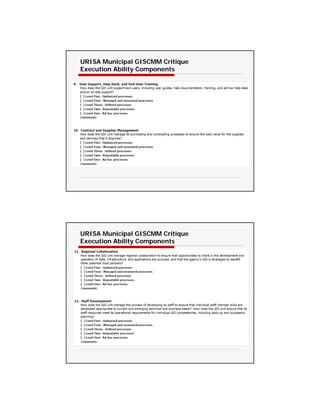
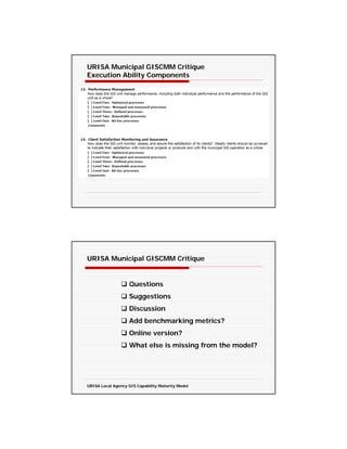
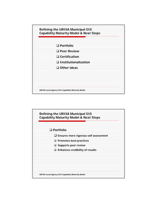
URISA Local Agency
        GIS Capability Maturity Model

                  2011 North Carolina GIS Conference
                          February 17, 2011


                                          Greg Babinski, GISP
                                          URISA President-Elect
                                          Finance & Marketing Manager
                                          King County GIS Center
                                          Seattle, WA


                                  Agenda

         Why Develop a GCMM?
              •     Introduction & framing the problem
              •     What is a capability maturity model?
              •     Why develop a GIS CMM?

         The Proposed URISA GIS Capability Maturity Model
              •     Enabling capability
              •     Execution ability

         GISCMM Description and Group Critique
              •     Walkthrough
              •     Critique

         Feedback, Refining the Model & Next Steps
              •     Portfolio/certification
              •     Peer review
              •     DOLETA GTCM & URISA’s Proposed GMCM
              •     Next steps discussion


URISA Local Agency GIS Capability Maturity Model
Why Develop a GISCMM?

 The Ubiquitous Municipal GIS

     GIS has become a common component of city & county
     government
     All large and most medium sized cities & counties have established
     GIS operations
     Many small sized jurisdictions have a GIS
     31 of 39 Washington Counties have public web mapping capability
     implying GIS operations of some sort
     Dozens of Washington cities are known to have GIS operations


 URISA Local Agency GIS Capability Maturity Model


 Why Develop a GISCMM?

Variations in Municipal GIS Operations

    What causes variation in municipal GIS Operations?
            Each municipality is unique
            City and county business focus often varies
            Population
            Nature and level of economic development


 URISA Local Agency GIS Capability Maturity Model
Why Develop a GISCMM?

Variations in Municipal GIS Operations

   What causes variation in municipal GIS Operations?
           GIS development history and funding
           GIS operational budget and staffing
           GIS strategic plan
           Municipality’s institutional expectations
           GIS developmental vision – or lack of vision?
           Lack of focus?
           Other factors?

        Managers need to balance long-term vision with
         current business needs and operational imperatives

 URISA Local Agency GIS Capability Maturity Model


Why Develop a GISCMM?


 When is GIS Development Complete?

         There are many ways to answer:
                When the GIS capital project was completed?
                When the GIS strategic plan has been completed?
                When a GIS staff is in place?
                When municipal framework and business data has
                been developed?
                Other indicators? applications, products, users, etc.?
                Each of these indicators focuses internally


 URISA Local Agency GIS Capability Maturity Model
What is a Capability Maturity Model?

   A tool to assess an organization’s ability to accomplish a defined
   task or set of tasks
   Originated with the Software Engineering Institute
        Objective evaluation of software contractors
        SEI published Managing the Software Process 1989
        SEI CMM is process focused
   Other applications of the capability maturity model concept:
        System engineering
        Project management
        Risk management
        Information technology service providers


URISA Local Agency GIS Capability Maturity Model


Why Develop a GISCMM?


When is GIS Development Complete?
              There are many ways to answer:
                      With an external focus:
                           Best practices
                           Benchmarking
                      With a theoretical focus:
                           Ideal design
                           Academic state of the art

                      With a capability focus
                      With a maturity level focus


URISA Local Agency GIS Capability Maturity Model
What is a Capability Maturity Model?


           The typical capability maturity model is
                 an assessment of the subject
            organization’s maturity level based on
                   the characteristics of the
             organization’s approach to individual
                       defined processes.


URISA Local Agency GIS Capability Maturity Model


What is a Capability Maturity Model?

    CMM process levels are usually defined as:
    Level 1 – Ad hoc (chaotic) processes - typically in reaction to a need to
      get something done.
    Level 2 – Repeatable processes – typically based on recalling and
      repeating how the process was done the last time.
    Level 3 – Defined process – the process is written down (documented)
      and serves to guide consistent performance within the organization.
    Level 4 – Managed process – the documented process is measured when
      performed and the measurements are compiled for analysis.
      Changing system conditions are managed by adapting the defined
      process to meet the conditions.
    Level 5 – Optimized processes – The defined and managed process is
      improved on an on-going basis by institutionalized process
      improvement planning and implementation. Optimization may be
      tied to quantified performance goals.


URISA Local Agency GIS Capability Maturity Model
Why Develop a GISCMM?

To provide a means for any municipal GIS operation to gauge its
maturity against a variety of standards and/or measures, including:
    A theoretical ideal end state of GIS organizational development

     The maturity level of other peer GIS organizations , either individually or
    in aggregate

    The maturity level of the subject organization over time

     The maturity level of the organization against an agreed or defined target
    state (perhaps set by organizational policy, budget limitations, etc.)


URISA Local Agency GIS Capability Maturity Model


Why Develop a GISCMM?

    To support NSDI metrics development initiative (NGAC
    Governance Subcommittee, Metrics White Paper for December
    1-2, 2009 NGAC Meeting)
    To support NSGIC’s Statewide Geospatial Maturity Assessment
    (GMA) Model
     To support COGO initiative to develop a Geospatial
    Infrastructure Report Card (Similar to ASCE’s America’s
    Infrastructure Report Card


URISA Local Agency GIS Capability Maturity Model
GISCMM Precursors


   Gaudet, C., Annulis, H., and Carr, J., Workforce Development Models for
   Geospatial Technology, University of Southern Mississippi, 2001.

   Niessinka, F., Clerca, V., Tijdinka, T., and van Vlietb, H., The IT Service
   Capability Maturity Model, CIBIT Consultants | Educators, 2005

   Introducing a Maturity Model for Enterprise GIS. Even Keel Strategies,
   2008.

   Sonnen, David, Moeller, John, and LeBranche, David, Geospatial Enterprise
   Integration Maturity Model. Northrup Grumman, June 24, 2009.


URISA Local Agency GIS Capability Maturity Model


Proposed URISA GIS Capability Maturity Model


   Maturity for the proposed model indicates progression of
   an organization towards GIS capability that maximizes:
        Potential for the use of state of the art GIS technology
        Commonly recognized quality data
        Organizational best practices appropriate for municipal
        business use

   The Municipal GIS Capability Maturity Model assumes
   two broad areas of GIS operational development:
        Enabling capability
        Execution ability


URISA Local Agency GIS Capability Maturity Model
Proposed URISA GIS Capability Maturity Model


   Enabling Capability (21 components):
        Technology
        Data
        Resources
        Infrastructure
        GIS professional staff

   Execution Ability (14 components):
        Ability of the staff to maximize use of available capability
        Ability to execute relative to normative ideal


URISA Local Agency GIS Capability Maturity Model


Proposed URISA GIS Capability Maturity Model


URISA Local Agency GIS Capability Maturity Model
Proposed URISA GIS Capability Maturity Model

Enabling Capability
  Components:


 URISA Local Agency GIS Capability Maturity Model


Proposed URISA GIS Capability Maturity Model


 Enabling Capability Assessment Scale:


 URISA Local Agency GIS Capability Maturity Model
Proposed URISA GIS Capability Maturity Model


Execution Ability
  Components:


 URISA Local Agency GIS Capability Maturity Model


Proposed URISA GIS Capability Maturity Model


Execution Ability Assessment Scale:


 URISA Local Agency GIS Capability Maturity Model
2009 GIS CMM Survey

    State of Washington – August 2009
  Based on draft
  Model
  12 Page Survey (4
  pages of
  explanation)
  Sent to 25 Counties
  – 12 responded
  (48%)
  Sent to 38 cities –
  19 responded
  (50%)
  Solicited comments
  and suggestions


  URISA Local Agency GIS Capability Maturity Model


  2009 GIS CMM Survey


Infrastructure
  Results:
Cites ranged
   from 0.43 to
   0.89


Counties
  ranged from
  0.27 to 1.00


  URISA Local Agency GIS Capability Maturity Model
2009 GIS CMM Survey


Infrastructure
  Results:
Cites ranged
   from 0.43 to
   0.89


Counties
  ranged from
  0.27 to 1.00


  URISA Local Agency GIS Capability Maturity Model


  2009 GIS CMM Survey

Results Compared to Individual Agencies


  URISA Local Agency GIS Capability Maturity Model
2009 GIS CMM Survey

Process
  Ability
  Results:
Cites range
   from 1.00 to
   3.93


Counties range
  from 1.00 to
  4.57


   URISA Local Agency GIS Capability Maturity Model


    2009 GIS CMM Survey

Process
  Ability
  Results:
Cites range
   from 1.00 to
   3.93


Counties range
  from 1.00 to
  4.57


   URISA Local Agency GIS Capability Maturity Model
2009 GIS CMM Survey

Results Compared to Individual Agencies


 URISA Local Agency GIS Capability Maturity Model


 2010 GIS CMM Update


 URISA Local Agency GIS Capability Maturity Model
2010 GIS CMM Update


URISA Local Agency GIS Capability Maturity Model


URISA Municipal GISCMM Critique
Enabling Capability Components
URISA Municipal GISCMM Critique
Enabling Capability Components


URISA Municipal GISCMM Critique
Enabling Capability Components
URISA Municipal GISCMM Critique
Enabling Capability Components


URISA Municipal GISCMM Critique
Enabling Capability Components
URISA Municipal GISCMM Critique
Enabling Capability Components


URISA Municipal GISCMM Critique
Enabling Capability Components
URISA Municipal GISCMM Critique
Enabling Capability Components


URISA Municipal GISCMM Critique
Enabling Capability Components
URISA Municipal GISCMM Critique
Enabling Capability Components


URISA Municipal GISCMM Critique
Enabling Capability Components
URISA Municipal GISCMM Critique
Execution Ability Components


URISA Municipal GISCMM Critique
Execution Ability Components
URISA Municipal GISCMM Critique
Execution Ability Components


URISA Municipal GISCMM Critique
Execution Ability Components
URISA Municipal GISCMM Critique
Execution Ability Components


URISA Municipal GISCMM Critique
Execution Ability Components
URISA Municipal GISCMM Critique
Execution Ability Components


URISA Municipal GISCMM Critique


                   Questions
                   Suggestions
                   Discussion
                   Add benchmarking metrics?
                   Online version?
                   What else is missing from the model?


URISA Local Agency GIS Capability Maturity Model
Refining the URISA Municipal GIS
Capability Maturity Model & Next Steps


                     Portfolio
                     Peer Review
                     Certification
                     Institutionalization
                     Other ideas


URISA Local Agency GIS Capability Maturity Model


Refining the URISA Municipal GIS
Capability Maturity Model & Next Steps


              Portfolio
                   Ensures more rigorous self assessment
                   Promotes best practices
                   Supports peer review
                   Enhances credibility of results


URISA Local Agency GIS Capability Maturity Model
Refining the URISA Municipal GIS
Capability Maturity Model & Next Steps


                     Peer Review
                         Normalizes results
                         Enhances credibility of rating


URISA Local Agency GIS Capability Maturity Model


Refining the URISA Municipal GIS
Capability Maturity Model & Next Steps


               Certification & Institutionalization
                    Enhance credibility of results
                    Promote sound professional practices
                    Similar to ISO 9000 and CMMI certification


URISA Local Agency GIS Capability Maturity Model
Refining the URISA Municipal GIS
Capability Maturity Model & Next Steps


    Certification & Institutionalization
        Green Building Council LEED Certification model?


URISA Local Agency GIS Capability Maturity Model


Refining the URISA Municipal GIS
Capability Maturity Model & Next Steps


        Pilot Application of the model across counties in
      Georgia
         Translation of the model into Mandarin Chinese by
      the Taiwan GIS Center & Taiwan GIS Society
        Presentation in Washington, D.C. to NGAC on
      9/22/10 and request report back on future
      development
          2011 FGDC CAP Grant Proposal


URISA Local Agency GIS Capability Maturity Model
Refining the URISA Municipal GIS
Capability Maturity Model & Next Steps


                                                   Link to ROI


URISA Local Agency GIS Capability Maturity Model


Refining the URISA Municipal GIS
Capability Maturity Model & Next Steps


URISA Local Agency GIS Capability Maturity Model
Refining the URISA Municipal GIS
 Capability Maturity Model & Next Steps

   DOLETA GTCM
  Missing Tier 9 Management
Competency Model:
    • Staffing
    • Informing
    • Delegating
    • Networking
    • Monitoring Work
    • Entrepreneurship
    • Supporting Others
    • Motivating & Inspiring
    • Developing & Mentoring
    • Strategic Planning/Action
    • Preparing & Evaluating Budgets
    • Clarifying Roles & Objectives
    • Managing Conflict & Team Building
    • Developing an Organizational Vision
    • Monitoring & Controlling Resources


 URISA Local Agency GIS Capability Maturity Model


 Refining the URISA Municipal GIS
 Capability Maturity Model & Next Steps


   GISCMM – GMCM Daylong Work Session at 2011
 Washington GIS Conference
   Possible URISA-USDOLETA Daylong GMCM Work Session at
 2011 GIS-Pro in Indianapolis


 URISA Local Agency GIS Capability Maturity Model
Refining the URISA Municipal GIS
Capability Maturity Model & Next Steps


          Other ideas?
          Open Discussion


URISA Local Agency GIS Capability Maturity Model


Acknowledgements

           Reviewers:
           Danielle Ayan, GISP, State of Georgia
           Lisa Castle, King County GIS Center
           Richard Gelb, King County DNRP
           George Horning, King County GIS Center
           Mike Leathers, King County GIS Center

           Washington State City & County GIS Managers
           2010 GIS-Pro Workshop Participants

           Hilary Perkins
           Twyla McDermott
           David DiBiase


URISA Local Agency GIS Capability Maturity Model
References
Capability Maturity Model, Wikepedia Article: http://en.wikipedia.org/wiki/Capability_Maturity_Model
Accessed 8/3/2009).
Selena Rezvani, M.S.W., An Introduction to Organizational Maturity Assessment: Measuring
Organizational Capabilities, International Public Management Association Assessment Council, ND.
Jerry Simonoff, Director, IT Investment & Enterprise Solutions, Improving IT investment Management
in the Commonwealth, Virginia Information Technology Agency, 2008.
Curtis, B., Hefley, W. E., and Miller, S. A.; People Capability Maturity Model (P-CMM), Software
Engineering Institute, 2001.
Niessinka, F., Clerca, V., Tijdinka, T., and van Vlietb, H., The IT Service Capability Maturity Model,
CIBIT Consultants | Educators, 2005
Ford-Bey, M., PA Consulting Group, Proving the Business Benefits of GeoWeb Initiatives: An ROI-
Driven Approach, GeoWeb Conference, 2008.
Niessink, F. and van Vliet, H., Towards Mature IT Services, Faculty of Mathematics and Computer
Science, Vrije Universiteit Amsterdam, ND.
Gaudet, C., Annulis, H., and Carr, J., Workforce Development Models for Geospatial Technology,
University of Southern Mississippi, 2001.
Sonnen, David, Moeller, John, and LeBranche, David, Geospatial Enterprise Integration Maturity Model.
Northrup Grumman, June 24, 2009.
NGAC Governance Subcommittee: Metrics White Paper for December 1-2, 2009 NGAC Meeting,
accessed at: http://www.fgdc.gov/ngac/meetings/december-2009/governance-subcommittee-nsdi-
metrics-paper.pdf


URISA Local Agency GIS Capability Maturity Model


       Contact Information
             Greg Babinski, GISP, King County GIS Center, Seattle, WA
             Greg.babinski@kingcounty.gov
             206-263-3753

       Winter 2011 ArcNews Article:
       http://www.esri.com/news/arcnews/winter1011articles/urisa-proposes.html


URISA Local Agency GIS Capability Maturity Model

URISA GIS Capability Maturity Model

  • 1.
    URISA Local Agency GIS Capability Maturity Model 2011 North Carolina GIS Conference February 17, 2011 Greg Babinski, GISP URISA President-Elect Finance & Marketing Manager King County GIS Center Seattle, WA Agenda Why Develop a GCMM? • Introduction & framing the problem • What is a capability maturity model? • Why develop a GIS CMM? The Proposed URISA GIS Capability Maturity Model • Enabling capability • Execution ability GISCMM Description and Group Critique • Walkthrough • Critique Feedback, Refining the Model & Next Steps • Portfolio/certification • Peer review • DOLETA GTCM & URISA’s Proposed GMCM • Next steps discussion URISA Local Agency GIS Capability Maturity Model
  • 2.
    Why Develop aGISCMM? The Ubiquitous Municipal GIS GIS has become a common component of city & county government All large and most medium sized cities & counties have established GIS operations Many small sized jurisdictions have a GIS 31 of 39 Washington Counties have public web mapping capability implying GIS operations of some sort Dozens of Washington cities are known to have GIS operations URISA Local Agency GIS Capability Maturity Model Why Develop a GISCMM? Variations in Municipal GIS Operations What causes variation in municipal GIS Operations? Each municipality is unique City and county business focus often varies Population Nature and level of economic development URISA Local Agency GIS Capability Maturity Model
  • 3.
    Why Develop aGISCMM? Variations in Municipal GIS Operations What causes variation in municipal GIS Operations? GIS development history and funding GIS operational budget and staffing GIS strategic plan Municipality’s institutional expectations GIS developmental vision – or lack of vision? Lack of focus? Other factors? Managers need to balance long-term vision with current business needs and operational imperatives URISA Local Agency GIS Capability Maturity Model Why Develop a GISCMM? When is GIS Development Complete? There are many ways to answer: When the GIS capital project was completed? When the GIS strategic plan has been completed? When a GIS staff is in place? When municipal framework and business data has been developed? Other indicators? applications, products, users, etc.? Each of these indicators focuses internally URISA Local Agency GIS Capability Maturity Model
  • 4.
    What is aCapability Maturity Model? A tool to assess an organization’s ability to accomplish a defined task or set of tasks Originated with the Software Engineering Institute Objective evaluation of software contractors SEI published Managing the Software Process 1989 SEI CMM is process focused Other applications of the capability maturity model concept: System engineering Project management Risk management Information technology service providers URISA Local Agency GIS Capability Maturity Model Why Develop a GISCMM? When is GIS Development Complete? There are many ways to answer: With an external focus: Best practices Benchmarking With a theoretical focus: Ideal design Academic state of the art With a capability focus With a maturity level focus URISA Local Agency GIS Capability Maturity Model
  • 5.
    What is aCapability Maturity Model? The typical capability maturity model is an assessment of the subject organization’s maturity level based on the characteristics of the organization’s approach to individual defined processes. URISA Local Agency GIS Capability Maturity Model What is a Capability Maturity Model? CMM process levels are usually defined as: Level 1 – Ad hoc (chaotic) processes - typically in reaction to a need to get something done. Level 2 – Repeatable processes – typically based on recalling and repeating how the process was done the last time. Level 3 – Defined process – the process is written down (documented) and serves to guide consistent performance within the organization. Level 4 – Managed process – the documented process is measured when performed and the measurements are compiled for analysis. Changing system conditions are managed by adapting the defined process to meet the conditions. Level 5 – Optimized processes – The defined and managed process is improved on an on-going basis by institutionalized process improvement planning and implementation. Optimization may be tied to quantified performance goals. URISA Local Agency GIS Capability Maturity Model
  • 6.
    Why Develop aGISCMM? To provide a means for any municipal GIS operation to gauge its maturity against a variety of standards and/or measures, including: A theoretical ideal end state of GIS organizational development The maturity level of other peer GIS organizations , either individually or in aggregate The maturity level of the subject organization over time The maturity level of the organization against an agreed or defined target state (perhaps set by organizational policy, budget limitations, etc.) URISA Local Agency GIS Capability Maturity Model Why Develop a GISCMM? To support NSDI metrics development initiative (NGAC Governance Subcommittee, Metrics White Paper for December 1-2, 2009 NGAC Meeting) To support NSGIC’s Statewide Geospatial Maturity Assessment (GMA) Model To support COGO initiative to develop a Geospatial Infrastructure Report Card (Similar to ASCE’s America’s Infrastructure Report Card URISA Local Agency GIS Capability Maturity Model
  • 7.
    GISCMM Precursors Gaudet, C., Annulis, H., and Carr, J., Workforce Development Models for Geospatial Technology, University of Southern Mississippi, 2001. Niessinka, F., Clerca, V., Tijdinka, T., and van Vlietb, H., The IT Service Capability Maturity Model, CIBIT Consultants | Educators, 2005 Introducing a Maturity Model for Enterprise GIS. Even Keel Strategies, 2008. Sonnen, David, Moeller, John, and LeBranche, David, Geospatial Enterprise Integration Maturity Model. Northrup Grumman, June 24, 2009. URISA Local Agency GIS Capability Maturity Model Proposed URISA GIS Capability Maturity Model Maturity for the proposed model indicates progression of an organization towards GIS capability that maximizes: Potential for the use of state of the art GIS technology Commonly recognized quality data Organizational best practices appropriate for municipal business use The Municipal GIS Capability Maturity Model assumes two broad areas of GIS operational development: Enabling capability Execution ability URISA Local Agency GIS Capability Maturity Model
  • 8.
    Proposed URISA GISCapability Maturity Model Enabling Capability (21 components): Technology Data Resources Infrastructure GIS professional staff Execution Ability (14 components): Ability of the staff to maximize use of available capability Ability to execute relative to normative ideal URISA Local Agency GIS Capability Maturity Model Proposed URISA GIS Capability Maturity Model URISA Local Agency GIS Capability Maturity Model
  • 9.
    Proposed URISA GISCapability Maturity Model Enabling Capability Components: URISA Local Agency GIS Capability Maturity Model Proposed URISA GIS Capability Maturity Model Enabling Capability Assessment Scale: URISA Local Agency GIS Capability Maturity Model
  • 10.
    Proposed URISA GISCapability Maturity Model Execution Ability Components: URISA Local Agency GIS Capability Maturity Model Proposed URISA GIS Capability Maturity Model Execution Ability Assessment Scale: URISA Local Agency GIS Capability Maturity Model
  • 11.
    2009 GIS CMMSurvey State of Washington – August 2009 Based on draft Model 12 Page Survey (4 pages of explanation) Sent to 25 Counties – 12 responded (48%) Sent to 38 cities – 19 responded (50%) Solicited comments and suggestions URISA Local Agency GIS Capability Maturity Model 2009 GIS CMM Survey Infrastructure Results: Cites ranged from 0.43 to 0.89 Counties ranged from 0.27 to 1.00 URISA Local Agency GIS Capability Maturity Model
  • 12.
    2009 GIS CMMSurvey Infrastructure Results: Cites ranged from 0.43 to 0.89 Counties ranged from 0.27 to 1.00 URISA Local Agency GIS Capability Maturity Model 2009 GIS CMM Survey Results Compared to Individual Agencies URISA Local Agency GIS Capability Maturity Model
  • 13.
    2009 GIS CMMSurvey Process Ability Results: Cites range from 1.00 to 3.93 Counties range from 1.00 to 4.57 URISA Local Agency GIS Capability Maturity Model 2009 GIS CMM Survey Process Ability Results: Cites range from 1.00 to 3.93 Counties range from 1.00 to 4.57 URISA Local Agency GIS Capability Maturity Model
  • 14.
    2009 GIS CMMSurvey Results Compared to Individual Agencies URISA Local Agency GIS Capability Maturity Model 2010 GIS CMM Update URISA Local Agency GIS Capability Maturity Model
  • 15.
    2010 GIS CMMUpdate URISA Local Agency GIS Capability Maturity Model URISA Municipal GISCMM Critique Enabling Capability Components
  • 16.
    URISA Municipal GISCMMCritique Enabling Capability Components URISA Municipal GISCMM Critique Enabling Capability Components
  • 17.
    URISA Municipal GISCMMCritique Enabling Capability Components URISA Municipal GISCMM Critique Enabling Capability Components
  • 18.
    URISA Municipal GISCMMCritique Enabling Capability Components URISA Municipal GISCMM Critique Enabling Capability Components
  • 19.
    URISA Municipal GISCMMCritique Enabling Capability Components URISA Municipal GISCMM Critique Enabling Capability Components
  • 20.
    URISA Municipal GISCMMCritique Enabling Capability Components URISA Municipal GISCMM Critique Enabling Capability Components
  • 21.
    URISA Municipal GISCMMCritique Execution Ability Components URISA Municipal GISCMM Critique Execution Ability Components
  • 22.
    URISA Municipal GISCMMCritique Execution Ability Components URISA Municipal GISCMM Critique Execution Ability Components
  • 23.
    URISA Municipal GISCMMCritique Execution Ability Components URISA Municipal GISCMM Critique Execution Ability Components
  • 24.
    URISA Municipal GISCMMCritique Execution Ability Components URISA Municipal GISCMM Critique Questions Suggestions Discussion Add benchmarking metrics? Online version? What else is missing from the model? URISA Local Agency GIS Capability Maturity Model
  • 25.
    Refining the URISAMunicipal GIS Capability Maturity Model & Next Steps Portfolio Peer Review Certification Institutionalization Other ideas URISA Local Agency GIS Capability Maturity Model Refining the URISA Municipal GIS Capability Maturity Model & Next Steps Portfolio Ensures more rigorous self assessment Promotes best practices Supports peer review Enhances credibility of results URISA Local Agency GIS Capability Maturity Model
  • 26.
    Refining the URISAMunicipal GIS Capability Maturity Model & Next Steps Peer Review Normalizes results Enhances credibility of rating URISA Local Agency GIS Capability Maturity Model Refining the URISA Municipal GIS Capability Maturity Model & Next Steps Certification & Institutionalization Enhance credibility of results Promote sound professional practices Similar to ISO 9000 and CMMI certification URISA Local Agency GIS Capability Maturity Model
  • 27.
    Refining the URISAMunicipal GIS Capability Maturity Model & Next Steps Certification & Institutionalization Green Building Council LEED Certification model? URISA Local Agency GIS Capability Maturity Model Refining the URISA Municipal GIS Capability Maturity Model & Next Steps Pilot Application of the model across counties in Georgia Translation of the model into Mandarin Chinese by the Taiwan GIS Center & Taiwan GIS Society Presentation in Washington, D.C. to NGAC on 9/22/10 and request report back on future development 2011 FGDC CAP Grant Proposal URISA Local Agency GIS Capability Maturity Model
  • 28.
    Refining the URISAMunicipal GIS Capability Maturity Model & Next Steps Link to ROI URISA Local Agency GIS Capability Maturity Model Refining the URISA Municipal GIS Capability Maturity Model & Next Steps URISA Local Agency GIS Capability Maturity Model
  • 29.
    Refining the URISAMunicipal GIS Capability Maturity Model & Next Steps DOLETA GTCM Missing Tier 9 Management Competency Model: • Staffing • Informing • Delegating • Networking • Monitoring Work • Entrepreneurship • Supporting Others • Motivating & Inspiring • Developing & Mentoring • Strategic Planning/Action • Preparing & Evaluating Budgets • Clarifying Roles & Objectives • Managing Conflict & Team Building • Developing an Organizational Vision • Monitoring & Controlling Resources URISA Local Agency GIS Capability Maturity Model Refining the URISA Municipal GIS Capability Maturity Model & Next Steps GISCMM – GMCM Daylong Work Session at 2011 Washington GIS Conference Possible URISA-USDOLETA Daylong GMCM Work Session at 2011 GIS-Pro in Indianapolis URISA Local Agency GIS Capability Maturity Model
  • 30.
    Refining the URISAMunicipal GIS Capability Maturity Model & Next Steps Other ideas? Open Discussion URISA Local Agency GIS Capability Maturity Model Acknowledgements Reviewers: Danielle Ayan, GISP, State of Georgia Lisa Castle, King County GIS Center Richard Gelb, King County DNRP George Horning, King County GIS Center Mike Leathers, King County GIS Center Washington State City & County GIS Managers 2010 GIS-Pro Workshop Participants Hilary Perkins Twyla McDermott David DiBiase URISA Local Agency GIS Capability Maturity Model
  • 31.
    References Capability Maturity Model,Wikepedia Article: http://en.wikipedia.org/wiki/Capability_Maturity_Model Accessed 8/3/2009). Selena Rezvani, M.S.W., An Introduction to Organizational Maturity Assessment: Measuring Organizational Capabilities, International Public Management Association Assessment Council, ND. Jerry Simonoff, Director, IT Investment & Enterprise Solutions, Improving IT investment Management in the Commonwealth, Virginia Information Technology Agency, 2008. Curtis, B., Hefley, W. E., and Miller, S. A.; People Capability Maturity Model (P-CMM), Software Engineering Institute, 2001. Niessinka, F., Clerca, V., Tijdinka, T., and van Vlietb, H., The IT Service Capability Maturity Model, CIBIT Consultants | Educators, 2005 Ford-Bey, M., PA Consulting Group, Proving the Business Benefits of GeoWeb Initiatives: An ROI- Driven Approach, GeoWeb Conference, 2008. Niessink, F. and van Vliet, H., Towards Mature IT Services, Faculty of Mathematics and Computer Science, Vrije Universiteit Amsterdam, ND. Gaudet, C., Annulis, H., and Carr, J., Workforce Development Models for Geospatial Technology, University of Southern Mississippi, 2001. Sonnen, David, Moeller, John, and LeBranche, David, Geospatial Enterprise Integration Maturity Model. Northrup Grumman, June 24, 2009. NGAC Governance Subcommittee: Metrics White Paper for December 1-2, 2009 NGAC Meeting, accessed at: http://www.fgdc.gov/ngac/meetings/december-2009/governance-subcommittee-nsdi- metrics-paper.pdf URISA Local Agency GIS Capability Maturity Model Contact Information Greg Babinski, GISP, King County GIS Center, Seattle, WA Greg.babinski@kingcounty.gov 206-263-3753 Winter 2011 ArcNews Article: http://www.esri.com/news/arcnews/winter1011articles/urisa-proposes.html URISA Local Agency GIS Capability Maturity Model