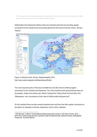
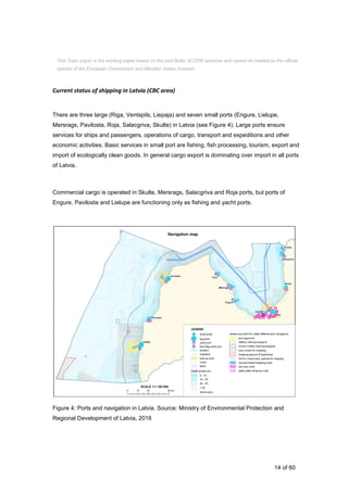
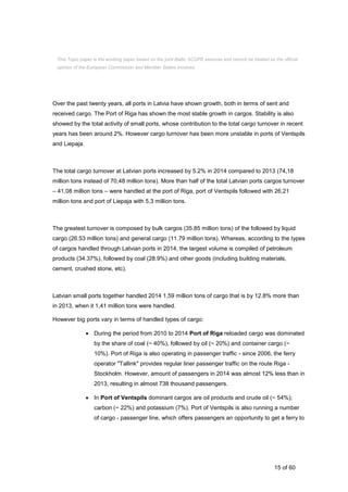
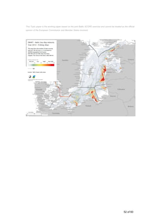
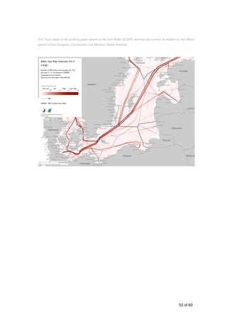
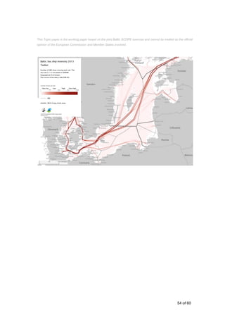
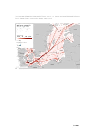
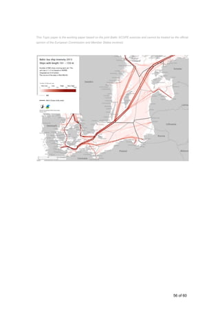
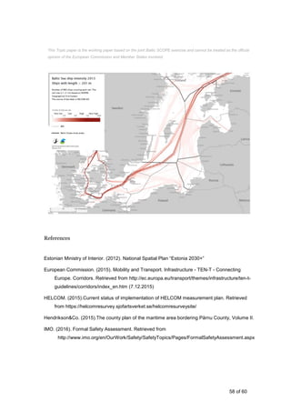
The document analyzes shipping in the Central Baltic region, including Estonia, Latvia, and Sweden. It finds that shipping is most intensive in Swedish waters passing Gotland and heading to the Gulf of Finland, and around the port of Riga. In Estonia, the ports of Pärnu and Saaremaa Harbour are highlighted as important for regional and international connections. Requirements for shipping include space for lanes and routes of various vessel types and sizes. Future developments may include changes to vessel sizes and routes. Transboundary alignment of shipping routes is recommended.
* This Topic paper is the working paper based on the joint Baltic SCOPE exercise and cannot be treated as the official opinion of the European Commission and Member States involved.
Read more on: www.balticscope.eu
* This Topic paper is the working paper based on the joint Baltic SCOPE exercise and cannot be treated as the official opinion of the European Commission and Member States involved.
Read more on: www.balticscope.eu
* This Topic paper is the working paper based on the joint Baltic SCOPE exercise and cannot be treated as the official opinion of the European Commission and Member States involved.
Read more on: www.balticscope.eu
The document provides an analysis of shipping in the Central Baltic region, including Estonia, Latvia, and Sweden. It finds that shipping is most intensive in Swedish waters passing Gotland and heading to the Gulf of Finland, and around the port of Riga. In Estonia, the major ports are Pärnu Port and Saaremaa Harbour, which provide important domestic and international ferry connections. Pärnu Port experiences ice in winter and requires icebreaking. Saaremaa Harbour can accommodate larger cruise ships. Latvia has "reserved zones" designated for shipping. Future developments may include changes to vessel size and rerouting of some shipping lanes. Harmonizing shipping routes across borders and involving relevant international organizations will be important for marine
* This Topic paper is the working paper based on the joint Baltic SCOPE exercise and cannot be treated as the official opinion of the European Commission and Member States involved.
Read more on: www.balticscope.eu
* This Topic paper is the working paper based on the joint Baltic SCOPE exercise and cannot be treated as the official opinion of the European Commission and the Member States involved.
Read more on: www.balticscope.eu
* This Topic paper is the working paper based on the joint Baltic SCOPE exercise and cannot be treated as the official opinion of the European Commission and Member States involved.
Read more on: www.balticscope.eu
* This Topic paper is the working paper based on the joint Baltic SCOPE exercise and cannot be treated as the official opinion of the European Commission and Member States involved.
Read more on: www.balticscope.eu
* This Topic paper is the working paper based on the joint Baltic SCOPE exercise and cannot be treated as the official opinion of the European Commission and Member States involved.
Read more on: www.balticscope.eu
* This Topic paper is the working paper based on the joint Baltic SCOPE exercise and cannot be treated as the official opinion of the European Commission and Member States involved.
Read more on: www.balticscope.eu
* This Topic paper is the working paper based on the joint Baltic SCOPE exercise and cannot be treated as the official opinion of the European Commission and Member States involved.
Read more on: www.balticscope.eu
The document provides an analysis of shipping in the Central Baltic region, including Estonia, Latvia, and Sweden. It finds that shipping is most intensive in Swedish waters passing Gotland and heading to the Gulf of Finland, and around the port of Riga. In Estonia, the major ports are Pärnu Port and Saaremaa Harbour, which provide important domestic and international ferry connections. Pärnu Port experiences ice in winter and requires icebreaking. Saaremaa Harbour can accommodate larger cruise ships. Latvia has "reserved zones" designated for shipping. Future developments may include changes to vessel size and rerouting of some shipping lanes. Harmonizing shipping routes across borders and involving relevant international organizations will be important for marine
* This Topic paper is the working paper based on the joint Baltic SCOPE exercise and cannot be treated as the official opinion of the European Commission and Member States involved.
Read more on: www.balticscope.eu
* This Topic paper is the working paper based on the joint Baltic SCOPE exercise and cannot be treated as the official opinion of the European Commission and the Member States involved.
Read more on: www.balticscope.eu
* This Topic paper is the working paper based on the joint Baltic SCOPE exercise and cannot be treated as the official opinion of the European Commission and Member States involved.
Read more on: www.balticscope.eu
* This Topic paper is the working paper based on the joint Baltic SCOPE exercise and cannot be treated as the official opinion of the European Commission and Member States involved.
Read more on: www.balticscope.eu
Maritime Spatial Plan in Latvia
* The information presented is the working exercise of the cross-border maritime spatial planning discussions and can not be treated as the official opinion of the European Commission and the Member States involved in the consortium of the Baltic SCOPE project.
Baltic SCOPE kick-off - Tackling MSP integration challenges in the BSR by Michael Gilek, BaltSpace Project Coordinator, Södertörn University
29 September 2015 Riga, Latvia
* The information presented is the working exercise of the cross-border maritime spatial planning discussions and can not be treated as the official opinion of the European Commission and the Member States involved in the consortium of the Baltic SCOPE project.
Baltic SCOPE kick-off - Cross-border planning in Adriatic Ionian MSP, ADRIPLAN project by Francesco Musco, University IUAV of Venice
29 September Riga, Latvia
* The information presented is the working exercise of the cross-border maritime spatial planning discussions and can not be treated as the official opinion of the European Commission and the Member States involved in the consortium of the Baltic SCOPE project.
Baltic SCOPE Topic Paper - Environment by Magdalena Wesolowska, Maritime Office in Szczecin, Poland, at Baltic SCOPE Southwest Baltic case stakeholder meeting on 27 January 2016 in Malmo, SWEDEN
www.balticscope.eu
* The information presented is the working exercise of the cross-border maritime spatial planning discussions and can not be treated as the official opinion of the European Commission and the Member States involved in the consortium of the Baltic SCOPE project.
Baltic SCOPE kick-off - Cross-Border cooperation in the North sea by Leo de Vrees, Netherlands Ministry of Infrastructure and the Environment
* The information presented is the working exercise of the cross-border maritime spatial planning discussions and can not be treated as the official opinion of the European Commission and the Member States involved in the consortium of the Baltic SCOPE project.
Implementation of Maritime Spatial Planning in Denmark – state of the art by Ellen Hjort Petersen, Danish Nature Agency at Baltic SCOPE Southwest Baltic case stakeholder meeting on 27 January 2016 in Malmo, SWEDEN
www.balticscope.eu
* The information presented is the working exercise of the cross-border maritime spatial planning discussions and can not be treated as the official opinion of the European Commission and the Member States involved in the consortium of the Baltic SCOPE project.
Findings and recommendations from Central Baltic case by Ingūna Urtāne, Director of Spatial Planning Department of the Ministry of Environmental Protection and Regional Development at the workshop 'Recommendations on transboundary planning from Baltic SCOPE' at the 2nd Baltic Maritime Spatial Planning Forum in Riga, Latvia on 23 November 2016 (the final conference of the Baltic SCOPE collaboration).
Video and other presentations - www.balticscope.eu
www.vasab.org
Introduction of the Central Baltic case
* The information presented is the working exercise of the cross-border maritime spatial planning discussions and can not be treated as the official opinion of the European Commission and the Member States involved in the consortium of the Baltic SCOPE project.
The presentation of the frame of the Southwest Baltic Case
* The information presented is the working exercise of the cross-border maritime spatial planning discussions and can not be treated as the official opinion of the European Commission and the Member States involved in the consortium of the Baltic SCOPE project.
Baltic SCOPE workshop discussion on ENVIRONMENT at Baltic SCOPE Central Baltic case (involving Latvia, Estonia and Sweden) stakeholder conference on 31 May - 1 June 2016 in Jurmala, LATVIA
Read more on: www.balticscope.eu
* The information presented is the working exercise on the cross-border maritime spatial planning discussions and can not be treated as the official opinion of the European Commission and the Member States involved in the consortium of the Baltic SCOPE project.
Progress of the Baltic SCOPE Ecosystem Approach topic at project's partner meeting on 21-22 June 2016 in Szczecin, POLAND
Read more on: www.balticscope.eu
* The information presented is the working exercise on the cross-border maritime spatial planning discussions and can not be treated as the official opinion of the European Commission and the Member States involved in the consortium of the Baltic SCOPE project.
Maritime Spatial Planning in Poland by Marta Konik, Maritime Office in Szczecin at Baltic SCOPE Southwest Baltic case stakeholder meeting on 27 January 2016 in Malmo, SWEDEN
www.balticscope.eu
* The information presented is the working exercise of the cross-border maritime spatial planning discussions and can not be treated as the official opinion of the European Commission and the Member States involved in the consortium of the Baltic SCOPE project.
Baltic SCOPE workshop discussion on SHIPPING at Baltic SCOPE Central Baltic case (involving Latvia, Estonia and Sweden) stakeholder conference on 31 May - 1 June 2016 in Jurmala, LATVIA
Read more on: www.balticscope.eu
* The information presented is the working exercise on the cross-border maritime spatial planning discussions and can not be treated as the official opinion of the European Commission and the Member States involved in the consortium of the Baltic SCOPE project.
Progress of the Baltic SCOPE cases June 2016 - Southwest Baltic (involving Sweden, Poland, Germany, Denmark) at project's partner meeting on 21-22 June 2016 in Szczecin, POLAND
Read more on: www.balticscope.eu
* The information presented is the working exercise on the cross-border maritime spatial planning discussions and can not be treated as the official opinion of the European Commission and the Member States involved in the consortium of the Baltic SCOPE project.
Report on the Baltic SCOPE Southwest Baltic case stakeholder meeting on 27 January 2016 in Malmo, SWEDEN
www.balticscope.eu
* The information presented is the working exercise of the cross-border maritime spatial planning discussions and can not be treated as the official opinion of the European Commission and the Member States involved in the consortium of the Baltic SCOPE project.
Baltic SCOPE workshop discussion on SHIPPING at Baltic SCOPE Central Baltic case (involving Latvia, Estonia and Sweden) stakeholder conference on 31 May - 1 June 2016 in Jurmala, LATVIA
Read more on: www.balticscope.eu
* The information presented is the working exercise on the cross-border maritime spatial planning discussions and can not be treated as the official opinion of the European Commission and the Member States involved in the consortium of the Baltic SCOPE project.
This document summarizes a kick-off meeting for the Baltic SCOPE project. The meeting was held on March 18-19, 2015 in Gothenburg, Sweden. Baltic SCOPE is a two-year project aiming to foster coherence and cross-border solutions in Baltic maritime spatial plans. Key topics discussed at the meeting included the project objectives, partnership, case study areas, timelines, and roles and responsibilities of the participating organizations.
Baltic SCOPE workshop discussion on SHIPPING at Baltic SCOPE Central Baltic case (involving Latvia, Estonia and Sweden) stakeholder conference on 31 May - 1 June 2016 in Jurmala, LATVIA
Read more on: www.balticscope.eu
* The information presented is the working exercise on the cross-border maritime spatial planning discussions and can not be treated as the official opinion of the European Commission and the Member States involved in the consortium of the Baltic SCOPE project.
The report "Development of a Maritime Spatial Plan: The Latvian Recipe" is a draft for the maritime spatial plan for the Republic of Latvia. It describes the methodology used in it to include the internal and territorial waters and Exclusive Economic Zone in the Maritime Spatial Planning.
During the process, certain priorities took shape: four sector-based and two cross-cutting. The sectors were maritime transport, fishery, tourism and production of renewable energy, while the cross-cutting included environment and state security.
www.balticscope.eu
Shipping is vital in the Western Baltic region with over 1 ship passing every 10 minutes. Navigation is complicated and new sectors like energy development may challenge safety if not properly planned. The document discusses potential conflicts between shipping routes and energy installations like wind farms, noting that single obstacles can be avoided but multiple obstacles are more difficult for ships to navigate around. Safety zones will need to be established between shipping routes and energy projects to prevent collisions and disturbances to radar. Recommendations so far include respecting international shipping regulations and not rerouting major routes or traffic separation schemes.
This document provides a summary of a manual on best practices for clean shipping and port operations in the Baltic Sea region. The manual was produced as part of the BSR InnoShip project, which aimed to reduce ship and port emissions through knowledge sharing and innovation. The manual contains information on the current status of shipping traffic and emissions in the Baltic Sea, relevant regulations and their enforcement, best practices for ships and ports to reduce emissions, and general recommendations. It is intended to provide guidance to authorities, shipowners, ports and others on preparing for tighter emission regulations.
International Cooperation in the Arctic. 2013 ReportRussian Council
The report continues work held in line with the “Roadmap for International Cooperation in the Arctic” project organized by the Russian International Affairs Council (RIAC). The report covers the results of international cooperation in the Arctic region in 2013. The authors focused on four basic areas of cooperation: strengthening of the Arctic Council
fisheries regulation, vessel traffic issues, and harmonization of national environmental legislation.
Spatial planners work in different contexts and have different objectives depending on which country is in question. That is something that became very clear during our collaboration. Therefore an evaluation framework has to be flexible, so that it can be adapted to different contexts.
The evaluation framework we developed presents a set of criteria and indicators that can be used in future evaluations. It gives methodological guidance for evaluating Maritime Spatial Planning processes, with an emphasis on transboundary aspects. The framework could also be used for designing effective planning processes.
Read more about the project www.balticscope.eu
This document provides an assessment of the ecological coherence of the marine protected area (MPA) network in the Baltic Sea. It finds that while the total protected area has increased from 3.9% in 2004 to 11.8% in 2016, meeting international targets, the network does not fully meet the criteria of representativity, replication, adequacy, and connectivity due to certain habitats and species still being underrepresented. It recommends further designating new sites to improve coverage of underrepresented features and increasing management measures and cross-border cooperation to enhance the network. The assessment concludes there is still progress needed to achieve an ecologically coherent and effectively managed MPA network in the Baltic Sea as committed to in HELCOM Recommendation 35/
This document provides an introduction to the guide "Moving Sustainably: Guide to Sustainable Urban Transport Plans". It outlines the challenges cities face related to urban transport and the need for Sustainable Urban Transport Plans (SUTPs) to address these challenges. It describes the two main components of a SUTP - the planning process and the plan itself. It also introduces the structure and contents of the guide, which is based on experiences from 12 cities in the BUSTRIP project.
Summary:
ICE ARC Project
ASSESSING CLIMATE CHANGE IMPACTS ON MARINE ECOSYSTEMS AND HUMAN ACTIVITIES
IN THE ARCTIC OCEAN: THE EUROPEAN ACCESS PROGRAMME (2011-2015)
THE YEAR OF POLAR PREDICTION (YOPP): CHALLENGES AND OPPORTUNITIES
IN ICE-OCEAN FORECASTING
IAOOS (ICE - ATMOSPHERE - ARCTIC OCEAN OBSERVING SYSTEM, 2011-2019)
SEA ICE ANALYSIS AND FORECASTING WITH GLOSEA5
RECENT PROGRESS IN SEA ICE DATA ASSIMILATION AT ENVIRONMENT CANADA
RECENT DEVELOPMENTS IMPACTING THE SEA ICE IN THE MERCATOR OCÉAN GLOBAL ¼° CONFIGURATION
PARAMETERIZATION OF DRAG COEFFICIENTS OVER POLAR SEA ICE FOR CLIMATE MODELS
A MAXWELL-ELASTO-BRITTLE RHEOLOGY FOR SEA ICE MODELING
The document introduces the concept of shared mobility as a potential solution to address the negative impacts of car-dominated urban transport systems. It discusses how previous approaches have focused on promoting public transport, reducing travel needs, and improving vehicle technology. A new simulation is presented that models replacing all car and bus trips in a city with on-demand shared vehicles, including shared taxis and mini-buses. The simulation finds this approach could significantly reduce traffic, emissions, and parking needs while improving access and social inclusion. It examines the impacts on vehicle requirements, travel patterns, and the citizen experience of using shared mobility services.
RESULTS OF A WORKING GROUP OF THE EUROPEAN COMMISSION CONSISTING OF REPRESEN...Cláudio Carneiro
This document discusses the challenges of managing estuaries and coastal zones, which are ecologically important habitats but also locations for expanding port activities. It established a working group to provide guidance on applying nature directives like the Habitats and Birds Directives to port development projects. The group aimed to enhance information sharing on managing ports and Natura 2000 network sites, and provide general guidance on applying nature laws in estuaries and coastal areas used for ports. The document outlines the ecological value and economic importance of these areas, as well as the increasing demands for shipping capacity. It notes the potential conflicts between protecting habitats under EU environmental laws while also seeking to expand port infrastructure under transport and economic policies.
PLATINA 2_Manual on Waterway Maintenance_finalDaniel S. Hayes
This document provides a summary of a good practice manual on inland waterway maintenance. The manual focuses on maintenance of the fairway, which refers to the part of an inland waterway that is maintained to a targeted depth and width to enable continuous navigation. The objectives of the manual are to illustrate an improved fairway maintenance cycle that considers processes beyond just implementing measures, and to describe proactive fairway maintenance strategies. It analyzes good practice examples from several European waterway corridors to derive recommendations for waterway administrations. The elaboration was supported by a European expert group on waterway maintenance.
Editorial – April 2011 – Special Issue jointly coordinated by Mercator Ocean and Coriolis
focusing on Ocean Observations
Greetings all,
Once a year in April, and for the second time after the April 2010 issue, the Mercator Ocean Forecasting Center in Toulouse and the Coriolis
Infrastructure in Brest publish a common newsletter. Some papers are dedicated to observations only, when others display collaborations
between the 2 aspects: Observations and Modelling/Data assimilation.
The two first papers introducing this issue are presenting the data requirement for the GMES Marine Core Service (Le Traon and Pouliquen) and
the Eurosites Open Ocean Observatory Network (Larkin et al.).
Then, Doxaran et al. are writing about the Provpanache project which uses of ProvBio floats to study the dynamics of suspended particles in river
plumes. Two papers are then dealing with eXpendable BathyThermograph (XBT) observations: Hamon et al. start with “Empirical correction of
XBT fall rate” and shows that maximum heat content in the top 700 meters found in earlier studies can be explained by now identified XBT
biases. XBT are also used by Maes et al. who look at the geostrophic component of oceanic jets entering in the eastern Coral Seas. Next, Brion
et al. are using complementary in situ data among which Thermosalinographs (TSG) for the calibration and validation of SMOS.
The two last papers of the present issue are displaying the collaboration between the Ocean Observations and Ocean Modelling communities:
Juza et al. are using a numerical model in order to determine how the Argo array could be extended to better monitor the Global Ocean heat
content variability. Drevillon et al. are then presenting the Mercator Ocean quaterly validation bulletin “Quo Va Dis?” which is using the Coriolis
data in order to draw the picture of the quality of the Mercator Ocean products.
We will meet again next year in April 2012 for a new jointly coordinated Newsletter between Mercator Ocean and Coriolis. Regarding next July
2011 Newsletter coordinated by Mercator Ocean only, it will display papers about the latest space missions and their use for oceanography and
research.
We wish you a pleasant reading,
Laurence Crosnier and Sylvie Pouliquen, Editors.
International shipping facts and figurescalemolech
This document provides a summary of statistics related to the global shipping industry. It includes information on topics such as global trade volumes carried by sea, the size and composition of the world merchant fleet, ship safety and environmental regulations set by the International Maritime Organization, and key issues like piracy, pollution, and the human element. The document is a compilation of internal and external statistics from various sources, and readers are advised to check sources and disclaimers.
This document provides a summary of the general report on conventional tunnelling methods published by the International Tunnelling and Underground Space Association (ITA). The report defines conventional tunnelling and outlines key principles, including the use of standard excavation and support equipment in a cyclic process. It describes various design phases and considerations, such as investigations of ground conditions and choice of tunnel layout and support methods. Construction methods like excavation, primary support, and auxiliary measures are also addressed. The report covers monitoring during construction, aspects of construction contracts, and organization of project execution. It aims to provide guidance on promoting international understanding of conventional tunnelling.
Report on the International Status of Open Source Software 2010CENATIC
Within the framework of CENATIC's regular publications for the dissemination and promotion of open source software in Spain, we present this report,
"The International Status of Open Source Software," which offers an overview of the open source software situation in different geographical areas
around the world.
The objective of this report is to understand the role played by open source software in the Information and Communications Technologies sector around
the world, and to highlight its economic and social impact, on both advanced economies and emerging countries, by analysing the ecosystems that
foster the development of open source software: the Public sector, the Private sector, Universities and Communities of Developers.
The document presents the findings of a UNECE task force on establishing "Blue Corridor" natural gas transport routes in Europe. The task force analyzed three pilot corridors: Moscow to Berlin, Berlin to Rome, and Helsinki to Moscow. Using natural gas instead of diesel in heavy transport vehicles on these corridors could save over 37 million euros annually in fuel costs and reduce harmful emissions by 272,400 tonnes per year. The total estimated cost to convert 10,500 vehicles and build fueling infrastructure is around 79 million euros. The report concludes that "Blue Corridors" using natural gas offer important environmental and economic benefits for international freight and passenger transport in Europe.
This document discusses the potential for unmanned vessels in the future. It begins with an introduction to automation and its increasing applications in transportation, including current uses in ships like autopilot systems. The document then reviews literature on various automation research programs and technologies. The main body analyzes the potential for unmanned ships through slow steaming operations and collision avoidance systems. It also discusses obstacles for unmanned navigation like human factors and legal issues. The conclusion is that while unmanned ships face challenges, automation technologies could help improve safety and reduce costs and emissions if developed further.
This document provides an executive summary and conclusions of a report on regulatory reform options for India's port sector. It finds that India lacks a consistent national ports policy to transform major ports into autonomous commercial entities. While some reforms have been undertaken, they treat symptoms rather than the underlying issues. Most world ports have transitioned to a landlord model where port authorities lease infrastructure to private terminal operators rather than directly operating services. The document recommends India promulgate a new Ports Act establishing National Ports and Regional Ports with autonomous port authorities corporatized from existing port trusts. It also calls for a shift from tariff regulation to a regulator focused on facilitating competition.
This document provides a mid-term evaluation report of the UN-REDD National Joint Programme in Panama. It summarizes the context of Panama's forests and indigenous peoples, evaluates the design and relevance of the programme, assesses progress toward results and stakeholder engagement, and reviews adaptive management, financial execution, sustainability, and lessons learned. The evaluation finds that while the programme faced challenges, progress has been made on developing a legal framework, national forest inventory, and engagement with stakeholders to advance REDD+ initiatives in Panama.
Similar to Updated - Topic paper (Central Baltic Case) - Shipping * (20)
This document summarizes the progress of the Pan Baltic Scope project from June to September 2018. It describes workshops and meetings held between partner countries to facilitate cross-border collaboration on maritime spatial planning in the Baltic Sea region. Key activities included discussions of ecosystem-based approaches, cumulative impact assessment tools, green infrastructure mapping and land-sea interactions. Data sharing was advanced through the development of a shared data model and platform. Planning forums and bilateral meetings addressed specific national and border issues. The document indicates that work is ongoing on case studies, monitoring, economic analysis and further integrating land-sea interaction concepts.
If you want to know how to make maps like these, check out our report Mapping Maritime Activities within the SCOPE Planning Area. It explains the key steps to create shipping density maps, from raw data, cleaning and sorting by month, to making the actual maps. And the code is open source and will be available on GitHub.
The report also includes some reflections on mapping fisheries and renewable energy, mainly wind power, in the Baltic Sea region.
We have processed and made available shipping density maps and data spanning ten years, from year 2006 to 2015. All maps are available through the HELCOM AIS Explorer - http://maps.helcom.fi/website/AISexplorer/index.html.
The maps were created from quality controlled AIS data, Automatic Identification System data. The data allows you to compare the shipping data by months and by ship types.
To make it easier to use the ecosystem approach in Maritime Spatial Planning we made a toolbox. The toolbox contains three checklists. These checklists are useful for authorities and others involved in Maritime Spatial Planning.
Our checklists help you to secure that the key elements of the ecosystem approach are included in your Maritime Spatial Planning. They can also inspire and help you to analyse the extent of common views.
Read more about the project on www.balticscope.eu
The Baltic SCOPE project was unique – it was the first project to bring together national authorities with a planning mandate to collaborate in transboundary Maritime Spatial Planning, with the aim of identifying cross-border issues and solutions.
As with any pioneering activity, we found a need to adapt to changing circumstances and situations along the way, but we learned considerable lessons from this fluid process. Our lessons can be taken forward to future collaborations in transboundary Maritime Spatial Planning. The lessons might primarily be useful to policymakers, planners and other key stakeholders in Maritime Spatial Planning, in the Baltic Sea and possibly beyond.
Read more about the project on www.balticscope.eu
The recommendations cover four aspects and four sectors. The aspects are transboundary co-operation, processes, planning evidence and stakeholders and platforms.
The sectors include shipping, fisheries, energy and environment. The sector recommendations were formulated based on input from ministries and agencies responsible for shipping, fisheries, energy and environment. For each recommendation, there is a named target group such as policy-makers and planning authorities.
Read more on the project on www.balticscope.eu
Baltic SCOPE – Better Together
The Baltic Sea is among the busiest seas in the world. At the same time, its ecosystem is unique and faces serious challenges. Baltic SCOPE was a project on Maritime Spatial Planning of this sea.
Baltic SCOPE was designed to increase collaboration and coordination between national authorities and other key stakeholders, in order to develop common approaches to solve transboundary issues and enhance the alignment of national maritime spatial plans in the Baltic Sea region.
The two-year project covered four sectors of maritime activities: fishery, shipping, environment and energy. New methods were developed to gather information and develop planning evidence. The project reached its aim and increased the collaboration between the countries involved. The findings we made in Baltic SCOPE can benefit the Baltic Sea, now and in the future.
Read more about the project on www.balticscope.eu
We have a dream: a common Maritime Spatial Planning Data Infrastructure – Baltic LINes project by Manuel Frias Vega, HELCOM Secretariat at the workshop 'Towards joint understanding of data exchange' at the 2nd Baltic Maritime Spatial Planning Forum in Riga, Latvia on 23-24 November 2016 (the final conference of the Baltic SCOPE collaboration).
Video and other presentations - www.balticscope.eu
www.vasab.org
National Approach in Data Exchange – Danish Maritime Spatial Data Infrastructure by Jens Peter W.Hartmann, Danish Geodata Agency at the workshop 'Towards joint understanding of data exchange' at the 2nd Baltic Maritime Spatial Planning Forum in Riga, Latvia on 23-24 November 2016 (the final conference of the Baltic SCOPE collaboration).
Video and other presentations - www.balticscope.eu
www.vasab.org
European sea basin perspectives on maritime spatial planning data issues by Bronwyn Cahill, s.Pro – sustainable projects GmbH at the workshop 'Towards joint understanding of data exchange' at the 2nd Baltic Maritime Spatial Planning Forum in Riga, Latvia on 23-24 November 2016 (the final conference of the Baltic SCOPE collaboration).
Video and other presentations - www.balticscope.eu
www.vasab.org
Joint findings on institutional integration from the Baltic Sea MSP cases, by Riku Varjopuro, Head of Interactive Governance Unit, Finnish Environment Institute, Environmental Policy Centre and by Michael Gilek, Professor at Södertörn University, School of Natural Science, Technology and Environmental Studies Centre for Baltic and East European Studies at the workshop 'Is maritime spatial planning in the Baltic Sea Region up to the challenge of coordinating marine activities and policies?' at the 2nd Baltic Maritime Spatial Planning Forum in Riga, Latvia on 23-24 November 2016 (the final conference of the Baltic SCOPE collaboration).
Video and other presentations - www.balticscope.eu
www.vasab.org
Maritime Spatial Planning as part of broader marine governance by Dr.Katrine Soma, University of Wageningen, LEI Wageningen at the workshop 'Is maritime spatial planning in the Baltic Sea Region up to the challenge of coordinating marine activities and policies?' at the 2nd Baltic Maritime Spatial Planning Forum in Riga, Latvia on 23-24 November 2016 (the final conference of the Baltic SCOPE collaboration).
Video and other presentations - www.balticscope.eu
www.vasab.org
Planning for implementation – roles of Maritime Spatial Planning and sectoral management of Marine Protected Areas in a planning process by Jochen Lamp, WWF, Germany at the workshop 'Linking maritime spatial planning with marine protected areas (Baltic SCOPE)' at the 2nd Baltic Maritime Spatial Planning Forum in Riga, Latvia on 23-24 November 2016 (the final conference of the Baltic SCOPE collaboration).
Video and other presentations - www.balticscope.eu
www.vasab.org
HELCOM work on development of Baltic MPA network by Markku Viitasalo, Research Professor at SYKE, Finland at the workshop 'Linking maritime spatial planning with marine protected areas (Baltic SCOPE)' at the 2nd Baltic Maritime Spatial Planning Forum in Riga, Latvia on 23-24 November 2016 (the final conference of the Baltic SCOPE collaboration).
Video and other presentations - www.balticscope.eu
www.vasab.org
Introduction to session and key findings from the Baltic Scope project on preconditions for building coherent MPA network in the Baltic Sea by Anda Ruskule, MoEPRD, Latvia at the workshop 'Linking maritime spatial planning with marine protected areas (Baltic SCOPE)' at the 2nd Baltic Maritime Spatial Planning Forum in Riga, Latvia on 23-24 November 2016 (the final conference of the Baltic SCOPE collaboration).
Video and other presentations - www.balticscope.eu
www.vasab.org
The document summarizes the objectives and activities of the MCH-MSP INTERREG project, which aims to safeguard underwater cultural heritage by including it in maritime spatial planning in the Baltic Sea region. The project has 6 work packages related to mapping maritime cultural heritage sites, cross-sectoral planning, stakeholder engagement, and developing management solutions. It will conduct case studies in the Schlei region of Germany and Fehmarn to test pilot planning and management approaches. The overall goal is to share experiences, compare perspectives, and deliver tools and instruments to integrate underwater cultural heritage protection into maritime spatial planning and other sectoral plans.
Case Study in Finland by Frank Hering, Regional Council of Kymenlaakso at the workshop 'The role of the maritime spatial planning to safeguard the underwater cultural heritage' at the 2nd Baltic Maritime Spatial Planning Forum in Riga, Latvia on 23-24 November 2016 (the final conference of the Baltic SCOPE collaboration).
Video and other presentations - www.balticscope.eu
www.vasab.org
Underwater cultural heritage – opportunities to use synergies and current political framework by Sallamaria Tikkanen, National Board of Antiquities, Finland at the workshop 'The role of the maritime spatial planning to safeguard the underwater cultural heritage' at the 2nd Baltic Maritime Spatial Planning Forum in Riga, Latvia on 23-24 November 2016 (the final conference of the Baltic SCOPE collaboration).
Video and other presentations - www.balticscope.eu
www.vasab.org
Update on MCH and MSP – what is going on in the European sea basins? by Susanne Altvater, s.Pro – sustainable projects GmbH at the workshop 'The role of the maritime spatial planning to safeguard the underwater cultural heritage' at the 2nd Baltic Maritime Spatial Planning Forum in Riga, Latvia on 23-24 November 2016 (the final conference of the Baltic SCOPE collaboration).
Video and other presentations - www.balticscope.eu
www.vasab.org
Welcome and introduction by Angela Schultz-Zehden, SUBMARINER & EU MSP Platform at the workshop 'The role of the maritime spatial planning to safeguard the underwater cultural heritage' at the 2nd Baltic Maritime Spatial Planning Forum in Riga, Latvia on 23-24 November 2016 (the final conference of the Baltic SCOPE collaboration).
Video and other presentations - www.balticscope.eu
www.vasab.org
Integration in Baltic Sea MSP: What role does it really play? at the 2nd Baltic Maritime Spatial Planning Forum in Riga, Latvia on 23-24 November 2016 (the final conference of the Baltic SCOPE collaboration).
Project partners explore in five case studies in what way integration manifests itself in MSP processes as well as what are the enablers and constraints for integration. When thinking about these particular cases also reflect on the relationships between the integration challenges and how they affect prospects for sustainable development (ecological, social and economic) of the sea:
** MSP cooperation at a pan-Baltic sea-basin level
** Lithuanian-Latvian cross-border MSP interactions
** Federalism and MSP in Germany
** Transboundary and cross-sector MSP interactions in the Sound, Sweden and Denmark
** Fisheries stakeholders and conflicts linked to MSP in Poland
Speakers:
** Anne Luttmann, Leibniz Institute for Baltic Sea Research Warnemünde (IOW)
** Nerijus Blažauskas, Coastal Research and Planning Institute (CORPI)
** Kira Gee, Helmholtz-Zentrum Geesthacht
** Andrea Morf, Swedish Institute for the Marine Environment
** Jacek Zaucha, Chairman of VASAB Committee on Spatial Planning and Development of the Baltic Sea Region
** Jakub Turski, Maritime Institute in Gdansk
Video and other presentations - www.balticscope.eu
www.vasab.org
FT author
Amanda Chu
US Energy Reporter
PREMIUM
June 20 2024
Good morning and welcome back to Energy Source, coming to you from New York, where the city swelters in its first heatwave of the season.
Nearly 80 million people were under alerts in the US north-east and midwest yesterday as temperatures in some municipalities reached record highs in a test to the country’s rickety power grid.
In other news, the Financial Times has a new Big Read this morning on Russia’s grip on nuclear power. Despite sanctions on its economy, the Kremlin continues to be an unrivalled exporter of nuclear power plants, building more than half of all reactors under construction globally. Read how Moscow is using these projects to wield global influence.
Today’s Energy Source dives into the latest Statistical Review of World Energy, the industry’s annual stocktake of global energy consumption. The report was published for more than 70 years by BP before it was passed over to the Energy Institute last year. The oil major remains a contributor.
Data Drill looks at a new analysis from the World Bank showing gas flaring is at a four-year high.
Thanks for reading,
Amanda
Was this forwarded to you?
If you’re a Premium FT subscriber, sign up here to get this newsletter delivered straight to your inbox.
Sent Tuesdays and Thursdays.
Not a Premium subscriber?
Take out a subscription, or upgrade from standard.
New report offers sobering view of the energy transition
Every year the Statistical Review of World Energy offers a behemoth of data on the state of the global energy market. This year’s findings highlight the world’s insatiable demand for energy and the need to speed up the pace of decarbonisation.
Here are our four main takeaways from this year’s report:
Fossil fuel consumption — and emissions — are at record highs
Countries burnt record amounts of oil and coal last year, sending global fossil fuel consumption and emissions to all-time highs, the Energy Institute reported. Oil demand grew 2.6 per cent, surpassing 100mn barrels per day for the first time.
Meanwhile, the share of fossil fuels in the energy mix declined slightly by half a percentage point, but still made up more than 81 per cent of consumption.
Causes Supporting Charity for Elderly PeopleSERUDS INDIA
Around 52% of the elder populations in India are living in poverty and poor health problems. In this technological world, they became very backward without having any knowledge about technology. So they’re dependent on working hard for their daily earnings, they’re physically very weak. Thus charity organizations are made to help and raise them and also to give them hope to live.
Donate Us:
https://serudsindia.org/supporting-charity-for-elderly-people-india/
#oldagehome, #donateforeldersinkurnool, #donateforelders, #donationforelders, #donateforoldpeople, #donationforoldpeople, #sponsorforelders, #sponsorforoldpeople, #donationforcharity, #charity, #seruds, #kurnool, #donateforoldagehome, #oldagehomedonation
Presentation by Julie Topoleski, CBO’s Director of Labor, Income Security, and Long-Term Analysis, at the 16th Annual Meeting of the OECD Working Party of Parliamentary Budget Officials and Independent Fiscal Institutions.
Jennifer Schaus and Associates hosts a complimentary webinar series on The FAR in 2024. Join the webinars on Wednesdays and Fridays at noon, eastern.
Recordings are on YouTube and the company website.
https://www.youtube.com/@jenniferschaus/videos
Presentation by Rebecca Sachs and Joshua Varcie, analysts in CBO’s Health Analysis Division, at the 13th Annual Conference of the American Society of Health Economists.
Updated - Topic paper (Central Baltic Case) - Shipping *
1. Central Baltic Case
Topic Paper on Shipping
Final Version June 2016
Authors:
Madli Kopti – Estonian Marine Institute, University of Tartu
Linus Hammar – Swedish Agency for Marine and Water Management
Kristīne Kedo – Ministry of Environmental Protection and Regional Development of the Republic
of Latvia
This Topic paper is the working paper based on the joint Baltic SCOPE exercise and cannot be treated as the official
opinion of the European Commission and Member States involved.
2. 2 of 60
Content
Introduction and recommendations ................................................................................................. 3
Background information................................................................................................................... 6
Analysis of the sector ...................................................................................................................... 8
Requirements for the shipping..................................................................................................... 8
Current use of shipping ............................................................................................................... 8
Current status of shipping in Estonia (CBC area) ................................................................. 11
Current status of shipping in Latvia (CBC area).................................................................... 14
Current status of shipping in Sweden (CBC area) ................................................................ 17
Future developments of shipping .................................................................................................. 20
Trans-European transport network (TEN-T).............................................................................. 20
Future needs and use of shipping in Estonia ............................................................................ 21
Changes in vessel size.............................................................................................................. 23
Future needs and use of shipping in Latvia............................................................................... 24
Changes in vessel size.......................................................................................................... 25
Reserved zones for shipping ................................................................................................. 25
Future needs and use of shipping in Sweden ........................................................................... 27
Changes in vessel size.......................................................................................................... 29
Changes of shipping routes................................................................................................... 29
Areas of national interest for shipping in Sweden ................................................................. 30
Potential spatial development in the CBC area......................................................................... 30
Potential conflicts and synergies between various sea uses and the shipping............................. 32
Environment vs. Shipping.......................................................................................................... 33
Shipping vs. Fisheries ............................................................................................................... 35
Energy vs. Shipping................................................................................................................... 35
Transboundary issues ................................................................................................................... 37
Planning evidence ......................................................................................................................... 39
Spatial maps and data............................................................................................................... 39
Spatial data and map layers of other sectors ........................................................................ 43
Research proposals................................................................................................................... 43
Appendixes.................................................................................................................................... 45
Shipping thematic international workshops carried out in Baltic SCOPE.................................. 45
Status of national outcomes in line with shipping and Baltic SCOPE ....................................... 45
Estonia................................................................................................................................... 45
Sweden.................................................................................................................................. 47
Latvia ..................................................................................................................................... 48
CBC and SWBC shipping intensity map and data layers by HELCOM Secretariat.................. 50
This Topic paper is the working paper based on the joint Baltic SCOPE exercise and cannot be treated as the official
opinion of the European Commission and Member States involved.
3. 3 of 60
Introduction and recommendations
Marine transport is a support system used to utilize space for economic purposes. For the sake of
the competitiveness of national and international cooperation, it is vital to provide the best
possible, frequent international connections. The requirements of the shipping industry need to be
balanced nationally and internationally in relation to other interests in respect of safety
requirements, accessibility and environmental impact. Effective planning of shipping channels
and routes and supporting infrastructure on land would help to reduce the burden on the
environment and increase the volumes of cargo and passenger traffic.
Maritime professionals should be engaged in the MSP process at all levels to ensure that
potential spatial changes and their consequences are fully understood and are taken into account
when finding a solution, as unanticipated consequences may lead to accidents,
environmental damage or commercial losses.
It is important to ensure that safety at sea and navigation requirements are
adequately addressed during preparation and planning.
Depending on the scale of potential rerouting in and/or adjacent to existing ship
routes (Traffic Separation Schemes (TSSs), two way routes, recommended route
etc) shipping consequence analyses should be carried out.
The assessment of the risk of major hazards should follow recognised risk
assessment methods and take into account the risk due to ice conditions, e.g. the
IALA (The International Association of Marine Aids to Navigation and Lighthouse
Authorities) risk management toolbox or the IMO adopted Formal Safety
Assessment methodology (FSA)1. IALA guidelines on navigational safety within
1 IMO 2016. Formal Safety Assessment
http://www.imo.org/en/OurWork/Safety/SafetyTopics/Pages/FormalSafetyAssessment.aspx
This Topic paper is the working paper based on the joint Baltic SCOPE exercise and cannot be treated as the official
opinion of the European Commission and Member States involved.
4. 4 of 60
marine spatial planning that are under preparation should be taken into account
during the planning process
Potential changes of international main routes (Deep water route T, transit traffic
flow in connection with TSSs through the area) are necessary to carry out
through IMO.
o Governments intending to establish a new routeing system, or amend an
existing one, must submit proposed routeing measures to IMO's Sub-
Committee on Navigation, Communication and Search and Rescue (NCSR),
which will then evaluate the proposal and make a recommendation
regarding its adoption. The recommendation is then passed to the MSC for
adoption.2
o Marine spatial plans may not necessarily conform with IMO regulations but
governments should work for alignement over time.
Centre lines of Latvian “reserved zones for shipping”, Estonian “future water
traffic areas and planned route of small ships” and Sweden “national shipping
interest claim” should be logically connected by forming a coherent approach on
linear shipping routes connection. Generally stating - lines/areas of shipping have
to be coherent across the borders and connection caps should be avoided.
During analysing transboundary conflicts and synergies more international
organizations/stakeholders (IMO, HELCOM etc) should be involved to ensure a
harmonized representation of shipping data.
Focus should be on issues that are solvable by spatial re-allocation.
During planning process there should be focus on wider approach of potential
shipping development by taking into account trends of shipping intensity, different
types of shipping (e.g. small craft, large scale), countries strategical development
plans in terms of connections, shipping in different weather conditions (storm,
ice), backward looking in line with previously existing international connections.
2 IMO 2016. Ships Routing http://www.imo.org/en/OurWork/Safety/Navigation/Pages/ShipsRouteing.aspx
This Topic paper is the working paper based on the joint Baltic SCOPE exercise and cannot be treated as the official
opinion of the European Commission and Member States involved.
5. 5 of 60
Authorities responsible of planning the shipping routes or having the
corresponding mandate should transboundary seek to align the shipping routes.
It is advantageous if transboundary communication takes place between equal
levels of organisations
Authorities who has the mandate to represent the sector abroad should be
involved
Keep in mind - planning is done for the decision-makers > representing the
shipping in marine space should be simplified during the planning process.
This Topic paper is the working paper based on the joint Baltic SCOPE exercise and cannot be treated as the official
opinion of the European Commission and Member States involved.
6. 6 of 60
Background information
Basically, the shipping is free in marine space taking into account agreed international and
national rules. Shipping rules are agreed and set by International Maritime Organization (IMO)
and most of the agreed regulations are ratified and integrated into national laws by the states
around the Baltic Sea.
International shipping conventions that has the most direct influence to the Maritime Spatial
Planning is the Convention on the International Regulations for Preventing Collisions at Sea
(COLREG), 1972; the International Convention for the Safety of Life at Sea (SOLAS), 1974, as
amended and the United Nations Convention on the Law of the Sea (UNCLOS).
UNCLOS defines states’ rights and responsibilities, both in zones subject to coastal state
sovereignty (territorial sea) and jurisdiction (EEZ) and in areas beyond national jurisdiction (the
high seas). UNCLOS provides that all states are free to use the high seas with due regard for
other states’ interests. These freedoms include navigation, fishing, marine scientific research, the
laying of undersea cables and pipelines, and the construction of artificial islands. UNCLOS also
contains a general obligation for States to protect and preserve the marine environment.
According to UNCLOS Article 60 in the EEZ the coastal State shall have the exclusive right to
construct and to authorize and regulate the construction of artificial islands, installations,
structures and safety zones. Those constructions and the safety zones around them may not be
established where interference may be caused to the use of recognized sea lanes essential to
international navigation.
Additionally, IMO has highlighted the Baltic Sea as a particularly sensitive marine area within
which certain specific measures are to be taken, including traffic management and the stricter
application of requirements in respect of discharges and equipment.
Other conventions like the International Convention for the Prevention of Pollution from Ships,
1973, as modified by the Protocol of 1978 relating thereto and by the Protocol of 1997 (MARPOL)
This Topic paper is the working paper based on the joint Baltic SCOPE exercise and cannot be treated as the official
opinion of the European Commission and Member States involved.
7. 7 of 60
or International Convention for the Control and Management of Ships' Ballast Water and
Sediments, 2004 are more covering the management issues of shipping as such and have less
impact in dividing the marine space between different users and newcomers.
In the EU transport policy, importance is attached to the improved merger of the formerly
nationally centred networks into a single EU network and to the external connections of the EU to
other nations. Despite of the development of EU single network it is necessary to take into
account the needs of country specific solutions and development.
Shipping, as a whole, could be divided into two subgroups that are having different navigational
characteristic in the marine space:
Small crafts shipping
Large scale shipping
During thematic groups meetings the following distribution was also under discussion: 1) cargo
traffic; 2) passenger traffic; 3) recreational small craft traffic; 4) fishing vessels traffic; 5) ports and
harbours.
Shipping is directly linked to land – through ports and harbours, different economic activities
(industries) taking place on land and socioeconomic aspects (population intensity). The ports are
important locations for the forwarding of goods and passengers. For the transport sector to
function optimally, the various modes of transport need to cooperate with each other. In order to
improve the efficiency of the transport system, the interplay between shipping, road and rail
transportation needs to be improved. This also means efficient planning on land.
Shipping requires marine space in the form of shipping lanes and direct vessel routes in the
coastal and open sea. During the MSP process, the requirements of the shipping industry need to
be balanced nationally and internationally in respect of safety requirements, accessibility and
environmental impact.
This Topic paper is the working paper based on the joint Baltic SCOPE exercise and cannot be treated as the official
opinion of the European Commission and Member States involved.
8. 8 of 60
Analysis of the sector
Requirements for the shipping
Shipping requires marine space in the form of shipping channels and direct vessel routes for
different types of shipping such as cargo and passenger traffic for different size of vessels,
recreational shipping for small crafts and leisure sports (wind surf, motorsport), trawl and coastal
fishing. Dredging of channels and harbours is required for safe navigation to the ports having an
important role of being hub between land and sea.
Current use of shipping
Efficient utilisation of marine space and connecting ports to other infrastructure is one of the main
factors in improving Baltic Sea Region’s international competitiveness, enabling it to participate in
trade between Russia, Asia and Europe. One of the drivers of any country’s development around
the Baltic Sea is international freight transport.
Based on the distribution showed in the Table 1 shipping intensity analyses by HELCOM
Secretariat was carried out to give an overview about the use of shipping in the CBC area.
Classification of shipping intensity analyses was developed during the shipping thematic group
meetings in the Baltic SCOPE project.
This Topic paper is the working paper based on the joint Baltic SCOPE exercise and cannot be treated as the official
opinion of the European Commission and Member States involved.
9. 9 of 60
Table 1: Classification of shipping intensity analyses. Source: Own CBC team elaboration
First stage years Trend Notes Distribution
Passenger vessels
traffic
2014
2006; 2009; 2012;
2014
IMO
Cargo vessels 2014
2006; 2009; 2012;
2014
IMO
Tankers 2014
2006; 2009; 2012;
2014
IMO
Ship length based
analyses (all ship
types together) >
2013
IMO and non-
IMO
<100
101-150
151-200
>201
Shipping during ice
cover period
Extreme ice
cover years, 3
years
Extreme ice cover
years, 3 years
IMO
The most intensive shipping is in the Swedish waters passing the island Gotland and heading to
the Gulf of Finland. Shipping to the port of Riga plays also an important role by having heavy
traffic in a context of CBC area (see Figure 1).
This Topic paper is the working paper based on the joint Baltic SCOPE exercise and cannot be treated as the official
opinion of the European Commission and Member States involved.
10. 10 of 60
Figure 1: Current use of shipping in the SWB and CBC marine areas. Source: HELCOM
Secretariat for Baltic SCOPE project. October 2015
Shipping use in the marine space is presented on the Figure 2 showing the most important
aspects for shipping from the perspective of existing use and restrictions that may appear
because of wrecks, dumping ground, military areas and areas to be avoided.
This Topic paper is the working paper based on the joint Baltic SCOPE exercise and cannot be treated as the official
opinion of the European Commission and Member States involved.
12. 12 of 60
part of the raw material resources (up to 45% of the forest resource and up to 65% of the peat
resource) exported through the Estonian ports is located in the hinterland, along with the
processing industry.3
The declared depth of the port is 6.0 metres and the smallest width 45 metres. The maximum
length of the ship which is admitted in the port is 140 m and the width 45 m. The maximum
draught of a ship in the basin of the port depends of the water level at the time and is determined
by the port captain. Pärnu Port is visited by around 1,000 ships each year in addition to small
crafts and the local small craft traffic.(Ibid)
In winter Pärnu Bay usually freezes over. The average ice period is 2–3 months and an
icebreaker is required to keep the port open. Ltd Pärnu Sadam is responsible for the ice-breaking
in the port’s basin. Ice-breaking on the public waterway is the responsibility of the Estonian
Maritime Administration. The navigation season lasts year-round, but in winter limitations can be
imposed on ships without a polar class.(Ibid)
Saaremaa Harbour has 2 quays available for vessels accompanied by a quay for auxiliary
vessels and a floating berth for small crafts. Saaremaa Harbour with the depth alongside the quay
of 10 meters is capable of servicing ships with the length of up to 200 m. The natural depth of the
harbour location is sufficient for receiving the biggest cruise ships sailing in the Baltic Sea. Due to
its favourable geographical location on the north-western coast of the island, Saaremaa Harbour
has the potential to host regional cruises and also to develop regular passenger lines between
Scandinavia and Saaremaa Island.4 Saaremaa Harbour is stated as ice free harbour.
3 Hendrikson&Co, 2015.The county plan of the maritime area bordering Pärnu County,
Volume II
4 Port of Tallinn, 2015. Saaremaa Harbour. http://www.portoftallinn.com/saaremaa-harbour
(04.12.2015)
This Topic paper is the working paper based on the joint Baltic SCOPE exercise and cannot be treated as the official
opinion of the European Commission and Member States involved.
13. 13 of 60
Additionally to the Saaremaa Harbour there are important ports that are providing regular
connections to the mainland and surrounding islands like the lines to Hiiumaa, Ruhnu, Abruka,
Vilsandi.
Figure 3: Estonian ports. Source: Sadamaregister 2016
http://www.sadamaregister.ee/SadamaKaart/DoGis
The most important ports of Hiiumaa are Heltermaa and Sõru that are offering regular
connections to the mainland and Saaremaa. The most important ports serving fishing ships are
Suursadam, Orjaku and Lehtma port. Ristna Yahting Pord, Ristna South Port and Sõru Port
“Merekeskus” are in accordance of the rules of official small craft guest port.5
On the mainland there are also several important ports and lines that offer regular connections to
the island, for example to Hiiumaa, Saaremaa, Vormsi, Kihnu, Manilaiu.
5 OÜ Alkranel, Tallinna Tehnikaülikooli Meresüsteemide Instituut, OÜ Artes Terrae, 2012 –
2014 Hiiu maakonnaga piirneva mereala maakonnaplaneeringu keskkonnamõju strateegiline
hindamine. Aruande eelnõu
This Topic paper is the working paper based on the joint Baltic SCOPE exercise and cannot be treated as the official
opinion of the European Commission and Member States involved.
14. 14 of 60
Current status of shipping in Latvia (CBC area)
There are three large (Riga, Ventspils, Liepaja) and seven small ports (Engure, Lielupe,
Mersrags, Pavilosta, Roja, Salacgriva, Skulte) in Latvia (see Figure 4). Large ports ensure
services for ships and passengers, operations of cargo, transport and expeditions and other
economic activities. Basic services in small port are fishing, fish processing, tourism, export and
import of ecologically clean goods. In general cargo export is dominating over import in all ports
of Latvia.
Commercial cargo is operated in Skulte, Mersrags, Salacgriva and Roja ports, but ports of
Engure, Pavilosta and Lielupe are functioning only as fishing and yacht ports.
Figure 4: Ports and navigation in Latvia. Source: Ministry of Environmental Protection and
Regional Development of Latvia, 2016
This Topic paper is the working paper based on the joint Baltic SCOPE exercise and cannot be treated as the official
opinion of the European Commission and Member States involved.
15. 15 of 60
Over the past twenty years, all ports in Latvia have shown growth, both in terms of sent and
received cargo. The Port of Riga has shown the most stable growth in cargos. Stability is also
showed by the total activity of small ports, whose contribution to the total cargo turnover in recent
years has been around 2%. However cargo turnover has been more unstable in ports of Ventspils
and Liepaja.
The total cargo turnover at Latvian ports increased by 5.2% in 2014 compared to 2013 (74,18
million tons instead of 70,48 million tons). More than half of the total Latvian ports cargos turnover
– 41,08 million tons – were handled at the port of Riga, port of Ventspils followed with 26,21
million tons and port of Liepaja with 5,3 million tons.
The greatest turnover is composed by bulk cargos (35.85 million tons) of the followed by liquid
cargo (26.53 million tons) and general cargo (11.79 million tons). Whereas, according to the types
of cargos handled through Latvian ports in 2014, the largest volume is compiled of petroleum
products (34.37%), followed by coal (28.9%) and other goods (including building materials,
cement, crushed stone, etc).
Latvian small ports together handled 2014 1,59 million tons of cargo that is by 12.8% more than
in 2013, when it 1,41 million tons were handled.
However big ports vary in terms of handled types of cargo:
During the period from 2010 to 2014 Port of Riga reloaded cargo was dominated
by the share of coal (~ 40%), followed by oil (~ 20%) and container cargo (~
10%). Port of Riga is also operating in passenger traffic - since 2006, the ferry
operator "Tallink" provides regular liner passenger traffic on the route Riga -
Stockholm. However, amount of passengers in 2014 was almost 12% less than in
2013, resulting in almost 738 thousand passengers.
In Port of Ventspils dominant cargos are oil products and crude oil (~ 54%);
carbon (~ 22%) and potassium (7%). Port of Ventspils is also running a number
of cargo - passenger line, which offers passengers an opportunity to get a ferry to
This Topic paper is the working paper based on the joint Baltic SCOPE exercise and cannot be treated as the official
opinion of the European Commission and Member States involved.
16. 16 of 60
Germany (Travemunde) and Sweden (Nynashamn) - operated by the operator
"Stena Line".
Turnover of cargos in Liepaja Port consist mainly of cereals and cereal products (~ 40%), timber
(~ 12%), metals and metal products (~ 8%) and building materials (~ 8%). Liepaja Port also
operates regular cargo - passenger ferry line operated by the ferry operator "Stena Line",
providing regular links to Travemunde port in Germany.
Borders of ports are defined by Cabinet of Ministers under recommendation of the relevant
municipality, the port authority and the national public railway infrastructure manager. They are
also reflected in spatial plans of local municipalities.
Latvian port management system is designed by so called “landlord” principle. The land and
water area of port are owned by the state and local government, which transfers it to the
management to Port Authority. Main decision-making body of Port Authority is the Board of the
port, and to ensure an equivalent interest of state and local governments board is composed of
four representatives from the side of local municipality and four representatives of the side of
government (sectoral ministries). Meanwhile, the Management Board of the small port shall
establish by the council of respective municipality with composition of not more than 10 members,
including four representatives of the Ministries.
In order to remain successful in international trade and transit business, ensure investment,
industrial development and job creation, large ports have special arrangements with the status of
tax incentives. Ports of Ventspils and Riga have free port status, but Liepaja port is part of the
Liepaja Special Economic Zone. Until 31st December, 2035 that enables enterprises to conclude
a contract for investment and to get tax incentives until they reach the aid intensity agreed.
Concerning shipping lanes – there are no shipping lines stipulated in national legislation.
However, in order to ensure greater safety of navigation in the Baltic Sea, Latvia as HELCOM
Member State have agreed on a systematic survey of the depth of the main shipping routes and
port access roads. HELCOM ministers of environment approved the latest survey plan in 2013,
This Topic paper is the working paper based on the joint Baltic SCOPE exercise and cannot be treated as the official
opinion of the European Commission and Member States involved.
17. 17 of 60
committing to measure the Category I and II areas by 2030, with the most intensive movement of
ships. Latvia has made a survey for the Category I area and is in the process of the measurement
of Category II area (see Figure 5). Survey is done by the Latvian Maritime Administration.
I category II category
Figure 5: Current status of implementation of HELCOM measurement plan. Source:
https://helcomresurvey.sjofartsverket.se/helcomresurveysite/
Current status of shipping in Sweden (CBC area)
In the provision of external and internal connections, the role of harbors is important now and in
the long term. The ports fulfill different functions within the transport system and this has affected
their location and their specializations in different types of goods. Swedish industry, for example,
relies greatly on port operations and the location of the ports has been determined by the location
of the industries that they serve.
Cargo transportation
Of cargo volumes, which in 2010 amounted to roughly 170 million tones, around four-fifths was
transported by cargo ships; ferries accounted for the other one-fifth. Gothenburg is the only
Swedish port of call for transoceanic container lines, while a significant proportion of the cargo is
reloaded in any of the larger European ports onto or from smaller vessels. The flow of cargo to
This Topic paper is the working paper based on the joint Baltic SCOPE exercise and cannot be treated as the official
opinion of the European Commission and Member States involved.
18. 18 of 60
and from Sweden primarily concerns the major transoceanic ports in the North Sea and the
English Channel, such as Antwerp, Rotterdam and Hamburg.
The shipping of goods overseas has increased in the last decade, while domestic transportation
has remained relatively constant. In a normal year, domestic shipping only comprises about
seven per cent of total shipping transports, calculated as a percentage of goods. Petroleum
products, minerals, and limestone and cement are the main goods transported.6
Passenger traffic
Passenger traffic is also of great importance, and there is a large number of international ferry
links. A total of nearly 30 million passengers travel by sea every year. This is a couple of million
more than travel by air in Sweden. Sweden has ferry links with Norway, Denmark, Germany,
Poland, Lithuania, Latvia, Estonia, Russia and Finland. Cruise traffic in the Baltic Sea accounts
for over two million passengers annually. (Ibid)
Ports
The ports in Sweden are important logistic hubs in the intermodal transport chains, both
regionally, nationally and internationally. Major flows of goods are handled by ports in southern
Sweden, western Sweden and the Stockholm area that are located near the major population
centers. The ten largest ports account for about two thirds of the goods turnover. The ports fulfill
different functions within the transport system and this has affected their location and their
specializations in different types of goods. Swedish basic industry relies greatly on port
operations; ports have been located close to industry, for example in Luleå. (Ibid)
The largest ports in the CBC area are Stockholms Hamnar and Norrköpings hamn.
Waterways and vessels
6 The Swedish Agency for Marine and Water Management, 2014. Marine Spatial Planning –
Current Status 2014. National planning in Sweden’s territorial waters and exclusive economic
zone (EEZ)
This Topic paper is the working paper based on the joint Baltic SCOPE exercise and cannot be treated as the official
opinion of the European Commission and Member States involved.
19. 19 of 60
Sweden's waterway system is divided into four classes; it is primarily classes one and two that
are used for commercial shipping. Classes three and four are used for smaller vessels and for
recreational boat traffic. For all waterways there are restrictions regarding the size of vessels that
may use them. They are marked in different ways and adapted to the type of traffic for which they
are intended. Outside of the archipelagos, in addition to the shipping lanes, there are direct,
unmarked routes connecting the lanes.
These direct routes change in the winter, since the vessels take the most accessible route with or
without the assistance of icebreakers. In order to keep the sea routes open in the winter,
commercial shipping is informed of the best routes based on satellite images, helicopter
surveillance and information from other vessels. In extreme circumstances, traffic restrictions may
have to be imposed due to thick ice and insufficient ice-breaking resources.
The number of vessels is nearing the limit that the shipping lanes can manage without being
widened or deepened. Major investments have been made in recent years in the routes to
Gothenburg, Malmö, Stockholm, Norrköping and Gävle. The sea routes to Luleå are being
equipped for future needs with “Projekt Malmporten”. As part of the national infrastructure plan,
preparations are under way to implement measures in the Södertälje canal and locks, as well as
on the routes from Mälaren to Västerås and Köping. (Ibid)
For using maintained Swedish water ways any ship has to pay a fairway fee to the Swedish
Maritime Administration. The fee depend on several factors such as the amount and value of
transported goods and the number of recurrent visits to Swedish water ways per year. Ships with
high environmental performance pay a lower fee. From 2017, this environmental performance
rebate system will be based on the Clean Shipping Index. Similar rebates applies in several
Swedish harbors.
This Topic paper is the working paper based on the joint Baltic SCOPE exercise and cannot be treated as the official
opinion of the European Commission and Member States involved.
20. 20 of 60
Future developments of shipping
Developments within CBC shipping mean that vessels are getting longer and wider, but depth is
limited by 17 meters by Danish straits. Under this paragraph there will be given an overview
about the trans-European transport network (TEN-T) because the spatial developments on
mainland influence the spatial developments at sea. Secondly there will be given an overview
about the future shipping needs and use by different countries aiming to find out common
development directions and raised questions between pilot area countries.
Trans-European transport network (TEN-T)
The trans-European transport network (TEN-T) is a network which comprises roads, railway lines,
inland waterways, inland and maritime ports, airports and rail-road terminals throughout the 28
Member States and therefore can be seen as main and strong functional implications to the
Central Baltic Case study area.
The North Sea-Baltic Corridor (see Figure 6) connects the ports of the Eastern shore of the Baltic
Sea with the ports of the North Sea. The corridor will connect Finland with Estonia by ferry,
provide modern road and rail transport links between the three Baltic States on the one hand and
Poland, Germany, the Netherlands and Belgium on the other. Between the Odra River and
German, Dutch and Flemish ports, it also includes inland waterways, such as the "Mittelland-
Kanal". The most important project is "Rail Baltic", a European standard gauge railway between
Tallinn, Riga, Kaunas and North-Eastern Poland.7
7 European Commission, 2015. Mobility and Transport. Infrastructure - TEN-T - Connecting
Europe. Corridors http://ec.europa.eu/transport/themes/infrastructure/ten-t-
guidelines/corridors/index_en.htm (7.12.2015)
This Topic paper is the working paper based on the joint Baltic SCOPE exercise and cannot be treated as the official
opinion of the European Commission and Member States involved.
21. 21 of 60
The Scandinavian-Mediterranean Corridor (Figure 6) is a crucial north-south axis for the
European economy. Crossing the Baltic Sea from Finland to Sweden and passing through
Germany, the Alps and Italy, it links the major urban centres and ports of Scandinavia and
Northern Germany to continue to the industrialised high production centres of Southern Germany,
Austria and Northern Italy further to the Italian ports and Valletta. The most important projects in
this corridor are the fixed Fehmarnbelt crossing and Brenner base tunnel, including their access
routes. It extends, across the sea, from Southern Italy and Sicily to Malta.8
Figure 6: The overall TEN-T corridors. Source: European Commission, 2015. Mobility and
Transport. Infrastructure - TEN-T - Connecting Europe. Corridor maps
Future needs and use of shipping in Estonia
One of the main marine space related objectives of national spatial plan Estonia 2030+ is that
“Estonia is open to the sea”. The network of passenger, freight and small ports – one of the key
8 European Commission, 2015. Mobility and Transport. Infrastructure - TEN-T - Connecting
Europe. Corridors http://ec.europa.eu/transport/themes/infrastructure/ten-t-guidelines/corridors/index_en.htm
(7.12.2015)
This Topic paper is the working paper based on the joint Baltic SCOPE exercise and cannot be treated as the official
opinion of the European Commission and Member States involved.
22. 22 of 60
factors in terms of the international competitiveness of the nation – is operating productively and
is well-linked to the rest of the infrastructure (see Figure 7). The efficient and sustainable
utilisation of marine areas is important for the nation. By means of appropriate plans, a
reasonable balance has been struck between utilisation for leisure, tourism, the conservation of
bodies of water, national defence and commercial activities.9
The backbone of Estonia’s transport network is provided by railway services of a significantly
improved quality. In the provision of external and internal connections, the role of harbours and
airfields is important as well.10
Figure 7: The basic structure of the transport network in Estonia in 2030. Source: Estonian
Ministry of Interior, 2012. National Spatial Plan “Estonia 2030+”
9 Estonian Ministry of Interior, 2012. National Spatial Plan “Estonia 2030+”
10 Ibid
This Topic paper is the working paper based on the joint Baltic SCOPE exercise and cannot be treated as the official
opinion of the European Commission and Member States involved.
23. 23 of 60
The development of international routes will improve the odds for the regions along them to
receive investments, see economic growth and cooperate regionally. A number of harbours with a
good export potential remain untouched by international transit flows. The harbours of Pärnu,
Virtsu and Roomassaare could improve the competitiveness of the local economies and export or
import goods important for those regions. Moreover, options could be considered for fully
developing the freight transit potential of the Saaremaa harbour.
On the example of Estonia – Saaremaa harbour and the port in Pärnu could become more of a
start and/or ending point for sea cruises.
In addition to international connections, national connections remain important as well. For
example, regular, frequent ferry services between the islands and the mainland need to be
preserved. It is important to continue to provide connections to small islands with permanent
settlement.
On Estonia’s coastline there is a chain of small harbours (including marinas) to link islands to the
mainland and further direct links to foreign nations for tourism. According to the Conception of the
Small Ports Network 2014 - 202011 the distance between small ports should be not more than 30
miles. Such a chain will help to ensure an economic base for the islands and coastal areas.
Development of small harbours chain is important for the Estonian CBC study area and therefore
chain of small harbours could also be explored cross-border issue.
Changes in vessel size
Due to the physical limitations of Estonian CBC area there isn’t foreseen major changes in the
vessel size.
Planned water traffic areas and small craft routes
11
Republic of Estonia. Ministry of Economic Affairs and Communications. 2014. Väikesadamate
võrgustiku kontseptsioon 2014 – 2020. Conception of the Small Ports Network 2014 - 2020
This Topic paper is the working paper based on the joint Baltic SCOPE exercise and cannot be treated as the official
opinion of the European Commission and Member States involved.
24. 24 of 60
Based on the Hiiu and Pärnu county maritime spatial planning process there has been planned
two types of shipping routes:
Planned water traffic areas focus to the large scale shipping (for example Pärnu
port) and usually the width of planned water traffic area is 1 nm
Small craft routes (up to 24 m length) planned width is 0.5 nm.
Future needs and use of shipping in Latvia
Forecasts of cargo turnover in Latvian ports is influenced by several external factors (such as
legislation, difficult forecast of the economic and political factors, the increase in competition in
the region, etc.), which may cause significant risks for growth of cargo volume.
However, ports of Riga and Liepaja forecasts attraction of new cargos, while the forecast of Port
of Ventspils is more cautious and a significant increase in the cargos is not intended. Concerning
small ports, growth of cargo turnover is predicted in all ports except Lielupe, where cargo
handling there is not planned. In ports of Engure and Pavilosta growth of transhipped cargos is
planned by handling increase of caught fish.
Nevertheless – increase of shipping density is not expected, growth in cargos turnover is
expected due to the increase of vessel capacity.
Latvian Maritime Administration will continue and finish survey on most frequently used ships
routes in Latvian territorial waters (marked in HELCOM measurement plan as the first and second
category of areas). These measurements are made because the existing bathymetry data are
outdated in all Latvian marine waters (both EEZ and territorial waters).
The most important are shipping routes, that are used for cargo and passenger ship fleets, those
should be priority, as they do not have much options for manoeuvre and need a permanent
depth. The same is with ships that carry dangerous goods – safe shipping conditions needs to be
This Topic paper is the working paper based on the joint Baltic SCOPE exercise and cannot be treated as the official
opinion of the European Commission and Member States involved.
25. 25 of 60
ensured. Small crafts and recreational ships are also important, but it is not so crucial to include
in MSP, as their chances for manoeuvre are not so limited.
The main concern in the future is development of permanent buildings in the sea, such as
offshore wind farms. To avoid conflicts between these two sectors, wide safety zone around
intense and strategic shipping routes should be defined in MSP and conditions created, where
any new building activity needs to be agreed with Maritime Administration of Latvia, to ensure that
it is in line with shipping safety requirements.
Changes in vessel size
Nevertheless – increase of shipping density is not expected, growth in cargos turnover is
expected due to the increase of vessel capacity. The limitation is maximum ship draught in
Danish straits– 17 meters and the maximum length of ship in 2030 is expected to be 400 meters.
Reserved zones for shipping
In the last meeting, draft criteria on designation of reserved zones for shipping were introduced.
The criteria were prepared using knowledge from Germany and Netherlands and included two
main groups – intensity (based on AIS data) and strategic directions (based on development
plans of ports).
Proposed criteria for intensively used shipping routes on basis of AIS data was based on
proposal from Marine Institute Netherlands (MARIN):
If intensity is below 4400 ships per year, suggested width for a shipping route is 2
ship lengths (400m) x 2 (ships side to side). In case of Latvia this would be 1600
m.
If intensity is above 4400 ships per year, suggested width for a shipping route is 2
ship lengths (400m) x 3 (ships side to side). In case of Latvia this would be 2400
m (1.296 nm).
This Topic paper is the working paper based on the joint Baltic SCOPE exercise and cannot be treated as the official
opinion of the European Commission and Member States involved.
26. 26 of 60
If current intensity is taken into account, then suggested shipping route width within Latvian MSP
is 1600 meters or aprox. 1 nm. Considering the time horizon for MSP - 2030 – and possible
increase of shipping intensity, proposed width of shipping route is 2400 m or aprox. 1.3 nm.
Whereas considering growing shipping intensity in strategic directions, where currently as low to
medium intensity is stated, proposed width for strategic directions is 1 nm.
To avoid possible conflicts of shipping and permanent buildings in the sea, criteria for shipping
safety zone was proposed:
According to UNCLOS Art.60, minimum distance of 500 meters must be
established to protect the artificial structure (e.g. wind farms). The 500 meter
zone is for protection of the structure and is not meant as a safe distance for safe
maneuvering according the COLREG.
To ensure safe maneuvering, it was proposed12 to establish a safety zone
between wind farms and shipping route taking full round starboard as a basis – 6
ship lengths (400m) + 0,3 nm + 500 m (safety zone mentioned above)= 2656 m
or approx. 1.44 nm.
Minimum distance between two wind parks, which are crossed by a shipping
route is 2 nm from both outer borders of the shipping route.13
Nevertheless, the shipping sector did not wanted to agree on proposed criteria, in particularly
mentioning the shipping freedom in EEZ stated by UNCLOS (and territorial waters, if not stated
otherwise in national level) and recognizing themselves as most profitable sea use sector in
Latvia. They also did not agree on using AIS data as one of most important criteria.
Maritime Administration of Latvia in collaboration with ports suggested following aspects for
determination of zones reserved for shipping:
12 The Shipping Advisory Board North Sea and Ministry of Transport for the Netherlands
13 UK Safety of Navigation Committee and the Nautical and Offshore Renewables Energy
Liaison (NOREL) Group
This Topic paper is the working paper based on the joint Baltic SCOPE exercise and cannot be treated as the official
opinion of the European Commission and Member States involved.
27. 27 of 60
Intense and strategically important shipping direction
Safety of Shipping
Shipping under ice conditions, when ships need to find route free from ice or to
be able to perform maneuvers in order to avoid shipping in harsh ice conditions
According to geographical condition – safe distance from sand banks
According to MPA’s – where neutral zones are established
According to development programs and plans of ports – estimated growth on
number of ships and cargo turnovers
According to neighboring countries – width of corresponding lines match on
border
According to long-term observations on ship traffic and good maritime practice
As a compromise with the shipping sector, the main shipping zones are estimated to be 6 nautical
miles wide (including safety zones of 2 nautical miles to both sides). Other shipping zones
(including their safety zones) vary from 4 nautical miles for strategic directions to 0.8 nautical
miles for shipping directions of local significance.
Future needs and use of shipping in Sweden
Vessel size and goods volume in Swedish ports have increased substantially in recent decades
at the same time as the number of vessels has fallen. The shipping of goods overseas is
expected to double by 2050.
The Swedish Transport Administration has produced a national plan regarding necessary means
to meet with increased cargo volumes in shipping. The plan does not cover the full planning
horizon and it does not contain any analyses of changes to maritime infrastructure. More strategic
analyses are therefore needed in order to fully secure the sector’s interests in the MSP. In
general it is believed that ship traffic will increase with up to 400% globally and about 50% in the
Baltic Sea until 2050. This could lead to the need for broader routes and more separation zones
This Topic paper is the working paper based on the joint Baltic SCOPE exercise and cannot be treated as the official
opinion of the European Commission and Member States involved.
28. 28 of 60
as condensed traffic leads to reduced safety. However, with increased automatizing it may also
become easier and safer to navigate over time, which could lead to reduced distances between
ships and lower spatial claims in the future. Moreover, global trade patterns could change until
2050 and long distance shipping may diminish. It is nonetheless agreed that it is the most
reasonable to assume increased spatial requirements over time. From the Swedish perspective,
the goal is to increase the proportion of goods transported on sea and to increase the number of
ships in Swedish ports. The basic assumption for Swedish marine spatial planning is that the
shipping sector will require at least as much marine space in the future as now.
The importance of different harbours may change over time. However, because Sweden export
low value goods it is still likely that there will be need for multiple small ports along the coast,
reducing the need for land transports of heavy low value goods. In the winter, northern parts of
the Baltic Sea have ice coverage which significantly reduces the spatial options for ship
movements. Wintertime the ice-free routes are few and will remain very important although their
stretch can be slightly adjusted.
In Sweden, the government has expressed political will to increase coastal and inland shipping.
International shipping will still be most important and Swedish waters are also by all means a
transit route for foreign fleet shipping between other countries. Therefore, spatial regulation of
shipping is difficult and may only place either through IMO (routes, areas to be avoided) or by the
construction of obstacles such as energy installations. Today, there are no standards for safety
distance to wind farms in place.
As a result of the Freedom of the Seas ships have no obligation to navigate according to routes.
Routes are basically mirrors of the closest path between important harbours and it is important to
consider that (a) ships may not follow routes or AIS patterns and (b) the optimal route may differ
among different types of ships. However, shipping is also a very flexible sector that can adapt to
spatial limitations although at the costs of economic efficiency, environmental performance and
potentially safety. With Sea Traffic Management shipping may become much more efficient and
possibly this trend can facilitate for future shipping to consider ’soft’ regulations such as avoiding
environmentally sensitive areas without IMO regulations.
This Topic paper is the working paper based on the joint Baltic SCOPE exercise and cannot be treated as the official
opinion of the European Commission and Member States involved.
29. 29 of 60
Changes in vessel size
The average size of ships is believed to increase with time. But the maximum size is not believed
to increase much. This is because the inlets in the Baltic are not deep enough for larger ships.
This is unless heavy dredging takes place in Denmark, potentially co-funded by Baltic Sea states.
Changes of shipping routes
The three Baltic Sea offshore banks Södra midsjöbanken, Norra midsjöbanken and Hobourgs
bank located south of Gotland and Öland have particularly high ecological values. The shallow
banks are used as wintering grounds for the endangered populations of long-tailed duck and
other water fowl. The banks and surrounding waters are also important reproduction areas for the
severely endangered Baltic harbour porpoise.
The ship traffic is very intense in the area with several ships crossing per hour. The main
container ship route passes Norra midsjöbanken and just north of the Hobourgs bank while the
deep route passes by Södra midsjöbanken. Over the last decades it has been noted that the ship
traffic causes small but frequent oil spills (propeller leakage as well as illegal spills). The oil
attaches to bird feathers and causes thousands of mortalities per year. The bird carcasses are
found on southern Gotland where they tend to fly after having been exposed, the observed birds
may only be a fraction of the full mortality. The Swedish coast guard have intensified surveys in
the area and the number of spills and bird casualties has declined over the last decade but are
still in the number of thousands per year. Although illegal spills may be reduced through
surveillance the continuous leaks are unlikely to reduce by other means than moving the traffic
from the most sensitive areas until ship standards fully prohibit leakage of oil. Winter is far most
sensitive time as the endangered birds only utilize the banks during winter time.
During summer, harbour porpoises may be disturbed by the intense ship traffic as they utilize the
area for reproduction and nursing from May through September. However, the effects of ship
noise and sonar on marine mammals such as harbour porpoises are not yet well established and
may therefore not be a strong reason to take action.
This Topic paper is the working paper based on the joint Baltic SCOPE exercise and cannot be treated as the official
opinion of the European Commission and Member States involved.
30. 30 of 60
With regards to the bird fatalities it may be necessary to facilitate the reduction of ship passage
through the most sensitive areas within the Swedish MSP. The MSP cannot prohibit ship
movements but can guide ships to take a parallel or adjusted route. In the long term there are
several approaches to be taken including to expand the existing small Area to be avoided at
Hobourgs bank or to alter the TSS and move ships further from the banks. Such adjustments
imply proposals within IMO. Any step taken requires thorough consequence analyses and
collaboration among Baltic Sea countries, flag states frequenting the area as well as national
authorities. The neighbouring countries play a key role because much of the potentially affected
ship traffic is destined for ports in the eastern Baltic Sea.
Within the Swedish MSP actions are now taken to further investigate the ecological impact of the
ship routes and the potential consequences of action. In the first drafts of Swedish MSP the area
around the banks will likely be treated as a case for further investigation (utredningsområde).
Areas of national interest for shipping in Sweden
There is currently no thorough standard for representing the shipping spatial interest in the MSP.
Areas of national interest for shipping (riksintresse för sjöfart) are appointed by the Swedish
Transport Administration based on vessel movements and strategic considerations. These
national interests for shipping will be the major input to the Swedish MSP with regards to the
shipping sector. In addition, the Swedish Transport Administration is currently developing
complementing maps indicating additional spatial interests of the shipping sector. This work has
the purpose of contribution to the MSP process and will be finalized during 2016.
Potential spatial development in the CBC area
In line with planning the marine space countries are having their national approach that differs by
countries. Below is shown the potential spatial development of shipping routes (see Figure 8).
Estonia has the approach by having planned water traffic areas focusing to the large scale
This Topic paper is the working paper based on the joint Baltic SCOPE exercise and cannot be treated as the official
opinion of the European Commission and Member States involved.
31. 31 of 60
shipping (for example Pärnu port) and the width of planned water traffic area is 1 nm. Small craft
routes (up to 24 m length) planned width is 0.5 nm.
Regarding to the developments the main shipping zones in Latvia are estimated to be 6 nautical
miles wide (including safety zones of 2 nautical miles to both sides). Other shipping zones
(including their safety zones) vary from 4 nautical miles for strategic directions to 0.8 nautical
miles for shipping directions of local significance.
In Sweden, there is currently no thorough standard for representing the shipping spatial interest in
the MSP. Areas of national interest for shipping (riksintresse för sjöfart) are appointed by the
Swedish Transport Administration based on vessel movements and strategic considerations.
This Topic paper is the working paper based on the joint Baltic SCOPE exercise and cannot be treated as the official
opinion of the European Commission and Member States involved.
33. 33 of 60
Co-existence in marine space Shipping noise
Pollution / Damage of fish habitats
Limitation of fishing with passive
fishing gears on shipping routes
Energy – Shipping Energy – Shipping
Common use of ports and services
Use of service ships for Energy
installations
OWF as navigational signs
Co-existence of ships and cables
OWF restrict space for shipping
activities
OS Wave can restrict additional
space for shipping activities
National /
cross-sector
Energy –Shipping Energy – Shipping
Multi-use port infrastructure
Service vessels for energy
Co-existence with the cables
Cables may restrict shipping routes in
shore areas
OWF can have negative impact on
shipping safety and rescue operations
Shipping- Fisheries
Multi-use of ports
Environment vs. Shipping14
Synergies
The most clear-cut synergy identified between the environment and shipping sectors is maritime
safety and maritime safety related developments. Insufficient space planned for the shipping
operations comes along with high risks from the maritime safety perspective. Potential accidents
caused for this reason, can have deep transboundary consequences to the environment (e.g. oil
spills). Therefore it is a synergy for both environment and shipping sectors to elevate the priority
of maritime safety during planning processes.
14 BalticSCOPE 2016. Alberto Giacometti (Nordregio) with contributions provided by project
partners from Latvia, Estonia and Sweden. Synergies & conflicts identified during the bilateral
discussions between the four sectors (environment, energy, fisheries and shipping) - Central
Baltic Case. Amended based on the input from countries shipping experts and thematic
meeting on 31 May – 1 June 2016.
This Topic paper is the working paper based on the joint Baltic SCOPE exercise and cannot be treated as the official
opinion of the European Commission and Member States involved.
34. 34 of 60
Conflicts
Intensively used shipping routes can have negative impacts (disturbance, oil spills etc.) on areas
of high ecological value and this has emerged as a major concern in Sweden (e.g.
midsjöbankarna - Central Baltic banks). As a potential solution, alternation of shipping routes in
ecologically sensitive areas will be considered. This further entails an environmental conflict
related to fuel consumptions since rerouting involves an increase in the travel distances, and
potentially higher costs and CO2 emissions (this cost can be partly reduced by using the deep
water route which reduces friction). On the other hand it is important to keep in mind that the
solution of spatial shipping route change should not be the movement of pollution to another
place. The weighing among different environmental impacts (e.g. air pollution, greenhouse gases,
water pollution, oil spills) is not trivial. If rerouting is not possible other managerial suggestions
could be given by other means than planning.
Solutions
A common Baltic map on areas of high ecological value was argued as being essential for
planning the shipping routes, which can in turn, minimize the impacts caused by shipping
accidents and oil spills. Additionally, the contingency plans must take into account the
ecologically sensitive areas in targeting the actions and allocation of the technique for rescue
operations.
A more concrete solution was the suggestion to reroute shipping around the (Midsjöbankarna)
Central Baltic banks. Larger changes to routes must be taken through IMO and several focus
areas are of transboundary relevance. If routes need to be altered or adjusted this requires a long
term (approx. 5 years) strategic work together with both neighboring countries and other flag
states. Since rerouting and other restrictions for shipping activities are conflictive to the sector’s
interests, a cost-benefit (including energy efficiency) analysis is to be done in order to find out
what would be the actual environmental benefit achieved by the relocation as well as the possible
consequences to other sectors. Nevertheless, route adjustments in the marine spatial plans can
be valuable steps towards changes in IMO regulations as it indicates the political intentions and
provides a transparent and informative basis for further discussions.
This Topic paper is the working paper based on the joint Baltic SCOPE exercise and cannot be treated as the official
opinion of the European Commission and Member States involved.
35. 35 of 60
Shipping vs. Fisheries15
Synergies
The main synergy among shipping and fisheries sectors is that they generally co-exist in marine
space, except in some cases where trawl fishing is restricted for safety measures. Multiuse of
ports is another synergy between these sectors; however this is rather a matter of national
interest.
Conflicts
Negative impacts of shipping (noise, pollution) to the fisheries (Essential Fish Habitats, spawning
and nursery areas) were the main conflicts spotted during the bilateral dialogue.
Solutions
Relocating shipping routes was one of the solutions suggested to minimize the impact of noise
and pollution. Other possible measures such as speed limits and passage limitations were
pointed out. Yet, some of these measures go beyond the mandate of MSP and thus require
coordination with other management mechanisms.
Energy vs. Shipping16
Synergies
15 BalticSCOPE 2016. Alberto Giacometti (Nordregio) with contributions provided by project
partners from Latvia, Estonia and Sweden. Synergies & conflicts identified during the bilateral
discussions between the four sectors (environment, energy, fisheries and shipping) - Central
Baltic Case
16 Ibid
This Topic paper is the working paper based on the joint Baltic SCOPE exercise and cannot be treated as the official
opinion of the European Commission and Member States involved.
36. 36 of 60
Some of the synergies identified between these two sectors are of transboundary interest and
others of national interest only. Those of national interest are for instance, the use of common
ports and service as well as the use of service vessels for the maintenance and regular control of
OWF and other infrastructures of the energy sector. A synergy with a more transboundary focus
is for instance, the use of OWF as navigational signs . Since that is a matter of shipping safety is
also a synergy with all other sectors. Finally, another synergy is the co-existence between ships
and power-cables, except for coastal regions.
Conflicts
The energy sector competes for maritime space with the shipping sector with the installation of
permanent infrastructures, namely OWF, and potentially in the future with wave energy. OWF
may restrict shipping operations. In case this affects international shipping routes, then this
represents a conflict of transboundary interest. To find out which areas have a transboundary or
national interest, location specific analyses are required. However, areas with no shipping
interests do not represent a conflict. Moreover, power-cables may require additional restrictions
for shipping in coastal areas, however this is mainly an issue of national relevance.
Solutions
Conflicts between these two sectors can be solved by a closer and timely exchange of
information and plans. However, negotiations/trade-offs and political strategical decisions may
also be necessary.
This Topic paper is the working paper based on the joint Baltic SCOPE exercise and cannot be treated as the official
opinion of the European Commission and Member States involved.
37. 37 of 60
Transboundary issues
Shipping lines know no boundaries. Traffic on marine areas is almost always cross-border. In
addition, transboundary shipping lines might have impacts with permanent structures built on the
other side of the border and also with different environmental restrictions.
Intensive shipping areas, especially on cross-border areas, must be planned carefully, in order to
avoid ship collisions (traffic separation schemes) and potential environmental impacts
(competition with MPAs).
Based on countries national consultations there can be referred the following transboundary
issues that would need further cross-border discussion during planning process:
Reserved zones for shipping and agreement on the connection on the border. In Latvia
there has made proposal for a compromise with the shipping sector, the main shipping
zones are estimated to be 6 nautical miles wide (including safety zones of 2 nautical
miles to both sides). Other shipping zones vary from 4 nautical miles for strategic
directions to 0.8 nautical miles for shipping directions of local significance. Estonia has
the approach by having planned water traffic areas focusing to the large scale shipping
(for example Pärnu port) and the width of planned water traffic area is 1 nm. Small craft
routes (up to 24 m length) planned width is 0.5 nm.
Sweden has no standards for representing the spatial interest of the shipping sector but
will propose zones based on existing national interests and additional analysis.
Safe zoning to protect the artificial structure (e.g. wind farms) and the need for
development/implementation of the risk assessment and risk management plans
(important to take into account the ice conditions).
Shipping routes planning approach in different countries should be discussed during the
planning process
Recreational small craft traffic routes and their cross-border connection and planning –
titled as well connected small craft routes in the CBC region
This Topic paper is the working paper based on the joint Baltic SCOPE exercise and cannot be treated as the official
opinion of the European Commission and Member States involved.
38. 38 of 60
The three Baltic Sea offshore banks Södra midsjöbanken, Norra midsjöbanken and
Hobourgs bank located south of Gotland and Öland have particularly high ecological
values. With regards to the bird fatalities it may be necessary to facilitate the reduction of
ship passage through the most sensitive areas within the Swedish MSP. The MSP
cannot prohibit ship movements but can guide ships to take a parallel or adjusted route.
In the long term there are several approaches to be taken including to expand the
existing small Area to be avoided at Hobourgs bank or to alter the TSS and move ships
further from the banks. Such adjustments imply proposals within IMO. Any step taken
requires thorough consequence analyses and collaboration among Baltic Sea countries,
flag states frequenting the area as well as national authorities. The neighboring countries
play a key role because much of the potentially affected ship traffic is destined for ports in
the eastern Baltic Sea.
This Topic paper is the working paper based on the joint Baltic SCOPE exercise and cannot be treated as the official
opinion of the European Commission and Member States involved.
39. 39 of 60
Planning evidence
Firstly it is important to clarify and agree the meaning of planning evidence. In the context of MSP
the planning evidence could be seen in the available maps and data describing the present
situation of shipping in marine space and its’ functional connections to the land. Additionally, it
should focus on the available or needed research and should point out the political and strategical
objectives of shipping sector.
Planning evidence could be described as the facts, aggregated data, and other information
necessary to make planning decisions. These must be scientifically or cognitively proved.
Spatial maps and data
Since autumn 2015 there has been collected the range of various spatial data focusing mainly on
the present use of shipping and its restrictions. Additionally has been gathered spatial data of
potential future developments in line with shipping. There has been carried out first attempts to
analyze the availability and differences between spatial data of shipping (see Table 3).
This Topic paper is the working paper based on the joint Baltic SCOPE exercise and cannot be treated as the official
opinion of the European Commission and Member States involved.
40. 40 of 60
Table 3: List of potential shipping layers. Source: Own CBC team elaboration
Exists Don't exist/not specified Not available
Name of the layer Estonia Latvia Sweden
HELCOM Secretariat AIS maps
Existing ship routes (areas/polygon)
based on navigational charts
Traffic separation scheme
Deep water route
Two-way route
Anchorage area
Yachting area
Ports (during the planning process proposal to
add pie chart on a map)
Military exercise areas
Dumping ground
also dumped
explosives
(point)
Restricted areas
probably don't
exist
Protected areas where navigation
is forbidden
Wrecks
Underwater
cultural heritage
not considered
as relevant for
shipping
Major road
Major railroads
Ice Road routes/areas
Bridge
Former mined area,
open for shipping
This Topic paper is the working paper based on the joint Baltic SCOPE exercise and cannot be treated as the official
opinion of the European Commission and Member States involved.
41. 41 of 60
As different CBC countries are in different stage of planning there are also available map layers
describing the indicative future developments (see Table 4).
Table 4: Indicative map layers to describe the future use of transport that are added to the
existing use. Source: Own CBC team elaboration
Exists Don't exist/not specified Not available
Name of the layer Estonia Latvia Sweden
Planned water traffic areas -EE
Reserved zones for shipping – LV National
interest claim shipping - SE
Planned ports – ports under development N/A N/A N/A
To mirror the existing use of shipping in the CBC area there was carried out shipping intensity
analyze by HELCOM Secretariat based on the distribution showed in the Table 5. Classification
of shipping intensity analyses was developed during the shipping theme groups meeting in the
Baltic SCOPE project.
This Topic paper is the working paper based on the joint Baltic SCOPE exercise and cannot be treated as the official
opinion of the European Commission and Member States involved.
42. 42 of 60
Table 5: Classification of shipping intensity analyses. Source: Own CBC team elaboration
First stage
years
Trend Notes Distribution
Passenger
vessels traffic
2014
2006; 2009; 2012;
2014
IMO
Cargo vessels 2014
2006; 2009; 2012;
2014
IMO
Tankers 2014
2006; 2009; 2012;
2014
IMO
Ship length based
analyses (all ship
types together) >
2013
IMO and non-
IMO
<100
101-150
151-200
>201
Shipping during
ice cover period
Extreme ice
cover years, 3
years
Extreme ice cover
years, 3 years
IMO
Based on the classification and spatial intensity analyses is possible to analyse spatial changes
of shipping in time, in size, in ice conditions and also between different types of shipping. All files
are provided as ArcGIS shp. format enabling further spatial analyses carried out by the planners
(for example standard deviation, changes between normal and ice conditions etc). Views of the
results are available in the appendixes.
This Topic paper is the working paper based on the joint Baltic SCOPE exercise and cannot be treated as the official
opinion of the European Commission and Member States involved.
43. 43 of 60
Spatial data and map layers of other sectors
During thematic meetings was discussed adding of other sectors map layers that could be
integrated into solution phase. Potential list of layers is as following, but in co-operation with other
expert groups will be decided on exact list of overlapping layers:
Windmill parks;
Fishfarms;
Underwater energy installations;
Protected areas;
Ecologically sensitive areas;
Military exercise areas
At the last meeting it have been discussed the need to add additional layers from the perspective
of shipping and these layers could be the layers of main roads and railways and underwater
cultural heritage if available.
Research proposals
During the national meetings have been mapped the ideas in line with necessary research for
MSP as following:
Socio-economic research that would mirror the shipping importance in the marine
space;
Feasibility studies about the risk assessment and risk management plans based
on the shipping safety and security and other new sea uses (for example wind
parks, underwater energy etc versus safe and secure shipping);
Planned dredging regions and dredging recurrence;
Research about small crafts actual routes of the use to find out the most frequent
small crafts sailing areas;
This Topic paper is the working paper based on the joint Baltic SCOPE exercise and cannot be treated as the official
opinion of the European Commission and Member States involved.
44. 44 of 60
Analyse of existing dumping grounds and their possible reallocation in Estonian
waters;
Within the Swedish MSP actions are now taken to further investigate the
ecological impact of the ship routes and the potential consequences of action in
line with offshore banks Södra midsjöbanken, Norra midsjöbanken and Hobourgs
bank located south of Gotland and Öland. In the first drafts of Swedish MSP the
area around the banks will likely be treated as a case for further investigation
(utredningsområde).
This Topic paper is the working paper based on the joint Baltic SCOPE exercise and cannot be treated as the official
opinion of the European Commission and Member States involved.
45. 45 of 60
Appendixes
Shipping thematic international workshops carried out in Baltic SCOPE
16 – 17 December 2015 in Riga – meeting with project partners, thematic experts and national
authorities responsible of planning, focusing mainly on shipping and its future developments.
9 – 10 February 2016 in Tallinn – meeting with project partners, national thematic experts &
national sectorial authorities. Discussions mainly focusing on sectorial developments and
identifying conflicts and synergies with other sectorial uses.
31 May – 1 June 2016 in Jūrmala – meeting with project partners, national thematic experts,
national sectorial authorities and other stakeholders. Main objective of the meeting was to get a
more comprehensive picture of the Central Baltic case development as an input to the project
solution phase, including challenges to be dealt in MSP from the perspective of sectors
represented and possible instruments on reaching coherent solutions between national MSP’s.
Status of national outcomes in line with shipping and Baltic SCOPE
As this topic paper is mainly mirroring the status of countries planning processes it is important to
give an overview about countries national outcomes.
Estonia
In line with the Baltic SCOPE project there have been organized national stakeholder meetings in
Estonia:
October 2015 – Baltic SCOPE introduction meeting giving an overview about
national and international objectives of stakeholder involvement
This Topic paper is the working paper based on the joint Baltic SCOPE exercise and cannot be treated as the official
opinion of the European Commission and Member States involved.
46. 46 of 60
15 October 2015 – Shipping (and in parallel energy, environment and fisheries)
workshop that was based on a specific initial task that was sent to the
stakeholders before the meeting
5 November 2015 – stakeholders meeting where involved representatives from
four thematic groups (fisheries, shipping, energy and environment) gave an
overview about the results of previous meeting and stakeholder inputs.
Spring 2016 – sectorial meetings with stakeholders.
o 12 April 2016 – meeting with Ministry of Economic Affairs and
Communications and Estonian Maritime Administration in line with
shipping. Aim of the meeting was to introduce results of Baltic SCOPE
project, get their feedback on transboundary issues, introduce neighboring
countries (Sweden, Latvia) potential planning solutions and approach in
line with shipping and to discuss national shipping interests in line with
MSP.
Meetings have focused on the scoping phase to introduce the current planning situation, to give
an overview of the marine space use by different stakeholders, introduce and agree on future
shipping trends, to give an overview about existing maps and data and agreeing on the needed
maps from different organizations, explain the present situation of research focusing on shipping
and making proposals for future research needs in line with MSP.
In shipping thematic discussions, the main government stakeholders and national institutions
involved were Ministry of Finance, Ministry of Interior, Ministry of Economic Affairs and
Communication, Maritime Administration, Police and Border Guard Board, Estonian Ports
Association, Estonian Ship-owners Association, Estonian Yachting Union, Estonian Logistics and
Transit Association.
Final purpose of the Baltic SCOPE project for Estonia: Maritime spatial planning process,
covering the whole territory of Estonian marine waters, is expected to start in autumn 2016. So far
This Topic paper is the working paper based on the joint Baltic SCOPE exercise and cannot be treated as the official
opinion of the European Commission and Member States involved.
47. 47 of 60
will be collected the base material for doing informed decisions during the actual maritime spatial
planning process.
Sweden
In the Swedish process sector claims and interests are first examined through working group
consultations with concerned national authorities. Regarding the maritime sector (shipping) we
currently have completed the first out of 3-4 meetings. Based on this early stage in the process
we only have a preliminary and incomplete understanding of the issues brought to table.
The first round of meetings is held between only national authorities in charge of shipping. The
first discussions focused on the future outlook for shipping and the goals of the Swedish shipping
sector as well as potential conflicts and synergies with other sectors. The last meeting focused on
the spatial representation of the shipping sector including transboundary issues. An important
goal for the sector is to maintain flexibility; another major goal is to be environmentally
sustainable. It was agreed that shipping in Sweden probably needs at least as much space as
today and perhaps slightly more until 2035 but in some specific areas current ship routes can give
space for other interests. Larger changes to routes must be taken through IMO and several focus
areas are of transboundary relevance. If routes need to be altered or adjusted this requires a long
term strategic work together with both neighbor countries and other flag states. One case of
special interest is the traffic around the Midsjl banks in the central Baltic. Coastal shipping will
probably increase as it reflects the political will of moving transport from land to sea. Vessel size
in Sweden will increase to some extent, but most probably they are not going to be bigger in size
as the biggest ships navigating already now.
Main foreseen conflicts with shipping are with energy and nature. But to date the shipping sector
does not experience any conflicts with any sector.
The following governmental agencies are involved: Swedish Maritime Administration, Swedish
Transport Agency, Transport Analysis, and Swedish Transport Administration. In addition,
representatives of the County Administrative Board have participated.
This Topic paper is the working paper based on the joint Baltic SCOPE exercise and cannot be treated as the official
opinion of the European Commission and Member States involved.
48. 48 of 60
Final purpose of the Baltic SCOPE project for Sweden: The Swedish marine spatial planning is
underway and will be finalized 2019-2021. The findings and discussions from Baltic SCOPE have
been and will be a highly valuable input to the Swedish planning process. The project is valuable
both regarding the transboundary issues between involved neighboring countries and as a means
of comparison when different methods and assumptions are discussed within the Swedish
planning process.
Latvia
Initial national consultations on shipping sector were held already in February – May 2015,
including mainly bilateral meetings with ports and institutions responsible for shipping. During
these meetings, the basic background of needs for the sector was established and the status
report prepared.
Second round of consultations was held in July 2015, when strategic scenarios were prepared
and used as a basis for discussion on future developments in the sea. In this round of
consultations also general public and NGO’s were involved.
Third round of consultations was held in November 2015, when strategic goals and actions, as
well as criteria for allocation of sea use. During the last cycle of national consultations following
stakeholders were involved: Maritime Administration of Latvia, Ministry of Transport,
representatives from ports of Riga and Ventspils, Liepaja, Skulte and Salacgriva.
Latest round was done in March 2016, when additional consultations on strategic directions with
port authorities were carried out.
Final purpose of the Baltic SCOPE project for Latvia: First draft of Maritime spatial plan is already
prepared, but Baltic SCOPE project helped to look across the borders and think in cross-border
perspective. It was a good help to organize discussions on possible solutions of the draft MSP
This Topic paper is the working paper based on the joint Baltic SCOPE exercise and cannot be treated as the official
opinion of the European Commission and Member States involved.
49. 49 of 60
with responsible experts from neighbouring countries, particularly regarding shipping – Maritime
administration of Latvia had the opportunity to discuss their interests with authorities of the same
level and expertise.
This Topic paper is the working paper based on the joint Baltic SCOPE exercise and cannot be treated as the official
opinion of the European Commission and Member States involved.
50. 50 of 60
CBC and SWBC shipping intensity map and data layers by HELCOM Secretariat
This Topic paper is the working paper based on the joint Baltic SCOPE exercise and cannot be treated as the official
opinion of the European Commission and Member States involved.
51. 51 of 60
This Topic paper is the working paper based on the joint Baltic SCOPE exercise and cannot be treated as the official
opinion of the European Commission and Member States involved.
52. 52 of 60
This Topic paper is the working paper based on the joint Baltic SCOPE exercise and cannot be treated as the official
opinion of the European Commission and Member States involved.
53. 53 of 60
This Topic paper is the working paper based on the joint Baltic SCOPE exercise and cannot be treated as the official
opinion of the European Commission and Member States involved.
54. 54 of 60
This Topic paper is the working paper based on the joint Baltic SCOPE exercise and cannot be treated as the official
opinion of the European Commission and Member States involved.
55. 55 of 60
This Topic paper is the working paper based on the joint Baltic SCOPE exercise and cannot be treated as the official
opinion of the European Commission and Member States involved.
56. 56 of 60
This Topic paper is the working paper based on the joint Baltic SCOPE exercise and cannot be treated as the official
opinion of the European Commission and Member States involved.
57. 57 of 60
This Topic paper is the working paper based on the joint Baltic SCOPE exercise and cannot be treated as the official
opinion of the European Commission and Member States involved.
58. 58 of 60
References
Estonian Ministry of Interior. (2012). National Spatial Plan “Estonia 2030+”
European Commission. (2015). Mobility and Transport. Infrastructure - TEN-T - Connecting
Europe. Corridors. Retrieved from http://ec.europa.eu/transport/themes/infrastructure/ten-t-
guidelines/corridors/index_en.htm (7.12.2015)
HELCOM. (2015).Current status of implementation of HELCOM measurement plan. Retrieved
from https://helcomresurvey.sjofartsverket.se/helcomresurveysite/
Hendrikson&Co. (2015).The county plan of the maritime area bordering Pärnu County, Volume II.
IMO. (2016). Formal Safety Assessment. Retrieved from
http://www.imo.org/en/OurWork/Safety/SafetyTopics/Pages/FormalSafetyAssessment.aspx
This Topic paper is the working paper based on the joint Baltic SCOPE exercise and cannot be treated as the official
opinion of the European Commission and Member States involved.
59. 59 of 60
IMO. (2016). Ships Routing. Retrieved from
http://www.imo.org/en/OurWork/Safety/Navigation/Pages/ShipsRouteing.aspx
IMO. Convention on the International Regulations for Preventing Collisions at Sea (COLREG),
1972.
IMO. International Convention for the Control and Management of Ships' Ballast Water and
Sediments
IMO. International Convention for the Prevention of Pollution from Ships, 1973, as modified by the
Protocol of 1978 relating thereto and by the Protocol of 1997 (MARPOL)
IMO. The International Convention for the Safety of Life at Sea (SOLAS), 1974 as amended.
Ministry of Environmental Protection and Regional Development of Latvia. (2016). Ports and
navigation in Latvia.
OÜ Alkranel, Tallinna Tehnikaülikooli Meresüsteemide Instituut, OÜ Artes Terrae. (2014). Hiiu
maakonnaga piirneva mereala maakonnaplaneeringu keskkonnamõju strateegiline
hindamine. Aruande eelnõu.
Port of Tallinn. (2015). Saaremaa Harbour. Retrieved from
http://www.portoftallinn.com/saaremaa-harbour (04.12.2015)
Republic of Estonia. Ministry of Economic Affairs and Communications. 2014. Väikesadamate
võrgustiku kontseptsioon 2014 – 2020. Conception of the Small Ports network 2014 – 2020
Sadamaregister. (2016). Estonian Ports Retrieved from
http://www.sadamaregister.ee/SadamaKaart/DoGis
The Shipping Advisory Board North Sea and Ministry of Transport for the Netherlands
The Swedish Agency for Marine and Water Management. (2014). Marine Spatial Planning –
Current Status 2014. National planning in Sweden’s territorial waters and exclusive
economic zone (EEZ).
UK Safety of Navigation Committee and the Nautical and Offshore Renewables Energy Liaison
(NOREL) Group
UN. (2016). The United Nations Convention on the Law of the Sea (UNCLOS). Retrieved from
http://www.un.org/depts/los/convention_agreements/texts/unclos/unclos_e.pdf