SlideShare a Scribd company logo
1 of 5
Download to read offline
FCS - UAV Flight Control System with INS/GPS
UAV Flight Control System (FCS) uses adaptable control laws, predictive flight guidance algorithms
and proprietary technology for integration of low-cost solid state inertial sensors with Global Navigation
Satellite System receivers (GPS, GLONASS or future systems).
FCS design objective was minimizing size and weight while maximizing flexibility, functionality, and
expandability. FCS autopilot can be configured for nearly any fixed wing platform with the initial control
laws being validated and fine-tuned during minimal number of test flights. All control law gains are field
adjustable. Mission set-up and testing is simplified with virtual reality training mode. Waypoints are
downloadable through a standard serial port.
Airborne segment
Architecture
We supplies three parts for the airborne segment:
• Inertial navigation system (INS) board
• Autopilot board
• SiRF GPS receiver/ antenna board
• Data Recorder (optional)
All parts were designed to meet state-of-the-art electrical and mechanical requirements for hi-tech
electronics and manufactured at ISO9001-certified facilities.
GPS receiver
is an integrated receiver/antenna modulus (SiRF
StarII/LP chipset) provides inertial system with
coordinates information
Autopilot board
Acquires inertial system data, elaborates the
control signals according with the control laws
and provides the standard PWM signals to
servos. 12 channels are available. The Autopilot
Board is compatible with manual remote control
and can be engaged/disengaged upon the
command.
Integrated Inertial System
It contains the MEMS sensors (accelerometers
and rate sensors) combined into full performance
inertial navigation system (INS) aided by GPS
receiver and built-in barometric altimeter. The
system outputs the attitude and position data and
transmits it to the autopilot board.
Performance
• 3-Dimensional Navigation (latitude, longitude, altitude, time/speed)
• 255 Pre-programmed Waypoints
• Plan Downloaded via a Serial Interface
• Automatic Altitude Hold (geo or baro)
• GPS loss tolerant
• Adaptable to multiple flight platforms
• Control gains adjustable by operator
• Onboard data logging (option)
• Automatic takeoff and landing (option)
• Air Data System (option)
Specification
Electrical
Input voltage VDC 10 ~ 30
Power W (max) 2
Servos voltage VDC 5
Environmental
Temperature deg F(deg C) -40 ~ +160 (-40~+70)
Vibration/Shock g (survival) 20
Operating ranges
Angular rates (max) deg/sec 300
Accelerations (max) g 10
Altitude (max calibrated) ft(km) 15,000 (5)
INS/GPS system performance
Integrated Accuracy
Units GNSS On GNSS Gap 5min GNSS Off
Position m RMS 6 (*) 500 (**) Not available
Velocity
X,Y Velocity m/s RMS 0,2 3 Not available
Z Velocity m/s RMS 0,25 0,3 0,4
Pitch and roll
Straight Horizontal
Flight
deg RMS 0,2...0,3 0,2...0,3 0,3…0,5
Normal Maneuvre (***) deg RMS 0,3…0,5 0,3…0,5 0,7…1
Complex Maneuvre (***) deg RMS 1 1 2
Heading (****) deg RMS 0,4 0,4 2
Altitude m 2 2 6
Notes (*) Applies to a standard configuration with GPS receiver Garmin GPS35
(positioning accuracy of 15 m RMS).
(**) Assumes straight level flight prior to and during GPS gap.
(***) Normal is “pitch and roll less 45 deg”, complex is “pitch and roll 45 deg…75 deg”.
(****) Heading is calculated as deviation from the track angle value which is output by
GNSS receiver immediately after VITANS initialization.
The increments are sensed by IMU.
Dynamic Ranges
Range Resolution
Roll, Pitch deg ±180, ±90 0,05
Accelerations g ±10 10-4
Heading deg 0...360 0,1
Angular rate deg/sec ±150 10-3
Max. calibrated altitude m 6,000 0,2
(for barometric altimeter) ft 18,000 1
Ground Station (designed-to-order)
Ground Station allows remote control of UAV, receives and processes navigation data from UAV via
the data link, supports flight planning and communicates with the autopilot board on ground via RS232
interface (flight plan upload, system configuration and control laws adjustment). Conventional Remote
Control is responsible for Autopilot engagement and disengagement as well as allows manual / remote
controlled flight operations during visual contact with UAV. If Data Link is installed, Ground Station can
support flight control without visual contact with UAV through proprietary software application with
predictive flight guidance and synthetic vision capability.
Ground Segment Architecture
Software Applications
Flight Planning and Analysis
The Flight Planning Application allows to design the route
by simple clicking on the digital map. The waypoint
attributes are: latitude, longitude, altitude and desired
ground speed.
Flight Analysis Software allows to download the flight data
and "playback" the flight to analyze the positioning
accuracy as well as attitude stabilization performance
Synthetic Vision
The 3D flight parameters representation is available as INS/GPS data
FCS Applications
Accurate and stable attitude and position coordinate determination of an UAV enables the user to
recombine the full image from the taken partial pictures in a fast and easy manner.
• Fixed wings UAV autopilot
• Fixed wings UAV flight stabilization
• Remotely Piloted UAV (both fixed and rotary winged)

More Related Content

What's hot

Quadcopter Presentation
Quadcopter PresentationQuadcopter Presentation
Quadcopter PresentationJoe Loftus
 
Quadcopter navigation using aakash tablet with on board image processing
Quadcopter navigation using aakash tablet with on board image processingQuadcopter navigation using aakash tablet with on board image processing
Quadcopter navigation using aakash tablet with on board image processingD Yogendra Rao
 
#20 SUSB Expo 2014 The Art and Science of Unmanned Systems
#20 SUSB Expo 2014 The Art and Science of Unmanned Systems#20 SUSB Expo 2014 The Art and Science of Unmanned Systems
#20 SUSB Expo 2014 The Art and Science of Unmanned SystemssUAS News
 
ERAP GSE 2015_e catalogue
ERAP GSE  2015_e catalogueERAP GSE  2015_e catalogue
ERAP GSE 2015_e catalogueSashi B
 
Embedded Programming for Quadcopters
Embedded Programming for QuadcoptersEmbedded Programming for Quadcopters
Embedded Programming for QuadcoptersRyan Boland
 
NatSat INSPIRE Presenation
NatSat INSPIRE Presenation NatSat INSPIRE Presenation
NatSat INSPIRE Presenation Linda Schmidt
 
Indoor & outdoor distance sensing mobile robot
Indoor & outdoor distance sensing mobile robotIndoor & outdoor distance sensing mobile robot
Indoor & outdoor distance sensing mobile robotzolofy
 
Compact Remote High Altitude Balloon Launcher
Compact Remote High Altitude Balloon Launcher�Compact Remote High Altitude Balloon Launcher�
Compact Remote High Altitude Balloon LauncherReetam Singh
 
Hardware & and software system for comparative analysis of GPS modules and ch...
Hardware & and software system for comparative analysis of GPS modules and ch...Hardware & and software system for comparative analysis of GPS modules and ch...
Hardware & and software system for comparative analysis of GPS modules and ch...UNITESS
 
QUIN 4.0 - Smart Drone - Final Presentation
QUIN 4.0 - Smart Drone - Final PresentationQUIN 4.0 - Smart Drone - Final Presentation
QUIN 4.0 - Smart Drone - Final PresentationAli Ghani Syed
 
Compact Remote High Altitude Balloon Launcher
Compact Remote High Altitude Balloon LauncherCompact Remote High Altitude Balloon Launcher
Compact Remote High Altitude Balloon LauncherReetam Singh
 
Exit Presentation - RC Calibration
Exit Presentation - RC CalibrationExit Presentation - RC Calibration
Exit Presentation - RC CalibrationScott Shermer
 
Iai scon ca_specsheet
Iai scon ca_specsheetIai scon ca_specsheet
Iai scon ca_specsheetElectromate
 
Vibration+measurement vib (2018 even)
Vibration+measurement vib (2018 even)Vibration+measurement vib (2018 even)
Vibration+measurement vib (2018 even)DeepanBooramurthy
 

What's hot (19)

Quadcopter Presentation
Quadcopter PresentationQuadcopter Presentation
Quadcopter Presentation
 
Quadcopter navigation using aakash tablet with on board image processing
Quadcopter navigation using aakash tablet with on board image processingQuadcopter navigation using aakash tablet with on board image processing
Quadcopter navigation using aakash tablet with on board image processing
 
#20 SUSB Expo 2014 The Art and Science of Unmanned Systems
#20 SUSB Expo 2014 The Art and Science of Unmanned Systems#20 SUSB Expo 2014 The Art and Science of Unmanned Systems
#20 SUSB Expo 2014 The Art and Science of Unmanned Systems
 
ERAP GSE 2015_e catalogue
ERAP GSE  2015_e catalogueERAP GSE  2015_e catalogue
ERAP GSE 2015_e catalogue
 
Embedded Programming for Quadcopters
Embedded Programming for QuadcoptersEmbedded Programming for Quadcopters
Embedded Programming for Quadcopters
 
NatSat INSPIRE Presenation
NatSat INSPIRE Presenation NatSat INSPIRE Presenation
NatSat INSPIRE Presenation
 
Indoor & outdoor distance sensing mobile robot
Indoor & outdoor distance sensing mobile robotIndoor & outdoor distance sensing mobile robot
Indoor & outdoor distance sensing mobile robot
 
Compact Remote High Altitude Balloon Launcher
Compact Remote High Altitude Balloon Launcher�Compact Remote High Altitude Balloon Launcher�
Compact Remote High Altitude Balloon Launcher
 
Weather balloon
Weather balloonWeather balloon
Weather balloon
 
Hardware & and software system for comparative analysis of GPS modules and ch...
Hardware & and software system for comparative analysis of GPS modules and ch...Hardware & and software system for comparative analysis of GPS modules and ch...
Hardware & and software system for comparative analysis of GPS modules and ch...
 
Spybot cum Surveillance Robo
Spybot cum Surveillance RoboSpybot cum Surveillance Robo
Spybot cum Surveillance Robo
 
l20_satellitettc.pdf
l20_satellitettc.pdfl20_satellitettc.pdf
l20_satellitettc.pdf
 
QUIN 4.0 - Smart Drone - Final Presentation
QUIN 4.0 - Smart Drone - Final PresentationQUIN 4.0 - Smart Drone - Final Presentation
QUIN 4.0 - Smart Drone - Final Presentation
 
Compact Remote High Altitude Balloon Launcher
Compact Remote High Altitude Balloon LauncherCompact Remote High Altitude Balloon Launcher
Compact Remote High Altitude Balloon Launcher
 
Exit Presentation - RC Calibration
Exit Presentation - RC CalibrationExit Presentation - RC Calibration
Exit Presentation - RC Calibration
 
Iai scon ca_specsheet
Iai scon ca_specsheetIai scon ca_specsheet
Iai scon ca_specsheet
 
Quadcopter presentation by chomp
Quadcopter presentation by chompQuadcopter presentation by chomp
Quadcopter presentation by chomp
 
RDR 9_29_16 FINAL
RDR 9_29_16 FINALRDR 9_29_16 FINAL
RDR 9_29_16 FINAL
 
Vibration+measurement vib (2018 even)
Vibration+measurement vib (2018 even)Vibration+measurement vib (2018 even)
Vibration+measurement vib (2018 even)
 

Viewers also liked

SqueezeMobillionaire Platform
SqueezeMobillionaire PlatformSqueezeMobillionaire Platform
SqueezeMobillionaire PlatformSqueeze Mobi
 
DGPS- and INS-Based Orthophotogrammetry on Micro UAV Platforms for Precision ...
DGPS- and INS-Based Orthophotogrammetry on Micro UAV Platforms for Precision ...DGPS- and INS-Based Orthophotogrammetry on Micro UAV Platforms for Precision ...
DGPS- and INS-Based Orthophotogrammetry on Micro UAV Platforms for Precision ...Christian Knoth
 
Continuous 3D Indoor-Outdoor Positioning - Armasuisse Demonstrator
Continuous 3D Indoor-Outdoor Positioning - Armasuisse DemonstratorContinuous 3D Indoor-Outdoor Positioning - Armasuisse Demonstrator
Continuous 3D Indoor-Outdoor Positioning - Armasuisse DemonstratorQuentin Ladetto
 
Introduction to Navigation Systems
Introduction to Navigation SystemsIntroduction to Navigation Systems
Introduction to Navigation SystemsJoseph Hennawy
 
Adaptive missile-guidance-using-gps
Adaptive missile-guidance-using-gpsAdaptive missile-guidance-using-gps
Adaptive missile-guidance-using-gpsVinod Kumar
 
PHINS for DP applications
PHINS for DP applicationsPHINS for DP applications
PHINS for DP applicationsJames Titcomb
 
Introduction to lidar and its application
Introduction to lidar and its applicationIntroduction to lidar and its application
Introduction to lidar and its applicationVedant Srivastava
 
Gps ins odometer data fusion
Gps ins odometer data fusionGps ins odometer data fusion
Gps ins odometer data fusionRappy Saha
 
Ins for dp methods full
Ins for dp methods   fullIns for dp methods   full
Ins for dp methods fullJames Titcomb
 
Inertial FOG and acoustic aiding references for Dynamic Positioning applications
Inertial FOG and acoustic aiding references for Dynamic Positioning applicationsInertial FOG and acoustic aiding references for Dynamic Positioning applications
Inertial FOG and acoustic aiding references for Dynamic Positioning applicationsHydrographic Society Benelux
 
Non-Visual Augmented Reality - Geonotes, Proximal Notification Systems, and A...
Non-Visual Augmented Reality - Geonotes, Proximal Notification Systems, and A...Non-Visual Augmented Reality - Geonotes, Proximal Notification Systems, and A...
Non-Visual Augmented Reality - Geonotes, Proximal Notification Systems, and A...Amber Case
 
GPS/IMU Integrated System for Land Vehicle Navigation based on MEMS
GPS/IMU Integrated System for Land Vehicle Navigation based on MEMSGPS/IMU Integrated System for Land Vehicle Navigation based on MEMS
GPS/IMU Integrated System for Land Vehicle Navigation based on MEMSNoiRr DaRk
 
Resume Mcgregor March 2016
Resume Mcgregor March 2016Resume Mcgregor March 2016
Resume Mcgregor March 2016Arthur McGregor
 
Treball per projectes integrats de Ciència, Tecnologia i Matemàtiques (CTM)
Treball per projectes integrats  de Ciència, Tecnologia i Matemàtiques (CTM)Treball per projectes integrats  de Ciència, Tecnologia i Matemàtiques (CTM)
Treball per projectes integrats de Ciència, Tecnologia i Matemàtiques (CTM)jdomen44
 
AuditoríA De Proyecto De Vuelo G.A
AuditoríA De Proyecto De Vuelo G.AAuditoríA De Proyecto De Vuelo G.A
AuditoríA De Proyecto De Vuelo G.Amateox
 
Xornada 5 curso asociación de prensa de a coruña
Xornada 5 curso asociación de prensa de a coruñaXornada 5 curso asociación de prensa de a coruña
Xornada 5 curso asociación de prensa de a coruñaDaniel Cerqueiro García
 
Navegación integrada y aplicaciones a vehículos aéreos no tripulados
Navegación integrada y aplicaciones a vehículos aéreos no tripuladosNavegación integrada y aplicaciones a vehículos aéreos no tripulados
Navegación integrada y aplicaciones a vehículos aéreos no tripuladosRama Estudiantil IEEE Tucuman
 

Viewers also liked (20)

SqueezeMobillionaire Platform
SqueezeMobillionaire PlatformSqueezeMobillionaire Platform
SqueezeMobillionaire Platform
 
DGPS- and INS-Based Orthophotogrammetry on Micro UAV Platforms for Precision ...
DGPS- and INS-Based Orthophotogrammetry on Micro UAV Platforms for Precision ...DGPS- and INS-Based Orthophotogrammetry on Micro UAV Platforms for Precision ...
DGPS- and INS-Based Orthophotogrammetry on Micro UAV Platforms for Precision ...
 
Continuous 3D Indoor-Outdoor Positioning - Armasuisse Demonstrator
Continuous 3D Indoor-Outdoor Positioning - Armasuisse DemonstratorContinuous 3D Indoor-Outdoor Positioning - Armasuisse Demonstrator
Continuous 3D Indoor-Outdoor Positioning - Armasuisse Demonstrator
 
Introduction to Navigation Systems
Introduction to Navigation SystemsIntroduction to Navigation Systems
Introduction to Navigation Systems
 
Adaptive missile-guidance-using-gps
Adaptive missile-guidance-using-gpsAdaptive missile-guidance-using-gps
Adaptive missile-guidance-using-gps
 
PHINS for DP applications
PHINS for DP applicationsPHINS for DP applications
PHINS for DP applications
 
Introduction to lidar and its application
Introduction to lidar and its applicationIntroduction to lidar and its application
Introduction to lidar and its application
 
Gps ins odometer data fusion
Gps ins odometer data fusionGps ins odometer data fusion
Gps ins odometer data fusion
 
Gps waas class 5 nov10
Gps waas class 5 nov10Gps waas class 5 nov10
Gps waas class 5 nov10
 
Ins for dp methods full
Ins for dp methods   fullIns for dp methods   full
Ins for dp methods full
 
Inertial FOG and acoustic aiding references for Dynamic Positioning applications
Inertial FOG and acoustic aiding references for Dynamic Positioning applicationsInertial FOG and acoustic aiding references for Dynamic Positioning applications
Inertial FOG and acoustic aiding references for Dynamic Positioning applications
 
Non-Visual Augmented Reality - Geonotes, Proximal Notification Systems, and A...
Non-Visual Augmented Reality - Geonotes, Proximal Notification Systems, and A...Non-Visual Augmented Reality - Geonotes, Proximal Notification Systems, and A...
Non-Visual Augmented Reality - Geonotes, Proximal Notification Systems, and A...
 
Mobile mapping system
Mobile mapping systemMobile mapping system
Mobile mapping system
 
GPS/IMU Integrated System for Land Vehicle Navigation based on MEMS
GPS/IMU Integrated System for Land Vehicle Navigation based on MEMSGPS/IMU Integrated System for Land Vehicle Navigation based on MEMS
GPS/IMU Integrated System for Land Vehicle Navigation based on MEMS
 
Missles flight control systems
Missles flight control systemsMissles flight control systems
Missles flight control systems
 
Resume Mcgregor March 2016
Resume Mcgregor March 2016Resume Mcgregor March 2016
Resume Mcgregor March 2016
 
Treball per projectes integrats de Ciència, Tecnologia i Matemàtiques (CTM)
Treball per projectes integrats  de Ciència, Tecnologia i Matemàtiques (CTM)Treball per projectes integrats  de Ciència, Tecnologia i Matemàtiques (CTM)
Treball per projectes integrats de Ciència, Tecnologia i Matemàtiques (CTM)
 
AuditoríA De Proyecto De Vuelo G.A
AuditoríA De Proyecto De Vuelo G.AAuditoríA De Proyecto De Vuelo G.A
AuditoríA De Proyecto De Vuelo G.A
 
Xornada 5 curso asociación de prensa de a coruña
Xornada 5 curso asociación de prensa de a coruñaXornada 5 curso asociación de prensa de a coruña
Xornada 5 curso asociación de prensa de a coruña
 
Navegación integrada y aplicaciones a vehículos aéreos no tripulados
Navegación integrada y aplicaciones a vehículos aéreos no tripuladosNavegación integrada y aplicaciones a vehículos aéreos no tripulados
Navegación integrada y aplicaciones a vehículos aéreos no tripulados
 

Similar to Uav flight control system with ins gps

Swisstrack GPS - What Are The Various Types Of Tracking Devices
Swisstrack GPS - What Are The Various Types Of Tracking DevicesSwisstrack GPS - What Are The Various Types Of Tracking Devices
Swisstrack GPS - What Are The Various Types Of Tracking DevicesSwisstrack GPS Erfahrungen
 
Aeron Systems Presentation
Aeron Systems PresentationAeron Systems Presentation
Aeron Systems Presentationaerobuddy
 
1 Aerial View - Drone Snapshot2
1 Aerial View - Drone Snapshot21 Aerial View - Drone Snapshot2
1 Aerial View - Drone Snapshot2Garth Torasadhewa
 
Senior Design Presentation 2014
Senior Design Presentation 2014Senior Design Presentation 2014
Senior Design Presentation 2014Paulo Borges
 
ERAP OBE 2015_e catalogue
ERAP OBE 2015_e catalogueERAP OBE 2015_e catalogue
ERAP OBE 2015_e catalogueSashi B
 
Quick reference guide ans
Quick reference guide  ansQuick reference guide  ans
Quick reference guide ansZameer Basha
 
Semi Autonomous Hand Launched Rotary Wing Unmanned Air Vehicles
Semi Autonomous Hand Launched Rotary Wing Unmanned Air VehiclesSemi Autonomous Hand Launched Rotary Wing Unmanned Air Vehicles
Semi Autonomous Hand Launched Rotary Wing Unmanned Air Vehiclesahmad bassiouny
 
A Precision Flight Test Application of a Differential Global Positioning Syst...
A Precision Flight Test Application of a Differential Global Positioning Syst...A Precision Flight Test Application of a Differential Global Positioning Syst...
A Precision Flight Test Application of a Differential Global Positioning Syst...Mark Hardesty
 
F 16 block-70_india_brochure
F 16 block-70_india_brochureF 16 block-70_india_brochure
F 16 block-70_india_brochureLsquirrel
 
Navy Integrated Tactical Environmental System (NITES2)
Navy Integrated Tactical Environmental System (NITES2)Navy Integrated Tactical Environmental System (NITES2)
Navy Integrated Tactical Environmental System (NITES2)guest4a1658
 
Desain ground control & Sistem Pendukung untuk Male UAV/UCAV
Desain ground control & Sistem Pendukung untuk Male UAV/UCAVDesain ground control & Sistem Pendukung untuk Male UAV/UCAV
Desain ground control & Sistem Pendukung untuk Male UAV/UCAVDony Riyanto
 

Similar to Uav flight control system with ins gps (20)

Unmanned airship
Unmanned airshipUnmanned airship
Unmanned airship
 
Swisstrack GPS - What Are The Various Types Of Tracking Devices
Swisstrack GPS - What Are The Various Types Of Tracking DevicesSwisstrack GPS - What Are The Various Types Of Tracking Devices
Swisstrack GPS - What Are The Various Types Of Tracking Devices
 
Cse satrack ppt
Cse satrack pptCse satrack ppt
Cse satrack ppt
 
MANS
MANSMANS
MANS
 
Gbas
GbasGbas
Gbas
 
Aeron Systems Presentation
Aeron Systems PresentationAeron Systems Presentation
Aeron Systems Presentation
 
Advanced Remote Air-Ground (RAG) System
Advanced Remote Air-Ground (RAG) SystemAdvanced Remote Air-Ground (RAG) System
Advanced Remote Air-Ground (RAG) System
 
1 Aerial View - Drone Snapshot2
1 Aerial View - Drone Snapshot21 Aerial View - Drone Snapshot2
1 Aerial View - Drone Snapshot2
 
Q4101108111
Q4101108111Q4101108111
Q4101108111
 
Senior Design Presentation 2014
Senior Design Presentation 2014Senior Design Presentation 2014
Senior Design Presentation 2014
 
ERAP OBE 2015_e catalogue
ERAP OBE 2015_e catalogueERAP OBE 2015_e catalogue
ERAP OBE 2015_e catalogue
 
G500 da20 c 1
G500 da20 c 1G500 da20 c 1
G500 da20 c 1
 
OXTS Rt3000 v3-datasheet
OXTS Rt3000 v3-datasheet OXTS Rt3000 v3-datasheet
OXTS Rt3000 v3-datasheet
 
Quick reference guide ans
Quick reference guide  ansQuick reference guide  ans
Quick reference guide ans
 
Semi Autonomous Hand Launched Rotary Wing Unmanned Air Vehicles
Semi Autonomous Hand Launched Rotary Wing Unmanned Air VehiclesSemi Autonomous Hand Launched Rotary Wing Unmanned Air Vehicles
Semi Autonomous Hand Launched Rotary Wing Unmanned Air Vehicles
 
ACNS UNIT-5.pdf
ACNS UNIT-5.pdfACNS UNIT-5.pdf
ACNS UNIT-5.pdf
 
A Precision Flight Test Application of a Differential Global Positioning Syst...
A Precision Flight Test Application of a Differential Global Positioning Syst...A Precision Flight Test Application of a Differential Global Positioning Syst...
A Precision Flight Test Application of a Differential Global Positioning Syst...
 
F 16 block-70_india_brochure
F 16 block-70_india_brochureF 16 block-70_india_brochure
F 16 block-70_india_brochure
 
Navy Integrated Tactical Environmental System (NITES2)
Navy Integrated Tactical Environmental System (NITES2)Navy Integrated Tactical Environmental System (NITES2)
Navy Integrated Tactical Environmental System (NITES2)
 
Desain ground control & Sistem Pendukung untuk Male UAV/UCAV
Desain ground control & Sistem Pendukung untuk Male UAV/UCAVDesain ground control & Sistem Pendukung untuk Male UAV/UCAV
Desain ground control & Sistem Pendukung untuk Male UAV/UCAV
 

Recently uploaded

"Federated learning: out of reach no matter how close",Oleksandr Lapshyn
"Federated learning: out of reach no matter how close",Oleksandr Lapshyn"Federated learning: out of reach no matter how close",Oleksandr Lapshyn
"Federated learning: out of reach no matter how close",Oleksandr LapshynFwdays
 
Human Factors of XR: Using Human Factors to Design XR Systems
Human Factors of XR: Using Human Factors to Design XR SystemsHuman Factors of XR: Using Human Factors to Design XR Systems
Human Factors of XR: Using Human Factors to Design XR SystemsMark Billinghurst
 
Install Stable Diffusion in windows machine
Install Stable Diffusion in windows machineInstall Stable Diffusion in windows machine
Install Stable Diffusion in windows machinePadma Pradeep
 
Understanding the Laravel MVC Architecture
Understanding the Laravel MVC ArchitectureUnderstanding the Laravel MVC Architecture
Understanding the Laravel MVC ArchitecturePixlogix Infotech
 
costume and set research powerpoint presentation
costume and set research powerpoint presentationcostume and set research powerpoint presentation
costume and set research powerpoint presentationphoebematthew05
 
Automating Business Process via MuleSoft Composer | Bangalore MuleSoft Meetup...
Automating Business Process via MuleSoft Composer | Bangalore MuleSoft Meetup...Automating Business Process via MuleSoft Composer | Bangalore MuleSoft Meetup...
Automating Business Process via MuleSoft Composer | Bangalore MuleSoft Meetup...shyamraj55
 
Story boards and shot lists for my a level piece
Story boards and shot lists for my a level pieceStory boards and shot lists for my a level piece
Story boards and shot lists for my a level piececharlottematthew16
 
My Hashitalk Indonesia April 2024 Presentation
My Hashitalk Indonesia April 2024 PresentationMy Hashitalk Indonesia April 2024 Presentation
My Hashitalk Indonesia April 2024 PresentationRidwan Fadjar
 
WordPress Websites for Engineers: Elevate Your Brand
WordPress Websites for Engineers: Elevate Your BrandWordPress Websites for Engineers: Elevate Your Brand
WordPress Websites for Engineers: Elevate Your Brandgvaughan
 
Advanced Test Driven-Development @ php[tek] 2024
Advanced Test Driven-Development @ php[tek] 2024Advanced Test Driven-Development @ php[tek] 2024
Advanced Test Driven-Development @ php[tek] 2024Scott Keck-Warren
 
Gen AI in Business - Global Trends Report 2024.pdf
Gen AI in Business - Global Trends Report 2024.pdfGen AI in Business - Global Trends Report 2024.pdf
Gen AI in Business - Global Trends Report 2024.pdfAddepto
 
Powerpoint exploring the locations used in television show Time Clash
Powerpoint exploring the locations used in television show Time ClashPowerpoint exploring the locations used in television show Time Clash
Powerpoint exploring the locations used in television show Time Clashcharlottematthew16
 
"LLMs for Python Engineers: Advanced Data Analysis and Semantic Kernel",Oleks...
"LLMs for Python Engineers: Advanced Data Analysis and Semantic Kernel",Oleks..."LLMs for Python Engineers: Advanced Data Analysis and Semantic Kernel",Oleks...
"LLMs for Python Engineers: Advanced Data Analysis and Semantic Kernel",Oleks...Fwdays
 
Tech-Forward - Achieving Business Readiness For Copilot in Microsoft 365
Tech-Forward - Achieving Business Readiness For Copilot in Microsoft 365Tech-Forward - Achieving Business Readiness For Copilot in Microsoft 365
Tech-Forward - Achieving Business Readiness For Copilot in Microsoft 3652toLead Limited
 
Unleash Your Potential - Namagunga Girls Coding Club
Unleash Your Potential - Namagunga Girls Coding ClubUnleash Your Potential - Namagunga Girls Coding Club
Unleash Your Potential - Namagunga Girls Coding ClubKalema Edgar
 
Commit 2024 - Secret Management made easy
Commit 2024 - Secret Management made easyCommit 2024 - Secret Management made easy
Commit 2024 - Secret Management made easyAlfredo García Lavilla
 
AI as an Interface for Commercial Buildings
AI as an Interface for Commercial BuildingsAI as an Interface for Commercial Buildings
AI as an Interface for Commercial BuildingsMemoori
 
"ML in Production",Oleksandr Bagan
"ML in Production",Oleksandr Bagan"ML in Production",Oleksandr Bagan
"ML in Production",Oleksandr BaganFwdays
 

Recently uploaded (20)

E-Vehicle_Hacking_by_Parul Sharma_null_owasp.pptx
E-Vehicle_Hacking_by_Parul Sharma_null_owasp.pptxE-Vehicle_Hacking_by_Parul Sharma_null_owasp.pptx
E-Vehicle_Hacking_by_Parul Sharma_null_owasp.pptx
 
"Federated learning: out of reach no matter how close",Oleksandr Lapshyn
"Federated learning: out of reach no matter how close",Oleksandr Lapshyn"Federated learning: out of reach no matter how close",Oleksandr Lapshyn
"Federated learning: out of reach no matter how close",Oleksandr Lapshyn
 
Human Factors of XR: Using Human Factors to Design XR Systems
Human Factors of XR: Using Human Factors to Design XR SystemsHuman Factors of XR: Using Human Factors to Design XR Systems
Human Factors of XR: Using Human Factors to Design XR Systems
 
Install Stable Diffusion in windows machine
Install Stable Diffusion in windows machineInstall Stable Diffusion in windows machine
Install Stable Diffusion in windows machine
 
Understanding the Laravel MVC Architecture
Understanding the Laravel MVC ArchitectureUnderstanding the Laravel MVC Architecture
Understanding the Laravel MVC Architecture
 
Hot Sexy call girls in Panjabi Bagh 🔝 9953056974 🔝 Delhi escort Service
Hot Sexy call girls in Panjabi Bagh 🔝 9953056974 🔝 Delhi escort ServiceHot Sexy call girls in Panjabi Bagh 🔝 9953056974 🔝 Delhi escort Service
Hot Sexy call girls in Panjabi Bagh 🔝 9953056974 🔝 Delhi escort Service
 
costume and set research powerpoint presentation
costume and set research powerpoint presentationcostume and set research powerpoint presentation
costume and set research powerpoint presentation
 
Automating Business Process via MuleSoft Composer | Bangalore MuleSoft Meetup...
Automating Business Process via MuleSoft Composer | Bangalore MuleSoft Meetup...Automating Business Process via MuleSoft Composer | Bangalore MuleSoft Meetup...
Automating Business Process via MuleSoft Composer | Bangalore MuleSoft Meetup...
 
Story boards and shot lists for my a level piece
Story boards and shot lists for my a level pieceStory boards and shot lists for my a level piece
Story boards and shot lists for my a level piece
 
My Hashitalk Indonesia April 2024 Presentation
My Hashitalk Indonesia April 2024 PresentationMy Hashitalk Indonesia April 2024 Presentation
My Hashitalk Indonesia April 2024 Presentation
 
WordPress Websites for Engineers: Elevate Your Brand
WordPress Websites for Engineers: Elevate Your BrandWordPress Websites for Engineers: Elevate Your Brand
WordPress Websites for Engineers: Elevate Your Brand
 
Advanced Test Driven-Development @ php[tek] 2024
Advanced Test Driven-Development @ php[tek] 2024Advanced Test Driven-Development @ php[tek] 2024
Advanced Test Driven-Development @ php[tek] 2024
 
Gen AI in Business - Global Trends Report 2024.pdf
Gen AI in Business - Global Trends Report 2024.pdfGen AI in Business - Global Trends Report 2024.pdf
Gen AI in Business - Global Trends Report 2024.pdf
 
Powerpoint exploring the locations used in television show Time Clash
Powerpoint exploring the locations used in television show Time ClashPowerpoint exploring the locations used in television show Time Clash
Powerpoint exploring the locations used in television show Time Clash
 
"LLMs for Python Engineers: Advanced Data Analysis and Semantic Kernel",Oleks...
"LLMs for Python Engineers: Advanced Data Analysis and Semantic Kernel",Oleks..."LLMs for Python Engineers: Advanced Data Analysis and Semantic Kernel",Oleks...
"LLMs for Python Engineers: Advanced Data Analysis and Semantic Kernel",Oleks...
 
Tech-Forward - Achieving Business Readiness For Copilot in Microsoft 365
Tech-Forward - Achieving Business Readiness For Copilot in Microsoft 365Tech-Forward - Achieving Business Readiness For Copilot in Microsoft 365
Tech-Forward - Achieving Business Readiness For Copilot in Microsoft 365
 
Unleash Your Potential - Namagunga Girls Coding Club
Unleash Your Potential - Namagunga Girls Coding ClubUnleash Your Potential - Namagunga Girls Coding Club
Unleash Your Potential - Namagunga Girls Coding Club
 
Commit 2024 - Secret Management made easy
Commit 2024 - Secret Management made easyCommit 2024 - Secret Management made easy
Commit 2024 - Secret Management made easy
 
AI as an Interface for Commercial Buildings
AI as an Interface for Commercial BuildingsAI as an Interface for Commercial Buildings
AI as an Interface for Commercial Buildings
 
"ML in Production",Oleksandr Bagan
"ML in Production",Oleksandr Bagan"ML in Production",Oleksandr Bagan
"ML in Production",Oleksandr Bagan
 

Uav flight control system with ins gps

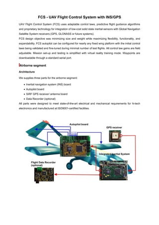
  • 1. FCS - UAV Flight Control System with INS/GPS UAV Flight Control System (FCS) uses adaptable control laws, predictive flight guidance algorithms and proprietary technology for integration of low-cost solid state inertial sensors with Global Navigation Satellite System receivers (GPS, GLONASS or future systems). FCS design objective was minimizing size and weight while maximizing flexibility, functionality, and expandability. FCS autopilot can be configured for nearly any fixed wing platform with the initial control laws being validated and fine-tuned during minimal number of test flights. All control law gains are field adjustable. Mission set-up and testing is simplified with virtual reality training mode. Waypoints are downloadable through a standard serial port. Airborne segment Architecture We supplies three parts for the airborne segment: • Inertial navigation system (INS) board • Autopilot board • SiRF GPS receiver/ antenna board • Data Recorder (optional) All parts were designed to meet state-of-the-art electrical and mechanical requirements for hi-tech electronics and manufactured at ISO9001-certified facilities.
  • 2. GPS receiver is an integrated receiver/antenna modulus (SiRF StarII/LP chipset) provides inertial system with coordinates information Autopilot board Acquires inertial system data, elaborates the control signals according with the control laws and provides the standard PWM signals to servos. 12 channels are available. The Autopilot Board is compatible with manual remote control and can be engaged/disengaged upon the command. Integrated Inertial System It contains the MEMS sensors (accelerometers and rate sensors) combined into full performance inertial navigation system (INS) aided by GPS receiver and built-in barometric altimeter. The system outputs the attitude and position data and transmits it to the autopilot board. Performance • 3-Dimensional Navigation (latitude, longitude, altitude, time/speed) • 255 Pre-programmed Waypoints • Plan Downloaded via a Serial Interface • Automatic Altitude Hold (geo or baro) • GPS loss tolerant • Adaptable to multiple flight platforms • Control gains adjustable by operator • Onboard data logging (option) • Automatic takeoff and landing (option) • Air Data System (option)
  • 3. Specification Electrical Input voltage VDC 10 ~ 30 Power W (max) 2 Servos voltage VDC 5 Environmental Temperature deg F(deg C) -40 ~ +160 (-40~+70) Vibration/Shock g (survival) 20 Operating ranges Angular rates (max) deg/sec 300 Accelerations (max) g 10 Altitude (max calibrated) ft(km) 15,000 (5) INS/GPS system performance Integrated Accuracy Units GNSS On GNSS Gap 5min GNSS Off Position m RMS 6 (*) 500 (**) Not available Velocity X,Y Velocity m/s RMS 0,2 3 Not available Z Velocity m/s RMS 0,25 0,3 0,4 Pitch and roll Straight Horizontal Flight deg RMS 0,2...0,3 0,2...0,3 0,3…0,5 Normal Maneuvre (***) deg RMS 0,3…0,5 0,3…0,5 0,7…1 Complex Maneuvre (***) deg RMS 1 1 2 Heading (****) deg RMS 0,4 0,4 2 Altitude m 2 2 6 Notes (*) Applies to a standard configuration with GPS receiver Garmin GPS35 (positioning accuracy of 15 m RMS). (**) Assumes straight level flight prior to and during GPS gap. (***) Normal is “pitch and roll less 45 deg”, complex is “pitch and roll 45 deg…75 deg”. (****) Heading is calculated as deviation from the track angle value which is output by GNSS receiver immediately after VITANS initialization. The increments are sensed by IMU.
  • 4. Dynamic Ranges Range Resolution Roll, Pitch deg ±180, ±90 0,05 Accelerations g ±10 10-4 Heading deg 0...360 0,1 Angular rate deg/sec ±150 10-3 Max. calibrated altitude m 6,000 0,2 (for barometric altimeter) ft 18,000 1 Ground Station (designed-to-order) Ground Station allows remote control of UAV, receives and processes navigation data from UAV via the data link, supports flight planning and communicates with the autopilot board on ground via RS232 interface (flight plan upload, system configuration and control laws adjustment). Conventional Remote Control is responsible for Autopilot engagement and disengagement as well as allows manual / remote controlled flight operations during visual contact with UAV. If Data Link is installed, Ground Station can support flight control without visual contact with UAV through proprietary software application with predictive flight guidance and synthetic vision capability. Ground Segment Architecture
  • 5. Software Applications Flight Planning and Analysis The Flight Planning Application allows to design the route by simple clicking on the digital map. The waypoint attributes are: latitude, longitude, altitude and desired ground speed. Flight Analysis Software allows to download the flight data and "playback" the flight to analyze the positioning accuracy as well as attitude stabilization performance Synthetic Vision The 3D flight parameters representation is available as INS/GPS data FCS Applications Accurate and stable attitude and position coordinate determination of an UAV enables the user to recombine the full image from the taken partial pictures in a fast and easy manner. • Fixed wings UAV autopilot • Fixed wings UAV flight stabilization • Remotely Piloted UAV (both fixed and rotary winged)