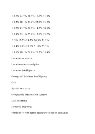
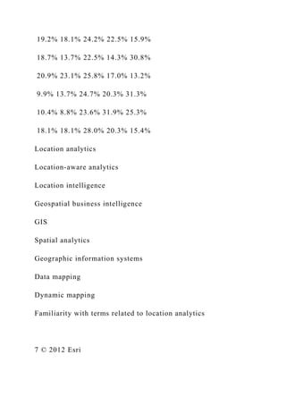
These are just examples from the previous class not for this
week class to know how the takeaways look like.
Example 1:
After reading, “Location Analytics: Bringing Geography Back”,
I thought it was interesting Simon Thompson and Renee
Boucher Ferguson brought up the privacy component among
businesses and consumers. There is a lot of good that can come
from data mining of social media, but it still seems a little
dangerous. It can become intrusive, and that’s where companies
need to be careful. It is incredible the number of patterns, and
trend predictions that can be discovered using geospatial
technology.
After reading, “What is GIS?” I think it is imperative
that businesses of all kinds stay in tuned to a geographic
information system (GIS). GIS helps answer questions by
uniting data from multiple sources on a map. This type of
information may lead benefit companies and organizations
entirely. The information can be used to save on costs, make
better decisions, increase communication, ease geographic
management, and enhance geographic records.
I thought it was noteworthy from, “Location
Analytics: Bringing Geography Back”, that social media is the
ultimate data source. Its crowd sourced, and I found it
interesting that the article discussed social media being tested
to as the definitive answer to what is thought to be known using
intelligent guess work. I notice on in my own feed friends
posting questions, doing their own crowd sourcing, usually to
get the best bang for their buck, or best service locally.
In past classes, I have made numerous bar graphs,
and other charts demonstrating information that I wanted to
display. The chart usually supplemented contextual information
making it easier for the reader to connect the text to real
numbers or statistics. I find it very interesting the power of a
good visual presentation, and how only a few brief seconds is
all that is needed to transmit the intended information. The
unemployment rates of the United States over the years in our
first class was a great example of how viewers get the point,
and don’t have to analyze a chart or figure out a legend.
I found the article, “Mapping the Future” by FastCo
Works very thought-provoking as the growth rate of technology
continues to expand. I thought it was interesting that Esri
spends five times more on research and development than
Apple, at 27% of their total revenue. Huge amounts of data can
now be analyzed and mapped to answer questions quicker than
ever before.
Example 2:
After reading “Location Analytics: Bringing Geography Back”
by Simon Thompson I began to think a lot about what goes into
finding the location for a new store. Thompson had given an
example of how a pharmacy could use customer and location
analysis to determine the best location for a new store. “I can
use location analytics to understand the traffic flows and
demographics, I can analyze the population and make
predictions about prescription medicine”. Being able to analyze
potential customer habits can be very beneficial to determine
the right location. This got me thinking about my hometown and
the location of a specific store. The neighborhood that I live in
is quite large, very spread out; it can take about 20 minutes to
get from the ‘beginning’ to some of the houses deeper in the
neighborhood. The location of this store compared to the next
nearest store is an additional 10 minutes of driving. Our store is
pretty overpriced and I think this is because the owners know
that most people in our neighborhood would rather spend a few
extra dollars, than have a longer drive just to go to a store with
better prices. This shows that the owners must have used some
type of GIS to find their location.
Looking at the Forbes’ “American Migration;
Interactive Map”, it was really interesting to see how people
migrated from different counties during different years. When I
clicked on Los Angeles I could see how many people moved out
of and into the Los Angeles county. I was also able to view the
in-bound and out-bound income per capita within Los Angeles.
When comparing the in-bound income from the years 2007 to
2010 it steadily decreased $3,900 within those four years. I
would have to think the reason for this is because of the 2008
recession.
In the article “Mapping The Future” by Fastco Works,
the author discusses Esri’s maps which are being used by many
successful businesses to find the right locations for their new
stores. One very successful business mentioned was Starbucks.
By using Esri’s maps Starbucks has been very successful at
developing and sustaining stores all over the world. “Large
retailers like Starbucks are using GIS to do site selection with
machine learning. With this technology, they can lay out their
existing successes on the map, overlay that with other layers of
geographic data, then perform advanced statistical analysis that
can guide them toward the most strategic places to locate new
stores”. Anywhere from airports, to downtowns, to busy
shopping malls, Starbucks is one of the leading companies at
being able to develop and maintain profit in over 62 countries
around the world. Part of this success comes from being able to
find the right store location, which is being found using GIS.
I found the “What is GIS” article interesting because it
went into detail about all the different businesses that use GIS
in everyday activities. For example, I never would have thought
that GIS would have been used by the military to help find safe
locations to deploy troops and transfer equipment/materials, or
that GIS was used by search and rescue teams when faced with a
natural disaster. It was also surprising to see organizations like
Homeland Security and law enforcement use these tools; I
would have thought mainly environmental conservationist and
retail suppliers would be using GIS.
While reading about Duarte’s slidedocs it was
interesting to read about how this way of presenting material is
more beneficial than the standard PowerPoint slide when you
graphically want to share information. The author made a good
point of stating that “people learn concepts better when they see
pictures combined with prose”. This makes sense because if you
are trying to describe aspects of a map of chart to someone you
want a combination of the words and the visuals together to
help display the information as a whole.
Using GIS in Business
Week #2 Learning Journal
Write 5 “takeaways” from the files below. This is intended to be
a reflective process, so each of your five takeaways should be
explained in its own paragraph, using full sentences. If
something is interesting or useful to you, try to explain why.
Spelling, capitalization, and grammar count! Also, all posts
should be courteous and professional. No Plagiarism, and please
simplifying your language
Each takeaway should be in 1 paragraph. Each paragraph should
be around 4 lines.
Takeaway #1: find something interesting in this article below
and explain why:
Takeaway #2: find something interesting in this article below
and explain why:
Takeaway #3: find something interesting in this video in the
link below and explain why:
http://www.gapminder.org/videos/200-years-that-changed-the-
world-bbc/
Takeaway #4: find something interesting in this article below
and explain why:
Takeaway #4: find something interesting in this article below
and explain why:
Localization:
Not Just Location
October 2012
2Localization: Not Just Location October 2012
3 GIS for Localization: Not Just Location
4 Understand Local Markets and Develop Winning
Strategies
4 Localization, Not Location
4 Customers Are Their Locations
5 Bring the Store to the Customer
6 The Circle of Life
7 Don’t Just Get Answers—Get Answers That Matter
8 Geography Matters—Market Correctly to the Correct
Market
9 Think Localization
9 Localization, Not Just Location,
Is No. 1 in Real Estate
10 Customers Are Their Locations
10 A “Lightbulb” Moment
11 Have Your Cake and Eat It Too
12 Becoming a More Self-Sufficient Marketplace
14 The Importance of Knowing Your Neighbor
15 How Do You Measure Store Visits?
16 Letting the Customer Take Charge
19 Esri’s 2010/2015 Updated Demographics Data
19 Income
19 Housing
20 Population
20 Diversity
Table of Contents
3GIS for Localization: Not Just LocationLocalization: Not Just
Location October 2012
Localization is very important and provides the mechanisms to
improve both the effectiveness and efficiency of any operation.
Understanding varying nuances in different neighborhoods can
help businesses reach across their many units and systems and
find a united way of operating more efficiently. This process
should ultimately provide the correct amount of proper goods
and services in the right place at the right time. A huge task
in itself, redefining processes and systems can be more of a
challenge in a recession.
Tailoring product offerings to shoppers on a store-by-store basis
is more effective than a one-size-fits-all approach. Empowering
local store managers and real estate departments with decision-
making power leads to success. The key is holding the right
tools
and knowledge framework for a successful business strategy.
But the time to shift is now—understanding buyers’ cautious
spending habits and pinpointing pockets of growth now mean
opportunities can be found; performance optimized; and,
ultimately, returns maximized.
This is evident across all sectors of business. In this e-book, we
bring you articles on how both businesses and communities
benefit from knowing their local markets better. Even in
the financial marketplace, understanding where risks and
policyholders are located leads to more accurate and fair
pricing.
This saves everyone money.
GIS for Localization: Not Just Location
Localization: Not Just Location October 2012 4Understand
Local Markets and Develop Winning Strategies
It’s 9:15—no, not the time we are thinking about our second cup
of coffee, but September 15, 2008, the day Lehman Brothers
filed
the largest bankruptcy petition in U.S. history and the starting
point of the global financial crisis. For many of us, this is the
day
the world changed forever. It turned much of our thinking about
how we run successful businesses on its head and brought about
new realities.
Two years after the onset of the greatest recession in modern
history, there is a new kind of normal. We have new consumer
behavior, revised expectations, innovative ways of doing
business, and different opportunities. GIS software is one of the
technologies that has helped organizations survive and thrive in
the face of all this change. By finding new strategies and a
better
understanding of different drivers in local markets and the
global
economy, the commercial industry is empowered with more
accurate information and is forging new directions.
Localization, Not Location
Today, consumers are holding the cards. It’s no longer a case
of “build it, and they will come.” Overinflated expectations of
store numbers, profit margins, and gross revenues during the
boom years have been replaced with conservative management,
controlled build-out, and revised business strategies. Every
aspect of driving success and maximizing return on investment
is location dependent. Localizing merchandise and correctly
configuring sites to maximize profits based on the profile of the
people in an area and their needs are significant challenges in
today’s economy. This is where GIS is helping. Localization is
the mechanism to balance market opportunity with supply and
demand. To do this, owners and managers need to be able to
apply a range of geographic analysis, models, and knowhow.
Accurately modeling potential requires better techniques as
chain operators seek growth and profitability from fewer,
better-
located stores.
Customers Are Their Locations
Markets are not uniform, nor is their potential. Markets vary
based
on what is already available; what they can support
economically;
the types of people in the catchment; and the predominant
flavor,
lifestyle, or culture of the area. Physical infrastructure like
roads
and transit networks, together with transportation barriers,
limits
access and defines whether intersections and destination points
are attractive. Cities can change many factors by modifying
Understand Local Markets and
Develop Winning Strategies
Localization: Not Just Location October 2012 5Understand
Local Markets and Develop Winning Strategies
the transportation networks and building new roads, but retail
developments are often organic. Retailers are not part of a
master
plan; instead, they compete against each other for locations,
often pitting neighborhoods in opposition.
The traditional approach to defining markets based on a primary
trade area is out of date. Anyone analyzing actual customer data
struggles to find that elusive boundary where a customer goes to
one store instead of another.
It’s almost impossible to consistently predict sales using
primary
trade areas, but business owners have become so used to them
that they are willing to put up with the failures. Or are they?
Where customers live or work is not necessarily where they
buy something. Purchasing behavior and shopper frequency
are driven by convenience. Organizations need to capture and
understand shopping habits, not just buying habits. It’s no
longer acceptable to use the distance from a store as a model
of changes in sales potential or increased competition. The
distributions of sales for real-world stores are too divergent and
diverse to continue with this historic technique. Today,
overbuilt
means overexposed.
Bring the Store to the Customer
Given the varying demographic profile of customers, how does
one individualize the store, restaurant, or service center to
provide the one-to-one, personalized experience consumers now
demand? In a world where cheap is chic and coupons are cool,
how does a franchise succeed with fewer loyal, value-oriented
customers who are trading down and expecting much more?
Business owners need to understand not only whether a business
is in the right place but also whether there’s suitable business
for that market. This is where local owners and operators are
so important. Owners and operators are the front line in any
neighborhood; they care about the local area because they
live there, too. They know the neighborhood and customer
tastes and have daily exposure to habits and changing behavior.
Investing personal assets to create and maintain a business
Reviewing demographic reports by geography gives a much
more accurate
picture of the landscape for business owners and operators.
Localization: Not Just Location October 2012 6Understand
Local Markets and Develop Winning Strategies
ensures that owners and operators of franchises think long and
hard about their every decision.
Smart organizations are using location analysis to empower
local
operators to use profiles of the people in an area to localize
merchandise and correctly configure stores to maximize profits.
From beverage selections to localized price promotions and
location marketing, getting the product and service mix right
affects the bottom line every time. That means configuring the
format and size of the store to different market needs, providing
product choices, and sometimes even moving to a new location
to reduce competition and optimize revenues.
The Circle of Life
Today’s GIS technology embraces the modern, consumer-
oriented world that we all experience every day. iPhone apps
and
web-based applications let potential businesses use GIS without
training and with minimal financial outlay. Market research;
customer analytics; and the creation of extensive demographic,
spending, and income reports let anyone in the franchise
industry
understand surplus and demand in specific locations and create
forward-looking plans. A wide range of analytic techniques and
sophisticated models has been published by experts and is
available via a few mouse clicks. Ranking and scoring a market
or franchise territory are now easier than ever. Since this data is
continually updated, businesses stay current with market
changes
and variations in economic factors.
The benefits don’t stop there. GIS is applicable throughout the
business life cycle. Initially, the technology helps in site
selection
and market planning by helping owners and operators match
opportunity with budgets and expectations. As a retail network
matures, GIS helps optimize the growth strategy and maximize
returns from investment by creating more efficient systems
and optimal store placement. Using GIS, businesses not only
The traditional approach to defining markets based on a primary
trade
area is out of date. Anyone analyzing actual customer data
struggles to
find that elusive boundary where a customer goes to one store
instead of
another. GIS can help.
7Understand Local Markets and Develop Winning
StrategiesLocalization: Not Just Location October 2012
understand where and how they should expand but can also
better manage the scale, format, and pace of expansion.
“Giving people the opportunity to own items they
need, from washers and dryers to nice, quality
furniture, helps them take care of their families.”
Charles A. McClure,
Chairman of McClure Partners
Using these tools, many franchises have outperformed other
industry sectors during the recent recession. Better insight into
changing income and age profiles, house valuation, disposable
incomes, lifestyles, spending patterns, and consumer habits
have helped companies tune their franchises to match consumer
demand. By doing so, many have enjoyed increased gross
margin, reduced inventory, and enhanced customer loyalty and
have balance sheets that are much healthier than many analysts
predicted.
Don’t Just Get Answers—Get Answers That Matter
Even in an economy that has slowed, GIS is helping business
owners and operators understand their long-term potential,
manage the bottom line, and align operations with opportunity.
Better business decisions are made asking the right questions.
With GIS, franchisees and franchisors get answers that matter.
The technology helps test hunches and investigate scenarios
with real-world data using insight gained from information and
experience. Whether it is used to look at the possibilities for
one
location or develop growth strategies for an entire store
network,
GIS can unlock the market potential of areas and reveal what
the
expectations are for each. For more information, visit esri.com
/business.
As an enabler of marketing insight, GIS provides a detailed
view into the
potential performance of a business under different market
conditions
and economic factors.
http://www.esri.com/business
8Understand Local Markets and Develop Winning
StrategiesLocalization: Not Just Location October 2012
Geography Matters—Market Correctly
to the Correct Market
As anyone who has ever owned a business knows, being in
the right location is just the beginning of a successful business.
McClure Partners, a full-service real estate brokerage and
development company based in Dallas, Texas, has tapped
into the power of GIS to create a successful business by
understanding and helping improve local marketplaces. The
company relies on GIS to open franchises in areas thought to
be high-risk segments of the U.S. market. By understanding the
market opportunity and current performance and demographic
data, along with geographic aspects such as competition, streets,
and service areas, McClure Partners has successfully opened
a number of Chili’s restaurant franchises in locations others
deemed unprofitable.
GIS has also helped the company successfully invest in markets
for Aaron’s Inc., a company specializing in leasing furniture
and
electronics. McClure Partners uses the same business techniques
and models to find the best places to open Aaron’s stores in
areas that have historically been written off because of low
income and unemployment. Bringing in new businesses like
these revitalizes communities and brings growth to
economically
stagnant areas.
“Giving people the opportunity to own items they need, from
washers and dryers to nice, quality furniture, helps them take
care
of their families,” says Charles A. “Mac” McClure, chairman of
McClure Partners. “They have a sense of pride that translates
into
taking care of their homes, cleaning up streets, and making their
neighborhoods better places to live.”
(This article originally appeared in the Winter 2010/2011 issue
of
BusinessGeoInfo.)
This targeted ZIP Code-level marketing analysis was developed
by Pueblo
County, Colorado, for online advertising to pinpoint certain
demographic
segments of New York City.
9Think LocalizationLocalization: Not Just Location October
2012
“Retail localization” is a phrase that is being bandied about
more
and more in commercial business. What exactly does it mean?
If done correctly, retail localization means delivering the right
type and volume of products or services to customers within
a particular location by understanding the nuances of that
area. This recently happened in Esri’s hometown of Redlands,
California, where the chamber of commerce used Esri Business
Analyst Online (BAO) software and data to provide
demographic
information about the surrounding communities that prompted
the Dussin Group to open an Old Spaghetti Factory restaurant in
a vacant building.
Markets vary by what is already available; what they can
support
economically; and the predominant “flavor,” or lifestyle, of the
area. GIS technology can be used to better understand the
specific demographics and preferences in individual market
areas
by visualizing that data in an easy-to-understand format: a map.
Instead of sifting through reams of tabular data, being able to
see where particular types of people are located makes business
decisions more accurate. GIS can be applied to retail
localization
in four areas of commercial business: real estate,
merchandising,
marketing, and the supply chain.
Localization, Not Just Location,
Is No. 1 in Real Estate
Using GIS for retail localization positively affects commercial
real
estate by optimizing the placement of stores for the best market
reach, helping evaluate sites, and improving market analysis. It
is important to have the right type of operation in the correct
Think Localization
GIS Helps Retailers Better Understand Local Markets
Esri Business Analyst GIS software and data provide in-depth
knowledge
to understand even small nuances among different
neighborhoods.
10Think LocalizationLocalization: Not Just Location October
2012
location. Understanding the market means knowing whether an
organization should enter, exit, or expand in it.
Real estate is a no-brainer for GIS; looking at geography
means looking at location. Viewing available sites, along with
other information such as income, households, and supply and
demand, gives the best overall view of the health of a particular
market. A great example of this is Edens & Avant, an owner
and developer of shopping centers on the East Coast. The
company, headquartered in Columbia, South Carolina, helps
clients such as Fresh Market, Whole Foods, Starbucks, and
Target
develop innovative shopping centers. The company uses Esri
Business Analyst to look at existing population and
demographic
information for individual areas by displaying all the
information
clients need on a map. This makes decision making an easy-to-
understand, comprehensive process.
One project, a 61,725-square-foot shopping center development,
went forward only because Edens & Avant was able to
determine
that a large residential base was already in place to support it.
Using GIS to analyze demographic information, the company
found that the population in targeted areas had grown by
50 percent over the past decade. As a result, the new center was
leased and opened on time. David Beitz, an executive with
Edens & Avant, explained to me that without the information to
support this decision and an appropriate way to communicate it,
the project wouldn’t have been as successful.
Customers Are Their Locations
Merchandising is another area where GIS can assist in
localizing
business—and not just for retail operations. Banks need to
understand the loan products they are selling to customers.
Realtors need to match the needs of home shoppers to
the available housing inventory in an area. Insurers need to
understand what risks are in an area to create the best policies.
If
a company does this correctly by understanding the profile of
the
people in an area and what their needs are, demand can be met.
This is achieved by understanding the demographic makeup of
an
area; you aren’t necessarily going to sell a house with a pool to
someone who doesn’t like to swim.
One major manufacturer does this very well by using Business
Analyst to place its products. Since the products are used for
competitive sports, company staff members look at demographic
information, the sales history of their stores, and other factors
including where schools with competitive sports teams are
located. This allows the company to match the correct product
to
each storefront, all the way down to the colors that are needed
for the local teams.
A “Lightbulb” Moment
The third aspect of localization where GIS can help is in
marketing.
Think about the coupons the checkout clerk gives you after you
purchase groceries or the offers you receive in the mail. These
11Think LocalizationLocalization: Not Just Location October
2012
are great examples of localizing the marketplace all the way
down
to a personal level; they vary from town to town and consumer
to
consumer.
Puget Sound Energy (PSE), Washington State’s oldest utility,
put
GIS into practice with a marketing program called Rock the
Bulb.
The utility targeted customers who regularly buy incandescent
lightbulbs with the objective of helping them choose compact
fluorescent lamp (CFL) bulbs instead. Using ArcGIS Desktop,
PSE
honed in on the locations of hardware stores and big-box home
improvement stores and their proximity to existing customers.
If the right threshold was met, an event where customers were
asked to trade their old lightbulbs for new ones was staged.
Using this data in planning and budgeting, PSE was able to
estimate the number of participants that would attend the energy
efficiency events.
Have Your Cake and Eat It Too
Retail operations are also very important when we think about
localizing our business strategies. Sometimes we tend to forget
about the distribution and supply chain, which is the ability to
get products where they need to go at the right time. Having the
right products and services in the right location can ultimately
mean the difference between success, survival, and insolvency.
What’s so wonderful is that GIS can help even the most
localized
business. Productos Ramo S.A., a snack food company in
Puget Sound Energy uses GIS to help reach the right customers
with marketing programs.
12Think LocalizationLocalization: Not Just Location October
2012
Colombia, produces a well-known product called Chocoramo, a
square of cake coated in chocolate. You can’t travel to the area
without seeing Ramo’s freight bicycles on almost every street,
delivering Chocoramo and other snacks to small neighborhood
stores.
GIS is used to create optimum delivery routes for the company’s
700 freight bicycles and trucks. It has also been used to
implement a customer survey to find out exactly how many
cakes are needed to match demand by customers and where
they should be delivered. In addition, the technology is used
to produce sales maps to show company executives exactly
how many and where products are delivered. By using GIS to
implement a door-to-door survey and deliver the appropriate
number of cakes to each city, the company has increased the
clients in each of its sales and distribution zones by 10 percent.
In Bogotá, Colombia, alone, for example, Ramo has found 8,000
new customers. Instead of guessing or extrapolating how many
products might be needed in each zone, the company was able
to find the exact amount of product to meet customer demand.
You can’t get much more localized than that.
Becoming a More Self-Sufficient Marketplace
Doing business locally is becoming a new kind of normal. In
today’s economic climate, retailers can’t afford to guess. They
can’t expect to apply the same sales models to different
geographic markets. They need to understand the differences,
even subtle ones, between each marketplace if they are to
thrive.
Air carrier delays and cancellations from the recent volcano
eruption in Iceland are translating into higher costs for shipped
products. If prices go higher, fewer people may be interested
in buying. If I am a shipper, I’d better ensure that I don’t ship
more goods than can be sold at my locations. If I am a local
businessperson, I will recognize this and look for a more local
product to fill the gap where shipped products have become too
expensive or even unavailable.
GIS helps even local businesses understand exactly how many
products
need to be delivered and to which street corners.
Localization: Not Just Location October 2012 13Think
Localization
Speaking of goods becoming unavailable, in the case of the Gulf
of Mexico oil spill, we will see repercussions on local markets
for
the rest of the year. Here in the United States, the shrimp comes
from Louisiana. Now that this year’s shrimp harvest has been
decimated, Americans may have to find some other type of fish
to eat. Smart retailers will recognize this vacuum and meet my
need with other products.
Events such as these make people stop and think about the fact
that we’ve become heavily reliant on many different products
brought to us through the globalized supply chain. Maybe it’s
time to think differently and act locally. We need to understand
not only whether a business is in the right place but also
whether
it’s the right business to do at those locations.
For more information about using GIS in business, visit
esri.com
/business.
(This article originally appeared in the Fall 2010 issue of
BusinessGeoInfo.)
http://www.esri.com
/business
http://www.esri.com
/business
Localization: Not Just Location October 2012 14The Importance
of Knowing Your Neighbor
Simon Thompson, Esri’s director of commercial business
industry
at Esri, believes retailers should use geographic information
system (GIS) data and software to better understand their
markets because, Dorothy, this isn’t Kansas anymore.
He explains, “On my last trip to Kansas, it wasn’t the wheat
fields
or flatness that amazed me but the repetitive retail landscape. It
seemed that every town was a clone of the one I had just left—
the same restaurant chains, grocers, drugstores, and general
merchants.”
Was it an unholy alliance? Had real estate developers,
government, and retailers reached perfect agreement on what
every town needed and limited the choice to a small menu of
options? “The more I looked, the more I found exceptions,” says
Thompson. “The harder I tried to quantify the way towns were
similar to each other, the more I noticed the differences and
came away relieved that local flavors dominate.”
Doing business locally is the new kind of normal. After years of
building out networks almost without limit, the recent recession
changed everything. Retailers that bucked the trend did so
because they have what their customers want: stores in the right
markets, the right products for their catchment, and enough
sales opportunity to overcome
competition and changing
consumer tastes. Location and
geography-based analysis have
helped companies shift focus
from opening stores to improving
store revenue and creating
better promotions. Coupons
have become cool again. “And
we’re not just clipping them
from the local paper,” explains
Thompson. “We’re willing to get
them online because we benefit
from letting retailers integrate
our online habits with our in-store
purchases.”
The lifeblood of a store is return
customers. With detailed, local
knowledge, retailers can go
beyond segmentation and
customer profiles to individual
characteristics, localized
The Importance of Knowing Your Neighbor
The U.S. Green Building
Council’s Green Building
Information Gateway
is an example of an
application that allows
users to quickly compare
their neighborhood with
other sites anywhere in the
country. In this case, LEED
ratings are being evaluated.
Localization: Not Just Location October 2012 15The Importance
of Knowing Your Neighbor
assortment management, and product-level stratification.
Loyalty
and CRM data come alive, so companies can spot trends and
respond, reduce markdown risks, and improve the balance sheet.
Thompson concludes, “Like Dorothy, I know there’s a journey
that
we need to take to gain courage, a heart, or knowledge. Are we
ready for the challenges on the yellow brick road? I don’t know,
but GIS sure looks like a good weapon against the miseries of
the
Wicked Witch of the Great Recession.”
Do others in the industry agree that having products and
services
that more reflect the local region really help retailers succeed?
How Do You Measure Store Visits?
How often will a customer visit your store if it is 2 minutes
away
from the customer’s home versus 10 minutes away? If there
are less affluent people living near the store and more affluent
people living further from the store, how much business will
you
capture from each? This is a question posed by Jim Stone, the
founder and president of geoVue.
geoVue is a leading provider of market planning and site
selection solutions for operators. The company is located in
Woburn, Massachusetts, and has been around since 1994. Stone
explains, “The increased focus on localization has cast a new
light on a well-established concept in site analysis: the primary
trade area. A primary trade area is generally defined as the
physical boundary that represents some significant proportion of
customers who will frequent a store, usually between 60 and 80
percent. Many techniques have been devised to estimate the size
of a primary trade area for a proposed store including standard
rings, drive times, and probability-based measures using
advanced techniques such as spatial interaction models.”
“If the Wizard of Oz were written today, Dorothy
would probably have her own smartphone.”
Lori Schafer, Executive Adviser
for SAS Institute’s Global Retail Division
According to Stone, there are two major challenges presented by
the use of a single geographic boundary to define a store trade
area:
• What does the region outside the trade area look like, and
does it really represent the remaining sales beyond
60–80 percent?
• Does the probability of patronage change uniformly from
the
store to the edge of the trade area for all stores?
After 15 years of analyzing actual customer data for retailers,
restaurants, and service companies, geoVue has found that it is
almost impossible to consistently predict sales for a store using
a single boundary as the measure of a primary trade area. As
the distance from a store increases, the distributions of sales for
real-world stores are too diverse given the varying quantity and
demographic profile of customers.
Localization: Not Just Location October 2012 16The Importance
of Knowing Your Neighbor
This is where GIS technology and data are so important.
Retailers
can use GIS to move into new areas with techniques such as
geographically weighted regression, geostatistical analysis,
and other models based on continuous measurement of data
across different distances from a store. Primary trade areas may
be useful for visualizing existing customer data, but accurately
modeling potential customers will require better techniques as
chain operators seek growth and profitability from fewer,
better-
located stores.
Letting the Customer Take Charge
“If the Wizard of Oz were written today, Dorothy would
probably
have her own smartphone,” says Lori Schafer, executive adviser
for SAS Institute’s Global Retail Division. Schafer currently
serves
on the board of directors of the National Retail Federation
(NRF)
as well as several public and private retailers and technology
companies.
“Based on Dorothy’s current location, she’d have a GPS-based
app showing her how to navigate the Yellow Brick Road back to
Kansas,” Schafer says. “Along the way, she and her friends
could
use the smartphone to search for the nearest retailer who carried
a heart for the Tin Man, a brain for the Scarecrow, and courage
for the Lion. She’d also use the device to do comparative price
checks; research which retailers were offering incentives; read
reviews from others who purchased those same products; and,
via social media, ask opinions of her family back in Kansas. She
may even use foursquare to become the Mayor of Oz!”
Schafer goes on to explain that in today’s world, Dorothy
would be a typical tech-savvy consumer. Customers are now in
charge, and successful retailers must not only better understand
local customer preferences and differentiate their stores from
competition but also engage with customers on their own terms.
GIS allows retailers to understand the local market more
accurately.
Localization: Not Just Location October 2012 17The Importance
of Knowing Your Neighbor
Today, it’s all about bringing the store to the customer, not
expecting the customer to find a store.
Savvy retailers understand why it is critical to become more
local. They are focusing on understanding neighborhood
demographics and tying customer loyalty, purchase, and
location
data together to tailor assortment, style, size, and even colors
to local customer demand. Responding to local customer needs
is an essential strategy for most retailers. It’s proven to not only
enhance customer satisfaction but also drive incremental sales
and margin.
Schafer points out some examples, such as Macy’s, a chain of
mid-
to high-range department stores found across the United States,
whose core strategic priorities are “differentiating merchandise
assortments and tailoring them to local tastes.” The company’s
“My Macy’s” initiative is all about making its merchandise
specific
to customers’ needs in every store, in every local market.
Or, consider Best Buy, an international retailer of consumer
electronics and entertainment software. This company provides
consumers with access to a store-specific web page for each of
its locations. Its mobile application includes a store locator and
will soon provide the ability to search for a particular item and,
based on a customer’s current geographic location, show in-
stock
positions for nearby stores. Both Best Buy and Macy’s are
testing
a mobile-based customer loyalty program that detects when the
customer is in the store, then presents relevant incentives based
on that customer’s specific profile and location.
Over the past several years, retailers have begun implementing
analytic software to help them tailor marketing to the local
consumer; optimize the price, quantity, and assortment mix
based on customers shopping that particular store; and improve
operational performance by location. Software applications such
as market-basket analysis; demand forecasting; and campaign,
assortment, size, price, and promotion optimization have
become
mainstream in assisting retailers in tailoring merchandising and
marketing to the local consumer.
“To date, GIS has been used mainly by retailers’ real estate
departments for location planning,” states Schafer. “Yet GIS
should also be a key tool used by retailers’ merchandising,
marketing, and operations departments in tailoring assortments,
services, and incentives to local demand.”
“GIS should also be a key tool used by retailers’
merchandising, marketing, and operations
departments in tailoring assortments, services, and
incentives to local demand.”
Lori Schafer
GIS can easily be integrated into these analytic software
solutions
to provide a more precise view of local market conditions.
Consider how much more insight a retailer could get by seeing
Localization: Not Just Location October 2012 18The Importance
of Knowing Your Neighbor
a computerized map showing the precise location of all stores,
complete with a detailed view of competitors’ relative locations
as well as complementary retailers and other services that could
draw more traffic. Demographic, store performance, assortment,
pricing, and customer data associated with each location is only
a
click away.
Retailers and retail solution providers need to fully embrace the
capabilities that GIS can provide. After all, most consumers are
already using GIS on their mobile devices to find what they
want.
Very soon, consumers will be able to type the name of a product
into their smartphones and instantly see the list of local retailers
who have that item in stock, associated price and incentives,
and
directions and drive time. With the rapid surge in GIS-enabled
mobility giving today’s customers all the information they need
in the palm of their hand, retailers need to not only understand
who and where their customers are but also how to optimize
their stores’ merchandise, services, and promotional offerings
for
that customer. There is no better way to know your customers,
assess the marketplace, and improve your business than by
incorporating GIS and location data into your business analysis.
For more information, visit esri.com/retail.
(This article originally appeared in the Winter 2010/2011 issue
of
BusinessGeoInfo.)
http://www.esri.com/retail
Localization: Not Just Location October 2012 19Esri’s
2010/2015 Updated Demographics Data
Retail customers continue to battle the lingering effects of the
recession—unemployment, stagnant household incomes, and
lower housing prices. “Christmas in July” sales, expanded
layaway options, and an earlier back-to-school season are
among the campaigns retailers are launching to entice reluctant
consumers back into their stores to shop. How can retailers
learn about the demographic data trends that will affect their
businesses? Esri’s 2010/2015 Updated Demographics data
reveals
intriguing information about the demographic landscape in the
United States.
Esri’s 2010/2015 Updated Demographics data offers more
than 2,000 data variables, including current-year estimates and
2015 forecasts for 11 different U.S. geographies from national
to block group levels. This data can help identify areas of high
unemployment, adjustments in the housing market, rising
vacancy rates, changes in income and consumer spending,
and increased population diversity. Agencies, businesses, and
organizations can use the data to analyze trends, identify
growth,
and reveal new market opportunities.
“The challenge of successfully weathering the current economy
underscores the importance of having access to accurate
information. Current data can track critical changes and
preclude
the cost of being wrong,” says Lynn Wombold, Esri’s chief
demographer and manager of data development. “Esri pays
close attention to economic and social trends and how they
influence the needs of businesses, consumers, and citizens.”
Income
U.S. households are still feeling the pinch of the recession. The
median household income for 2010 is $54,442, down slightly
from $54,719 in 2009. In 98 percent of U.S. counties, median
household income has declined. Average household income
dropped even more, falling from $71,437 to $70,135.
Housing
The first quarter of 2010 saw foreclosures jump by 16 percent
over
the comparable period in 2009. Short sales are still impacting
the
market in some areas. Housing unit vacancies rose by 7.4
percent,
pushing the overall U.S. vacancy rate to nearly 12 percent.
Esri’s 2010/2015 Updated Demographics Data
Recovery Slowed by Lackluster Income, Cautious Spending,
Rising Unemployment, and Low Housing Prices
Localization: Not Just Location October 2012 20Esri’s
2010/2015 Updated Demographics Data
Population
The U.S. population continues to change and diversify.
Population
growth and change slowed in most markets due to fewer births
and the inability to move. Ten states, including Florida and
Michigan, lost population from 2009 to 2010; more than half of
all
U.S. counties also lost population.
Diversity
The most diverse states in 2010 are California, Hawaii, New
Mexico, Texas, and Nevada. At 50.5 million, Hispanics now
comprise 16.2 percent of the total U.S. population. From 2000
to 2010, this segment grew at an annual rate of 3.5 percent. The
Asian population rose and now stands at 14.1 million,
comprising
4.5 percent of the U.S. population. This segment grew at an
annual rate of 3.2 percent from 2000 to 2010. Now numbering
Median household income declined in 98 percent of U.S.
counties. Growth of the Hispanic population is the greatest in
counties in Texas,
California, and New Mexico.
Localization: Not Just Location October 2012 21Esri’s
2010/2015 Updated Demographics Data
9.3 million people and 3 percent of the U.S. total, the 2010
multiracial population also expanded and grew at an annual rate
of 3.1 percent from 2000 to 2010.
Esri’s 2010/2015 Updated Demographics data is available as
database variables and in Esri Business Analyst products
(online,
on desktops and servers, and in an iPhone app); see esri.com/
businessanalyst.
For more information about Esri’s 2010/2015 Updated
Demographics data, visit esri.com/demographicdata or call
1-800-447-9778.
(This article originally appeared in the Fall 2010 issue of
BusinessGeoInfo.)
http://www.esri.com/businessanalyst
http://www.esri.com/demographicdata
Copyright © 2012 Esri
All rights reserved.
Printed in the United States of America.
The information contained in this document is the exclusive
property of Esri. This work is protected under United States
copyright law and other international copyright treaties and
conventions. No part of this work may be reproduced or
transmitted in any form or by any means, electronic or
mechanical, including photocopying and recording, or by any
information storage
or retrieval system, except as expressly permitted in writing by
Esri. All requests should be sent to Attention: Contracts and
Legal Services Manager, Esri, 380 New York Street, Redlands,
CA 92373-8100, USA.
The information contained in this document is subject to change
without notice.
US Government Restricted/Limited Rights
Any software, documentation, and/or data delivered hereunder
is subject to the terms of the License Agreement. The
commercial license rights in the License Agreement strictly
govern Licensee’s use, reproduction, or disclosure of the
software, data, and documentation. In no event shall the US
Government acquire greater than RESTRICTED/LIMITED
RIGHTS. At a minimum,
use, duplication, or disclosure by the US Government is subject
to restrictions as set forth in FAR §52.227-14 Alternates I, II,
and III (DEC 2007); FAR §52.227-19(b) (DEC 2007) and/or
FAR §12.211/12.212 (Commercial Technical Data/Computer
Software); and DFARS §252.227-7015 (DEC 2011) (Technical
Data – Commercial Items) and/or DFARS §227.7202
(Commercial Computer
Software and Commercial Computer Software Documentation),
as applicable. Contractor/Manufacturer is Esri, 380 New York
Street, Redlands, CA 92373-8100, USA.
Esri Trademarks and Service Marks:
@esri.com, 3D Analyst, ACORN, Address Coder, ADF, AML,
ArcAtlas, ArcCAD, ArcCatalog, ArcCOGO, ArcData, ArcDoc,
ArcEdit, ArcEditor, ArcEurope, ArcExplorer, ArcExpress,
ArcGIS, ArcGlobe, ArcGrid, ArcIMS, ARC/INFO, ArcInfo,
ArcInfo Librarian, ArcLessons, ArcLocation, ArcLogistics,
ArcMap, ArcNetwork, ArcNews, ArcObjects, ArcOpen, ArcPad,
ArcPlot, ArcPress,
ArcPy, ArcReader, ArcScan, ArcScene, ArcSchool, ArcScripts,
ArcSDE, ArcSdl, ArcSketch, ArcStorm, ArcSurvey, ArcTIN,
ArcToolbox, ArcTools, ArcUSA, ArcUser, ArcView,
ArcVoyager, ArcWatch, ArcWeb, ArcWorld, ArcXML, Atlas
GIS, AtlasWare, Avenue, BAO, Business Analyst, Business
Analyst Online, BusinessMAP, CommunityInfo, Database
Integrator, DBI Kit, EDN, Esri, Esri—
Team GIS, Esri—The GIS Company, Esri—The GIS People,
Esri—The GIS Software Leader, FormEdit, GeoCollector,
Geographic Design System, Geography Matters, Geography
Network, GIS by Esri, GIS Day, GIS for Everyone, GISData
Server, JTX, MapIt, Maplex, MapObjects, MapStudio,
ModelBuilder, MOLE, MPS—Atlas, PLTS, Rent-a-Tech, SDE,
SML, Sourcebook·America,
SpatiaLABS, Spatial Database Engine, StreetMap, Tapestry, the
ARC/INFO logo, the ArcGIS logo, the ArcGIS Explorer logo,
the ArcPad logo, the Esri globe logo, the Esri Press logo, the
GIS Day logo, the MapIt logo, The Geographic Advantage, The
Geographic Approach, The World’s Leading Desktop GIS,
Water Writes, arcgis.com, esri.com, geographynetwork.com,
gis.
com, gisday.com, and Your Personal Geographic Information
System are trademarks, service marks, or registered trademarks
or service marks of Esri in the United States, the European
Community, or certain other jurisdictions.
Other companies and products mentioned herein may be
trademarks or registered trademarks of their respective
trademark owners.
Printed in USA
Contact Esri
380 New York Street
Redlands, California 92373-8100 usa
1 800 447 9778
t 909 793 2853
f 909 793 5953
[email protected]
esri.com
Offices worldwide
esri.com/locations
Esri inspires and enables people to positively impact their
future
through a deeper, geographic understanding of the changing
world around them.
Governments, industry leaders, academics, and
nongovernmental
organizations trust us to connect them with the analytic
knowledge they
need to make the critical decisions that shape the planet. For
more than
40 years, Esri has cultivated collaborative relationships with
partners
who share our commitment to solving earth’s most pressing
challenges
with geographic expertise and rational resolve. Today, we
believe that
geography is at the heart of a more resilient and sustainable
future.
Creating responsible products and solutions drives our passion
for
improving quality of life everywhere.
G52756 ESRI10/12ek
GIS for Localization: Not Just LocationUnderstand Local
Markets and Develop Winning StrategiesLocalization, Not
LocationCustomers Are Their LocationsBring the Store to the
CustomerThe Circle of LifeDon’t Just Get Answers—Get
Answers That MatterGeography Matters—Market Correctly to
the Correct MarketThink LocalizationLocalization, Not Just
Location,
Is No. 1 in Real EstateCustomers Are Their LocationsA
“Lightbulb” MomentHave Your Cake and Eat It TooBecoming a
More Self-Sufficient MarketplaceThe Importance of Knowing
Your NeighborHow Do You Measure Store Visits?Letting the
Customer Take ChargeEsri’s 2010/2015 Updated Demographics
DataIncomeHousingPopulationDiversity
business-intelligen
ce-location-analytics.pdf
Answering the ‘Where’ in Your BI
How Are Maps Used?
Let Us Count the Ways…
A Disconnect Between Perceived
Value and Prioritization
Making Do Instead of Being Strategic
Users Are Behind in Their Awareness
Conclusion
About Esri
Click to navigate
© 2012 Esri
Revealing the ‘Where’ of Business
Intelligence using Location Analytics
Brought to you compliments of: Increasingly, data is viewed as
the lifeblood of organizations. Across industries, information is
sliced, diced and analyzed for trends, anomalies and insights
that lead to better outcomes and
strategies. In support of this, more and more organizations have
adopted business intelligence
(BI) solutions that help them fully capitalize on the data at their
fingertips. In fact, according to
Gartner, the worldwide market for BI platforms, analytics
applications and performance manage-
ment software market grew to $12.2 billion in 2011. Moreover,
a recent Gartner survey found
that CIOs list BI and analytics technology as their No. 1 priority
for 2012.1
It’s no surprise that these BI tools are increasingly used in
conjunction with enterprise applica-
tions such as customer relationship management, enterprise
resource planning and enterprise
asset management, to name a few. By applying an analytics
layer to these mission-critical
applications, organizations derive greater value from the data
they gather. Plucking new insights
from and making more use of the data at their disposal helps
businesses boost the ROI on these
significant software investments.
That said, in a 2010 IBM/MIT Sloan Management Review
survey of 3,000 executives across
30 industries in 100 countries, 60 percent of respondents said
they have more data than they can
effectively use.2 And most organizations are missing out on a
tremendous opportunity to bring
a richer dimension to their data, namely in the form of location-
specific information related to
their businesses. While organizations capture a vast amount of
data associated with locations
(for example, store fronts, service centers, warehouse addresses
and sales territories), many
are unaware of its value or struggle to make use of it. As such,
they put themselves at a
competitive disadvantage.
Market Research Brief
2 © 2012 Esri
Market Research Brief
Answering the ‘Where’ in Your BI
How Are Maps Used?
Let Us Count the Ways…
A Disconnect Between Perceived
Value and Prioritization
Making Do Instead of Being Strategic
Users Are Behind in Their Awareness
Conclusion
About Esri
Click to navigate
A TechTarget/Esri 2012 survey of more than 180 business and
IT managers and staff at organiza-
tions of all sizes across multiple industries reveals some
important trends and insights when it
comes to location-based data:
• The use of maps to view business data in its geographical
context is growing in importance.
• Managersand executives find it important to
map data to manage everything from assets
and customers to the field workforce and supply chains, as well
as for operational aware-
ness, real estate planning and risk management.
• A gap exists between the growing awareness of
the importance of location-based data
and the ability of organizations to make effective use of the
data.
• While many organizations use simple online
mapsto view the location component
of their business data, far too many still rely on ad hoc tools
versus applications
designed to analyze the geographic relationships in BI data.
• Most respondents associate data mapping with
traditional geographic information systems
(GIS) rather than with the newest generation of BI-specific GIS
tools available to support
this mapping.
This research brief further explores these issues and provides
insight into why organizations
may be struggling — or overlooking the opportunity — to take
advantage of all the data
in their environment.
Answering the ‘Where’ in Your BI
For years, organizations have relied on business intelligence
tools to delve into their data and
unearth important insights that inform better decisions. With
these tools, they’re able to determine
what happened and when. Yet it’s as if these organizations have
been sitting on a two-legged
stool. After all, virtually every important question in an
organization is asked in the context of
“where,” the third leg in any well-balanced stool. As Deloitte
says, “Time and place underpin
everything that happens in our lives and everything we know
and learn about the world. Today’s
technology allows us to collect information about nearly all of
these events, fueling an explosion
of real-time, location-aware data.”3
Location analytics is the use of tools that enable organizations
to visualize the relationship
between corporate data, such as revenues and inventory, and
location-specific data, such as
customer and facility addresses. Specifically, these tools extend
the value of traditional BI appli-
cations by letting people visualize, question, analyze, interpret
and understand data. As a result,
location analytics helps unearth relationships, patterns and
trends that would otherwise remain
locked away.
It’s no surprise that a growing number of organizations are
embracing the concept of location
analytics. In the TechTarget/Esri 2012 survey, just over three-
quarters of respondents said
executives in their organizations feel it’s somewhat or very
important to use maps to view
business data such as store locations, distribution networks,
sales territories, revenue by region
and competitor locations.
3 © 2012 Esri
Market Research Brief
Answering the ‘Where’ in Your BI
How Are Maps Used?
Let Us Count the Ways…
A Disconnect Between Perceived
Value and Prioritization
Making Do Instead of Being Strategic
Users Are Behind in Their Awareness
Conclusion
About Esri
Click to navigate
How Are Maps Used? Let Us Count the Ways…
Managers and executives within these organizations are using
mapped data for a range
of reasons, including:
• Asset management
• Business intelligence
• Customerrelationship management
• Enterprise resource management
• Field workforce management
• Operational awareness
• Real estate planning
• Risk management
• Supply chain management
While no means an exhaustive list, these examples represent
some of the most common uses
of maps within organizations.
The survey provides insight into how executives and managers
perceive the value of maps
differently in the areas above. The widest divergence was seen
in the following:
• Asset management: Nearly 47 percent of managers
compared with just over 36 percent
of executives view maps as somewhat or very valuable for asset
management.
• Field workforce management: Just over 55 percent of
managers compared with nearly
40 percent of executives see maps as somewhat or very valuable
for field workforce
management.
• Real estate planning: Just over 36 percent of executives
compared with just over
24 percent of managers see maps as somewhat or very valuable
for real estate planning.
• Risk management: Nearly 42 percent of executives
compared with just over 34 percent
of managers see maps as somewhat or very valuable for risk
management.
Importance of viewing data on a map
Don’t know 1.1%
Not very important 23.1%
Very important 36.8%
Somewhat important 39.0%
4 © 2012 Esri
Market Research Brief
Answering the ‘Where’ in Your BI
How Are Maps Used?
Let Us Count the Ways…
A Disconnect Between Perceived
Value and Prioritization
Making Do Instead of Being Strategic
Users Are Behind in Their Awareness
Conclusion
About Esri
Click to navigate
These results may be due to the fact that executives and
managers have different organizational
responsibilities and priorities. In other words, managers may be
more focused on asset and field
workforce management than executives, while executives may
be more concerned with real
estate planning and risk management than their managers.
A Disconnect Between Perceived Value and Prioritization
In spite of the growing importance of using maps to understand
the “where” associated with
business activities, the majority of organizations view mapping
of business intelligence activities
as a “nice to have” capability versus an essential one.
Specifically:
• Less than 10 percent of respondents see
mapping as unimportant.
• One-third view it as essential.
• More than half view it as “nice to have.”
Not surprisingly, many of those who view mapping as essential
work in industries that have
historically relied on location-related data:
energy/utilities/telecom, government/federal,
healthcare and retail.
The following are examples of how these industries typically
use this type of data:
• Energy/utilities/telecom: to pinpoint the best locations for
exploration and expansion
• Governments: to analyze population trends and resource
utilization
• Healthcare: to track infectious diseases and analyze
healthcare demands according
to populations
• Retail: to perform site selection and market analysis
The role of mapping in business intelligence activities
Don’t know 1.6%
Unimportant 9.3% Essential 33.0%
Nice to have 56.0%
5 © 2012 Esri
Market Research Brief
Answering the ‘Where’ in Your BI
How Are Maps Used?
Let Us Count the Ways…
A Disconnect Between Perceived
Value and Prioritization
Making Do Instead of Being Strategic
Users Are Behind in Their Awareness
Conclusion
About Esri
Click to navigate
Making Do Instead of Being Strategic
This prevailing attitude of mapping as a “nice to have” may
help explain why most survey
respondents rely on online tools or ad hoc means to view the
location component of their
business data. In spite of the actionable business intelligence to
be derived from this data:
• Over 35 percent use online tools
• Nearly 20 percent view this data in an ad hoc manner
using spreadsheets, presentations, etc.
• Just over 13 percent use mapping tools within
their BI solution
• Just over 12 percent don’t use any tools or
don’t know what tools are used
• Over 10 percent use custom tools/APIs
• Just over 2.5 percent use commercial off-the-shelf
(COTS) solutions
Old habits, the consumerization of IT and general
misconceptions or lack of awareness about
location analytics may help explain the fact that location
mapping is viewed as a “nice to have.”
For decades, organizations have tried to use spreadsheets and
other general tools to make sense
of their data — despite countless studies showing the inefficacy
of such an approach. At the
same time, people often call upon the tools they use outside of
work to do their jobs, so it’s
logical that they would turn to online tools when trying to make
sense of location-specific data
in their organizations.
Moreover, in organizations where location analytics is seen as
“nice to have” versus essential,
there’s likely little push to adopt more robust tools for viewing
location-related data. As a result,
many users turn to freely available, simple mapping tools or
preconfigured graphic representations
of maps. Finally, the relative newness of location analytics is
another key reason for the slow
adoption of advanced tools, such as those embedded within BI
solutions. Yet, according to
Directions Magazine, “… in 2004, integration of location and
BI tools was hardly discussed;
now it’s considered a must in all BI solutions.”4
Means used to view the location component of business data
None/Don’t know 12.1%
Ad hoc from spreadsheets,
presentations, etc. 19.8%
Online tools 35.2%
Others (please specify): 6.6%
Custom tools/APIs 10.4%
COTS solutions 2.7%
Mapping tools within
our BI solution 13.2%
6 © 2012 Esri
Market Research Brief
Answering the ‘Where’ in Your BI
How Are Maps Used?
Let Us Count the Ways…
A Disconnect Between Perceived
Value and Prioritization
Making Do Instead of Being Strategic
Users Are Behind in Their Awareness
Conclusion
About Esri
Click to navigate
Users Are Behind in Their Awareness
Table 1 below shows survey respondents’ familiarity with terms
used to describe ways of exploring
geographic data, measured on a scale of 1 to 5, with 5
indicating “most familiar.” More respon-
dents recognized terms such as GIS and geographic information
systems than terms used in
conjunction with tools designed specifically to help visualize
the relationship between corporate
data and location-specific data. In other words, across many
industries, people may be unaware
of the powerful tools available in the market and think it
impractical to add a geographic dimen-
sion to their analysis and reporting.
As Deloitte points out in its Tech Trends 2012 report, early
spatial modeling tools, such as those
used by engineers and other specialists, required proprietary
knowledge, specialized software
and advanced training. Moreover, location-aware data was
scarce and expensive. Plus, it was
time consuming to develop many of the models using these
specialized tools, and as a result,
the underlying data was often out of date by the time a map was
created.
Much has changed in 2012, according to Deloitte. Organizations
have ready access to geographic
data due to the proliferation of mobile, social and sensor-based
sources. Perhaps most important,
today’s analytics tools are easier to use, allowing everyday
users to more readily and intuitively
explore complex data in a visual manner.5
Least Most
1 2 3 4 5
14.8% 20.3% 29.1% 23.1% 12.6%
17.6% 25.3% 29.7% 17.6% 9.9%
13.7% 24.7% 31.9% 18.7% 11.0%
19.2% 18.1% 24.2% 22.5% 15.9%
18.7% 13.7% 22.5% 14.3% 30.8%
20.9% 23.1% 25.8% 17.0% 13.2%
9.9% 13.7% 24.7% 20.3% 31.3%
10.4% 8.8% 23.6% 31.9% 25.3%
18.1% 18.1% 28.0% 20.3% 15.4%
Location analytics
Location-aware analytics
Location intelligence
Geospatial business intelligence
GIS
Spatial analytics
Geographic information systems
Data mapping
Dynamic mapping
Familiarity with terms related to location analytics
7 © 2012 Esri
Market Research Brief
Answering the ‘Where’ in Your BI
How Are Maps Used?
Let Us Count the Ways…
A Disconnect Between Perceived
Value and Prioritization
Making Do Instead of Being Strategic
Users Are Behind in Their Awareness
Click to navigate
Conclusion
As more products and services become commoditized, the time-
to-decision window shrinks and
globalization increases competitive pressures, organizations are
seeking every opportunity to
stand apart from their rivals and improve their top and bottom
lines. The information gathered
across their environments is a gold mine for those that can find
ways to fully extract the valuable
nuggets from the data piles. And progressive organizations
recognize that the next frontier of
competitive differentiation is to be found in exploring and
exploiting the location-based informa-
tion at their disposal.
The key is to tap into today’s advanced tools that make it
possible to capitalize on the location
component of existing corporate data assets. As Deloitte says,
“In the past, only a handful of
geographic information system (GIS) analysts in specific
industries (oil and gas, governmental
agencies, transportation and logistics firms) invested in using
location as an organizing principle
for advanced analysis. New tools and access to data are now
allowing the power of location
to be unleashed across many more business areas and to a much
broader base of users.”6
In fact, with the growing consumption of location-based
consumer services on mobile devices,
it’s only a matter of time before users start demanding the
ability to access location analytics
within their organizations.
About Esri
Since 1969, Esri has been giving customers around the world
the power to think and plan
geographically. The market leader in GIS technology, Esri
software is used in more than 300,000
organizations worldwide including each of the 200 largest cities
in the United States, most
national governments, more than two-thirds of Fortune 500
companies, and more than 7,000
colleges and universities. Esri applications, running on more
than one million desktops and
thousands of Web and enterprise servers, provide the backbone
for the world’s mapping and
spatial analysis. Esri is the only vendor that provides complete
technical solutions for desktop,
mobile, server, and Internet platforms. Visit us at
esri.com/news.
1 TechTarget, BI, analytics and performance management
software sees growth in 2011, May 24, 2012
2 IBM, IBM Transforms Data At Work, Accelerates Big Data
Analytics, October 24, 2011
3 Deloitte, Tech Trends 2012: Elevate IT for digital business,
2012
4 Directions Magazine, Directions Magazine and Oracle Bring
the Power of Place to Business and Government, 2012
5 Deloitte, Tech Trends 2012: Elevate IT for digital business,
2012
6 Ibid
Learn more about integrating Esri
mapping solutions with your BI.
Contact an Esri BI specialist at
[email protected] to get started.
Answering the ‘Where’ in Your BI
How Are Maps Used?
Let Us Count the Ways…
A Disconnect Between Perceived
Value and Prioritization
Making Do Instead of Being Strategic
Users Are Behind in Their Awareness
Conclusion
About Esri
Click to navigate
© 2012 Esri
Revealing the ‘Where’ of Business
Intelligence using Location Analytics
Brought to you compliments of: Increasingly, data is viewed as
the lifeblood of organizations. Across industries, information is
sliced, diced and analyzed for trends, anomalies and insights
that lead to better outcomes and
strategies. In support of this, more and more organizations have
adopted business intelligence
(BI) solutions that help them fully capitalize on the data at their
fingertips. In fact, according to
Gartner, the worldwide market for BI platforms, analytics
applications and performance manage-
ment software market grew to $12.2 billion in 2011. Moreover,
a recent Gartner survey found
that CIOs list BI and analytics technology as their No. 1 priority
for 2012.1
It’s no surprise that these BI tools are increasingly used in
conjunction with enterprise applica-
tions such as customer relationship management, enterprise
resource planning and enterprise
asset management, to name a few. By applying an analytics
layer to these mission-critical
applications, organizations derive greater value from the data
they gather. Plucking new insights
from and making more use of the data at their disposal helps
businesses boost the ROI on these
significant software investments.
That said, in a 2010 IBM/MIT Sloan Management Review
survey of 3,000 executives across
30 industries in 100 countries, 60 percent of respondents said
they have more data than they can
effectively use.2 And most organizations are missing out on a
tremendous opportunity to bring
a richer dimension to their data, namely in the form of location-
specific information related to
their businesses. While organizations capture a vast amount of
data associated with locations
(for example, store fronts, service centers, warehouse addresses
and sales territories), many
are unaware of its value or struggle to make use of it. As such,
they put themselves at a
competitive disadvantage.
Market Research Brief
2 © 2012 Esri
Market Research Brief
Answering the ‘Where’ in Your BI
How Are Maps Used?
Let Us Count the Ways…
A Disconnect Between Perceived
Value and Prioritization
Making Do Instead of Being Strategic
Users Are Behind in Their Awareness
Conclusion
About Esri
Click to navigate
A TechTarget/Esri 2012 survey of more than 180 business and
IT managers and staff at organiza-
tions of all sizes across multiple industries reveals some
important trends and insights when it
comes to location-based data:
• The use of maps to view business data in its geographical
context is growing in importance.
• Managersand executives find it important to
map data to manage everything from assets
and customers to the field workforce and supply chains, as well
as for operational aware-
ness, real estate planning and risk management.
• A gap exists between the growing awareness of
the importance of location-based data
and the ability of organizations to make effective use of the
data.
• While many organizations use simple online
mapsto view the location component
of their business data, far too many still rely on ad hoc tools
versus applications
designed to analyze the geographic relationships in BI data.
• Most respondents associate data mapping with
traditional geographic information systems
(GIS) rather than with the newest generation of BI-specific GIS
tools available to support
this mapping.
This research brief further explores these issues and provides
insight into why organizations
may be struggling — or overlooking the opportunity — to take
advantage of all the data
in their environment.
Answering the ‘Where’ in Your BI
For years, organizations have relied on business intelligence
tools to delve into their data and
unearth important insights that inform better decisions. With
these tools, they’re able to determine
what happened and when. Yet it’s as if these organizations have
been sitting on a two-legged
stool. After all, virtually every important question in an
organization is asked in the context of
“where,” the third leg in any well-balanced stool. As Deloitte
says, “Time and place underpin
everything that happens in our lives and everything we know
and learn about the world. Today’s
technology allows us to collect information about nearly all of
these events, fueling an explosion
of real-time, location-aware data.”3
Location analytics is the use of tools that enable organizations
to visualize the relationship
between corporate data, such as revenues and inventory, and
location-specific data, such as
customer and facility addresses. Specifically, these tools extend
the value of traditional BI appli-
cations by letting people visualize, question, analyze, interpret
and understand data. As a result,
location analytics helps unearth relationships, patterns and
trends that would otherwise remain
locked away.
It’s no surprise that a growing number of organizations are
embracing the concept of location
analytics. In the TechTarget/Esri 2012 survey, just over three-
quarters of respondents said
executives in their organizations feel it’s somewhat or very
important to use maps to view
business data such as store locations, distribution networks,
sales territories, revenue by region
and competitor locations.
3 © 2012 Esri
Market Research Brief
Answering the ‘Where’ in Your BI
How Are Maps Used?
Let Us Count the Ways…
A Disconnect Between Perceived
Value and Prioritization
Making Do Instead of Being Strategic
Users Are Behind in Their Awareness
Conclusion
About Esri
Click to navigate
How Are Maps Used? Let Us Count the Ways…
Managers and executives within these organizations are using
mapped data for a range
of reasons, including:
• Asset management
• Business intelligence
• Customerrelationship management
• Enterprise resource management
• Field workforce management
• Operational awareness
• Real estate planning
• Risk management
• Supply chain management
While no means an exhaustive list, these examples represent
some of the most common uses
of maps within organizations.
The survey provides insight into how executives and managers
perceive the value of maps
differently in the areas above. The widest divergence was seen
in the following:
• Asset management: Nearly 47 percent of managers
compared with just over 36 percent
of executives view maps as somewhat or very valuable for asset
management.
• Field workforce management: Just over 55 percent of
managers compared with nearly
40 percent of executives see maps as somewhat or very valuable
for field workforce
management.
• Real estate planning: Just over 36 percent of executives
compared with just over
24 percent of managers see maps as somewhat or very valuable
for real estate planning.
• Risk management: Nearly 42 percent of executives
compared with just over 34 percent
of managers see maps as somewhat or very valuable for risk
management.
Importance of viewing data on a map
Don’t know 1.1%
Not very important 23.1%
Very important 36.8%
Somewhat important 39.0%
4 © 2012 Esri
Market Research Brief
Answering the ‘Where’ in Your BI
How Are Maps Used?
Let Us Count the Ways…
A Disconnect Between Perceived
Value and Prioritization
Making Do Instead of Being Strategic
Users Are Behind in Their Awareness
Conclusion
About Esri
Click to navigate
These results may be due to the fact that executives and
managers have different organizational
responsibilities and priorities. In other words, managers may be
more focused on asset and field
workforce management than executives, while executives may
be more concerned with real
estate planning and risk management than their managers.
A Disconnect Between Perceived Value and Prioritization
In spite of the growing importance of using maps to understand
the “where” associated with
business activities, the majority of organizations view mapping
of business intelligence activities
as a “nice to have” capability versus an essential one.
Specifically:
• Less than 10 percent of respondents see
mapping as unimportant.
• One-third view it as essential.
• More than half view it as “nice to have.”
Not surprisingly, many of those who view mapping as essential
work in industries that have
historically relied on location-related data:
energy/utilities/telecom, government/federal,
healthcare and retail.
The following are examples of how these industries typically
use this type of data:
• Energy/utilities/telecom: to pinpoint the best locations for
exploration and expansion
• Governments: to analyze population trends and resource
utilization
• Healthcare: to track infectious diseases and analyze
healthcare demands according
to populations
• Retail: to perform site selection and market analysis
The role of mapping in business intelligence activities
Don’t know 1.6%
Unimportant 9.3% Essential 33.0%
Nice to have 56.0%
5 © 2012 Esri
Market Research Brief
Answering the ‘Where’ in Your BI
How Are Maps Used?
Let Us Count the Ways…
A Disconnect Between Perceived
Value and Prioritization
Making Do Instead of Being Strategic
Users Are Behind in Their Awareness
Conclusion
About Esri
Click to navigate
Making Do Instead of Being Strategic
This prevailing attitude of mapping as a “nice to have” may
help explain why most survey
respondents rely on online tools or ad hoc means to view the
location component of their
business data. In spite of the actionable business intelligence to
be derived from this data:
• Over 35 percent use online tools
• Nearly 20 percent view this data in an ad hoc manner
using spreadsheets, presentations, etc.
• Just over 13 percent use mapping tools within
their BI solution
• Just over 12 percent don’t use any tools or
don’t know what tools are used
• Over 10 percent use custom tools/APIs
• Just over 2.5 percent use commercial off-the-shelf
(COTS) solutions
Old habits, the consumerization of IT and general
misconceptions or lack of awareness about
location analytics may help explain the fact that location
mapping is viewed as a “nice to have.”
For decades, organizations have tried to use spreadsheets and
other general tools to make sense
of their data — despite countless studies showing the inefficacy
of such an approach. At the
same time, people often call upon the tools they use outside of
work to do their jobs, so it’s
logical that they would turn to online tools when trying to make
sense of location-specific data
in their organizations.
Moreover, in organizations where location analytics is seen as
“nice to have” versus essential,
there’s likely little push to adopt more robust tools for viewing
location-related data. As a result,
many users turn to freely available, simple mapping tools or
preconfigured graphic representations
of maps. Finally, the relative newness of location analytics is
another key reason for the slow
adoption of advanced tools, such as those embedded within BI
solutions. Yet, according to
Directions Magazine, “… in 2004, integration of location and
BI tools was hardly discussed;
now it’s considered a must in all BI solutions.”4
Means used to view the location component of business data
None/Don’t know 12.1%
Ad hoc from spreadsheets,
presentations, etc. 19.8%
Online tools 35.2%
Others (please specify): 6.6%
Custom tools/APIs 10.4%
COTS solutions 2.7%
Mapping tools within
our BI solution 13.2%
6 © 2012 Esri
Market Research Brief
Answering the ‘Where’ in Your BI
How Are Maps Used?
Let Us Count the Ways…
A Disconnect Between Perceived
Value and Prioritization
Making Do Instead of Being Strategic
Users Are Behind in Their Awareness
Conclusion
About Esri
Click to navigate
Users Are Behind in Their Awareness
Table 1 below shows survey respondents’ familiarity with terms
used to describe ways of exploring
geographic data, measured on a scale of 1 to 5, with 5
indicating “most familiar.” More respon-
dents recognized terms such as GIS and geographic information
systems than terms used in
conjunction with tools designed specifically to help visualize
the relationship between corporate
data and location-specific data. In other words, across many
industries, people may be unaware
of the powerful tools available in the market and think it
impractical to add a geographic dimen-
sion to their analysis and reporting.
As Deloitte points out in its Tech Trends 2012 report, early
spatial modeling tools, such as those
used by engineers and other specialists, required proprietary
knowledge, specialized software
and advanced training. Moreover, location-aware data was
scarce and expensive. Plus, it was
time consuming to develop many of the models using these
specialized tools, and as a result,
the underlying data was often out of date by the time a map was
created.
Much has changed in 2012, according to Deloitte. Organizations
have ready access to geographic
data due to the proliferation of mobile, social and sensor-based
sources. Perhaps most important,
today’s analytics tools are easier to use, allowing everyday
users to more readily and intuitively
explore complex data in a visual manner.5
Least Most
1 2 3 4 5
14.8% 20.3% 29.1% 23.1% 12.6%
17.6% 25.3% 29.7% 17.6% 9.9%
13.7% 24.7% 31.9% 18.7% 11.0%
19.2% 18.1% 24.2% 22.5% 15.9%
18.7% 13.7% 22.5% 14.3% 30.8%
20.9% 23.1% 25.8% 17.0% 13.2%
9.9% 13.7% 24.7% 20.3% 31.3%
10.4% 8.8% 23.6% 31.9% 25.3%
18.1% 18.1% 28.0% 20.3% 15.4%
Location analytics
Location-aware analytics
Location intelligence
Geospatial business intelligence
GIS
Spatial analytics
Geographic information systems
Data mapping
Dynamic mapping
Familiarity with terms related to location analytics
7 © 2012 Esri
Market Research Brief
Answering the ‘Where’ in Your BI
How Are Maps Used?
Let Us Count the Ways…
A Disconnect Between Perceived
Value and Prioritization
Making Do Instead of Being Strategic
Users Are Behind in Their Awareness
Click to navigate
Conclusion
As more products and services become commoditized, the time-
to-decision window shrinks and
globalization increases competitive pressures, organizations are
seeking every opportunity to
stand apart from their rivals and improve their top and bottom
lines. The information gathered
across their environments is a gold mine for those that can find
ways to fully extract the valuable
nuggets from the data piles. And progressive organizations
recognize that the next frontier of
competitive differentiation is to be found in exploring and
exploiting the location-based informa-
tion at their disposal.
The key is to tap into today’s advanced tools that make it
possible to capitalize on the location
component of existing corporate data assets. As Deloitte says,
“In the past, only a handful of
geographic information system (GIS) analysts in specific
industries (oil and gas, governmental
agencies, transportation and logistics firms) invested in using
location as an organizing principle
for advanced analysis. New tools and access to data are now
allowing the power of location
to be unleashed across many more business areas and to a much
broader base of users.”6
In fact, with the growing consumption of location-based
consumer services on mobile devices,
it’s only a matter of time before users start demanding the
ability to access location analytics
within their organizations.
About Esri
Since 1969, Esri has been giving customers around the world
the power to think and plan
geographically. The market leader in GIS technology, Esri
software is used in more than 300,000
organizations worldwide including each of the 200 largest cities
in the United States, most
national governments, more than two-thirds of Fortune 500
companies, and more than 7,000
colleges and universities. Esri applications, running on more
than one million desktops and
thousands of Web and enterprise servers, provide the backbone
for the world’s mapping and
spatial analysis. Esri is the only vendor that provides complete
technical solutions for desktop,
mobile, server, and Internet platforms. Visit us at
esri.com/news.
1 TechTarget, BI, analytics and performance management
software sees growth in 2011, May 24, 2012
2 IBM, IBM Transforms Data At Work, Accelerates Big Data
Analytics, October 24, 2011
3 Deloitte, Tech Trends 2012: Elevate IT for digital business,
2012
4 Directions Magazine, Directions Magazine and Oracle Bring
the Power of Place to Business and Government, 2012
5 Deloitte, Tech Trends 2012: Elevate IT for digital business,
2012
6 Ibid
Learn more about integrating Esri
mapping solutions with your BI.
Contact an Esri BI specialist at
[email protected] to get started.
localization-not-jus
t-location.pdf
Localization:
Not Just Location
October 2012
2Localization: Not Just Location October 2012
3 GIS for Localization: Not Just Location
4 Understand Local Markets and Develop Winning
Strategies
4 Localization, Not Location
4 Customers Are Their Locations
5 Bring the Store to the Customer
6 The Circle of Life
7 Don’t Just Get Answers—Get Answers That Matter
8 Geography Matters—Market Correctly to the Correct
Market
9 Think Localization
9 Localization, Not Just Location,
Is No. 1 in Real Estate
10 Customers Are Their Locations
10 A “Lightbulb” Moment
11 Have Your Cake and Eat It Too
12 Becoming a More Self-Sufficient Marketplace
14 The Importance of Knowing Your Neighbor
15 How Do You Measure Store Visits?
16 Letting the Customer Take Charge
19 Esri’s 2010/2015 Updated Demographics Data
19 Income
19 Housing
20 Population
20 Diversity
Table of Contents
3GIS for Localization: Not Just LocationLocalization: Not Just
Location October 2012
Localization is very important and provides the mechanisms to
improve both the effectiveness and efficiency of any operation.
Understanding varying nuances in different neighborhoods can
help businesses reach across their many units and systems and
find a united way of operating more efficiently. This process
should ultimately provide the correct amount of proper goods
and services in the right place at the right time. A huge task
in itself, redefining processes and systems can be more of a
challenge in a recession.
Tailoring product offerings to shoppers on a store-by-store basis
is more effective than a one-size-fits-all approach. Empowering
local store managers and real estate departments with decision-
making power leads to success. The key is holding the right
tools
and knowledge framework for a successful business strategy.
But the time to shift is now—understanding buyers’ cautious
spending habits and pinpointing pockets of growth now mean
opportunities can be found; performance optimized; and,
ultimately, returns maximized.
This is evident across all sectors of business. In this e-book, we
bring you articles on how both businesses and communities
benefit from knowing their local markets better. Even in
the financial marketplace, understanding where risks and
policyholders are located leads to more accurate and fair
pricing.
This saves everyone money.
GIS for Localization: Not Just Location
Localization: Not Just Location October 2012 4Understand
Local Markets and Develop Winning Strategies
It’s 9:15—no, not the time we are thinking about our second cup
of coffee, but September 15, 2008, the day Lehman Brothers
filed
the largest bankruptcy petition in U.S. history and the starting
point of the global financial crisis. For many of us, this is the
day
the world changed forever. It turned much of our thinking about
how we run successful businesses on its head and brought about
new realities.
Two years after the onset of the greatest recession in modern
history, there is a new kind of normal. We have new consumer
behavior, revised expectations, innovative ways of doing
business, and different opportunities. GIS software is one of the
technologies that has helped organizations survive and thrive in
the face of all this change. By finding new strategies and a
better
understanding of different drivers in local markets and the
global
economy, the commercial industry is empowered with more
accurate information and is forging new directions.
Localization, Not Location
Today, consumers are holding the cards. It’s no longer a case
of “build it, and they will come.” Overinflated expectations of
store numbers, profit margins, and gross revenues during the
boom years have been replaced with conservative management,
controlled build-out, and revised business strategies. Every
aspect of driving success and maximizing return on investment
is location dependent. Localizing merchandise and correctly
configuring sites to maximize profits based on the profile of the
people in an area and their needs are significant challenges in
today’s economy. This is where GIS is helping. Localization is
the mechanism to balance market opportunity with supply and
demand. To do this, owners and managers need to be able to
apply a range of geographic analysis, models, and knowhow.
Accurately modeling potential requires better techniques as
chain operators seek growth and profitability from fewer,
better-
located stores.
Customers Are Their Locations
Markets are not uniform, nor is their potential. Markets vary
based
on what is already available; what they can support
economically;
the types of people in the catchment; and the predominant
flavor,
lifestyle, or culture of the area. Physical infrastructure like
roads
and transit networks, together with transportation barriers,
limits
access and defines whether intersections and destination points
are attractive. Cities can change many factors by modifying
Understand Local Markets and
Develop Winning Strategies
Localization: Not Just Location October 2012 5Understand
Local Markets and Develop Winning Strategies
the transportation networks and building new roads, but retail
developments are often organic. Retailers are not part of a
master
plan; instead, they compete against each other for locations,
often pitting neighborhoods in opposition.
The traditional approach to defining markets based on a primary
trade area is out of date. Anyone analyzing actual customer data
struggles to find that elusive boundary where a customer goes to
one store instead of another.
It’s almost impossible to consistently predict sales using
primary
trade areas, but business owners have become so used to them
that they are willing to put up with the failures. Or are they?
Where customers live or work is not necessarily where they
buy something. Purchasing behavior and shopper frequency
are driven by convenience. Organizations need to capture and
understand shopping habits, not just buying habits. It’s no
longer acceptable to use the distance from a store as a model
of changes in sales potential or increased competition. The
distributions of sales for real-world stores are too divergent and
diverse to continue with this historic technique. Today,
overbuilt
means overexposed.
Bring the Store to the Customer
Given the varying demographic profile of customers, how does
one individualize the store, restaurant, or service center to
provide the one-to-one, personalized experience consumers now
demand? In a world where cheap is chic and coupons are cool,
how does a franchise succeed with fewer loyal, value-oriented
customers who are trading down and expecting much more?
Business owners need to understand not only whether a business
is in the right place but also whether there’s suitable business
for that market. This is where local owners and operators are
so important. Owners and operators are the front line in any
neighborhood; they care about the local area because they
live there, too. They know the neighborhood and customer
tastes and have daily exposure to habits and changing behavior.
Investing personal assets to create and maintain a business
Reviewing demographic reports by geography gives a much
more accurate
picture of the landscape for business owners and operators.
Localization: Not Just Location October 2012 6Understand
Local Markets and Develop Winning Strategies
ensures that owners and operators of franchises think long and
hard about their every decision.
Smart organizations are using location analysis to empower
local
operators to use profiles of the people in an area to localize
merchandise and correctly configure stores to maximize profits.
From beverage selections to localized price promotions and
location marketing, getting the product and service mix right
affects the bottom line every time. That means configuring the
format and size of the store to different market needs, providing
product choices, and sometimes even moving to a new location
to reduce competition and optimize revenues.
The Circle of Life
Today’s GIS technology embraces the modern, consumer-
oriented world that we all experience every day. iPhone apps
and
web-based applications let potential businesses use GIS without
training and with minimal financial outlay. Market research;
customer analytics; and the creation of extensive demographic,
spending, and income reports let anyone in the franchise
industry
understand surplus and demand in specific locations and create
forward-looking plans. A wide range of analytic techniques and
sophisticated models has been published by experts and is
available via a few mouse clicks. Ranking and scoring a market
or franchise territory are now easier than ever. Since this data is
continually updated, businesses stay current with market
changes
and variations in economic factors.
The benefits don’t stop there. GIS is applicable throughout the
business life cycle. Initially, the technology helps in site
selection
and market planning by helping owners and operators match
opportunity with budgets and expectations. As a retail network
matures, GIS helps optimize the growth strategy and maximize
returns from investment by creating more efficient systems
and optimal store placement. Using GIS, businesses not only
The traditional approach to defining markets based on a primary
trade
area is out of date. Anyone analyzing actual customer data
struggles to
find that elusive boundary where a customer goes to one store
instead of
another. GIS can help.
7Understand Local Markets and Develop Winning
StrategiesLocalization: Not Just Location October 2012
understand where and how they should expand but can also
better manage the scale, format, and pace of expansion.
“Giving people the opportunity to own items they
need, from washers and dryers to nice, quality
furniture, helps them take care of their families.”
Charles A. McClure,
Chairman of McClure Partners
Using these tools, many franchises have outperformed other
industry sectors during the recent recession. Better insight into
changing income and age profiles, house valuation, disposable
incomes, lifestyles, spending patterns, and consumer habits
have helped companies tune their franchises to match consumer
demand. By doing so, many have enjoyed increased gross
margin, reduced inventory, and enhanced customer loyalty and
have balance sheets that are much healthier than many analysts
predicted.
Don’t Just Get Answers—Get Answers That Matter
Even in an economy that has slowed, GIS is helping business
owners and operators understand their long-term potential,
manage the bottom line, and align operations with opportunity.
Better business decisions are made asking the right questions.
With GIS, franchisees and franchisors get answers that matter.
The technology helps test hunches and investigate scenarios
with real-world data using insight gained from information and
experience. Whether it is used to look at the possibilities for
one
location or develop growth strategies for an entire store
network,
GIS can unlock the market potential of areas and reveal what
the
expectations are for each. For more information, visit esri.com
/business.
As an enabler of marketing insight, GIS provides a detailed
view into the
potential performance of a business under different market
conditions
and economic factors.
http://www.esri.com/business
8Understand Local Markets and Develop Winning
StrategiesLocalization: Not Just Location October 2012
Geography Matters—Market Correctly
to the Correct Market
As anyone who has ever owned a business knows, being in
the right location is just the beginning of a successful business.
McClure Partners, a full-service real estate brokerage and
development company based in Dallas, Texas, has tapped
into the power of GIS to create a successful business by
understanding and helping improve local marketplaces. The
company relies on GIS to open franchises in areas thought to
be high-risk segments of the U.S. market. By understanding the
market opportunity and current performance and demographic
data, along with geographic aspects such as competition, streets,
and service areas, McClure Partners has successfully opened
a number of Chili’s restaurant franchises in locations others
deemed unprofitable.
GIS has also helped the company successfully invest in markets
for Aaron’s Inc., a company specializing in leasing furniture
and
electronics. McClure Partners uses the same business techniques
and models to find the best places to open Aaron’s stores in
areas that have historically been written off because of low
income and unemployment. Bringing in new businesses like
these revitalizes communities and brings growth to
economically
stagnant areas.
“Giving people the opportunity to own items they need, from
washers and dryers to nice, quality furniture, helps them take
care
of their families,” says Charles A. “Mac” McClure, chairman of
McClure Partners. “They have a sense of pride that translates
into
taking care of their homes, cleaning up streets, and making their
neighborhoods better places to live.”
(This article originally appeared in the Winter 2010/2011 issue
of
BusinessGeoInfo.)
This targeted ZIP Code-level marketing analysis was developed
by Pueblo
County, Colorado, for online advertising to pinpoint certain
demographic
segments of New York City.
9Think LocalizationLocalization: Not Just Location October
2012
“Retail localization” is a phrase that is being bandied about
more
and more in commercial business. What exactly does it mean?
If done correctly, retail localization means delivering the right
type and volume of products or services to customers within
a particular location by understanding the nuances of that
area. This recently happened in Esri’s hometown of Redlands,
California, where the chamber of commerce used Esri Business
Analyst Online (BAO) software and data to provide
demographic
information about the surrounding communities that prompted
the Dussin Group to open an Old Spaghetti Factory restaurant in
a vacant building.
Markets vary by what is already available; what they can
support
economically; and the predominant “flavor,” or lifestyle, of the
area. GIS technology can be used to better understand the
specific demographics and preferences in individual market
areas
by visualizing that data in an easy-to-understand format: a map.
Instead of sifting through reams of tabular data, being able to
see where particular types of people are located makes business
decisions more accurate. GIS can be applied to retail
localization
in four areas of commercial business: real estate,
merchandising,
marketing, and the supply chain.
Localization, Not Just Location,
Is No. 1 in Real Estate
Using GIS for retail localization positively affects commercial
real
estate by optimizing the placement of stores for the best market
reach, helping evaluate sites, and improving market analysis. It
is important to have the right type of operation in the correct
Think Localization
GIS Helps Retailers Better Understand Local Markets
Esri Business Analyst GIS software and data provide in-depth
knowledge
to understand even small nuances among different
neighborhoods.
10Think LocalizationLocalization: Not Just Location October
2012
location. Understanding the market means knowing whether an
organization should enter, exit, or expand in it.
Real estate is a no-brainer for GIS; looking at geography
means looking at location. Viewing available sites, along with
other information such as income, households, and supply and
demand, gives the best overall view of the health of a particular
market. A great example of this is Edens & Avant, an owner
and developer of shopping centers on the East Coast. The
company, headquartered in Columbia, South Carolina, helps
clients such as Fresh Market, Whole Foods, Starbucks, and
Target
develop innovative shopping centers. The company uses Esri
Business Analyst to look at existing population and
demographic
information for individual areas by displaying all the
information
clients need on a map. This makes decision making an easy-to-
understand, comprehensive process.
One project, a 61,725-square-foot shopping center development,
went forward only because Edens & Avant was able to
determine
that a large residential base was already in place to support it.
Using GIS to analyze demographic information, the company
found that the population in targeted areas had grown by
50 percent over the past decade. As a result, the new center was
leased and opened on time. David Beitz, an executive with
Edens & Avant, explained to me that without the information to
support this decision and an appropriate way to communicate it,
the project wouldn’t have been as successful.
Customers Are Their Locations
Merchandising is another area where GIS can assist in
localizing
business—and not just for retail operations. Banks need to
understand the loan products they are selling to customers.
Realtors need to match the needs of home shoppers to
the available housing inventory in an area. Insurers need to
understand what risks are in an area to create the best policies.
If
a company does this correctly by understanding the profile of
the
people in an area and what their needs are, demand can be met.
This is achieved by understanding the demographic makeup of
an
area; you aren’t necessarily going to sell a house with a pool to
someone who doesn’t like to swim.
One major manufacturer does this very well by using Business
Analyst to place its products. Since the products are used for
competitive sports, company staff members look at demographic
information, the sales history of their stores, and other factors
including where schools with competitive sports teams are
located. This allows the company to match the correct product
to
each storefront, all the way down to the colors that are needed
for the local teams.
A “Lightbulb” Moment
The third aspect of localization where GIS can help is in
marketing.
Think about the coupons the checkout clerk gives you after you
purchase groceries or the offers you receive in the mail. These
11Think LocalizationLocalization: Not Just Location October
2012
are great examples of localizing the marketplace all the way
down
to a personal level; they vary from town to town and consumer
to
consumer.
Puget Sound Energy (PSE), Washington State’s oldest utility,
put
GIS into practice with a marketing program called Rock the
Bulb.
The utility targeted customers who regularly buy incandescent
lightbulbs with the objective of helping them choose compact
fluorescent lamp (CFL) bulbs instead. Using ArcGIS Desktop,
PSE
honed in on the locations of hardware stores and big-box home
improvement stores and their proximity to existing customers.
If the right threshold was met, an event where customers were
asked to trade their old lightbulbs for new ones was staged.
Using this data in planning and budgeting, PSE was able to
estimate the number of participants that would attend the energy
efficiency events.
Have Your Cake and Eat It Too
Retail operations are also very important when we think about
localizing our business strategies. Sometimes we tend to forget
about the distribution and supply chain, which is the ability to
get products where they need to go at the right time. Having the
right products and services in the right location can ultimately
mean the difference between success, survival, and insolvency.
What’s so wonderful is that GIS can help even the most
localized
business. Productos Ramo S.A., a snack food company in
Puget Sound Energy uses GIS to help reach the right customers
with marketing programs.
12Think LocalizationLocalization: Not Just Location October
2012
Colombia, produces a well-known product called Chocoramo, a
square of cake coated in chocolate. You can’t travel to the area
without seeing Ramo’s freight bicycles on almost every street,
delivering Chocoramo and other snacks to small neighborhood
stores.
GIS is used to create optimum delivery routes for the company’s
700 freight bicycles and trucks. It has also been used to
implement a customer survey to find out exactly how many
cakes are needed to match demand by customers and where
they should be delivered. In addition, the technology is used
to produce sales maps to show company executives exactly
how many and where products are delivered. By using GIS to
implement a door-to-door survey and deliver the appropriate
number of cakes to each city, the company has increased the
clients in each of its sales and distribution zones by 10 percent.
In Bogotá, Colombia, alone, for example, Ramo has found 8,000
new customers. Instead of guessing or extrapolating how many
products might be needed in each zone, the company was able
to find the exact amount of product to meet customer demand.
You can’t get much more localized than that.
Becoming a More Self-Sufficient Marketplace
Doing business locally is becoming a new kind of normal. In
today’s economic climate, retailers can’t afford to guess. They
can’t expect to apply the same sales models to different
geographic markets. They need to understand the differences,
even subtle ones, between each marketplace if they are to
thrive.
Air carrier delays and cancellations from the recent volcano
eruption in Iceland are translating into higher costs for shipped
products. If prices go higher, fewer people may be interested
in buying. If I am a shipper, I’d better ensure that I don’t ship
more goods than can be sold at my locations. If I am a local
businessperson, I will recognize this and look for a more local
product to fill the gap where shipped products have become too
expensive or even unavailable.
GIS helps even local businesses understand exactly how many
products
need to be delivered and to which street corners.
Localization: Not Just Location October 2012 13Think
Localization
Speaking of goods becoming unavailable, in the case of the Gulf
of Mexico oil spill, we will see repercussions on local markets
for
the rest of the year. Here in the United States, the shrimp comes
from Louisiana. Now that this year’s shrimp harvest has been
decimated, Americans may have to find some other type of fish
to eat. Smart retailers will recognize this vacuum and meet my
need with other products.
Events such as these make people stop and think about the fact
that we’ve become heavily reliant on many different products
brought to us through the globalized supply chain. Maybe it’s
time to think differently and act locally. We need to understand
not only whether a business is in the right place but also
whether
it’s the right business to do at those locations.
For more information about using GIS in business, visit
esri.com
/business.
(This article originally appeared in the Fall 2010 issue of
BusinessGeoInfo.)
http://www.esri.com
/business
http://www.esri.com
/business
Localization: Not Just Location October 2012 14The Importance
of Knowing Your Neighbor
Simon Thompson, Esri’s director of commercial business
industry
at Esri, believes retailers should use geographic information
system (GIS) data and software to better understand their
markets because, Dorothy, this isn’t Kansas anymore.
He explains, “On my last trip to Kansas, it wasn’t the wheat
fields
or flatness that amazed me but the repetitive retail landscape. It
seemed that every town was a clone of the one I had just left—
the same restaurant chains, grocers, drugstores, and general
merchants.”
Was it an unholy alliance? Had real estate developers,
government, and retailers reached perfect agreement on what
every town needed and limited the choice to a small menu of
options? “The more I looked, the more I found exceptions,” says
Thompson. “The harder I tried to quantify the way towns were
similar to each other, the more I noticed the differences and
came away relieved that local flavors dominate.”
Doing business locally is the new kind of normal. After years of
building out networks almost without limit, the recent recession
changed everything. Retailers that bucked the trend did so
because they have what their customers want: stores in the right
markets, the right products for their catchment, and enough
sales opportunity to overcome
competition and changing
consumer tastes. Location and
geography-based analysis have
helped companies shift focus
from opening stores to improving
store revenue and creating
better promotions. Coupons
have become cool again. “And
we’re not just clipping them
from the local paper,” explains
Thompson. “We’re willing to get
them online because we benefit
from letting retailers integrate
our online habits with our in-store
purchases.”
The lifeblood of a store is return
customers. With detailed, local
knowledge, retailers can go
beyond segmentation and
customer profiles to individual
characteristics, localized
The Importance of Knowing Your Neighbor
The U.S. Green Building
Council’s Green Building
Information Gateway
is an example of an
application that allows
users to quickly compare
their neighborhood with
other sites anywhere in the
country. In this case, LEED
ratings are being evaluated.
Localization: Not Just Location October 2012 15The Importance
of Knowing Your Neighbor
assortment management, and product-level stratification.
Loyalty
and CRM data come alive, so companies can spot trends and
respond, reduce markdown risks, and improve the balance sheet.
Thompson concludes, “Like Dorothy, I know there’s a journey
that
we need to take to gain courage, a heart, or knowledge. Are we
ready for the challenges on the yellow brick road? I don’t know,
but GIS sure looks like a good weapon against the miseries of
the
Wicked Witch of the Great Recession.”
Do others in the industry agree that having products and
services
that more reflect the local region really help retailers succeed?
How Do You Measure Store Visits?
How often will a customer visit your store if it is 2 minutes
away
from the customer’s home versus 10 minutes away? If there
are less affluent people living near the store and more affluent
people living further from the store, how much business will
you
capture from each? This is a question posed by Jim Stone, the
founder and president of geoVue.
geoVue is a leading provider of market planning and site
selection solutions for operators. The company is located in
Woburn, Massachusetts, and has been around since 1994. Stone
explains, “The increased focus on localization has cast a new
light on a well-established concept in site analysis: the primary
trade area. A primary trade area is generally defined as the
physical boundary that represents some significant proportion of
customers who will frequent a store, usually between 60 and 80
percent. Many techniques have been devised to estimate the size
of a primary trade area for a proposed store including standard
rings, drive times, and probability-based measures using
advanced techniques such as spatial interaction models.”
“If the Wizard of Oz were written today, Dorothy
would probably have her own smartphone.”
Lori Schafer, Executive Adviser
for SAS Institute’s Global Retail Division
According to Stone, there are two major challenges presented by
the use of a single geographic boundary to define a store trade
area:
• What does the region outside the trade area look like, and
does it really represent the remaining sales beyond
60–80 percent?
• Does the probability of patronage change uniformly from
the
store to the edge of the trade area for all stores?
After 15 years of analyzing actual customer data for retailers,
restaurants, and service companies, geoVue has found that it is
almost impossible to consistently predict sales for a store using
a single boundary as the measure of a primary trade area. As
the distance from a store increases, the distributions of sales for
real-world stores are too diverse given the varying quantity and
demographic profile of customers.
Localization: Not Just Location October 2012 16The Importance
of Knowing Your Neighbor
This is where GIS technology and data are so important.
Retailers
can use GIS to move into new areas with techniques such as
geographically weighted regression, geostatistical analysis,
and other models based on continuous measurement of data
across different distances from a store. Primary trade areas may
be useful for visualizing existing customer data, but accurately
modeling potential customers will require better techniques as
chain operators seek growth and profitability from fewer,
better-
located stores.
Letting the Customer Take Charge
“If the Wizard of Oz were written today, Dorothy would
probably
have her own smartphone,” says Lori Schafer, executive adviser
for SAS Institute’s Global Retail Division. Schafer currently
serves
on the board of directors of the National Retail Federation
(NRF)
as well as several public and private retailers and technology
companies.
“Based on Dorothy’s current location, she’d have a GPS-based
app showing her how to navigate the Yellow Brick Road back to
Kansas,” Schafer says. “Along the way, she and her friends
could
use the smartphone to search for the nearest retailer who carried
a heart for the Tin Man, a brain for the Scarecrow, and courage
for the Lion. She’d also use the device to do comparative price
checks; research which retailers were offering incentives; read
reviews from others who purchased those same products; and,
via social media, ask opinions of her family back in Kansas. She
may even use foursquare to become the Mayor of Oz!”
Schafer goes on to explain that in today’s world, Dorothy
would be a typical tech-savvy consumer. Customers are now in
charge, and successful retailers must not only better understand
local customer preferences and differentiate their stores from
competition but also engage with customers on their own terms.
GIS allows retailers to understand the local market more
accurately.
Localization: Not Just Location October 2012 17The Importance
of Knowing Your Neighbor
Today, it’s all about bringing the store to the customer, not
expecting the customer to find a store.
Savvy retailers understand why it is critical to become more
local. They are focusing on understanding neighborhood
demographics and tying customer loyalty, purchase, and
location
data together to tailor assortment, style, size, and even colors
to local customer demand. Responding to local customer needs
is an essential strategy for most retailers. It’s proven to not only
enhance customer satisfaction but also drive incremental sales
and margin.
Schafer points out some examples, such as Macy’s, a chain of
mid-
to high-range department stores found across the United States,
whose core strategic priorities are “differentiating merchandise
assortments and tailoring them to local tastes.” The company’s
“My Macy’s” initiative is all about making its merchandise
specific
to customers’ needs in every store, in every local market.
Or, consider Best Buy, an international retailer of consumer
electronics and entertainment software. This company provides
consumers with access to a store-specific web page for each of
its locations. Its mobile application includes a store locator and
will soon provide the ability to search for a particular item and,
based on a customer’s current geographic location, show in-
stock
positions for nearby stores. Both Best Buy and Macy’s are
testing
a mobile-based customer loyalty program that detects when the
customer is in the store, then presents relevant incentives based
on that customer’s specific profile and location.
Over the past several years, retailers have begun implementing
analytic software to help them tailor marketing to the local
consumer; optimize the price, quantity, and assortment mix
based on customers shopping that particular store; and improve
operational performance by location. Software applications such
as market-basket analysis; demand forecasting; and campaign,
assortment, size, price, and promotion optimization have
become
mainstream in assisting retailers in tailoring merchandising and
marketing to the local consumer.
“To date, GIS has been used mainly by retailers’ real estate
departments for location planning,” states Schafer. “Yet GIS
should also be a key tool used by retailers’ merchandising,
marketing, and operations departments in tailoring assortments,
services, and incentives to local demand.”
“GIS should also be a key tool used by retailers’
merchandising, marketing, and operations
departments in tailoring assortments, services, and
incentives to local demand.”
Lori Schafer
GIS can easily be integrated into these analytic software
solutions
to provide a more precise view of local market conditions.
Consider how much more insight a retailer could get by seeing
Localization: Not Just Location October 2012 18The Importance
of Knowing Your Neighbor
a computerized map showing the precise location of all stores,
complete with a detailed view of competitors’ relative locations
as well as complementary retailers and other services that could
draw more traffic. Demographic, store performance, assortment,
pricing, and customer data associated with each location is only
a
click away.
Retailers and retail solution providers need to fully embrace the
capabilities that GIS can provide. After all, most consumers are
already using GIS on their mobile devices to find what they
want.
Very soon, consumers will be able to type the name of a product
into their smartphones and instantly see the list of local retailers
who have that item in stock, associated price and incentives,
and
directions and drive time. With the rapid surge in GIS-enabled
mobility giving today’s customers all the information they need
in the palm of their hand, retailers need to not only understand
who and where their customers are but also how to optimize
their stores’ merchandise, services, and promotional offerings
for
that customer. There is no better way to know your customers,
assess the marketplace, and improve your business than by
incorporating GIS and location data into your business analysis.
For more information, visit esri.com/retail.
(This article originally appeared in the Winter 2010/2011 issue
of
BusinessGeoInfo.)
http://www.esri.com/retail
Localization: Not Just Location October 2012 19Esri’s
2010/2015 Updated Demographics Data
Retail customers continue to battle the lingering effects of the
recession—unemployment, stagnant household incomes, and
lower housing prices. “Christmas in July” sales, expanded
layaway options, and an earlier back-to-school season are
among the campaigns retailers are launching to entice reluctant
consumers back into their stores to shop. How can retailers
learn about the demographic data trends that will affect their
businesses? Esri’s 2010/2015 Updated Demographics data
reveals
intriguing information about the demographic landscape in the
United States.
Esri’s 2010/2015 Updated Demographics data offers more
than 2,000 data variables, including current-year estimates and
2015 forecasts for 11 different U.S. geographies from national
to block group levels. This data can help identify areas of high
unemployment, adjustments in the housing market, rising
vacancy rates, changes in income and consumer spending,
and increased population diversity. Agencies, businesses, and
organizations can use the data to analyze trends, identify
growth,
and reveal new market opportunities.
“The challenge of successfully weathering the current economy
underscores the importance of having access to accurate
information. Current data can track critical changes and
preclude
the cost of being wrong,” says Lynn Wombold, Esri’s chief
demographer and manager of data development. “Esri pays
close attention to economic and social trends and how they
influence the needs of businesses, consumers, and citizens.”
Income
U.S. households are still feeling the pinch of the recession. The
median household income for 2010 is $54,442, down slightly
from $54,719 in 2009. In 98 percent of U.S. counties, median
household income has declined. Average household income
dropped even more, falling from $71,437 to $70,135.
Housing
The first quarter of 2010 saw foreclosures jump by 16 percent
over
the comparable period in 2009. Short sales are still impacting
the
market in some areas. Housing unit vacancies rose by 7.4
percent,
pushing the overall U.S. vacancy rate to nearly 12 percent.
Esri’s 2010/2015 Updated Demographics Data
Recovery Slowed by Lackluster Income, Cautious Spending,
Rising Unemployment, and Low Housing Prices
Localization: Not Just Location October 2012 20Esri’s
2010/2015 Updated Demographics Data
Population
The U.S. population continues to change and diversify.
Population
growth and change slowed in most markets due to fewer births
and the inability to move. Ten states, including Florida and
Michigan, lost population from 2009 to 2010; more than half of
all
U.S. counties also lost population.
Diversity
The most diverse states in 2010 are California, Hawaii, New
Mexico, Texas, and Nevada. At 50.5 million, Hispanics now
comprise 16.2 percent of the total U.S. population. From 2000
to 2010, this segment grew at an annual rate of 3.5 percent. The
Asian population rose and now stands at 14.1 million,
comprising
4.5 percent of the U.S. population. This segment grew at an
annual rate of 3.2 percent from 2000 to 2010. Now numbering
Median household income declined in 98 percent of U.S.
counties. Growth of the Hispanic population is the greatest in
counties in Texas,
California, and New Mexico.
Localization: Not Just Location October 2012 21Esri’s
2010/2015 Updated Demographics Data
9.3 million people and 3 percent of the U.S. total, the 2010
multiracial population also expanded and grew at an annual rate
of 3.1 percent from 2000 to 2010.
Esri’s 2010/2015 Updated Demographics data is available as
database variables and in Esri Business Analyst products
(online,
on desktops and servers, and in an iPhone app); see esri.com/
businessanalyst.
For more information about Esri’s 2010/2015 Updated
Demographics data, visit esri.com/demographicdata or call
1-800-447-9778.
(This article originally appeared in the Fall 2010 issue of
BusinessGeoInfo.)
http://www.esri.com/businessanalyst
http://www.esri.com/demographicdata
Copyright © 2012 Esri
All rights reserved.
Printed in the United States of America.
The information contained in this document is the exclusive
property of Esri. This work is protected under United States
copyright law and other international copyright treaties and
conventions. No part of this work may be reproduced or
transmitted in any form or by any means, electronic or
mechanical, including photocopying and recording, or by any
information storage
or retrieval system, except as expressly permitted in writing by
Esri. All requests should be sent to Attention: Contracts and
Legal Services Manager, Esri, 380 New York Street, Redlands,
CA 92373-8100, USA.
The information contained in this document is subject to change
without notice.
US Government Restricted/Limited Rights
Any software, documentation, and/or data delivered hereunder
is subject to the terms of the License Agreement. The
commercial license rights in the License Agreement strictly
govern Licensee’s use, reproduction, or disclosure of the
software, data, and documentation. In no event shall the US
Government acquire greater than RESTRICTED/LIMITED
RIGHTS. At a minimum,
use, duplication, or disclosure by the US Government is subject
to restrictions as set forth in FAR §52.227-14 Alternates I, II,
and III (DEC 2007); FAR §52.227-19(b) (DEC 2007) and/or
FAR §12.211/12.212 (Commercial Technical Data/Computer
Software); and DFARS §252.227-7015 (DEC 2011) (Technical
Data – Commercial Items) and/or DFARS §227.7202
(Commercial Computer
Software and Commercial Computer Software Documentation),
as applicable. Contractor/Manufacturer is Esri, 380 New York
Street, Redlands, CA 92373-8100, USA.
Esri Trademarks and Service Marks:
@esri.com, 3D Analyst, ACORN, Address Coder, ADF, AML,
ArcAtlas, ArcCAD, ArcCatalog, ArcCOGO, ArcData, ArcDoc,
ArcEdit, ArcEditor, ArcEurope, ArcExplorer, ArcExpress,
ArcGIS, ArcGlobe, ArcGrid, ArcIMS, ARC/INFO, ArcInfo,
ArcInfo Librarian, ArcLessons, ArcLocation, ArcLogistics,
ArcMap, ArcNetwork, ArcNews, ArcObjects, ArcOpen, ArcPad,
ArcPlot, ArcPress,
ArcPy, ArcReader, ArcScan, ArcScene, ArcSchool, ArcScripts,
ArcSDE, ArcSdl, ArcSketch, ArcStorm, ArcSurvey, ArcTIN,
ArcToolbox, ArcTools, ArcUSA, ArcUser, ArcView,
ArcVoyager, ArcWatch, ArcWeb, ArcWorld, ArcXML, Atlas
GIS, AtlasWare, Avenue, BAO, Business Analyst, Business
Analyst Online, BusinessMAP, CommunityInfo, Database
Integrator, DBI Kit, EDN, Esri, Esri—
Team GIS, Esri—The GIS Company, Esri—The GIS People,
Esri—The GIS Software Leader, FormEdit, GeoCollector,
Geographic Design System, Geography Matters, Geography
Network, GIS by Esri, GIS Day, GIS for Everyone, GISData
Server, JTX, MapIt, Maplex, MapObjects, MapStudio,
ModelBuilder, MOLE, MPS—Atlas, PLTS, Rent-a-Tech, SDE,
SML, Sourcebook·America,
SpatiaLABS, Spatial Database Engine, StreetMap, Tapestry, the
ARC/INFO logo, the ArcGIS logo, the ArcGIS Explorer logo,
the ArcPad logo, the Esri globe logo, the Esri Press logo, the
GIS Day logo, the MapIt logo, The Geographic Advantage, The
Geographic Approach, The World’s Leading Desktop GIS,
Water Writes, arcgis.com, esri.com, geographynetwork.com,
gis.
com, gisday.com, and Your Personal Geographic Information
System are trademarks, service marks, or registered trademarks
or service marks of Esri in the United States, the European
Community, or certain other jurisdictions.
Other companies and products mentioned herein may be
trademarks or registered trademarks of their respective
trademark owners.
Printed in USA
Contact Esri
380 New York Street
Redlands, California 92373-8100 usa
1 800 447 9778
t 909 793 2853
f 909 793 5953
[email protected]
esri.com
Offices worldwide
esri.com/locations
Esri inspires and enables people to positively impact their
future
through a deeper, geographic understanding of the changing
world around them.
Governments, industry leaders, academics, and
nongovernmental
organizations trust us to connect them with the analytic
knowledge they
need to make the critical decisions that shape the planet. For
more than
40 years, Esri has cultivated collaborative relationships with
partners
who share our commitment to solving earth’s most pressing
challenges
with geographic expertise and rational resolve. Today, we
believe that
geography is at the heart of a more resilient and sustainable
future.
Creating responsible products and solutions drives our passion
for
improving quality of life everywhere.
G52756 ESRI10/12ek
GIS for Localization: Not Just LocationUnderstand Local
Markets and Develop Winning StrategiesLocalization, Not
LocationCustomers Are Their LocationsBring the Store to the
CustomerThe Circle of LifeDon’t Just Get Answers—Get
Answers That MatterGeography Matters—Market Correctly to
the Correct MarketThink LocalizationLocalization, Not Just
Location,
Is No. 1 in Real EstateCustomers Are Their LocationsA
“Lightbulb” MomentHave Your Cake and Eat It TooBecoming a
More Self-Sufficient MarketplaceThe Importance of Knowing
Your NeighborHow Do You Measure Store Visits?Letting the
Customer Take ChargeEsri’s 2010/2015 Updated Demographics
DataIncomeHousingPopulationDiversity

These are just examples from the previous class not for this week .docx

  • 1.
    These are justexamples from the previous class not for this week class to know how the takeaways look like. Example 1: After reading, “Location Analytics: Bringing Geography Back”, I thought it was interesting Simon Thompson and Renee Boucher Ferguson brought up the privacy component among businesses and consumers. There is a lot of good that can come from data mining of social media, but it still seems a little dangerous. It can become intrusive, and that’s where companies need to be careful. It is incredible the number of patterns, and trend predictions that can be discovered using geospatial technology. After reading, “What is GIS?” I think it is imperative that businesses of all kinds stay in tuned to a geographic information system (GIS). GIS helps answer questions by uniting data from multiple sources on a map. This type of information may lead benefit companies and organizations entirely. The information can be used to save on costs, make better decisions, increase communication, ease geographic management, and enhance geographic records. I thought it was noteworthy from, “Location Analytics: Bringing Geography Back”, that social media is the ultimate data source. Its crowd sourced, and I found it interesting that the article discussed social media being tested to as the definitive answer to what is thought to be known using intelligent guess work. I notice on in my own feed friends posting questions, doing their own crowd sourcing, usually to get the best bang for their buck, or best service locally. In past classes, I have made numerous bar graphs, and other charts demonstrating information that I wanted to display. The chart usually supplemented contextual information making it easier for the reader to connect the text to real numbers or statistics. I find it very interesting the power of a good visual presentation, and how only a few brief seconds is
  • 2.
    all that isneeded to transmit the intended information. The unemployment rates of the United States over the years in our first class was a great example of how viewers get the point, and don’t have to analyze a chart or figure out a legend. I found the article, “Mapping the Future” by FastCo Works very thought-provoking as the growth rate of technology continues to expand. I thought it was interesting that Esri spends five times more on research and development than Apple, at 27% of their total revenue. Huge amounts of data can now be analyzed and mapped to answer questions quicker than ever before. Example 2: After reading “Location Analytics: Bringing Geography Back” by Simon Thompson I began to think a lot about what goes into finding the location for a new store. Thompson had given an example of how a pharmacy could use customer and location analysis to determine the best location for a new store. “I can use location analytics to understand the traffic flows and demographics, I can analyze the population and make predictions about prescription medicine”. Being able to analyze potential customer habits can be very beneficial to determine the right location. This got me thinking about my hometown and the location of a specific store. The neighborhood that I live in is quite large, very spread out; it can take about 20 minutes to get from the ‘beginning’ to some of the houses deeper in the neighborhood. The location of this store compared to the next nearest store is an additional 10 minutes of driving. Our store is pretty overpriced and I think this is because the owners know that most people in our neighborhood would rather spend a few
  • 3.
    extra dollars, thanhave a longer drive just to go to a store with better prices. This shows that the owners must have used some type of GIS to find their location. Looking at the Forbes’ “American Migration; Interactive Map”, it was really interesting to see how people migrated from different counties during different years. When I clicked on Los Angeles I could see how many people moved out of and into the Los Angeles county. I was also able to view the in-bound and out-bound income per capita within Los Angeles. When comparing the in-bound income from the years 2007 to 2010 it steadily decreased $3,900 within those four years. I would have to think the reason for this is because of the 2008 recession. In the article “Mapping The Future” by Fastco Works, the author discusses Esri’s maps which are being used by many successful businesses to find the right locations for their new stores. One very successful business mentioned was Starbucks. By using Esri’s maps Starbucks has been very successful at developing and sustaining stores all over the world. “Large retailers like Starbucks are using GIS to do site selection with machine learning. With this technology, they can lay out their existing successes on the map, overlay that with other layers of geographic data, then perform advanced statistical analysis that can guide them toward the most strategic places to locate new stores”. Anywhere from airports, to downtowns, to busy shopping malls, Starbucks is one of the leading companies at being able to develop and maintain profit in over 62 countries around the world. Part of this success comes from being able to find the right store location, which is being found using GIS. I found the “What is GIS” article interesting because it went into detail about all the different businesses that use GIS in everyday activities. For example, I never would have thought that GIS would have been used by the military to help find safe locations to deploy troops and transfer equipment/materials, or that GIS was used by search and rescue teams when faced with a natural disaster. It was also surprising to see organizations like
  • 4.
    Homeland Security andlaw enforcement use these tools; I would have thought mainly environmental conservationist and retail suppliers would be using GIS. While reading about Duarte’s slidedocs it was interesting to read about how this way of presenting material is more beneficial than the standard PowerPoint slide when you graphically want to share information. The author made a good point of stating that “people learn concepts better when they see pictures combined with prose”. This makes sense because if you are trying to describe aspects of a map of chart to someone you want a combination of the words and the visuals together to help display the information as a whole. Using GIS in Business Week #2 Learning Journal Write 5 “takeaways” from the files below. This is intended to be a reflective process, so each of your five takeaways should be explained in its own paragraph, using full sentences. If something is interesting or useful to you, try to explain why. Spelling, capitalization, and grammar count! Also, all posts should be courteous and professional. No Plagiarism, and please simplifying your language Each takeaway should be in 1 paragraph. Each paragraph should be around 4 lines. Takeaway #1: find something interesting in this article below and explain why: Takeaway #2: find something interesting in this article below and explain why:
  • 5.
    Takeaway #3: findsomething interesting in this video in the link below and explain why: http://www.gapminder.org/videos/200-years-that-changed-the- world-bbc/ Takeaway #4: find something interesting in this article below and explain why: Takeaway #4: find something interesting in this article below and explain why: Localization: Not Just Location October 2012 2Localization: Not Just Location October 2012 3 GIS for Localization: Not Just Location 4 Understand Local Markets and Develop Winning Strategies 4 Localization, Not Location 4 Customers Are Their Locations 5 Bring the Store to the Customer
  • 6.
    6 The Circleof Life 7 Don’t Just Get Answers—Get Answers That Matter 8 Geography Matters—Market Correctly to the Correct Market 9 Think Localization 9 Localization, Not Just Location, Is No. 1 in Real Estate 10 Customers Are Their Locations 10 A “Lightbulb” Moment 11 Have Your Cake and Eat It Too 12 Becoming a More Self-Sufficient Marketplace 14 The Importance of Knowing Your Neighbor 15 How Do You Measure Store Visits? 16 Letting the Customer Take Charge 19 Esri’s 2010/2015 Updated Demographics Data 19 Income 19 Housing 20 Population 20 Diversity
  • 7.
    Table of Contents 3GISfor Localization: Not Just LocationLocalization: Not Just Location October 2012 Localization is very important and provides the mechanisms to improve both the effectiveness and efficiency of any operation. Understanding varying nuances in different neighborhoods can help businesses reach across their many units and systems and find a united way of operating more efficiently. This process should ultimately provide the correct amount of proper goods and services in the right place at the right time. A huge task in itself, redefining processes and systems can be more of a challenge in a recession. Tailoring product offerings to shoppers on a store-by-store basis is more effective than a one-size-fits-all approach. Empowering local store managers and real estate departments with decision- making power leads to success. The key is holding the right tools and knowledge framework for a successful business strategy.
  • 8.
    But the timeto shift is now—understanding buyers’ cautious spending habits and pinpointing pockets of growth now mean opportunities can be found; performance optimized; and, ultimately, returns maximized. This is evident across all sectors of business. In this e-book, we bring you articles on how both businesses and communities benefit from knowing their local markets better. Even in the financial marketplace, understanding where risks and policyholders are located leads to more accurate and fair pricing. This saves everyone money. GIS for Localization: Not Just Location Localization: Not Just Location October 2012 4Understand Local Markets and Develop Winning Strategies It’s 9:15—no, not the time we are thinking about our second cup of coffee, but September 15, 2008, the day Lehman Brothers filed the largest bankruptcy petition in U.S. history and the starting point of the global financial crisis. For many of us, this is the
  • 9.
    day the world changedforever. It turned much of our thinking about how we run successful businesses on its head and brought about new realities. Two years after the onset of the greatest recession in modern history, there is a new kind of normal. We have new consumer behavior, revised expectations, innovative ways of doing business, and different opportunities. GIS software is one of the technologies that has helped organizations survive and thrive in the face of all this change. By finding new strategies and a better understanding of different drivers in local markets and the global economy, the commercial industry is empowered with more accurate information and is forging new directions. Localization, Not Location Today, consumers are holding the cards. It’s no longer a case of “build it, and they will come.” Overinflated expectations of store numbers, profit margins, and gross revenues during the
  • 10.
    boom years havebeen replaced with conservative management, controlled build-out, and revised business strategies. Every aspect of driving success and maximizing return on investment is location dependent. Localizing merchandise and correctly configuring sites to maximize profits based on the profile of the people in an area and their needs are significant challenges in today’s economy. This is where GIS is helping. Localization is the mechanism to balance market opportunity with supply and demand. To do this, owners and managers need to be able to apply a range of geographic analysis, models, and knowhow. Accurately modeling potential requires better techniques as chain operators seek growth and profitability from fewer, better- located stores. Customers Are Their Locations Markets are not uniform, nor is their potential. Markets vary based on what is already available; what they can support economically; the types of people in the catchment; and the predominant
  • 11.
    flavor, lifestyle, or cultureof the area. Physical infrastructure like roads and transit networks, together with transportation barriers, limits access and defines whether intersections and destination points are attractive. Cities can change many factors by modifying Understand Local Markets and Develop Winning Strategies Localization: Not Just Location October 2012 5Understand Local Markets and Develop Winning Strategies the transportation networks and building new roads, but retail developments are often organic. Retailers are not part of a master plan; instead, they compete against each other for locations, often pitting neighborhoods in opposition. The traditional approach to defining markets based on a primary trade area is out of date. Anyone analyzing actual customer data struggles to find that elusive boundary where a customer goes to one store instead of another.
  • 12.
    It’s almost impossibleto consistently predict sales using primary trade areas, but business owners have become so used to them that they are willing to put up with the failures. Or are they? Where customers live or work is not necessarily where they buy something. Purchasing behavior and shopper frequency are driven by convenience. Organizations need to capture and understand shopping habits, not just buying habits. It’s no longer acceptable to use the distance from a store as a model of changes in sales potential or increased competition. The distributions of sales for real-world stores are too divergent and diverse to continue with this historic technique. Today, overbuilt means overexposed. Bring the Store to the Customer Given the varying demographic profile of customers, how does one individualize the store, restaurant, or service center to provide the one-to-one, personalized experience consumers now demand? In a world where cheap is chic and coupons are cool,
  • 13.
    how does afranchise succeed with fewer loyal, value-oriented customers who are trading down and expecting much more? Business owners need to understand not only whether a business is in the right place but also whether there’s suitable business for that market. This is where local owners and operators are so important. Owners and operators are the front line in any neighborhood; they care about the local area because they live there, too. They know the neighborhood and customer tastes and have daily exposure to habits and changing behavior. Investing personal assets to create and maintain a business Reviewing demographic reports by geography gives a much more accurate picture of the landscape for business owners and operators. Localization: Not Just Location October 2012 6Understand Local Markets and Develop Winning Strategies ensures that owners and operators of franchises think long and hard about their every decision. Smart organizations are using location analysis to empower local
  • 14.
    operators to useprofiles of the people in an area to localize merchandise and correctly configure stores to maximize profits. From beverage selections to localized price promotions and location marketing, getting the product and service mix right affects the bottom line every time. That means configuring the format and size of the store to different market needs, providing product choices, and sometimes even moving to a new location to reduce competition and optimize revenues. The Circle of Life Today’s GIS technology embraces the modern, consumer- oriented world that we all experience every day. iPhone apps and web-based applications let potential businesses use GIS without training and with minimal financial outlay. Market research; customer analytics; and the creation of extensive demographic, spending, and income reports let anyone in the franchise industry understand surplus and demand in specific locations and create forward-looking plans. A wide range of analytic techniques and
  • 15.
    sophisticated models hasbeen published by experts and is available via a few mouse clicks. Ranking and scoring a market or franchise territory are now easier than ever. Since this data is continually updated, businesses stay current with market changes and variations in economic factors. The benefits don’t stop there. GIS is applicable throughout the business life cycle. Initially, the technology helps in site selection and market planning by helping owners and operators match opportunity with budgets and expectations. As a retail network matures, GIS helps optimize the growth strategy and maximize returns from investment by creating more efficient systems and optimal store placement. Using GIS, businesses not only The traditional approach to defining markets based on a primary trade area is out of date. Anyone analyzing actual customer data struggles to find that elusive boundary where a customer goes to one store instead of another. GIS can help.
  • 16.
    7Understand Local Marketsand Develop Winning StrategiesLocalization: Not Just Location October 2012 understand where and how they should expand but can also better manage the scale, format, and pace of expansion. “Giving people the opportunity to own items they need, from washers and dryers to nice, quality furniture, helps them take care of their families.” Charles A. McClure, Chairman of McClure Partners Using these tools, many franchises have outperformed other industry sectors during the recent recession. Better insight into changing income and age profiles, house valuation, disposable incomes, lifestyles, spending patterns, and consumer habits have helped companies tune their franchises to match consumer demand. By doing so, many have enjoyed increased gross margin, reduced inventory, and enhanced customer loyalty and have balance sheets that are much healthier than many analysts predicted.
  • 17.
    Don’t Just GetAnswers—Get Answers That Matter Even in an economy that has slowed, GIS is helping business owners and operators understand their long-term potential, manage the bottom line, and align operations with opportunity. Better business decisions are made asking the right questions. With GIS, franchisees and franchisors get answers that matter. The technology helps test hunches and investigate scenarios with real-world data using insight gained from information and experience. Whether it is used to look at the possibilities for one location or develop growth strategies for an entire store network, GIS can unlock the market potential of areas and reveal what the expectations are for each. For more information, visit esri.com /business. As an enabler of marketing insight, GIS provides a detailed view into the potential performance of a business under different market conditions and economic factors. http://www.esri.com/business
  • 18.
    http://www.esri.com/business 8Understand Local Marketsand Develop Winning StrategiesLocalization: Not Just Location October 2012 Geography Matters—Market Correctly to the Correct Market As anyone who has ever owned a business knows, being in the right location is just the beginning of a successful business. McClure Partners, a full-service real estate brokerage and development company based in Dallas, Texas, has tapped into the power of GIS to create a successful business by understanding and helping improve local marketplaces. The company relies on GIS to open franchises in areas thought to be high-risk segments of the U.S. market. By understanding the market opportunity and current performance and demographic data, along with geographic aspects such as competition, streets, and service areas, McClure Partners has successfully opened a number of Chili’s restaurant franchises in locations others deemed unprofitable. GIS has also helped the company successfully invest in markets
  • 19.
    for Aaron’s Inc.,a company specializing in leasing furniture and electronics. McClure Partners uses the same business techniques and models to find the best places to open Aaron’s stores in areas that have historically been written off because of low income and unemployment. Bringing in new businesses like these revitalizes communities and brings growth to economically stagnant areas. “Giving people the opportunity to own items they need, from washers and dryers to nice, quality furniture, helps them take care of their families,” says Charles A. “Mac” McClure, chairman of McClure Partners. “They have a sense of pride that translates into taking care of their homes, cleaning up streets, and making their neighborhoods better places to live.” (This article originally appeared in the Winter 2010/2011 issue of BusinessGeoInfo.)
  • 20.
    This targeted ZIPCode-level marketing analysis was developed by Pueblo County, Colorado, for online advertising to pinpoint certain demographic segments of New York City. 9Think LocalizationLocalization: Not Just Location October 2012 “Retail localization” is a phrase that is being bandied about more and more in commercial business. What exactly does it mean? If done correctly, retail localization means delivering the right type and volume of products or services to customers within a particular location by understanding the nuances of that area. This recently happened in Esri’s hometown of Redlands, California, where the chamber of commerce used Esri Business Analyst Online (BAO) software and data to provide demographic information about the surrounding communities that prompted the Dussin Group to open an Old Spaghetti Factory restaurant in a vacant building. Markets vary by what is already available; what they can
  • 21.
    support economically; and thepredominant “flavor,” or lifestyle, of the area. GIS technology can be used to better understand the specific demographics and preferences in individual market areas by visualizing that data in an easy-to-understand format: a map. Instead of sifting through reams of tabular data, being able to see where particular types of people are located makes business decisions more accurate. GIS can be applied to retail localization in four areas of commercial business: real estate, merchandising, marketing, and the supply chain. Localization, Not Just Location, Is No. 1 in Real Estate Using GIS for retail localization positively affects commercial real estate by optimizing the placement of stores for the best market reach, helping evaluate sites, and improving market analysis. It is important to have the right type of operation in the correct Think Localization
  • 22.
    GIS Helps RetailersBetter Understand Local Markets Esri Business Analyst GIS software and data provide in-depth knowledge to understand even small nuances among different neighborhoods. 10Think LocalizationLocalization: Not Just Location October 2012 location. Understanding the market means knowing whether an organization should enter, exit, or expand in it. Real estate is a no-brainer for GIS; looking at geography means looking at location. Viewing available sites, along with other information such as income, households, and supply and demand, gives the best overall view of the health of a particular market. A great example of this is Edens & Avant, an owner and developer of shopping centers on the East Coast. The company, headquartered in Columbia, South Carolina, helps clients such as Fresh Market, Whole Foods, Starbucks, and Target develop innovative shopping centers. The company uses Esri Business Analyst to look at existing population and
  • 23.
    demographic information for individualareas by displaying all the information clients need on a map. This makes decision making an easy-to- understand, comprehensive process. One project, a 61,725-square-foot shopping center development, went forward only because Edens & Avant was able to determine that a large residential base was already in place to support it. Using GIS to analyze demographic information, the company found that the population in targeted areas had grown by 50 percent over the past decade. As a result, the new center was leased and opened on time. David Beitz, an executive with Edens & Avant, explained to me that without the information to support this decision and an appropriate way to communicate it, the project wouldn’t have been as successful. Customers Are Their Locations Merchandising is another area where GIS can assist in localizing business—and not just for retail operations. Banks need to
  • 24.
    understand the loanproducts they are selling to customers. Realtors need to match the needs of home shoppers to the available housing inventory in an area. Insurers need to understand what risks are in an area to create the best policies. If a company does this correctly by understanding the profile of the people in an area and what their needs are, demand can be met. This is achieved by understanding the demographic makeup of an area; you aren’t necessarily going to sell a house with a pool to someone who doesn’t like to swim. One major manufacturer does this very well by using Business Analyst to place its products. Since the products are used for competitive sports, company staff members look at demographic information, the sales history of their stores, and other factors including where schools with competitive sports teams are located. This allows the company to match the correct product to each storefront, all the way down to the colors that are needed
  • 25.
    for the localteams. A “Lightbulb” Moment The third aspect of localization where GIS can help is in marketing. Think about the coupons the checkout clerk gives you after you purchase groceries or the offers you receive in the mail. These 11Think LocalizationLocalization: Not Just Location October 2012 are great examples of localizing the marketplace all the way down to a personal level; they vary from town to town and consumer to consumer. Puget Sound Energy (PSE), Washington State’s oldest utility, put GIS into practice with a marketing program called Rock the Bulb. The utility targeted customers who regularly buy incandescent lightbulbs with the objective of helping them choose compact fluorescent lamp (CFL) bulbs instead. Using ArcGIS Desktop,
  • 26.
    PSE honed in onthe locations of hardware stores and big-box home improvement stores and their proximity to existing customers. If the right threshold was met, an event where customers were asked to trade their old lightbulbs for new ones was staged. Using this data in planning and budgeting, PSE was able to estimate the number of participants that would attend the energy efficiency events. Have Your Cake and Eat It Too Retail operations are also very important when we think about localizing our business strategies. Sometimes we tend to forget about the distribution and supply chain, which is the ability to get products where they need to go at the right time. Having the right products and services in the right location can ultimately mean the difference between success, survival, and insolvency. What’s so wonderful is that GIS can help even the most localized business. Productos Ramo S.A., a snack food company in Puget Sound Energy uses GIS to help reach the right customers
  • 27.
    with marketing programs. 12ThinkLocalizationLocalization: Not Just Location October 2012 Colombia, produces a well-known product called Chocoramo, a square of cake coated in chocolate. You can’t travel to the area without seeing Ramo’s freight bicycles on almost every street, delivering Chocoramo and other snacks to small neighborhood stores. GIS is used to create optimum delivery routes for the company’s 700 freight bicycles and trucks. It has also been used to implement a customer survey to find out exactly how many cakes are needed to match demand by customers and where they should be delivered. In addition, the technology is used to produce sales maps to show company executives exactly how many and where products are delivered. By using GIS to implement a door-to-door survey and deliver the appropriate number of cakes to each city, the company has increased the clients in each of its sales and distribution zones by 10 percent.
  • 28.
    In Bogotá, Colombia,alone, for example, Ramo has found 8,000 new customers. Instead of guessing or extrapolating how many products might be needed in each zone, the company was able to find the exact amount of product to meet customer demand. You can’t get much more localized than that. Becoming a More Self-Sufficient Marketplace Doing business locally is becoming a new kind of normal. In today’s economic climate, retailers can’t afford to guess. They can’t expect to apply the same sales models to different geographic markets. They need to understand the differences, even subtle ones, between each marketplace if they are to thrive. Air carrier delays and cancellations from the recent volcano eruption in Iceland are translating into higher costs for shipped products. If prices go higher, fewer people may be interested in buying. If I am a shipper, I’d better ensure that I don’t ship more goods than can be sold at my locations. If I am a local businessperson, I will recognize this and look for a more local
  • 29.
    product to fillthe gap where shipped products have become too expensive or even unavailable. GIS helps even local businesses understand exactly how many products need to be delivered and to which street corners. Localization: Not Just Location October 2012 13Think Localization Speaking of goods becoming unavailable, in the case of the Gulf of Mexico oil spill, we will see repercussions on local markets for the rest of the year. Here in the United States, the shrimp comes from Louisiana. Now that this year’s shrimp harvest has been decimated, Americans may have to find some other type of fish to eat. Smart retailers will recognize this vacuum and meet my need with other products. Events such as these make people stop and think about the fact that we’ve become heavily reliant on many different products brought to us through the globalized supply chain. Maybe it’s time to think differently and act locally. We need to understand
  • 30.
    not only whethera business is in the right place but also whether it’s the right business to do at those locations. For more information about using GIS in business, visit esri.com /business. (This article originally appeared in the Fall 2010 issue of BusinessGeoInfo.) http://www.esri.com /business http://www.esri.com /business Localization: Not Just Location October 2012 14The Importance of Knowing Your Neighbor Simon Thompson, Esri’s director of commercial business industry at Esri, believes retailers should use geographic information system (GIS) data and software to better understand their markets because, Dorothy, this isn’t Kansas anymore. He explains, “On my last trip to Kansas, it wasn’t the wheat fields or flatness that amazed me but the repetitive retail landscape. It
  • 31.
    seemed that everytown was a clone of the one I had just left— the same restaurant chains, grocers, drugstores, and general merchants.” Was it an unholy alliance? Had real estate developers, government, and retailers reached perfect agreement on what every town needed and limited the choice to a small menu of options? “The more I looked, the more I found exceptions,” says Thompson. “The harder I tried to quantify the way towns were similar to each other, the more I noticed the differences and came away relieved that local flavors dominate.” Doing business locally is the new kind of normal. After years of building out networks almost without limit, the recent recession changed everything. Retailers that bucked the trend did so because they have what their customers want: stores in the right markets, the right products for their catchment, and enough sales opportunity to overcome competition and changing consumer tastes. Location and
  • 32.
    geography-based analysis have helpedcompanies shift focus from opening stores to improving store revenue and creating better promotions. Coupons have become cool again. “And we’re not just clipping them from the local paper,” explains Thompson. “We’re willing to get them online because we benefit from letting retailers integrate our online habits with our in-store purchases.” The lifeblood of a store is return customers. With detailed, local knowledge, retailers can go beyond segmentation and customer profiles to individual
  • 33.
    characteristics, localized The Importanceof Knowing Your Neighbor The U.S. Green Building Council’s Green Building Information Gateway is an example of an application that allows users to quickly compare their neighborhood with other sites anywhere in the country. In this case, LEED ratings are being evaluated. Localization: Not Just Location October 2012 15The Importance of Knowing Your Neighbor assortment management, and product-level stratification. Loyalty and CRM data come alive, so companies can spot trends and respond, reduce markdown risks, and improve the balance sheet. Thompson concludes, “Like Dorothy, I know there’s a journey that we need to take to gain courage, a heart, or knowledge. Are we ready for the challenges on the yellow brick road? I don’t know, but GIS sure looks like a good weapon against the miseries of the
  • 34.
    Wicked Witch ofthe Great Recession.” Do others in the industry agree that having products and services that more reflect the local region really help retailers succeed? How Do You Measure Store Visits? How often will a customer visit your store if it is 2 minutes away from the customer’s home versus 10 minutes away? If there are less affluent people living near the store and more affluent people living further from the store, how much business will you capture from each? This is a question posed by Jim Stone, the founder and president of geoVue. geoVue is a leading provider of market planning and site selection solutions for operators. The company is located in Woburn, Massachusetts, and has been around since 1994. Stone explains, “The increased focus on localization has cast a new light on a well-established concept in site analysis: the primary trade area. A primary trade area is generally defined as the
  • 35.
    physical boundary thatrepresents some significant proportion of customers who will frequent a store, usually between 60 and 80 percent. Many techniques have been devised to estimate the size of a primary trade area for a proposed store including standard rings, drive times, and probability-based measures using advanced techniques such as spatial interaction models.” “If the Wizard of Oz were written today, Dorothy would probably have her own smartphone.” Lori Schafer, Executive Adviser for SAS Institute’s Global Retail Division According to Stone, there are two major challenges presented by the use of a single geographic boundary to define a store trade area: • What does the region outside the trade area look like, and does it really represent the remaining sales beyond 60–80 percent? • Does the probability of patronage change uniformly from the store to the edge of the trade area for all stores?
  • 36.
    After 15 yearsof analyzing actual customer data for retailers, restaurants, and service companies, geoVue has found that it is almost impossible to consistently predict sales for a store using a single boundary as the measure of a primary trade area. As the distance from a store increases, the distributions of sales for real-world stores are too diverse given the varying quantity and demographic profile of customers. Localization: Not Just Location October 2012 16The Importance of Knowing Your Neighbor This is where GIS technology and data are so important. Retailers can use GIS to move into new areas with techniques such as geographically weighted regression, geostatistical analysis, and other models based on continuous measurement of data across different distances from a store. Primary trade areas may be useful for visualizing existing customer data, but accurately modeling potential customers will require better techniques as chain operators seek growth and profitability from fewer,
  • 37.
    better- located stores. Letting theCustomer Take Charge “If the Wizard of Oz were written today, Dorothy would probably have her own smartphone,” says Lori Schafer, executive adviser for SAS Institute’s Global Retail Division. Schafer currently serves on the board of directors of the National Retail Federation (NRF) as well as several public and private retailers and technology companies. “Based on Dorothy’s current location, she’d have a GPS-based app showing her how to navigate the Yellow Brick Road back to Kansas,” Schafer says. “Along the way, she and her friends could use the smartphone to search for the nearest retailer who carried a heart for the Tin Man, a brain for the Scarecrow, and courage for the Lion. She’d also use the device to do comparative price checks; research which retailers were offering incentives; read
  • 38.
    reviews from otherswho purchased those same products; and, via social media, ask opinions of her family back in Kansas. She may even use foursquare to become the Mayor of Oz!” Schafer goes on to explain that in today’s world, Dorothy would be a typical tech-savvy consumer. Customers are now in charge, and successful retailers must not only better understand local customer preferences and differentiate their stores from competition but also engage with customers on their own terms. GIS allows retailers to understand the local market more accurately. Localization: Not Just Location October 2012 17The Importance of Knowing Your Neighbor Today, it’s all about bringing the store to the customer, not expecting the customer to find a store. Savvy retailers understand why it is critical to become more local. They are focusing on understanding neighborhood demographics and tying customer loyalty, purchase, and location data together to tailor assortment, style, size, and even colors
  • 39.
    to local customerdemand. Responding to local customer needs is an essential strategy for most retailers. It’s proven to not only enhance customer satisfaction but also drive incremental sales and margin. Schafer points out some examples, such as Macy’s, a chain of mid- to high-range department stores found across the United States, whose core strategic priorities are “differentiating merchandise assortments and tailoring them to local tastes.” The company’s “My Macy’s” initiative is all about making its merchandise specific to customers’ needs in every store, in every local market. Or, consider Best Buy, an international retailer of consumer electronics and entertainment software. This company provides consumers with access to a store-specific web page for each of its locations. Its mobile application includes a store locator and will soon provide the ability to search for a particular item and, based on a customer’s current geographic location, show in- stock
  • 40.
    positions for nearbystores. Both Best Buy and Macy’s are testing a mobile-based customer loyalty program that detects when the customer is in the store, then presents relevant incentives based on that customer’s specific profile and location. Over the past several years, retailers have begun implementing analytic software to help them tailor marketing to the local consumer; optimize the price, quantity, and assortment mix based on customers shopping that particular store; and improve operational performance by location. Software applications such as market-basket analysis; demand forecasting; and campaign, assortment, size, price, and promotion optimization have become mainstream in assisting retailers in tailoring merchandising and marketing to the local consumer. “To date, GIS has been used mainly by retailers’ real estate departments for location planning,” states Schafer. “Yet GIS should also be a key tool used by retailers’ merchandising, marketing, and operations departments in tailoring assortments,
  • 41.
    services, and incentivesto local demand.” “GIS should also be a key tool used by retailers’ merchandising, marketing, and operations departments in tailoring assortments, services, and incentives to local demand.” Lori Schafer GIS can easily be integrated into these analytic software solutions to provide a more precise view of local market conditions. Consider how much more insight a retailer could get by seeing Localization: Not Just Location October 2012 18The Importance of Knowing Your Neighbor a computerized map showing the precise location of all stores, complete with a detailed view of competitors’ relative locations as well as complementary retailers and other services that could draw more traffic. Demographic, store performance, assortment, pricing, and customer data associated with each location is only a click away.
  • 42.
    Retailers and retailsolution providers need to fully embrace the capabilities that GIS can provide. After all, most consumers are already using GIS on their mobile devices to find what they want. Very soon, consumers will be able to type the name of a product into their smartphones and instantly see the list of local retailers who have that item in stock, associated price and incentives, and directions and drive time. With the rapid surge in GIS-enabled mobility giving today’s customers all the information they need in the palm of their hand, retailers need to not only understand who and where their customers are but also how to optimize their stores’ merchandise, services, and promotional offerings for that customer. There is no better way to know your customers, assess the marketplace, and improve your business than by incorporating GIS and location data into your business analysis. For more information, visit esri.com/retail. (This article originally appeared in the Winter 2010/2011 issue of
  • 43.
    BusinessGeoInfo.) http://www.esri.com/retail Localization: Not JustLocation October 2012 19Esri’s 2010/2015 Updated Demographics Data Retail customers continue to battle the lingering effects of the recession—unemployment, stagnant household incomes, and lower housing prices. “Christmas in July” sales, expanded layaway options, and an earlier back-to-school season are among the campaigns retailers are launching to entice reluctant consumers back into their stores to shop. How can retailers learn about the demographic data trends that will affect their businesses? Esri’s 2010/2015 Updated Demographics data reveals intriguing information about the demographic landscape in the United States. Esri’s 2010/2015 Updated Demographics data offers more than 2,000 data variables, including current-year estimates and 2015 forecasts for 11 different U.S. geographies from national
  • 44.
    to block grouplevels. This data can help identify areas of high unemployment, adjustments in the housing market, rising vacancy rates, changes in income and consumer spending, and increased population diversity. Agencies, businesses, and organizations can use the data to analyze trends, identify growth, and reveal new market opportunities. “The challenge of successfully weathering the current economy underscores the importance of having access to accurate information. Current data can track critical changes and preclude the cost of being wrong,” says Lynn Wombold, Esri’s chief demographer and manager of data development. “Esri pays close attention to economic and social trends and how they influence the needs of businesses, consumers, and citizens.” Income U.S. households are still feeling the pinch of the recession. The median household income for 2010 is $54,442, down slightly from $54,719 in 2009. In 98 percent of U.S. counties, median
  • 45.
    household income hasdeclined. Average household income dropped even more, falling from $71,437 to $70,135. Housing The first quarter of 2010 saw foreclosures jump by 16 percent over the comparable period in 2009. Short sales are still impacting the market in some areas. Housing unit vacancies rose by 7.4 percent, pushing the overall U.S. vacancy rate to nearly 12 percent. Esri’s 2010/2015 Updated Demographics Data Recovery Slowed by Lackluster Income, Cautious Spending, Rising Unemployment, and Low Housing Prices Localization: Not Just Location October 2012 20Esri’s 2010/2015 Updated Demographics Data Population The U.S. population continues to change and diversify. Population growth and change slowed in most markets due to fewer births and the inability to move. Ten states, including Florida and Michigan, lost population from 2009 to 2010; more than half of
  • 46.
    all U.S. counties alsolost population. Diversity The most diverse states in 2010 are California, Hawaii, New Mexico, Texas, and Nevada. At 50.5 million, Hispanics now comprise 16.2 percent of the total U.S. population. From 2000 to 2010, this segment grew at an annual rate of 3.5 percent. The Asian population rose and now stands at 14.1 million, comprising 4.5 percent of the U.S. population. This segment grew at an annual rate of 3.2 percent from 2000 to 2010. Now numbering Median household income declined in 98 percent of U.S. counties. Growth of the Hispanic population is the greatest in counties in Texas, California, and New Mexico. Localization: Not Just Location October 2012 21Esri’s 2010/2015 Updated Demographics Data 9.3 million people and 3 percent of the U.S. total, the 2010 multiracial population also expanded and grew at an annual rate of 3.1 percent from 2000 to 2010.
  • 47.
    Esri’s 2010/2015 UpdatedDemographics data is available as database variables and in Esri Business Analyst products (online, on desktops and servers, and in an iPhone app); see esri.com/ businessanalyst. For more information about Esri’s 2010/2015 Updated Demographics data, visit esri.com/demographicdata or call 1-800-447-9778. (This article originally appeared in the Fall 2010 issue of BusinessGeoInfo.) http://www.esri.com/businessanalyst http://www.esri.com/businessanalyst http://www.esri.com/demographicdata Copyright © 2012 Esri All rights reserved. Printed in the United States of America. The information contained in this document is the exclusive property of Esri. This work is protected under United States copyright law and other international copyright treaties and conventions. No part of this work may be reproduced or transmitted in any form or by any means, electronic or mechanical, including photocopying and recording, or by any information storage or retrieval system, except as expressly permitted in writing by
  • 48.
    Esri. All requestsshould be sent to Attention: Contracts and Legal Services Manager, Esri, 380 New York Street, Redlands, CA 92373-8100, USA. The information contained in this document is subject to change without notice. US Government Restricted/Limited Rights Any software, documentation, and/or data delivered hereunder is subject to the terms of the License Agreement. The commercial license rights in the License Agreement strictly govern Licensee’s use, reproduction, or disclosure of the software, data, and documentation. In no event shall the US Government acquire greater than RESTRICTED/LIMITED RIGHTS. At a minimum, use, duplication, or disclosure by the US Government is subject to restrictions as set forth in FAR §52.227-14 Alternates I, II, and III (DEC 2007); FAR §52.227-19(b) (DEC 2007) and/or FAR §12.211/12.212 (Commercial Technical Data/Computer Software); and DFARS §252.227-7015 (DEC 2011) (Technical Data – Commercial Items) and/or DFARS §227.7202 (Commercial Computer Software and Commercial Computer Software Documentation), as applicable. Contractor/Manufacturer is Esri, 380 New York Street, Redlands, CA 92373-8100, USA. Esri Trademarks and Service Marks: @esri.com, 3D Analyst, ACORN, Address Coder, ADF, AML, ArcAtlas, ArcCAD, ArcCatalog, ArcCOGO, ArcData, ArcDoc, ArcEdit, ArcEditor, ArcEurope, ArcExplorer, ArcExpress, ArcGIS, ArcGlobe, ArcGrid, ArcIMS, ARC/INFO, ArcInfo, ArcInfo Librarian, ArcLessons, ArcLocation, ArcLogistics, ArcMap, ArcNetwork, ArcNews, ArcObjects, ArcOpen, ArcPad, ArcPlot, ArcPress, ArcPy, ArcReader, ArcScan, ArcScene, ArcSchool, ArcScripts, ArcSDE, ArcSdl, ArcSketch, ArcStorm, ArcSurvey, ArcTIN,
  • 49.
    ArcToolbox, ArcTools, ArcUSA,ArcUser, ArcView, ArcVoyager, ArcWatch, ArcWeb, ArcWorld, ArcXML, Atlas GIS, AtlasWare, Avenue, BAO, Business Analyst, Business Analyst Online, BusinessMAP, CommunityInfo, Database Integrator, DBI Kit, EDN, Esri, Esri— Team GIS, Esri—The GIS Company, Esri—The GIS People, Esri—The GIS Software Leader, FormEdit, GeoCollector, Geographic Design System, Geography Matters, Geography Network, GIS by Esri, GIS Day, GIS for Everyone, GISData Server, JTX, MapIt, Maplex, MapObjects, MapStudio, ModelBuilder, MOLE, MPS—Atlas, PLTS, Rent-a-Tech, SDE, SML, Sourcebook·America, SpatiaLABS, Spatial Database Engine, StreetMap, Tapestry, the ARC/INFO logo, the ArcGIS logo, the ArcGIS Explorer logo, the ArcPad logo, the Esri globe logo, the Esri Press logo, the GIS Day logo, the MapIt logo, The Geographic Advantage, The Geographic Approach, The World’s Leading Desktop GIS, Water Writes, arcgis.com, esri.com, geographynetwork.com, gis. com, gisday.com, and Your Personal Geographic Information System are trademarks, service marks, or registered trademarks or service marks of Esri in the United States, the European Community, or certain other jurisdictions. Other companies and products mentioned herein may be trademarks or registered trademarks of their respective trademark owners. Printed in USA Contact Esri 380 New York Street Redlands, California 92373-8100 usa
  • 50.
    1 800 4479778 t 909 793 2853 f 909 793 5953 [email protected] esri.com Offices worldwide esri.com/locations Esri inspires and enables people to positively impact their future through a deeper, geographic understanding of the changing world around them. Governments, industry leaders, academics, and nongovernmental organizations trust us to connect them with the analytic knowledge they need to make the critical decisions that shape the planet. For more than 40 years, Esri has cultivated collaborative relationships with partners who share our commitment to solving earth’s most pressing challenges with geographic expertise and rational resolve. Today, we believe that geography is at the heart of a more resilient and sustainable future.
  • 51.
    Creating responsible productsand solutions drives our passion for improving quality of life everywhere. G52756 ESRI10/12ek GIS for Localization: Not Just LocationUnderstand Local Markets and Develop Winning StrategiesLocalization, Not LocationCustomers Are Their LocationsBring the Store to the CustomerThe Circle of LifeDon’t Just Get Answers—Get Answers That MatterGeography Matters—Market Correctly to the Correct MarketThink LocalizationLocalization, Not Just Location, Is No. 1 in Real EstateCustomers Are Their LocationsA “Lightbulb” MomentHave Your Cake and Eat It TooBecoming a More Self-Sufficient MarketplaceThe Importance of Knowing Your NeighborHow Do You Measure Store Visits?Letting the Customer Take ChargeEsri’s 2010/2015 Updated Demographics DataIncomeHousingPopulationDiversity business-intelligen ce-location-analytics.pdf Answering the ‘Where’ in Your BI How Are Maps Used? Let Us Count the Ways… A Disconnect Between Perceived Value and Prioritization Making Do Instead of Being Strategic Users Are Behind in Their Awareness
  • 52.
    Conclusion About Esri Click tonavigate © 2012 Esri Revealing the ‘Where’ of Business Intelligence using Location Analytics Brought to you compliments of: Increasingly, data is viewed as the lifeblood of organizations. Across industries, information is sliced, diced and analyzed for trends, anomalies and insights that lead to better outcomes and strategies. In support of this, more and more organizations have adopted business intelligence (BI) solutions that help them fully capitalize on the data at their fingertips. In fact, according to Gartner, the worldwide market for BI platforms, analytics applications and performance manage- ment software market grew to $12.2 billion in 2011. Moreover, a recent Gartner survey found that CIOs list BI and analytics technology as their No. 1 priority for 2012.1 It’s no surprise that these BI tools are increasingly used in conjunction with enterprise applica- tions such as customer relationship management, enterprise resource planning and enterprise asset management, to name a few. By applying an analytics layer to these mission-critical applications, organizations derive greater value from the data they gather. Plucking new insights from and making more use of the data at their disposal helps businesses boost the ROI on these
  • 53.
    significant software investments. Thatsaid, in a 2010 IBM/MIT Sloan Management Review survey of 3,000 executives across 30 industries in 100 countries, 60 percent of respondents said they have more data than they can effectively use.2 And most organizations are missing out on a tremendous opportunity to bring a richer dimension to their data, namely in the form of location- specific information related to their businesses. While organizations capture a vast amount of data associated with locations (for example, store fronts, service centers, warehouse addresses and sales territories), many are unaware of its value or struggle to make use of it. As such, they put themselves at a competitive disadvantage. Market Research Brief 2 © 2012 Esri Market Research Brief Answering the ‘Where’ in Your BI How Are Maps Used? Let Us Count the Ways… A Disconnect Between Perceived Value and Prioritization Making Do Instead of Being Strategic
  • 54.
    Users Are Behindin Their Awareness Conclusion About Esri Click to navigate A TechTarget/Esri 2012 survey of more than 180 business and IT managers and staff at organiza- tions of all sizes across multiple industries reveals some important trends and insights when it comes to location-based data: • The use of maps to view business data in its geographical context is growing in importance. • Managersand executives find it important to map data to manage everything from assets and customers to the field workforce and supply chains, as well as for operational aware- ness, real estate planning and risk management. • A gap exists between the growing awareness of the importance of location-based data and the ability of organizations to make effective use of the data. • While many organizations use simple online mapsto view the location component of their business data, far too many still rely on ad hoc tools versus applications designed to analyze the geographic relationships in BI data. • Most respondents associate data mapping with traditional geographic information systems
  • 55.
    (GIS) rather thanwith the newest generation of BI-specific GIS tools available to support this mapping. This research brief further explores these issues and provides insight into why organizations may be struggling — or overlooking the opportunity — to take advantage of all the data in their environment. Answering the ‘Where’ in Your BI For years, organizations have relied on business intelligence tools to delve into their data and unearth important insights that inform better decisions. With these tools, they’re able to determine what happened and when. Yet it’s as if these organizations have been sitting on a two-legged stool. After all, virtually every important question in an organization is asked in the context of “where,” the third leg in any well-balanced stool. As Deloitte says, “Time and place underpin everything that happens in our lives and everything we know and learn about the world. Today’s technology allows us to collect information about nearly all of these events, fueling an explosion of real-time, location-aware data.”3 Location analytics is the use of tools that enable organizations to visualize the relationship between corporate data, such as revenues and inventory, and location-specific data, such as customer and facility addresses. Specifically, these tools extend the value of traditional BI appli- cations by letting people visualize, question, analyze, interpret and understand data. As a result, location analytics helps unearth relationships, patterns and
  • 56.
    trends that wouldotherwise remain locked away. It’s no surprise that a growing number of organizations are embracing the concept of location analytics. In the TechTarget/Esri 2012 survey, just over three- quarters of respondents said executives in their organizations feel it’s somewhat or very important to use maps to view business data such as store locations, distribution networks, sales territories, revenue by region and competitor locations. 3 © 2012 Esri Market Research Brief Answering the ‘Where’ in Your BI How Are Maps Used? Let Us Count the Ways… A Disconnect Between Perceived Value and Prioritization Making Do Instead of Being Strategic Users Are Behind in Their Awareness Conclusion About Esri Click to navigate
  • 57.
    How Are MapsUsed? Let Us Count the Ways… Managers and executives within these organizations are using mapped data for a range of reasons, including: • Asset management • Business intelligence • Customerrelationship management • Enterprise resource management • Field workforce management • Operational awareness • Real estate planning • Risk management • Supply chain management While no means an exhaustive list, these examples represent some of the most common uses of maps within organizations. The survey provides insight into how executives and managers perceive the value of maps differently in the areas above. The widest divergence was seen in the following: • Asset management: Nearly 47 percent of managers compared with just over 36 percent of executives view maps as somewhat or very valuable for asset management. • Field workforce management: Just over 55 percent of managers compared with nearly 40 percent of executives see maps as somewhat or very valuable for field workforce management.
  • 58.
    • Real estateplanning: Just over 36 percent of executives compared with just over 24 percent of managers see maps as somewhat or very valuable for real estate planning. • Risk management: Nearly 42 percent of executives compared with just over 34 percent of managers see maps as somewhat or very valuable for risk management. Importance of viewing data on a map Don’t know 1.1% Not very important 23.1% Very important 36.8% Somewhat important 39.0% 4 © 2012 Esri Market Research Brief Answering the ‘Where’ in Your BI How Are Maps Used? Let Us Count the Ways… A Disconnect Between Perceived Value and Prioritization Making Do Instead of Being Strategic Users Are Behind in Their Awareness
  • 59.
    Conclusion About Esri Click tonavigate These results may be due to the fact that executives and managers have different organizational responsibilities and priorities. In other words, managers may be more focused on asset and field workforce management than executives, while executives may be more concerned with real estate planning and risk management than their managers. A Disconnect Between Perceived Value and Prioritization In spite of the growing importance of using maps to understand the “where” associated with business activities, the majority of organizations view mapping of business intelligence activities as a “nice to have” capability versus an essential one. Specifically: • Less than 10 percent of respondents see mapping as unimportant. • One-third view it as essential. • More than half view it as “nice to have.” Not surprisingly, many of those who view mapping as essential work in industries that have historically relied on location-related data: energy/utilities/telecom, government/federal, healthcare and retail.
  • 60.
    The following areexamples of how these industries typically use this type of data: • Energy/utilities/telecom: to pinpoint the best locations for exploration and expansion • Governments: to analyze population trends and resource utilization • Healthcare: to track infectious diseases and analyze healthcare demands according to populations • Retail: to perform site selection and market analysis The role of mapping in business intelligence activities Don’t know 1.6% Unimportant 9.3% Essential 33.0% Nice to have 56.0% 5 © 2012 Esri Market Research Brief Answering the ‘Where’ in Your BI How Are Maps Used? Let Us Count the Ways… A Disconnect Between Perceived Value and Prioritization
  • 61.
    Making Do Insteadof Being Strategic Users Are Behind in Their Awareness Conclusion About Esri Click to navigate Making Do Instead of Being Strategic This prevailing attitude of mapping as a “nice to have” may help explain why most survey respondents rely on online tools or ad hoc means to view the location component of their business data. In spite of the actionable business intelligence to be derived from this data: • Over 35 percent use online tools • Nearly 20 percent view this data in an ad hoc manner using spreadsheets, presentations, etc. • Just over 13 percent use mapping tools within their BI solution • Just over 12 percent don’t use any tools or don’t know what tools are used • Over 10 percent use custom tools/APIs • Just over 2.5 percent use commercial off-the-shelf (COTS) solutions Old habits, the consumerization of IT and general misconceptions or lack of awareness about
  • 62.
    location analytics mayhelp explain the fact that location mapping is viewed as a “nice to have.” For decades, organizations have tried to use spreadsheets and other general tools to make sense of their data — despite countless studies showing the inefficacy of such an approach. At the same time, people often call upon the tools they use outside of work to do their jobs, so it’s logical that they would turn to online tools when trying to make sense of location-specific data in their organizations. Moreover, in organizations where location analytics is seen as “nice to have” versus essential, there’s likely little push to adopt more robust tools for viewing location-related data. As a result, many users turn to freely available, simple mapping tools or preconfigured graphic representations of maps. Finally, the relative newness of location analytics is another key reason for the slow adoption of advanced tools, such as those embedded within BI solutions. Yet, according to Directions Magazine, “… in 2004, integration of location and BI tools was hardly discussed; now it’s considered a must in all BI solutions.”4 Means used to view the location component of business data None/Don’t know 12.1% Ad hoc from spreadsheets, presentations, etc. 19.8% Online tools 35.2% Others (please specify): 6.6%
  • 63.
    Custom tools/APIs 10.4% COTSsolutions 2.7% Mapping tools within our BI solution 13.2% 6 © 2012 Esri Market Research Brief Answering the ‘Where’ in Your BI How Are Maps Used? Let Us Count the Ways… A Disconnect Between Perceived Value and Prioritization Making Do Instead of Being Strategic Users Are Behind in Their Awareness Conclusion About Esri Click to navigate Users Are Behind in Their Awareness Table 1 below shows survey respondents’ familiarity with terms used to describe ways of exploring geographic data, measured on a scale of 1 to 5, with 5 indicating “most familiar.” More respon-
  • 64.
    dents recognized termssuch as GIS and geographic information systems than terms used in conjunction with tools designed specifically to help visualize the relationship between corporate data and location-specific data. In other words, across many industries, people may be unaware of the powerful tools available in the market and think it impractical to add a geographic dimen- sion to their analysis and reporting. As Deloitte points out in its Tech Trends 2012 report, early spatial modeling tools, such as those used by engineers and other specialists, required proprietary knowledge, specialized software and advanced training. Moreover, location-aware data was scarce and expensive. Plus, it was time consuming to develop many of the models using these specialized tools, and as a result, the underlying data was often out of date by the time a map was created. Much has changed in 2012, according to Deloitte. Organizations have ready access to geographic data due to the proliferation of mobile, social and sensor-based sources. Perhaps most important, today’s analytics tools are easier to use, allowing everyday users to more readily and intuitively explore complex data in a visual manner.5 Least Most 1 2 3 4 5 14.8% 20.3% 29.1% 23.1% 12.6% 17.6% 25.3% 29.7% 17.6% 9.9%
  • 65.
    13.7% 24.7% 31.9%18.7% 11.0% 19.2% 18.1% 24.2% 22.5% 15.9% 18.7% 13.7% 22.5% 14.3% 30.8% 20.9% 23.1% 25.8% 17.0% 13.2% 9.9% 13.7% 24.7% 20.3% 31.3% 10.4% 8.8% 23.6% 31.9% 25.3% 18.1% 18.1% 28.0% 20.3% 15.4% Location analytics Location-aware analytics Location intelligence Geospatial business intelligence GIS Spatial analytics Geographic information systems Data mapping Dynamic mapping Familiarity with terms related to location analytics
  • 66.
    7 © 2012Esri Market Research Brief Answering the ‘Where’ in Your BI How Are Maps Used? Let Us Count the Ways… A Disconnect Between Perceived Value and Prioritization Making Do Instead of Being Strategic Users Are Behind in Their Awareness Click to navigate Conclusion As more products and services become commoditized, the time- to-decision window shrinks and globalization increases competitive pressures, organizations are seeking every opportunity to stand apart from their rivals and improve their top and bottom lines. The information gathered across their environments is a gold mine for those that can find ways to fully extract the valuable nuggets from the data piles. And progressive organizations recognize that the next frontier of competitive differentiation is to be found in exploring and exploiting the location-based informa- tion at their disposal. The key is to tap into today’s advanced tools that make it possible to capitalize on the location
  • 67.
    component of existingcorporate data assets. As Deloitte says, “In the past, only a handful of geographic information system (GIS) analysts in specific industries (oil and gas, governmental agencies, transportation and logistics firms) invested in using location as an organizing principle for advanced analysis. New tools and access to data are now allowing the power of location to be unleashed across many more business areas and to a much broader base of users.”6 In fact, with the growing consumption of location-based consumer services on mobile devices, it’s only a matter of time before users start demanding the ability to access location analytics within their organizations. About Esri Since 1969, Esri has been giving customers around the world the power to think and plan geographically. The market leader in GIS technology, Esri software is used in more than 300,000 organizations worldwide including each of the 200 largest cities in the United States, most national governments, more than two-thirds of Fortune 500 companies, and more than 7,000 colleges and universities. Esri applications, running on more than one million desktops and thousands of Web and enterprise servers, provide the backbone for the world’s mapping and spatial analysis. Esri is the only vendor that provides complete technical solutions for desktop, mobile, server, and Internet platforms. Visit us at esri.com/news.
  • 68.
    1 TechTarget, BI,analytics and performance management software sees growth in 2011, May 24, 2012 2 IBM, IBM Transforms Data At Work, Accelerates Big Data Analytics, October 24, 2011 3 Deloitte, Tech Trends 2012: Elevate IT for digital business, 2012 4 Directions Magazine, Directions Magazine and Oracle Bring the Power of Place to Business and Government, 2012 5 Deloitte, Tech Trends 2012: Elevate IT for digital business, 2012 6 Ibid Learn more about integrating Esri mapping solutions with your BI. Contact an Esri BI specialist at [email protected] to get started. Answering the ‘Where’ in Your BI How Are Maps Used? Let Us Count the Ways… A Disconnect Between Perceived Value and Prioritization Making Do Instead of Being Strategic Users Are Behind in Their Awareness Conclusion About Esri
  • 69.
    Click to navigate ©2012 Esri Revealing the ‘Where’ of Business Intelligence using Location Analytics Brought to you compliments of: Increasingly, data is viewed as the lifeblood of organizations. Across industries, information is sliced, diced and analyzed for trends, anomalies and insights that lead to better outcomes and strategies. In support of this, more and more organizations have adopted business intelligence (BI) solutions that help them fully capitalize on the data at their fingertips. In fact, according to Gartner, the worldwide market for BI platforms, analytics applications and performance manage- ment software market grew to $12.2 billion in 2011. Moreover, a recent Gartner survey found that CIOs list BI and analytics technology as their No. 1 priority for 2012.1 It’s no surprise that these BI tools are increasingly used in conjunction with enterprise applica- tions such as customer relationship management, enterprise resource planning and enterprise asset management, to name a few. By applying an analytics layer to these mission-critical applications, organizations derive greater value from the data they gather. Plucking new insights from and making more use of the data at their disposal helps businesses boost the ROI on these significant software investments. That said, in a 2010 IBM/MIT Sloan Management Review
  • 70.
    survey of 3,000executives across 30 industries in 100 countries, 60 percent of respondents said they have more data than they can effectively use.2 And most organizations are missing out on a tremendous opportunity to bring a richer dimension to their data, namely in the form of location- specific information related to their businesses. While organizations capture a vast amount of data associated with locations (for example, store fronts, service centers, warehouse addresses and sales territories), many are unaware of its value or struggle to make use of it. As such, they put themselves at a competitive disadvantage. Market Research Brief 2 © 2012 Esri Market Research Brief Answering the ‘Where’ in Your BI How Are Maps Used? Let Us Count the Ways… A Disconnect Between Perceived Value and Prioritization Making Do Instead of Being Strategic Users Are Behind in Their Awareness Conclusion
  • 71.
    About Esri Click tonavigate A TechTarget/Esri 2012 survey of more than 180 business and IT managers and staff at organiza- tions of all sizes across multiple industries reveals some important trends and insights when it comes to location-based data: • The use of maps to view business data in its geographical context is growing in importance. • Managersand executives find it important to map data to manage everything from assets and customers to the field workforce and supply chains, as well as for operational aware- ness, real estate planning and risk management. • A gap exists between the growing awareness of the importance of location-based data and the ability of organizations to make effective use of the data. • While many organizations use simple online mapsto view the location component of their business data, far too many still rely on ad hoc tools versus applications designed to analyze the geographic relationships in BI data. • Most respondents associate data mapping with traditional geographic information systems (GIS) rather than with the newest generation of BI-specific GIS tools available to support this mapping.
  • 72.
    This research brieffurther explores these issues and provides insight into why organizations may be struggling — or overlooking the opportunity — to take advantage of all the data in their environment. Answering the ‘Where’ in Your BI For years, organizations have relied on business intelligence tools to delve into their data and unearth important insights that inform better decisions. With these tools, they’re able to determine what happened and when. Yet it’s as if these organizations have been sitting on a two-legged stool. After all, virtually every important question in an organization is asked in the context of “where,” the third leg in any well-balanced stool. As Deloitte says, “Time and place underpin everything that happens in our lives and everything we know and learn about the world. Today’s technology allows us to collect information about nearly all of these events, fueling an explosion of real-time, location-aware data.”3 Location analytics is the use of tools that enable organizations to visualize the relationship between corporate data, such as revenues and inventory, and location-specific data, such as customer and facility addresses. Specifically, these tools extend the value of traditional BI appli- cations by letting people visualize, question, analyze, interpret and understand data. As a result, location analytics helps unearth relationships, patterns and trends that would otherwise remain locked away.
  • 73.
    It’s no surprisethat a growing number of organizations are embracing the concept of location analytics. In the TechTarget/Esri 2012 survey, just over three- quarters of respondents said executives in their organizations feel it’s somewhat or very important to use maps to view business data such as store locations, distribution networks, sales territories, revenue by region and competitor locations. 3 © 2012 Esri Market Research Brief Answering the ‘Where’ in Your BI How Are Maps Used? Let Us Count the Ways… A Disconnect Between Perceived Value and Prioritization Making Do Instead of Being Strategic Users Are Behind in Their Awareness Conclusion About Esri Click to navigate How Are Maps Used? Let Us Count the Ways… Managers and executives within these organizations are using
  • 74.
    mapped data fora range of reasons, including: • Asset management • Business intelligence • Customerrelationship management • Enterprise resource management • Field workforce management • Operational awareness • Real estate planning • Risk management • Supply chain management While no means an exhaustive list, these examples represent some of the most common uses of maps within organizations. The survey provides insight into how executives and managers perceive the value of maps differently in the areas above. The widest divergence was seen in the following: • Asset management: Nearly 47 percent of managers compared with just over 36 percent of executives view maps as somewhat or very valuable for asset management. • Field workforce management: Just over 55 percent of managers compared with nearly 40 percent of executives see maps as somewhat or very valuable for field workforce management. • Real estate planning: Just over 36 percent of executives compared with just over 24 percent of managers see maps as somewhat or very valuable
  • 75.
    for real estateplanning. • Risk management: Nearly 42 percent of executives compared with just over 34 percent of managers see maps as somewhat or very valuable for risk management. Importance of viewing data on a map Don’t know 1.1% Not very important 23.1% Very important 36.8% Somewhat important 39.0% 4 © 2012 Esri Market Research Brief Answering the ‘Where’ in Your BI How Are Maps Used? Let Us Count the Ways… A Disconnect Between Perceived Value and Prioritization Making Do Instead of Being Strategic Users Are Behind in Their Awareness Conclusion
  • 76.
    About Esri Click tonavigate These results may be due to the fact that executives and managers have different organizational responsibilities and priorities. In other words, managers may be more focused on asset and field workforce management than executives, while executives may be more concerned with real estate planning and risk management than their managers. A Disconnect Between Perceived Value and Prioritization In spite of the growing importance of using maps to understand the “where” associated with business activities, the majority of organizations view mapping of business intelligence activities as a “nice to have” capability versus an essential one. Specifically: • Less than 10 percent of respondents see mapping as unimportant. • One-third view it as essential. • More than half view it as “nice to have.” Not surprisingly, many of those who view mapping as essential work in industries that have historically relied on location-related data: energy/utilities/telecom, government/federal, healthcare and retail. The following are examples of how these industries typically use this type of data:
  • 77.
    • Energy/utilities/telecom: topinpoint the best locations for exploration and expansion • Governments: to analyze population trends and resource utilization • Healthcare: to track infectious diseases and analyze healthcare demands according to populations • Retail: to perform site selection and market analysis The role of mapping in business intelligence activities Don’t know 1.6% Unimportant 9.3% Essential 33.0% Nice to have 56.0% 5 © 2012 Esri Market Research Brief Answering the ‘Where’ in Your BI How Are Maps Used? Let Us Count the Ways… A Disconnect Between Perceived Value and Prioritization Making Do Instead of Being Strategic Users Are Behind in Their Awareness
  • 78.
    Conclusion About Esri Click tonavigate Making Do Instead of Being Strategic This prevailing attitude of mapping as a “nice to have” may help explain why most survey respondents rely on online tools or ad hoc means to view the location component of their business data. In spite of the actionable business intelligence to be derived from this data: • Over 35 percent use online tools • Nearly 20 percent view this data in an ad hoc manner using spreadsheets, presentations, etc. • Just over 13 percent use mapping tools within their BI solution • Just over 12 percent don’t use any tools or don’t know what tools are used • Over 10 percent use custom tools/APIs • Just over 2.5 percent use commercial off-the-shelf (COTS) solutions Old habits, the consumerization of IT and general misconceptions or lack of awareness about location analytics may help explain the fact that location mapping is viewed as a “nice to have.” For decades, organizations have tried to use spreadsheets and
  • 79.
    other general toolsto make sense of their data — despite countless studies showing the inefficacy of such an approach. At the same time, people often call upon the tools they use outside of work to do their jobs, so it’s logical that they would turn to online tools when trying to make sense of location-specific data in their organizations. Moreover, in organizations where location analytics is seen as “nice to have” versus essential, there’s likely little push to adopt more robust tools for viewing location-related data. As a result, many users turn to freely available, simple mapping tools or preconfigured graphic representations of maps. Finally, the relative newness of location analytics is another key reason for the slow adoption of advanced tools, such as those embedded within BI solutions. Yet, according to Directions Magazine, “… in 2004, integration of location and BI tools was hardly discussed; now it’s considered a must in all BI solutions.”4 Means used to view the location component of business data None/Don’t know 12.1% Ad hoc from spreadsheets, presentations, etc. 19.8% Online tools 35.2% Others (please specify): 6.6% Custom tools/APIs 10.4% COTS solutions 2.7%
  • 80.
    Mapping tools within ourBI solution 13.2% 6 © 2012 Esri Market Research Brief Answering the ‘Where’ in Your BI How Are Maps Used? Let Us Count the Ways… A Disconnect Between Perceived Value and Prioritization Making Do Instead of Being Strategic Users Are Behind in Their Awareness Conclusion About Esri Click to navigate Users Are Behind in Their Awareness Table 1 below shows survey respondents’ familiarity with terms used to describe ways of exploring geographic data, measured on a scale of 1 to 5, with 5 indicating “most familiar.” More respon- dents recognized terms such as GIS and geographic information systems than terms used in conjunction with tools designed specifically to help visualize
  • 81.
    the relationship betweencorporate data and location-specific data. In other words, across many industries, people may be unaware of the powerful tools available in the market and think it impractical to add a geographic dimen- sion to their analysis and reporting. As Deloitte points out in its Tech Trends 2012 report, early spatial modeling tools, such as those used by engineers and other specialists, required proprietary knowledge, specialized software and advanced training. Moreover, location-aware data was scarce and expensive. Plus, it was time consuming to develop many of the models using these specialized tools, and as a result, the underlying data was often out of date by the time a map was created. Much has changed in 2012, according to Deloitte. Organizations have ready access to geographic data due to the proliferation of mobile, social and sensor-based sources. Perhaps most important, today’s analytics tools are easier to use, allowing everyday users to more readily and intuitively explore complex data in a visual manner.5 Least Most 1 2 3 4 5 14.8% 20.3% 29.1% 23.1% 12.6% 17.6% 25.3% 29.7% 17.6% 9.9% 13.7% 24.7% 31.9% 18.7% 11.0%
  • 82.
    19.2% 18.1% 24.2%22.5% 15.9% 18.7% 13.7% 22.5% 14.3% 30.8% 20.9% 23.1% 25.8% 17.0% 13.2% 9.9% 13.7% 24.7% 20.3% 31.3% 10.4% 8.8% 23.6% 31.9% 25.3% 18.1% 18.1% 28.0% 20.3% 15.4% Location analytics Location-aware analytics Location intelligence Geospatial business intelligence GIS Spatial analytics Geographic information systems Data mapping Dynamic mapping Familiarity with terms related to location analytics 7 © 2012 Esri
  • 83.
    Market Research Brief Answeringthe ‘Where’ in Your BI How Are Maps Used? Let Us Count the Ways… A Disconnect Between Perceived Value and Prioritization Making Do Instead of Being Strategic Users Are Behind in Their Awareness Click to navigate Conclusion As more products and services become commoditized, the time- to-decision window shrinks and globalization increases competitive pressures, organizations are seeking every opportunity to stand apart from their rivals and improve their top and bottom lines. The information gathered across their environments is a gold mine for those that can find ways to fully extract the valuable nuggets from the data piles. And progressive organizations recognize that the next frontier of competitive differentiation is to be found in exploring and exploiting the location-based informa- tion at their disposal. The key is to tap into today’s advanced tools that make it possible to capitalize on the location component of existing corporate data assets. As Deloitte says, “In the past, only a handful of geographic information system (GIS) analysts in specific
  • 84.
    industries (oil andgas, governmental agencies, transportation and logistics firms) invested in using location as an organizing principle for advanced analysis. New tools and access to data are now allowing the power of location to be unleashed across many more business areas and to a much broader base of users.”6 In fact, with the growing consumption of location-based consumer services on mobile devices, it’s only a matter of time before users start demanding the ability to access location analytics within their organizations. About Esri Since 1969, Esri has been giving customers around the world the power to think and plan geographically. The market leader in GIS technology, Esri software is used in more than 300,000 organizations worldwide including each of the 200 largest cities in the United States, most national governments, more than two-thirds of Fortune 500 companies, and more than 7,000 colleges and universities. Esri applications, running on more than one million desktops and thousands of Web and enterprise servers, provide the backbone for the world’s mapping and spatial analysis. Esri is the only vendor that provides complete technical solutions for desktop, mobile, server, and Internet platforms. Visit us at esri.com/news. 1 TechTarget, BI, analytics and performance management software sees growth in 2011, May 24, 2012 2 IBM, IBM Transforms Data At Work, Accelerates Big Data
  • 85.
    Analytics, October 24,2011 3 Deloitte, Tech Trends 2012: Elevate IT for digital business, 2012 4 Directions Magazine, Directions Magazine and Oracle Bring the Power of Place to Business and Government, 2012 5 Deloitte, Tech Trends 2012: Elevate IT for digital business, 2012 6 Ibid Learn more about integrating Esri mapping solutions with your BI. Contact an Esri BI specialist at [email protected] to get started. localization-not-jus t-location.pdf Localization: Not Just Location October 2012 2Localization: Not Just Location October 2012 3 GIS for Localization: Not Just Location 4 Understand Local Markets and Develop Winning Strategies 4 Localization, Not Location
  • 86.
    4 Customers AreTheir Locations 5 Bring the Store to the Customer 6 The Circle of Life 7 Don’t Just Get Answers—Get Answers That Matter 8 Geography Matters—Market Correctly to the Correct Market 9 Think Localization 9 Localization, Not Just Location, Is No. 1 in Real Estate 10 Customers Are Their Locations 10 A “Lightbulb” Moment 11 Have Your Cake and Eat It Too 12 Becoming a More Self-Sufficient Marketplace 14 The Importance of Knowing Your Neighbor 15 How Do You Measure Store Visits? 16 Letting the Customer Take Charge 19 Esri’s 2010/2015 Updated Demographics Data 19 Income 19 Housing
  • 87.
    20 Population 20 Diversity Tableof Contents 3GIS for Localization: Not Just LocationLocalization: Not Just Location October 2012 Localization is very important and provides the mechanisms to improve both the effectiveness and efficiency of any operation. Understanding varying nuances in different neighborhoods can help businesses reach across their many units and systems and find a united way of operating more efficiently. This process should ultimately provide the correct amount of proper goods and services in the right place at the right time. A huge task in itself, redefining processes and systems can be more of a challenge in a recession. Tailoring product offerings to shoppers on a store-by-store basis is more effective than a one-size-fits-all approach. Empowering local store managers and real estate departments with decision- making power leads to success. The key is holding the right
  • 88.
    tools and knowledge frameworkfor a successful business strategy. But the time to shift is now—understanding buyers’ cautious spending habits and pinpointing pockets of growth now mean opportunities can be found; performance optimized; and, ultimately, returns maximized. This is evident across all sectors of business. In this e-book, we bring you articles on how both businesses and communities benefit from knowing their local markets better. Even in the financial marketplace, understanding where risks and policyholders are located leads to more accurate and fair pricing. This saves everyone money. GIS for Localization: Not Just Location Localization: Not Just Location October 2012 4Understand Local Markets and Develop Winning Strategies It’s 9:15—no, not the time we are thinking about our second cup of coffee, but September 15, 2008, the day Lehman Brothers filed
  • 89.
    the largest bankruptcypetition in U.S. history and the starting point of the global financial crisis. For many of us, this is the day the world changed forever. It turned much of our thinking about how we run successful businesses on its head and brought about new realities. Two years after the onset of the greatest recession in modern history, there is a new kind of normal. We have new consumer behavior, revised expectations, innovative ways of doing business, and different opportunities. GIS software is one of the technologies that has helped organizations survive and thrive in the face of all this change. By finding new strategies and a better understanding of different drivers in local markets and the global economy, the commercial industry is empowered with more accurate information and is forging new directions. Localization, Not Location Today, consumers are holding the cards. It’s no longer a case
  • 90.
    of “build it,and they will come.” Overinflated expectations of store numbers, profit margins, and gross revenues during the boom years have been replaced with conservative management, controlled build-out, and revised business strategies. Every aspect of driving success and maximizing return on investment is location dependent. Localizing merchandise and correctly configuring sites to maximize profits based on the profile of the people in an area and their needs are significant challenges in today’s economy. This is where GIS is helping. Localization is the mechanism to balance market opportunity with supply and demand. To do this, owners and managers need to be able to apply a range of geographic analysis, models, and knowhow. Accurately modeling potential requires better techniques as chain operators seek growth and profitability from fewer, better- located stores. Customers Are Their Locations Markets are not uniform, nor is their potential. Markets vary based
  • 91.
    on what isalready available; what they can support economically; the types of people in the catchment; and the predominant flavor, lifestyle, or culture of the area. Physical infrastructure like roads and transit networks, together with transportation barriers, limits access and defines whether intersections and destination points are attractive. Cities can change many factors by modifying Understand Local Markets and Develop Winning Strategies Localization: Not Just Location October 2012 5Understand Local Markets and Develop Winning Strategies the transportation networks and building new roads, but retail developments are often organic. Retailers are not part of a master plan; instead, they compete against each other for locations, often pitting neighborhoods in opposition. The traditional approach to defining markets based on a primary trade area is out of date. Anyone analyzing actual customer data
  • 92.
    struggles to findthat elusive boundary where a customer goes to one store instead of another. It’s almost impossible to consistently predict sales using primary trade areas, but business owners have become so used to them that they are willing to put up with the failures. Or are they? Where customers live or work is not necessarily where they buy something. Purchasing behavior and shopper frequency are driven by convenience. Organizations need to capture and understand shopping habits, not just buying habits. It’s no longer acceptable to use the distance from a store as a model of changes in sales potential or increased competition. The distributions of sales for real-world stores are too divergent and diverse to continue with this historic technique. Today, overbuilt means overexposed. Bring the Store to the Customer Given the varying demographic profile of customers, how does one individualize the store, restaurant, or service center to
  • 93.
    provide the one-to-one,personalized experience consumers now demand? In a world where cheap is chic and coupons are cool, how does a franchise succeed with fewer loyal, value-oriented customers who are trading down and expecting much more? Business owners need to understand not only whether a business is in the right place but also whether there’s suitable business for that market. This is where local owners and operators are so important. Owners and operators are the front line in any neighborhood; they care about the local area because they live there, too. They know the neighborhood and customer tastes and have daily exposure to habits and changing behavior. Investing personal assets to create and maintain a business Reviewing demographic reports by geography gives a much more accurate picture of the landscape for business owners and operators. Localization: Not Just Location October 2012 6Understand Local Markets and Develop Winning Strategies ensures that owners and operators of franchises think long and
  • 94.
    hard about theirevery decision. Smart organizations are using location analysis to empower local operators to use profiles of the people in an area to localize merchandise and correctly configure stores to maximize profits. From beverage selections to localized price promotions and location marketing, getting the product and service mix right affects the bottom line every time. That means configuring the format and size of the store to different market needs, providing product choices, and sometimes even moving to a new location to reduce competition and optimize revenues. The Circle of Life Today’s GIS technology embraces the modern, consumer- oriented world that we all experience every day. iPhone apps and web-based applications let potential businesses use GIS without training and with minimal financial outlay. Market research; customer analytics; and the creation of extensive demographic, spending, and income reports let anyone in the franchise industry
  • 95.
    understand surplus anddemand in specific locations and create forward-looking plans. A wide range of analytic techniques and sophisticated models has been published by experts and is available via a few mouse clicks. Ranking and scoring a market or franchise territory are now easier than ever. Since this data is continually updated, businesses stay current with market changes and variations in economic factors. The benefits don’t stop there. GIS is applicable throughout the business life cycle. Initially, the technology helps in site selection and market planning by helping owners and operators match opportunity with budgets and expectations. As a retail network matures, GIS helps optimize the growth strategy and maximize returns from investment by creating more efficient systems and optimal store placement. Using GIS, businesses not only The traditional approach to defining markets based on a primary trade area is out of date. Anyone analyzing actual customer data struggles to find that elusive boundary where a customer goes to one store
  • 96.
    instead of another. GIScan help. 7Understand Local Markets and Develop Winning StrategiesLocalization: Not Just Location October 2012 understand where and how they should expand but can also better manage the scale, format, and pace of expansion. “Giving people the opportunity to own items they need, from washers and dryers to nice, quality furniture, helps them take care of their families.” Charles A. McClure, Chairman of McClure Partners Using these tools, many franchises have outperformed other industry sectors during the recent recession. Better insight into changing income and age profiles, house valuation, disposable incomes, lifestyles, spending patterns, and consumer habits have helped companies tune their franchises to match consumer demand. By doing so, many have enjoyed increased gross margin, reduced inventory, and enhanced customer loyalty and
  • 97.
    have balance sheetsthat are much healthier than many analysts predicted. Don’t Just Get Answers—Get Answers That Matter Even in an economy that has slowed, GIS is helping business owners and operators understand their long-term potential, manage the bottom line, and align operations with opportunity. Better business decisions are made asking the right questions. With GIS, franchisees and franchisors get answers that matter. The technology helps test hunches and investigate scenarios with real-world data using insight gained from information and experience. Whether it is used to look at the possibilities for one location or develop growth strategies for an entire store network, GIS can unlock the market potential of areas and reveal what the expectations are for each. For more information, visit esri.com /business. As an enabler of marketing insight, GIS provides a detailed view into the potential performance of a business under different market
  • 98.
    conditions and economic factors. http://www.esri.com/business http://www.esri.com/business 8UnderstandLocal Markets and Develop Winning StrategiesLocalization: Not Just Location October 2012 Geography Matters—Market Correctly to the Correct Market As anyone who has ever owned a business knows, being in the right location is just the beginning of a successful business. McClure Partners, a full-service real estate brokerage and development company based in Dallas, Texas, has tapped into the power of GIS to create a successful business by understanding and helping improve local marketplaces. The company relies on GIS to open franchises in areas thought to be high-risk segments of the U.S. market. By understanding the market opportunity and current performance and demographic data, along with geographic aspects such as competition, streets, and service areas, McClure Partners has successfully opened a number of Chili’s restaurant franchises in locations others
  • 99.
    deemed unprofitable. GIS hasalso helped the company successfully invest in markets for Aaron’s Inc., a company specializing in leasing furniture and electronics. McClure Partners uses the same business techniques and models to find the best places to open Aaron’s stores in areas that have historically been written off because of low income and unemployment. Bringing in new businesses like these revitalizes communities and brings growth to economically stagnant areas. “Giving people the opportunity to own items they need, from washers and dryers to nice, quality furniture, helps them take care of their families,” says Charles A. “Mac” McClure, chairman of McClure Partners. “They have a sense of pride that translates into taking care of their homes, cleaning up streets, and making their neighborhoods better places to live.” (This article originally appeared in the Winter 2010/2011 issue
  • 100.
    of BusinessGeoInfo.) This targeted ZIPCode-level marketing analysis was developed by Pueblo County, Colorado, for online advertising to pinpoint certain demographic segments of New York City. 9Think LocalizationLocalization: Not Just Location October 2012 “Retail localization” is a phrase that is being bandied about more and more in commercial business. What exactly does it mean? If done correctly, retail localization means delivering the right type and volume of products or services to customers within a particular location by understanding the nuances of that area. This recently happened in Esri’s hometown of Redlands, California, where the chamber of commerce used Esri Business Analyst Online (BAO) software and data to provide demographic information about the surrounding communities that prompted the Dussin Group to open an Old Spaghetti Factory restaurant in
  • 101.
    a vacant building. Marketsvary by what is already available; what they can support economically; and the predominant “flavor,” or lifestyle, of the area. GIS technology can be used to better understand the specific demographics and preferences in individual market areas by visualizing that data in an easy-to-understand format: a map. Instead of sifting through reams of tabular data, being able to see where particular types of people are located makes business decisions more accurate. GIS can be applied to retail localization in four areas of commercial business: real estate, merchandising, marketing, and the supply chain. Localization, Not Just Location, Is No. 1 in Real Estate Using GIS for retail localization positively affects commercial real estate by optimizing the placement of stores for the best market reach, helping evaluate sites, and improving market analysis. It
  • 102.
    is important tohave the right type of operation in the correct Think Localization GIS Helps Retailers Better Understand Local Markets Esri Business Analyst GIS software and data provide in-depth knowledge to understand even small nuances among different neighborhoods. 10Think LocalizationLocalization: Not Just Location October 2012 location. Understanding the market means knowing whether an organization should enter, exit, or expand in it. Real estate is a no-brainer for GIS; looking at geography means looking at location. Viewing available sites, along with other information such as income, households, and supply and demand, gives the best overall view of the health of a particular market. A great example of this is Edens & Avant, an owner and developer of shopping centers on the East Coast. The company, headquartered in Columbia, South Carolina, helps clients such as Fresh Market, Whole Foods, Starbucks, and Target
  • 103.
    develop innovative shoppingcenters. The company uses Esri Business Analyst to look at existing population and demographic information for individual areas by displaying all the information clients need on a map. This makes decision making an easy-to- understand, comprehensive process. One project, a 61,725-square-foot shopping center development, went forward only because Edens & Avant was able to determine that a large residential base was already in place to support it. Using GIS to analyze demographic information, the company found that the population in targeted areas had grown by 50 percent over the past decade. As a result, the new center was leased and opened on time. David Beitz, an executive with Edens & Avant, explained to me that without the information to support this decision and an appropriate way to communicate it, the project wouldn’t have been as successful. Customers Are Their Locations
  • 104.
    Merchandising is anotherarea where GIS can assist in localizing business—and not just for retail operations. Banks need to understand the loan products they are selling to customers. Realtors need to match the needs of home shoppers to the available housing inventory in an area. Insurers need to understand what risks are in an area to create the best policies. If a company does this correctly by understanding the profile of the people in an area and what their needs are, demand can be met. This is achieved by understanding the demographic makeup of an area; you aren’t necessarily going to sell a house with a pool to someone who doesn’t like to swim. One major manufacturer does this very well by using Business Analyst to place its products. Since the products are used for competitive sports, company staff members look at demographic information, the sales history of their stores, and other factors including where schools with competitive sports teams are
  • 105.
    located. This allowsthe company to match the correct product to each storefront, all the way down to the colors that are needed for the local teams. A “Lightbulb” Moment The third aspect of localization where GIS can help is in marketing. Think about the coupons the checkout clerk gives you after you purchase groceries or the offers you receive in the mail. These 11Think LocalizationLocalization: Not Just Location October 2012 are great examples of localizing the marketplace all the way down to a personal level; they vary from town to town and consumer to consumer. Puget Sound Energy (PSE), Washington State’s oldest utility, put GIS into practice with a marketing program called Rock the Bulb. The utility targeted customers who regularly buy incandescent
  • 106.
    lightbulbs with theobjective of helping them choose compact fluorescent lamp (CFL) bulbs instead. Using ArcGIS Desktop, PSE honed in on the locations of hardware stores and big-box home improvement stores and their proximity to existing customers. If the right threshold was met, an event where customers were asked to trade their old lightbulbs for new ones was staged. Using this data in planning and budgeting, PSE was able to estimate the number of participants that would attend the energy efficiency events. Have Your Cake and Eat It Too Retail operations are also very important when we think about localizing our business strategies. Sometimes we tend to forget about the distribution and supply chain, which is the ability to get products where they need to go at the right time. Having the right products and services in the right location can ultimately mean the difference between success, survival, and insolvency. What’s so wonderful is that GIS can help even the most localized
  • 107.
    business. Productos RamoS.A., a snack food company in Puget Sound Energy uses GIS to help reach the right customers with marketing programs. 12Think LocalizationLocalization: Not Just Location October 2012 Colombia, produces a well-known product called Chocoramo, a square of cake coated in chocolate. You can’t travel to the area without seeing Ramo’s freight bicycles on almost every street, delivering Chocoramo and other snacks to small neighborhood stores. GIS is used to create optimum delivery routes for the company’s 700 freight bicycles and trucks. It has also been used to implement a customer survey to find out exactly how many cakes are needed to match demand by customers and where they should be delivered. In addition, the technology is used to produce sales maps to show company executives exactly how many and where products are delivered. By using GIS to implement a door-to-door survey and deliver the appropriate
  • 108.
    number of cakesto each city, the company has increased the clients in each of its sales and distribution zones by 10 percent. In Bogotá, Colombia, alone, for example, Ramo has found 8,000 new customers. Instead of guessing or extrapolating how many products might be needed in each zone, the company was able to find the exact amount of product to meet customer demand. You can’t get much more localized than that. Becoming a More Self-Sufficient Marketplace Doing business locally is becoming a new kind of normal. In today’s economic climate, retailers can’t afford to guess. They can’t expect to apply the same sales models to different geographic markets. They need to understand the differences, even subtle ones, between each marketplace if they are to thrive. Air carrier delays and cancellations from the recent volcano eruption in Iceland are translating into higher costs for shipped products. If prices go higher, fewer people may be interested in buying. If I am a shipper, I’d better ensure that I don’t ship
  • 109.
    more goods thancan be sold at my locations. If I am a local businessperson, I will recognize this and look for a more local product to fill the gap where shipped products have become too expensive or even unavailable. GIS helps even local businesses understand exactly how many products need to be delivered and to which street corners. Localization: Not Just Location October 2012 13Think Localization Speaking of goods becoming unavailable, in the case of the Gulf of Mexico oil spill, we will see repercussions on local markets for the rest of the year. Here in the United States, the shrimp comes from Louisiana. Now that this year’s shrimp harvest has been decimated, Americans may have to find some other type of fish to eat. Smart retailers will recognize this vacuum and meet my need with other products. Events such as these make people stop and think about the fact that we’ve become heavily reliant on many different products
  • 110.
    brought to usthrough the globalized supply chain. Maybe it’s time to think differently and act locally. We need to understand not only whether a business is in the right place but also whether it’s the right business to do at those locations. For more information about using GIS in business, visit esri.com /business. (This article originally appeared in the Fall 2010 issue of BusinessGeoInfo.) http://www.esri.com /business http://www.esri.com /business Localization: Not Just Location October 2012 14The Importance of Knowing Your Neighbor Simon Thompson, Esri’s director of commercial business industry at Esri, believes retailers should use geographic information system (GIS) data and software to better understand their markets because, Dorothy, this isn’t Kansas anymore. He explains, “On my last trip to Kansas, it wasn’t the wheat
  • 111.
    fields or flatness thatamazed me but the repetitive retail landscape. It seemed that every town was a clone of the one I had just left— the same restaurant chains, grocers, drugstores, and general merchants.” Was it an unholy alliance? Had real estate developers, government, and retailers reached perfect agreement on what every town needed and limited the choice to a small menu of options? “The more I looked, the more I found exceptions,” says Thompson. “The harder I tried to quantify the way towns were similar to each other, the more I noticed the differences and came away relieved that local flavors dominate.” Doing business locally is the new kind of normal. After years of building out networks almost without limit, the recent recession changed everything. Retailers that bucked the trend did so because they have what their customers want: stores in the right markets, the right products for their catchment, and enough sales opportunity to overcome
  • 112.
    competition and changing consumertastes. Location and geography-based analysis have helped companies shift focus from opening stores to improving store revenue and creating better promotions. Coupons have become cool again. “And we’re not just clipping them from the local paper,” explains Thompson. “We’re willing to get them online because we benefit from letting retailers integrate our online habits with our in-store purchases.” The lifeblood of a store is return customers. With detailed, local knowledge, retailers can go
  • 113.
    beyond segmentation and customerprofiles to individual characteristics, localized The Importance of Knowing Your Neighbor The U.S. Green Building Council’s Green Building Information Gateway is an example of an application that allows users to quickly compare their neighborhood with other sites anywhere in the country. In this case, LEED ratings are being evaluated. Localization: Not Just Location October 2012 15The Importance of Knowing Your Neighbor assortment management, and product-level stratification. Loyalty and CRM data come alive, so companies can spot trends and respond, reduce markdown risks, and improve the balance sheet. Thompson concludes, “Like Dorothy, I know there’s a journey that we need to take to gain courage, a heart, or knowledge. Are we
  • 114.
    ready for thechallenges on the yellow brick road? I don’t know, but GIS sure looks like a good weapon against the miseries of the Wicked Witch of the Great Recession.” Do others in the industry agree that having products and services that more reflect the local region really help retailers succeed? How Do You Measure Store Visits? How often will a customer visit your store if it is 2 minutes away from the customer’s home versus 10 minutes away? If there are less affluent people living near the store and more affluent people living further from the store, how much business will you capture from each? This is a question posed by Jim Stone, the founder and president of geoVue. geoVue is a leading provider of market planning and site selection solutions for operators. The company is located in Woburn, Massachusetts, and has been around since 1994. Stone explains, “The increased focus on localization has cast a new
  • 115.
    light on awell-established concept in site analysis: the primary trade area. A primary trade area is generally defined as the physical boundary that represents some significant proportion of customers who will frequent a store, usually between 60 and 80 percent. Many techniques have been devised to estimate the size of a primary trade area for a proposed store including standard rings, drive times, and probability-based measures using advanced techniques such as spatial interaction models.” “If the Wizard of Oz were written today, Dorothy would probably have her own smartphone.” Lori Schafer, Executive Adviser for SAS Institute’s Global Retail Division According to Stone, there are two major challenges presented by the use of a single geographic boundary to define a store trade area: • What does the region outside the trade area look like, and does it really represent the remaining sales beyond 60–80 percent?
  • 116.
    • Does theprobability of patronage change uniformly from the store to the edge of the trade area for all stores? After 15 years of analyzing actual customer data for retailers, restaurants, and service companies, geoVue has found that it is almost impossible to consistently predict sales for a store using a single boundary as the measure of a primary trade area. As the distance from a store increases, the distributions of sales for real-world stores are too diverse given the varying quantity and demographic profile of customers. Localization: Not Just Location October 2012 16The Importance of Knowing Your Neighbor This is where GIS technology and data are so important. Retailers can use GIS to move into new areas with techniques such as geographically weighted regression, geostatistical analysis, and other models based on continuous measurement of data across different distances from a store. Primary trade areas may be useful for visualizing existing customer data, but accurately
  • 117.
    modeling potential customerswill require better techniques as chain operators seek growth and profitability from fewer, better- located stores. Letting the Customer Take Charge “If the Wizard of Oz were written today, Dorothy would probably have her own smartphone,” says Lori Schafer, executive adviser for SAS Institute’s Global Retail Division. Schafer currently serves on the board of directors of the National Retail Federation (NRF) as well as several public and private retailers and technology companies. “Based on Dorothy’s current location, she’d have a GPS-based app showing her how to navigate the Yellow Brick Road back to Kansas,” Schafer says. “Along the way, she and her friends could use the smartphone to search for the nearest retailer who carried a heart for the Tin Man, a brain for the Scarecrow, and courage
  • 118.
    for the Lion.She’d also use the device to do comparative price checks; research which retailers were offering incentives; read reviews from others who purchased those same products; and, via social media, ask opinions of her family back in Kansas. She may even use foursquare to become the Mayor of Oz!” Schafer goes on to explain that in today’s world, Dorothy would be a typical tech-savvy consumer. Customers are now in charge, and successful retailers must not only better understand local customer preferences and differentiate their stores from competition but also engage with customers on their own terms. GIS allows retailers to understand the local market more accurately. Localization: Not Just Location October 2012 17The Importance of Knowing Your Neighbor Today, it’s all about bringing the store to the customer, not expecting the customer to find a store. Savvy retailers understand why it is critical to become more local. They are focusing on understanding neighborhood
  • 119.
    demographics and tyingcustomer loyalty, purchase, and location data together to tailor assortment, style, size, and even colors to local customer demand. Responding to local customer needs is an essential strategy for most retailers. It’s proven to not only enhance customer satisfaction but also drive incremental sales and margin. Schafer points out some examples, such as Macy’s, a chain of mid- to high-range department stores found across the United States, whose core strategic priorities are “differentiating merchandise assortments and tailoring them to local tastes.” The company’s “My Macy’s” initiative is all about making its merchandise specific to customers’ needs in every store, in every local market. Or, consider Best Buy, an international retailer of consumer electronics and entertainment software. This company provides consumers with access to a store-specific web page for each of its locations. Its mobile application includes a store locator and will soon provide the ability to search for a particular item and,
  • 120.
    based on acustomer’s current geographic location, show in- stock positions for nearby stores. Both Best Buy and Macy’s are testing a mobile-based customer loyalty program that detects when the customer is in the store, then presents relevant incentives based on that customer’s specific profile and location. Over the past several years, retailers have begun implementing analytic software to help them tailor marketing to the local consumer; optimize the price, quantity, and assortment mix based on customers shopping that particular store; and improve operational performance by location. Software applications such as market-basket analysis; demand forecasting; and campaign, assortment, size, price, and promotion optimization have become mainstream in assisting retailers in tailoring merchandising and marketing to the local consumer. “To date, GIS has been used mainly by retailers’ real estate departments for location planning,” states Schafer. “Yet GIS
  • 121.
    should also bea key tool used by retailers’ merchandising, marketing, and operations departments in tailoring assortments, services, and incentives to local demand.” “GIS should also be a key tool used by retailers’ merchandising, marketing, and operations departments in tailoring assortments, services, and incentives to local demand.” Lori Schafer GIS can easily be integrated into these analytic software solutions to provide a more precise view of local market conditions. Consider how much more insight a retailer could get by seeing Localization: Not Just Location October 2012 18The Importance of Knowing Your Neighbor a computerized map showing the precise location of all stores, complete with a detailed view of competitors’ relative locations as well as complementary retailers and other services that could draw more traffic. Demographic, store performance, assortment,
  • 122.
    pricing, and customerdata associated with each location is only a click away. Retailers and retail solution providers need to fully embrace the capabilities that GIS can provide. After all, most consumers are already using GIS on their mobile devices to find what they want. Very soon, consumers will be able to type the name of a product into their smartphones and instantly see the list of local retailers who have that item in stock, associated price and incentives, and directions and drive time. With the rapid surge in GIS-enabled mobility giving today’s customers all the information they need in the palm of their hand, retailers need to not only understand who and where their customers are but also how to optimize their stores’ merchandise, services, and promotional offerings for that customer. There is no better way to know your customers, assess the marketplace, and improve your business than by incorporating GIS and location data into your business analysis.
  • 123.
    For more information,visit esri.com/retail. (This article originally appeared in the Winter 2010/2011 issue of BusinessGeoInfo.) http://www.esri.com/retail Localization: Not Just Location October 2012 19Esri’s 2010/2015 Updated Demographics Data Retail customers continue to battle the lingering effects of the recession—unemployment, stagnant household incomes, and lower housing prices. “Christmas in July” sales, expanded layaway options, and an earlier back-to-school season are among the campaigns retailers are launching to entice reluctant consumers back into their stores to shop. How can retailers learn about the demographic data trends that will affect their businesses? Esri’s 2010/2015 Updated Demographics data reveals intriguing information about the demographic landscape in the United States. Esri’s 2010/2015 Updated Demographics data offers more
  • 124.
    than 2,000 datavariables, including current-year estimates and 2015 forecasts for 11 different U.S. geographies from national to block group levels. This data can help identify areas of high unemployment, adjustments in the housing market, rising vacancy rates, changes in income and consumer spending, and increased population diversity. Agencies, businesses, and organizations can use the data to analyze trends, identify growth, and reveal new market opportunities. “The challenge of successfully weathering the current economy underscores the importance of having access to accurate information. Current data can track critical changes and preclude the cost of being wrong,” says Lynn Wombold, Esri’s chief demographer and manager of data development. “Esri pays close attention to economic and social trends and how they influence the needs of businesses, consumers, and citizens.” Income U.S. households are still feeling the pinch of the recession. The
  • 125.
    median household incomefor 2010 is $54,442, down slightly from $54,719 in 2009. In 98 percent of U.S. counties, median household income has declined. Average household income dropped even more, falling from $71,437 to $70,135. Housing The first quarter of 2010 saw foreclosures jump by 16 percent over the comparable period in 2009. Short sales are still impacting the market in some areas. Housing unit vacancies rose by 7.4 percent, pushing the overall U.S. vacancy rate to nearly 12 percent. Esri’s 2010/2015 Updated Demographics Data Recovery Slowed by Lackluster Income, Cautious Spending, Rising Unemployment, and Low Housing Prices Localization: Not Just Location October 2012 20Esri’s 2010/2015 Updated Demographics Data Population The U.S. population continues to change and diversify. Population growth and change slowed in most markets due to fewer births
  • 126.
    and the inabilityto move. Ten states, including Florida and Michigan, lost population from 2009 to 2010; more than half of all U.S. counties also lost population. Diversity The most diverse states in 2010 are California, Hawaii, New Mexico, Texas, and Nevada. At 50.5 million, Hispanics now comprise 16.2 percent of the total U.S. population. From 2000 to 2010, this segment grew at an annual rate of 3.5 percent. The Asian population rose and now stands at 14.1 million, comprising 4.5 percent of the U.S. population. This segment grew at an annual rate of 3.2 percent from 2000 to 2010. Now numbering Median household income declined in 98 percent of U.S. counties. Growth of the Hispanic population is the greatest in counties in Texas, California, and New Mexico. Localization: Not Just Location October 2012 21Esri’s 2010/2015 Updated Demographics Data 9.3 million people and 3 percent of the U.S. total, the 2010
  • 127.
    multiracial population alsoexpanded and grew at an annual rate of 3.1 percent from 2000 to 2010. Esri’s 2010/2015 Updated Demographics data is available as database variables and in Esri Business Analyst products (online, on desktops and servers, and in an iPhone app); see esri.com/ businessanalyst. For more information about Esri’s 2010/2015 Updated Demographics data, visit esri.com/demographicdata or call 1-800-447-9778. (This article originally appeared in the Fall 2010 issue of BusinessGeoInfo.) http://www.esri.com/businessanalyst http://www.esri.com/businessanalyst http://www.esri.com/demographicdata Copyright © 2012 Esri All rights reserved. Printed in the United States of America. The information contained in this document is the exclusive property of Esri. This work is protected under United States copyright law and other international copyright treaties and conventions. No part of this work may be reproduced or
  • 128.
    transmitted in anyform or by any means, electronic or mechanical, including photocopying and recording, or by any information storage or retrieval system, except as expressly permitted in writing by Esri. All requests should be sent to Attention: Contracts and Legal Services Manager, Esri, 380 New York Street, Redlands, CA 92373-8100, USA. The information contained in this document is subject to change without notice. US Government Restricted/Limited Rights Any software, documentation, and/or data delivered hereunder is subject to the terms of the License Agreement. The commercial license rights in the License Agreement strictly govern Licensee’s use, reproduction, or disclosure of the software, data, and documentation. In no event shall the US Government acquire greater than RESTRICTED/LIMITED RIGHTS. At a minimum, use, duplication, or disclosure by the US Government is subject to restrictions as set forth in FAR §52.227-14 Alternates I, II, and III (DEC 2007); FAR §52.227-19(b) (DEC 2007) and/or FAR §12.211/12.212 (Commercial Technical Data/Computer Software); and DFARS §252.227-7015 (DEC 2011) (Technical Data – Commercial Items) and/or DFARS §227.7202 (Commercial Computer Software and Commercial Computer Software Documentation), as applicable. Contractor/Manufacturer is Esri, 380 New York Street, Redlands, CA 92373-8100, USA. Esri Trademarks and Service Marks: @esri.com, 3D Analyst, ACORN, Address Coder, ADF, AML, ArcAtlas, ArcCAD, ArcCatalog, ArcCOGO, ArcData, ArcDoc, ArcEdit, ArcEditor, ArcEurope, ArcExplorer, ArcExpress, ArcGIS, ArcGlobe, ArcGrid, ArcIMS, ARC/INFO, ArcInfo, ArcInfo Librarian, ArcLessons, ArcLocation, ArcLogistics,
  • 129.
    ArcMap, ArcNetwork, ArcNews,ArcObjects, ArcOpen, ArcPad, ArcPlot, ArcPress, ArcPy, ArcReader, ArcScan, ArcScene, ArcSchool, ArcScripts, ArcSDE, ArcSdl, ArcSketch, ArcStorm, ArcSurvey, ArcTIN, ArcToolbox, ArcTools, ArcUSA, ArcUser, ArcView, ArcVoyager, ArcWatch, ArcWeb, ArcWorld, ArcXML, Atlas GIS, AtlasWare, Avenue, BAO, Business Analyst, Business Analyst Online, BusinessMAP, CommunityInfo, Database Integrator, DBI Kit, EDN, Esri, Esri— Team GIS, Esri—The GIS Company, Esri—The GIS People, Esri—The GIS Software Leader, FormEdit, GeoCollector, Geographic Design System, Geography Matters, Geography Network, GIS by Esri, GIS Day, GIS for Everyone, GISData Server, JTX, MapIt, Maplex, MapObjects, MapStudio, ModelBuilder, MOLE, MPS—Atlas, PLTS, Rent-a-Tech, SDE, SML, Sourcebook·America, SpatiaLABS, Spatial Database Engine, StreetMap, Tapestry, the ARC/INFO logo, the ArcGIS logo, the ArcGIS Explorer logo, the ArcPad logo, the Esri globe logo, the Esri Press logo, the GIS Day logo, the MapIt logo, The Geographic Advantage, The Geographic Approach, The World’s Leading Desktop GIS, Water Writes, arcgis.com, esri.com, geographynetwork.com, gis. com, gisday.com, and Your Personal Geographic Information System are trademarks, service marks, or registered trademarks or service marks of Esri in the United States, the European Community, or certain other jurisdictions. Other companies and products mentioned herein may be trademarks or registered trademarks of their respective trademark owners. Printed in USA
  • 130.
    Contact Esri 380 NewYork Street Redlands, California 92373-8100 usa 1 800 447 9778 t 909 793 2853 f 909 793 5953 [email protected] esri.com Offices worldwide esri.com/locations Esri inspires and enables people to positively impact their future through a deeper, geographic understanding of the changing world around them. Governments, industry leaders, academics, and nongovernmental organizations trust us to connect them with the analytic knowledge they need to make the critical decisions that shape the planet. For more than 40 years, Esri has cultivated collaborative relationships with partners who share our commitment to solving earth’s most pressing challenges with geographic expertise and rational resolve. Today, we believe that
  • 131.
    geography is atthe heart of a more resilient and sustainable future. Creating responsible products and solutions drives our passion for improving quality of life everywhere. G52756 ESRI10/12ek GIS for Localization: Not Just LocationUnderstand Local Markets and Develop Winning StrategiesLocalization, Not LocationCustomers Are Their LocationsBring the Store to the CustomerThe Circle of LifeDon’t Just Get Answers—Get Answers That MatterGeography Matters—Market Correctly to the Correct MarketThink LocalizationLocalization, Not Just Location, Is No. 1 in Real EstateCustomers Are Their LocationsA “Lightbulb” MomentHave Your Cake and Eat It TooBecoming a More Self-Sufficient MarketplaceThe Importance of Knowing Your NeighborHow Do You Measure Store Visits?Letting the Customer Take ChargeEsri’s 2010/2015 Updated Demographics DataIncomeHousingPopulationDiversity