These 7 expeditions could reveal some of earth's biggest secrets in 2019
•
0 likes•37 views

Three major expeditions planned for 2019 will reveal secrets about our changing planet: 1) Over 100 scientists will study the Thwaites Glacier in Antarctica, a key indicator of rising sea levels, to understand how quickly ice mass is changing. 2) The ICESat-2 satellite will produce highly detailed maps of polar ice thickness down to 0.2 inches, helping track melting from year to year. 3) Scientists will drill into the seismically active Nankai Trough off Japan to sample the fault and better understand what triggers large earthquakes.
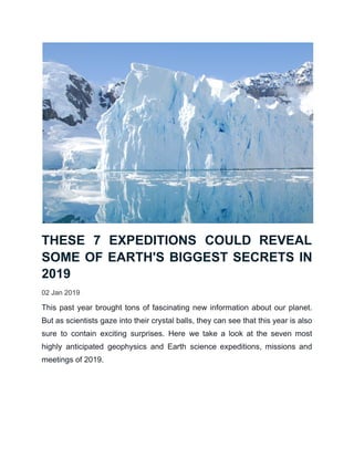
![INSPECTING THWAITES
GLACIER FOR CRACKS
Next summer, a major expedition will head to West Antarctica's Thwaites
Glacier. As part of a $25 million research collaboration between the U.S.
National Science Foundation (NSF) and the United Kingdom's Natural
Environment Research Council (NERC), more than 100 scientists from around
the world will study the giant glacier, which acts something like a cork holding
back other enormous ice masses. Should the glacier begin to collapse, these
masses could slide into the ocean and melt, contributing to sea level rise.
"Satellites show the Thwaites region is changing rapidly," William Easterling,
NSF assistant director for Geosciences, said in a statement. "To answer the
key questions of how much and how quickly sea level will change requires
scientists on the ground with sophisticated equipment collecting the data we
need to measure rates of ice-volume or ice-mass change." [Photos of Melt:
Glaciers Before and After]
CREATING AMAZING NEW ICE
MAPS
In September 2018, NASA launched the Ice, Cloud and Land Elevation
Satellite-2 (ICESat-2), a space-based observatory peering at the poles. The
mission measures the changing thickness of individual patches of ice from
season to season, and can detect increases and decreases as small as a 0.2
inches (0.5 centimeters). Since its launch, the satellite has been collecting a
terabyte of data a day and has already produced one of the most detailed
maps of Antarctica's ice. Some initial results appeared at the annual meeting](data:image/gif;base64,R0lGODlhAQABAIAAAAAAAP///yH5BAEAAAAALAAAAAABAAEAAAIBRAA7)
Recommended
More Related Content
What's hot
What's hot (19)
Similar to These 7 expeditions could reveal some of earth's biggest secrets in 2019
Similar to These 7 expeditions could reveal some of earth's biggest secrets in 2019 (20)
More from HaulTail
More from HaulTail (20)
Recently uploaded
Recently uploaded (20)
These 7 expeditions could reveal some of earth's biggest secrets in 2019
- 1. THESE 7 EXPEDITIONS COULD REVEAL SOME OF EARTH'S BIGGEST SECRETS IN 2019 02 Jan 2019 This past year brought tons of fascinating new information about our planet. But as scientists gaze into their crystal balls, they can see that this year is also sure to contain exciting surprises. Here we take a look at the seven most highly anticipated geophysics and Earth science expeditions, missions and meetings of 2019.
- 2. INSPECTING THWAITES GLACIER FOR CRACKS Next summer, a major expedition will head to West Antarctica's Thwaites Glacier. As part of a $25 million research collaboration between the U.S. National Science Foundation (NSF) and the United Kingdom's Natural Environment Research Council (NERC), more than 100 scientists from around the world will study the giant glacier, which acts something like a cork holding back other enormous ice masses. Should the glacier begin to collapse, these masses could slide into the ocean and melt, contributing to sea level rise. "Satellites show the Thwaites region is changing rapidly," William Easterling, NSF assistant director for Geosciences, said in a statement. "To answer the key questions of how much and how quickly sea level will change requires scientists on the ground with sophisticated equipment collecting the data we need to measure rates of ice-volume or ice-mass change." [Photos of Melt: Glaciers Before and After] CREATING AMAZING NEW ICE MAPS In September 2018, NASA launched the Ice, Cloud and Land Elevation Satellite-2 (ICESat-2), a space-based observatory peering at the poles. The mission measures the changing thickness of individual patches of ice from season to season, and can detect increases and decreases as small as a 0.2 inches (0.5 centimeters). Since its launch, the satellite has been collecting a terabyte of data a day and has already produced one of the most detailed maps of Antarctica's ice. Some initial results appeared at the annual meeting
- 3. of the American Geophysical Union in December 2018 "and the data looks spectacular," physical geographer Michael MacFerrin of the University of Colorado in Boulder, told LiveScience. ICESat-2 will "help revolutionize our real-time views of ice sheets, sea ice and the polar regions in general," he added. "Folks are really excited to work with this dataset once it's out, and I suspect there will be first papers coming out before the end of this year in 2019." DRILLING INTO THE CAUSE OF AN EARTHQUAKE Off the southwest coast of Japan, deep below the Pacific Ocean, sits the Nankai Trough, an active subduction zone where one plate of the Earth's crust is slipping beneath another. It is one of the most seismically active places on the planet, responsible for the 8.1-magnitude Tōnankai earthquake that rocked Japan in 1944. This year, the Nankai Trough Seismogenic Zone Experiment (NanTroSEIZE) began drilling into the fault. It is the "first [expedition] to drill, sample and instrument the earthquake-causing, or seismogenic portion of Earth's crust, where violent, large-scale earthquakes have occurred repeatedly throughout history," according to the mission's website. Rocks collected next year will be analyzed to see how slippery or solid they are, allowing researchers to "understand more about the conditions that might lead to an earthquake on these type of fault," wrote team member John Bedford of the University of Liverpool on the expedition's blog. MEASURING THE FOREST AND THE TREES
- 4. On Dec. 8, NASA launched the Global Ecosystem Dynamics Investigation lidar (GEDI) experiment to the International Space Station. The instrument will be mounted on the outside of the station so it can peer down at our planet and produce incredibly detailed 3D observations of Earth's temperate and tropical forests. GEDI will aim to answer several fundamental questions, including how much carbon is stored in trees and how deforestation could affect climate change, according to the mission's website. This will in turn help researchers model how nutrients cycle through the forest ecosystems and, because forest heights affect wind patterns around the globe, more accurately predict weather, according to the GEDI website. EXPLORING A BURIED ANTARCTIC LAKE As you read these words, scientists in Antarctica are drilling into a subglacial lake buried 4,000 feet (1,200 meters) beneath the West Antarctic Ice Sheet. Known as Lake Mercer, the body of water is completely disconnected from the rest of the world's ecosystems. Researchers are eager to explore the system and learn more about the organisms that are living there, according to the mission's official website. Once the drill reaches the body of water, "equipment will be lowered into the hole to collect samples, take readings, and photograph a subglacial world never before seen by human eyes," according to the site. [Extreme Life on Earth: 8 Bizarre Creatures] LEARNING THE HISTORY OF CORAL REEFS
- 5. Coral reefs are beautiful yet endangered underwater habitats. Pollution and ocean acidification — caused when oceans absorb carbon dioxide released into the atmosphere through the burning of fossil fuels — are threatening reefs all over the globe. Beginning in September of next year, a team of researchers will drill into up to 11 locations beneath the oceans around Hawaii, looking to pull up samples from fossilized coral reef systems. These reefs, which will span 500,000 years of recent geologic history, will help answer critical questions about the amount of carbon dioxide in the atmosphere and Earth's temperature during this period, and how coral reefs reacted to and recovered from large-scale changes, according to the mission's website. The expedition, named the Hawaiian Drowned Reefs expedition, is being run by the European Consortium for Ocean Research Drilling (ECORD), an international body that conducts scientific drilling missions. EXPLORING THE DEEP BIOSPHERE For the last 10 years, scientists with the Deep Carbon Observatory have been digging into Earth to learn more about what's buried beneath our feet. In December, they announced new findings about the "deep biosphere," a subterranean reservoir of uncatalogued organisms that could dwarf the amount of life on our planet's surface. Next October, at an international conference in Washington, D.C., the organization will highlight its last decade of research and look forward to 10 more years of exciting expeditions. Researchers at the meeting will present information on "the nature and extent of carbon in Earth's core, the nature of the whole Earth carbon cycle and how
- 6. has it changed over Earth's history, and the mechanisms that govern microbial evolution and dispersal in the deep biosphere," according to its website.