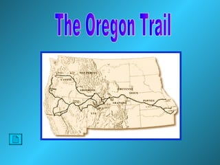
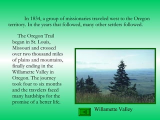
The Oregon Trail
Created by Susan Nelson
In 1834, a group of missionaries traveled west to the Oregon territory. In the years that followed, many other settlers followed. The Oregon Trail began in St. Louis, Missouri and crossed over two thousand miles of plains and mountains, finally ending in the Willamette Valley in Oregon. The journey took four to six months and the travelers faced many hardships for the promise of a better life.  Willamette Valley
How did they get there? In a covered wagon, pulled by oxen!
The Covered Wagon
What did they bring? More
 
A Tour of the Trail The most popular starting point for the trip was St. Louis.  Here families were faced with many decisions. What should we take, what do we need to leave behind? Anything they took had to fit in the wagon.
Fort Kearny Fort Kearny was built to protect the emigrants on the Oregon trail.  It also provided a place for travelers to buy supplies and send mail to friends and family back east. Click to See Ft. Kearny
What was it like on the trail? The land was flat and seemed to stretch forever, until they came to Chimney Rock.
The Trail Continues  From Fort Laramie, the settlers journeyed on past Independence Rock. The south pass is a gap in the Rocky Mountains that stretches for miles. This provided an easier route for the wagon trains to travel.  Click to see  Independence Rock
The Oregon Trail extended through what is now Idaho. It was also in  this area that the trail split and the California trail began. The California trail was started after Gold was discovered in California in 1848.  Many people were lured to California by dreams of striking it rich. The Trail in "Idaho" Legend California Trail Oregon Trail
Those who continued on the Oregon Trail, came to Fort Hall. This fort was originally built as a trading post for the fur traders. Now it was a stopping off point for the pioneers. After leaving Fort Hall, they traveled on through what is now Idaho and were faced with an important decision.  Should they cross the Snake River or take the overland route. Some chose to cross at Three Island Crossing. This was a direct route to Fort Boise and saved some time, but the crossing was difficult and dangerous.  Replica of Fort Hall
Oregon at Last ! Even though the journey was almost over, Barlow Road a treacherous stretch still lay ahead.   This toll road was built as an alternative to navigating the Columbia River. Sarah Cummins (A traveler on the trail):  "The traveling was slow and toilsome; slopes were almost impassible for man and beast. As night was coming on, it seemed we all must perish, but weak, faint and starving we went on. I could scarcely put one foot before the another. I weighed less than eighty pounds at the time. My own party had been 14 days with only nine biscuits and four   small slices of bacon. "  
After the Barlow Road, Oregon City was the next and final destination on the Oregon Trail.  Here the settlers could visit the only land office west of the Rocky Mountains to file their claim. The land was rich and fertile, a welcoming place to settle.
There were many other trails and routes that settlers took to reach the west.  The Oregon Trail was one of the most used routes.  In the 1860’s, people stopped using the trail, can you guess why? Answer Next
The transcontinental railway was completed. Return to question
Clip Art http://www.endoftheoregontrail.org/wagons.html  diagram http://www.pbs.org/opb/oregontrail/teacher/trailmap.html http://www3.memlane.com/gromboug/P14MvCon.htm  western clip art http://www.isu.edu/~trinmich/Stlouis.html  St. Louis http://dir.nvtech.com/History/United_States/Old_West/Characters/Prospectors/ Back Works Cited
Photographs   http://www. ruralheritage .com/drew/ oregon . jpg  wagon and oxen http://www. rpi . edu /~ mccafr /oregon2. jpg  williamette valley http://www. nebraskahistory .org/sites/rock/  chimney rock http://www. isu . edu /~ trinmich / qtvrkearny .html http://www.poky.net/ forthall /index. shtml  Fort Hall Replica http://www.isu.edu/~trinmich/Oregoncity.html Works Cited
Clip Art http://www.emigrantroad.com/images/trail2.jpg  nebraska map http://www.nctc.net/counties/nebrmaps/oregon_trail_markers.jpg  nebraska trail http://calcite.rocky.edu/octa/trailmap.htm  trail map http://www.idahoparks.org/parks/threeisland.html http://www.emigrantroad.com/images/trail2.jpg Animated wagon http://www.endoftheoregontrail.org/maplibrary/wyoming.html http://www.isu.edu/~trinmich/00.map.or.html  Oregon Map Works Cited
Text http://www.10960.com/ webquest / gowest . htm  web quest  http://www. endoftheoregontrail .org/ faq .html  FAQ h ttp ://www. endoftheoregontrail .org/ biomenu .html# PioFam   Biographies http://www. isu . edu /~ trinmich / Allabout .html http://xroads.virginia.edu/~HYPER/OREGON/oregon.html http://www.isu.edu/~trinmich/Oregontrail.html   Sound Files American Dreamer:Songs of Stephen Foster, Thomas Hampton The Magnificent Seven, Elmer Bernstein Works Cited

The Oregon Trail

  • 1.
  • 2.
  • 3.
    In 1834, agroup of missionaries traveled west to the Oregon territory. In the years that followed, many other settlers followed. The Oregon Trail began in St. Louis, Missouri and crossed over two thousand miles of plains and mountains, finally ending in the Willamette Valley in Oregon. The journey took four to six months and the travelers faced many hardships for the promise of a better life. Willamette Valley
  • 4.
    How did theyget there? In a covered wagon, pulled by oxen!
  • 5.
  • 6.
    What did theybring? More
  • 7.
  • 8.
    A Tour ofthe Trail The most popular starting point for the trip was St. Louis. Here families were faced with many decisions. What should we take, what do we need to leave behind? Anything they took had to fit in the wagon.
  • 9.
    Fort Kearny FortKearny was built to protect the emigrants on the Oregon trail. It also provided a place for travelers to buy supplies and send mail to friends and family back east. Click to See Ft. Kearny
  • 10.
    What was itlike on the trail? The land was flat and seemed to stretch forever, until they came to Chimney Rock.
  • 11.
    The Trail Continues From Fort Laramie, the settlers journeyed on past Independence Rock. The south pass is a gap in the Rocky Mountains that stretches for miles. This provided an easier route for the wagon trains to travel. Click to see Independence Rock
  • 12.
    The Oregon Trailextended through what is now Idaho. It was also in this area that the trail split and the California trail began. The California trail was started after Gold was discovered in California in 1848. Many people were lured to California by dreams of striking it rich. The Trail in "Idaho" Legend California Trail Oregon Trail
  • 13.
    Those who continuedon the Oregon Trail, came to Fort Hall. This fort was originally built as a trading post for the fur traders. Now it was a stopping off point for the pioneers. After leaving Fort Hall, they traveled on through what is now Idaho and were faced with an important decision. Should they cross the Snake River or take the overland route. Some chose to cross at Three Island Crossing. This was a direct route to Fort Boise and saved some time, but the crossing was difficult and dangerous. Replica of Fort Hall
  • 14.
    Oregon at Last! Even though the journey was almost over, Barlow Road a treacherous stretch still lay ahead. This toll road was built as an alternative to navigating the Columbia River. Sarah Cummins (A traveler on the trail): "The traveling was slow and toilsome; slopes were almost impassible for man and beast. As night was coming on, it seemed we all must perish, but weak, faint and starving we went on. I could scarcely put one foot before the another. I weighed less than eighty pounds at the time. My own party had been 14 days with only nine biscuits and four small slices of bacon. "  
  • 15.
    After the BarlowRoad, Oregon City was the next and final destination on the Oregon Trail. Here the settlers could visit the only land office west of the Rocky Mountains to file their claim. The land was rich and fertile, a welcoming place to settle.
  • 16.
    There were manyother trails and routes that settlers took to reach the west. The Oregon Trail was one of the most used routes. In the 1860’s, people stopped using the trail, can you guess why? Answer Next
  • 17.
    The transcontinental railwaywas completed. Return to question
  • 18.
    Clip Art http://www.endoftheoregontrail.org/wagons.html diagram http://www.pbs.org/opb/oregontrail/teacher/trailmap.html http://www3.memlane.com/gromboug/P14MvCon.htm western clip art http://www.isu.edu/~trinmich/Stlouis.html St. Louis http://dir.nvtech.com/History/United_States/Old_West/Characters/Prospectors/ Back Works Cited
  • 19.
    Photographs http://www. ruralheritage .com/drew/ oregon . jpg wagon and oxen http://www. rpi . edu /~ mccafr /oregon2. jpg williamette valley http://www. nebraskahistory .org/sites/rock/ chimney rock http://www. isu . edu /~ trinmich / qtvrkearny .html http://www.poky.net/ forthall /index. shtml Fort Hall Replica http://www.isu.edu/~trinmich/Oregoncity.html Works Cited
  • 20.
    Clip Art http://www.emigrantroad.com/images/trail2.jpg nebraska map http://www.nctc.net/counties/nebrmaps/oregon_trail_markers.jpg nebraska trail http://calcite.rocky.edu/octa/trailmap.htm trail map http://www.idahoparks.org/parks/threeisland.html http://www.emigrantroad.com/images/trail2.jpg Animated wagon http://www.endoftheoregontrail.org/maplibrary/wyoming.html http://www.isu.edu/~trinmich/00.map.or.html Oregon Map Works Cited
  • 21.
    Text http://www.10960.com/ webquest/ gowest . htm web quest http://www. endoftheoregontrail .org/ faq .html FAQ h ttp ://www. endoftheoregontrail .org/ biomenu .html# PioFam Biographies http://www. isu . edu /~ trinmich / Allabout .html http://xroads.virginia.edu/~HYPER/OREGON/oregon.html http://www.isu.edu/~trinmich/Oregontrail.html Sound Files American Dreamer:Songs of Stephen Foster, Thomas Hampton The Magnificent Seven, Elmer Bernstein Works Cited