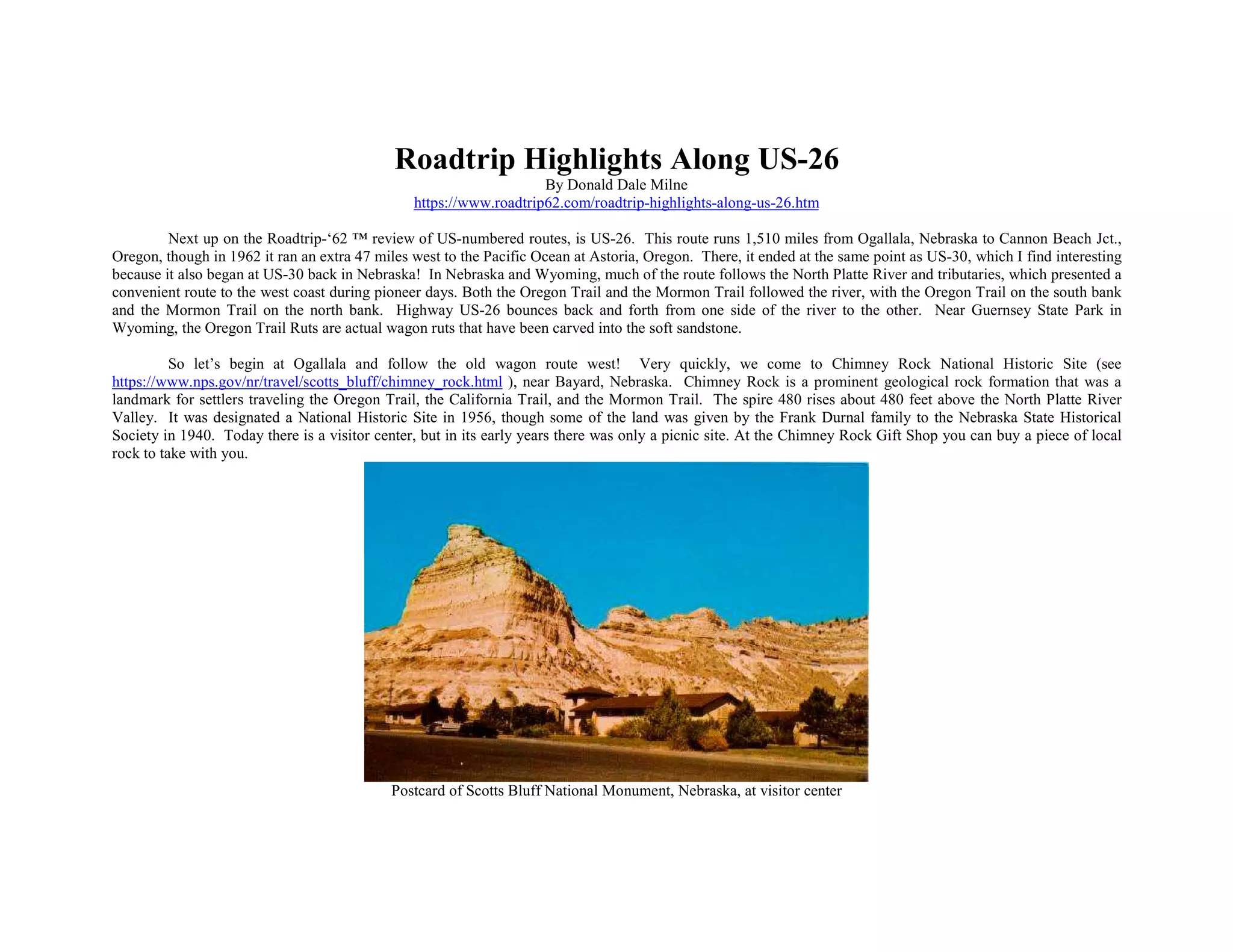
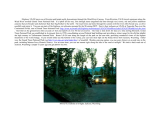
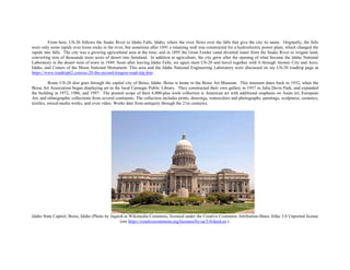
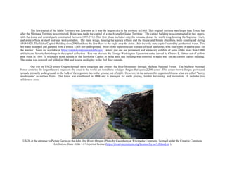
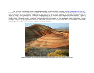
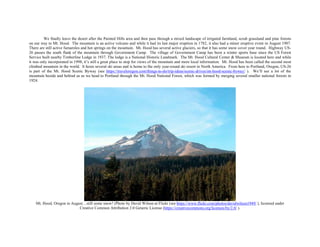
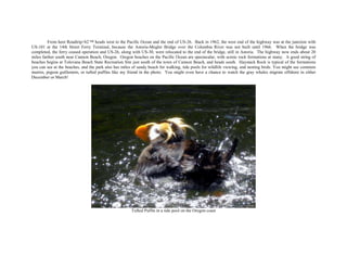
Roadtrip Highlights Along US-26
By Donald Dale Milne
https://www.roadtrip62.com/roadtrip-highlights-along-us-26.htm
Next up on the Roadtrip-‘62 ™ review of US-numbered routes, is US-26. This route runs 1,510 miles from Ogallala, Nebraska to Cannon Beach Jct.,
Oregon, though in 1962 it ran an extra 47 miles west to the Pacific Ocean at Astoria, Oregon. There, it ended at the same point as US-30, which I find interesting
because it also began at US-30 back in Nebraska! In Nebraska and Wyoming, much of the route follows the North Platte River and tributaries, which presented a
convenient route to the west coast during pioneer days. Both the Oregon Trail and the Mormon Trail followed the river, with the Oregon Trail on the south bank
and the Mormon Trail on the north bank. Highway US-26 bounces back and forth from one side of the river to the other. Near Guernsey State Park in
Wyoming, the Oregon Trail Ruts are actual wagon ruts that have been carved into the soft sandstone.
So let’s begin at Ogallala and follow the old wagon route west! Very quickly, we come to Chimney Rock National Historic Site (see
https://www.nps.gov/nr/travel/scotts_bluff/chimney_rock.html ), near Bayard, Nebraska. Chimney Rock is a prominent geological rock formation that was a
landmark for settlers traveling the Oregon Trail, the California Trail, and the Mormon Trail. The spire 480 rises about 480 feet above the North Platte River
Valley. It was designated a National Historic Site in 1956, though some of the land was given by the Frank Durnal family to the Nebraska State Historical
Society in 1940. Today there is a visitor center, but in its early years there was only a picnic site. At the Chimney Rock Gift Shop you can buy a piece of local
rock to take with you.
Postcard of Scotts Bluff National Monument, Nebraska, at visitor center
About 18 miles west, in Scottsbluff, Nebraska, is another prominent rock formation, Scotts Bluff National Monument (see
https://www.nps.gov/scbl/index.htm ). This site was designated a National Monument in 1919 and protects over 3,000 acres of historic overland trail remnants
and the bluffs, along with some mixed-grass prairie, badlands, and area along the North Platte River. The visitor center at the base of the bluff serves as a
starting point for hiking tours of the bluffs. There is also a roadway leading to the top of the 800-foot high Scotts Bluff, which was constructed by the Civilian
Conservation Corps in the 1930s. The road goes through three tunnels on its way to the top and provides easy access to the summit, where there is another
trailhead. As Nebraska is generally only a rolling landscape, these are the only three vehicular tunnels in the state. Also within the monument is the
reconstructed Rodidoux Trading Post, a reproduction of the trading post that was located here in the early 1850s. You can see an exhibit of the furs, traps, beads,
and cookware that was sold from the trading post. Wagon trails and several markers show the original path of the trail within the park.
Another important site along the famous westward trails is Fort Laramie National Historic Site (see https://www.nps.gov/fola/index.htm ), near the town
of the same name. Originally established as a private fur trading fort in 1834 known as Fort William, the fort evolved into the largest post on the Northern Plains
before its abandonment in 1890. It was located at an advantageous spot at confluence of the Laramie and North Platte Rivers, just east of the long climb to the
best and lowest crossing point of the Rocky Mountains at South Pass, Wyoming. The post originally did good business trading commercial goods for beaver
pelts and buffalo hides, but by the 1840s it began doing a seasonal business catering to the needs of emigrants heading west to Utah and the west coast. By 1849
these travelers were estimated to number between 20,000 and 40,000. The fort was sold several times, and that year, the U.S. Army purchased the fort as part of a
plan to establish a military presence along the emigrant trails and renamed it Fort Laramie. It next became the primary hub for transportation and communication
through the central Rocky Mountain region. Emigrant trails, stagecoach lines, the Pony Express, and even the transcontinental telegraph all passed through the
post. After 1869, when the first transcontinental railroad was completed through Utah, wagon traffic past the fort began decreasing. As the Indian Wars
eventually ended, Fort Laramie's importance diminished, so it was abandoned and sold piecemeal at public auction in 1890.
Over the next 48 years, the buildings deteriorated but future preservation of the site was secured in 1938 when Fort Laramie became part of the National
Park System. Today, you can see the visitor center located in the restored 1884 Commissary Storehouse, tour a museum, and explore the grounds including some
remaining ruins. Many buildings have been restored to the period from 1849 to the late 1880s. During summer months, staff members and volunteers appear in
period dress to bring history alive on the grounds. There is also a hiking trail that leads to the confluence of the Platte and Laramie Rivers. A video tour of the
fort is at https://www.youtube.com/embed/1dqeeglMHLg .
Wagon tracks of the Oregon Trail in Guernsey, Wyoming (Photo by Paul Hermans from Wikimedia Commons, licensed under Creative Commons Attribution-
Share Alike 3.0 Unported license (see https://creativecommons.org/licenses/by-sa/3.0/deed.en ).
Highway US-26 continues to follow the North Platte River through an agricultural area to the industrial city of Casper, Wyoming. There are several
other Oregon Trail historical sites along this portion of the road, including museums in Douglas and Glenrock, Wyoming. At Guernsey, Wyoming are Oregon
Trail Ruts and Register Cliff. The cliffs in Guernsey State Park have inscriptions of the names of the people making the journey; a museum offers information on
the trail. Wagon ruts carved into the sandstone on The Oregon Trail can still be seen just 1/2 mile south of Guernsey while the ruts are actual wagon ruts that
have carved into the soft sandstone. From 1841-1869, the constant travel of people, their wagons, and their animals wore the trail from two to six feet down into
a sandstone ridge here, creating the best-preserved set of Oregon Trail ruts anywhere along its former length. Register Cliff is only two miles southeast of town
and was used by pioneers to carve their names into the soft sandstone as a record for those who followed. The landmark still remains much the way it looked to
pioneers on the wagon trains heading west. Further down the road, we meet US-20 at Orin, Wyoming and travel with it for 162 miles to Shoshoni, Wyoming, as
highlighted on our US-20 roadtrip at https://www.roadtrip62.com/us-20-the-second-longest-road-trip.htm .
Casper is an industrial town that grew with the oil industry. It’s nicknamed "The Oil City" and first bloomed during an oil boom on the nearby Salt
Creek Oil Field in 1889. As recently as the early 1980s, the city and nearby area was home to three refineries, though only one remains. Today, Casper holds 11
museums but most were founded after 1962, so we won’t be stopping. If you stop, you will find something for every taste, including an art museum, the Tate
Geological Museum, a planetarium, science museum, veterans museum, and some history museums. From here, the trip through mid-Wyoming crosses cattle
rangeland and badlands on the way to Riverton. You may see livestock alongside the highway and if you look closely, you will notice cattle guards at the
crossroads along the way. These are intended to reduce hazards by keeping the cows off the main highway. Riverton had its major growth spurt in the 1950s as
uranium mining in the surrounding Gas Hills boomed. However, the closure of those mines resulted in a downturn in the area. In addition to livestock ranching
and some retained uranium activity, there is also oil and gas production in the area.
Postcard of Red Rock along the Wind River and US-26, Wyoming
Highway US-20 leaves us at Riverton and heads north, downstream through the Wind River Canyon. From Riverton, US-26 travels upstream along the
Wind River towards Grand Teton National Park. It’s uphill all the way, first through more rangeland and later through very scenic, red and yellow sandstone
canyons that are broader and shallower than their big brother to the north. The road twists and turns through the scenery with the river often beside you, so drive
carefully and enjoy it. You can see parts of the highway on webcams operated by the Wyoming DOT. Here’s their webcam on US-26 at Togwotte Pass over the
Continental Divide, east of Grand Teton National Park: http://www.wyoroad.info/highway/webcameras/US26287WindRiverLake/US26287WindRiverLake.html
. Snowfall on the ground here often exceeds 25 feet and reports of over 50 feet are known. The road is shut down for days at a time during blizzards. Grand
Teton National Park was established in its present form in 1950, consolidating several Federal land holdings and providing a winter range for the elk that inhabit
the high country in Yellowstone National Park. Route US-26 runs along the length of the park on the east side, providing wonderful views of the highest
mountains of the Teton Range. If you would rather see the bottom of the valley, you can take float trips on the Snake River from Jackson, Wyoming. Either
way, the Grand Teton National Park (see http://www.nps.gov/grte/index.htm ) is beautiful. Besides enjoying nature, you can enjoy history at several sites in the
park, including Menors Ferry Historic District. For an extra treat, you can see moose right along the side of the road at twilight! We took a back road out of
Jackson, Wyoming a couple of years ago and got photos like this.
Moose by roadside at twilight, Jackson, Wyoming
From here, US-26 follows the Snake River to Idaho Falls, Idaho, where the river flows over the falls that give the city its name. Originally, the falls
were only some rapids over loose rocks in the river, but sometime after 1891 a retaining wall was constructed for a hydroelectric power plant, which changed the
rapids into falls. The city was a growing agricultural area at the time, and in 1895 the Great Feeder canal diverted water from the Snake River to irrigate land,
converting tens of thousands more acres of desert into farmland. In addition to agriculture, the city grew after the opening of what became the Idaho National
Laboratory in the desert west of town in 1949. Soon after leaving Idaho Falls, we again meet US-20 and travel together with it through Atomic City and Arco,
Idaho, and Craters of the Moon National Monument. This area and the Idaho National Engineering Laboratory were discussed on my US-20 roadtrip page at
https://www.roadtrip62.com/us-20-the-second-longest-road-trip.htm .
Route US-26 also goes through the capital city of Boise, Idaho. Boise is home to the Boise Art Museum. This museum dates back to 1932, when the
Boise Art Association began displaying art in the local Carnegie Public Library. They constructed their own gallery in 1937 in Julia Davis Park, and expanded
the building in 1972, 1986, and 1997. The present scope of their 4,000-plus work collection is American art with additional emphasis on Asian art, European
Art, and ethnographic collections from several continents. The collection includes prints, drawings, watercolors and photographs, paintings, sculptures, ceramics,
textiles, mixed-media works, and even video. Works date from antiquity through the 21st centuries.
Idaho State Capitol, Boise, Idaho (Photo by Jsquish at Wikimedia Commons, licensed under the Creative Commons Attribution-Share Alike 3.0 Unported license
(see https://creativecommons.org/licenses/by-sa/3.0/deed.en ).
The first capital of the Idaho Territory was Lewiston as it was the largest city in the territory in 1863. This original territory was larger than Texas, but
after the Montana Territory was removed, Boise was made the capital of a much smaller Idaho Territory. The capitol building was constructed in two stages,
with the dome and central parts constructed between 1905-1912. This first phase included only the rotunda, dome, the north wing housing the Supreme Court,
and some offices in short east and west corridors. The main wings, housing the agency offices and the House and Senate chambers, were constructed during
1919-1920. The Idaho Capitol Building rises 208 feet from the first floor to the eagle atop the dome. It is the only state capitol heated by geothermal water. This
hot water is tapped and pumped from a source 3,000 feet underground. Most of the superstructure is made of local sandstone, with four types of marble used for
the interior. Tours are available at https://capitolcommission.idaho.gov/ , where you can see permanent and temporary exhibits of some of the more than 1,000
artifacts and historic furnishings in the capitol collection. You can also see the George Washington Equestrian statue carved by Charles L. Ostner out of yellow
pine wood in 1869. It originally stood outside of the Territorial Capitol in Boise until that building was removed to make way for the current capitol building.
The statue was restored and gilded in 1966 and is now on display in the 2nd floor rotunda.
Our trip on US-26 enters Oregon through more rangeland and crosses the Blue Mountains through Malheur National Forest. The Malheur National
Forest contains the largest known organism (by area) in the world: an Armillaria solidipes fungus that spans 2,200 acres! This cream-brown fungus grows and
spreads primarily underground, so the bulk of the organism lies in the ground, out of sight. However, in the autumn this organism blooms what are called "honey
mushrooms" as surface fruits. The forest was established in 1908 and is managed for cattle grazing, lumber harvesting, and recreation. It includes two
wilderness areas.
US-26 at the entrance to Picture Gorge on the John Day River, Oregon (Photo by Cacophony at Wikimedia Commons, licensed under the Creative Commons
Attribution-Share Alike 3.0 Unported license (https://creativecommons.org/licenses/by-sa/3.0/deed.en ).
After we descend from the forest, we enter a desert and make a stop at the John Day National Fossil Beds (see https://www.nps.gov/joda/index.htm ).
People have been studying the fossils in the region since 1864. The National Monument was not declared until 1975, though Oregon purchased the land in the
1930s for state parks. In 1962, we would have visited the sites at Sheep Rock and the Painted Hills as state parks. The Sheep Rock Unit is just off US-26 and
includes the Thomas Condon Paleontology and Visitor Center, which is a working lab, and hiking trails. Fossils of plants and animals are found in a number of
geological layers dating from 33-7 million years ago in this area. The Painted Hills Unit is located farther west along US-26 and about 9 miles northwest of
Mitchell, Oregon. These scenic hills show varied stripes of red, tan, orange, and black sediments and preserve a sequence of past climate change. There are
more hiking trails in this area. Remember, this is a real desert, so if you hike, take plenty of water and some portable shade. As a bonus, US-26 runs through the
Picture Gorge on the John Day River between these two parts of the National Monument.
Painted Hills at John Day National Fossil Beds, Oregon (Public domain photo from National Park Service.)
We finally leave the desert after the Painted Hills area and then pass through a mixed landscape of irrigated farmland, scrub grassland and pine forests
on our way to Mt. Hood. The mountain is an active volcano and while it had its last major eruption in 1782, it also had a minor eruptive event in August 1907.
There are still active fumaroles and hot springs on the mountain. Mt. Hood has several active glaciers, so that it has some snow cover year round. Highway US-
26 passes the south flank of the mountain through Government Camp. The village of Government Camp has been a winter sports base since the US Forest
Service built nearby Timberline Lodge in 1937. The lodge is a National Historic Landmark. The Mt. Hood Cultural Center & Museum is located here and while
it was only incorporated in 1998, it’s still a great place to stop for views of the mountain and more local information. Mt. Hood has been called the second most
climbed mountain in the world. It hosts several ski areas and is home to the only year-round ski resort in North America. From here to Portland, Oregon, US-26
is part of the Mt. Hood Scenic Byway (see https://traveloregon.com/things-to-do/trip-ideas/scenic-drives/mt-hood-scenic-byway/ ). We’ll see a lot of the
mountain beside and behind us as we head to Portland through the Mt. Hood National Forest, which was formed by merging several smaller national forests in
1924.
Mt. Hood, Oregon in August…still some snow! (Photo by David Wilson at Flickr (see https://www.flickr.com/photos/davidwilson1949/ ), licensed under
Creative Common Attribution 2.0 Generic License (https://creativecommons.org/licenses/by/2.0/ ).
Portland prides itself on public art and has dozens of public fountains of every different style, constructed during many different eras. Most are in or
near the downtown and the city offers a walking tour map at https://www.portlandoregon.gov/parks/article/521803 . Some we could have seen in 1962 are Elk
Fountain, with its elk statue; Skidmore Fountain, Portland’s oldest commissioned public art; and Shemanski Fountain, also known as Rebecca at the Well.
Portland is known as "The City of Roses" and I always enjoy a visit to the International Rose Test Garden in Washington Park when I travel through the city.
Washington Park is right on US-26, so it’s easy to find. The garden is the oldest official continuously operated public rose test garden in the United States,
featuring more than 10,000 roses. The garden was conceived by Jesse A. Currey in 1915 and approved by Portland Parks in 1917. It’s open daily and admission
is free to view its over 650 varieties of roses. Roses do very well here due to the weather, and bloom from April through October. And if you want to enjoy
some other flowers, try the Crystal Springs Rhododendron Garden. Crystal Springs was founded in 1950 as a rhododendron test garden and now contains more
than 2,500 rhododendrons and azaleas.
International Rose Test Garden, Portland, Oregon
From here Roadtrip-'62 ™ heads west to the Pacific Ocean and the end of US-26. Back in 1962, the west end of the highway was at the junction with
US-101 at the 14th Street Ferry Terminal, because the Astoria-Megler Bridge over the Columbia River was not built until 1966. When the bridge was
completed, the ferry ceased operation and US-26, along with US-30, were relocated to the end of the bridge, still in Astoria. The highway now ends about 20
miles farther south near Cannon Beach, Oregon. Oregon beaches on the Pacific Ocean are spectacular, with scenic rock formations at many. A good string of
beaches begins at Tolovana Beach State Recreation Site just south of the town of Cannon Beach, and heads south. Haystack Rock is typical of the formations
you can see at the beaches, and the park also has miles of sandy beach for walking, tide pools for wildlife viewing, and nesting birds. You might see common
murres, pigeon guillemots, or tufted puffins like my friend in the photo. You might even have a chance to watch the gray whales migrate offshore in either
December or March!
Tufted Puffin in a tide pool on the Oregon coast
Visit ROADTRIP-'62 ™ ( https://www.roadtrip62.com/index.htm ) for more articles.
Or visit us on Facebook https://www.facebook.com/pages/Roadtrip62/119235794845685 ,
Pinterest https://www.pinterest.com/roadtrip62/ ,
or Flickr https://www.flickr.com/photos/67972937@N07/page1 .
Author of Roadtrip-'62™ ( https://www.roadtrip62.com/ ), Donald Dale Milne
If you haven’t heard of nor Roadtrip-'62 ™ , my name is Don Milne and I'll be your travel guide on this virtual tour of the U. S. of A. First, I suppose
you're wondering why nor Roadtrip-'62 ™ is different from other travel sites? There's a very simple answer: everybody else travels only in space, but we also
travel in time! That's right, we don't just go somewhere, we also go somewhen. And the when is 1962. We'll try to see what's left today from 1962, by driving as
if it were 1962. We will drive on highways as they were in 1962, try to eat only at restaurants that existed in 1962, try to stay only at motels that existed in 1962,
try to buy gas and sundries, play the music, see only the sites across America, and just generally live in America as it was in 1962!
What we will do is enjoy the FUN of cross-country driving. And the fun of cross-country travel is all the differences from our everyday life! We'll talk
about politics, food, great inventions, how people lived, television, and more. We'll get to see some of the people that made our history; that made this country
great. We'll stumble across unexpected pleasures, like one trip I made through Cherokee, North Carolina where I just happened to be in town as the 1996
Olympic Torch procession came through on it's way to Atlanta, Georgia. You really never know what you'll find when you travel!
1962-style US-23 signs
Now, let's see where we'll be going! We're going to drive the US-numbered routes of 1962. Because we'll be using the roads of 1962, that means we
won't be on freeways very much. There weren't many freeways in 1962, as the country had just begun building the Interstate system,, so we'll travel mostly the
two-lanes through every little town on the way. Sometimes even where there was a freeway, I'll go back on the old road just to see what was there. Anyway, even
if there was a freeway in 1962, it was only there for a couple of years and things had not changed much. Sometimes a "business route" ran through a town on the
old route, because there were no services at the freeway interchanges yet.
Just in case you're asking why 1962, it's because I remember 1962. I traveled on my first freeway as a boy with my dad about that time, and fell in love
with both travel and freeways. But, besides my own memories and the fact that it was a time largely before interstate freeways, 1962 is just cool...wait and see!
And I'm writing this virtual tour just because I like to drive. I like to go places, see things, and just drive for the joy of driving! I decided I want to talk about it, to
share the fun with others. I'll be doing the driving on our Roadtrip-'62 ™, but if you see anything you like, I encourage you to get out on the road and enjoy it in
person. This virtual roadtrip may be fun, but there's nothing like the real thing!

Roadtrip Highlights along US-26

  • 1.
    Roadtrip Highlights AlongUS-26 By Donald Dale Milne https://www.roadtrip62.com/roadtrip-highlights-along-us-26.htm Next up on the Roadtrip-‘62 ™ review of US-numbered routes, is US-26. This route runs 1,510 miles from Ogallala, Nebraska to Cannon Beach Jct., Oregon, though in 1962 it ran an extra 47 miles west to the Pacific Ocean at Astoria, Oregon. There, it ended at the same point as US-30, which I find interesting because it also began at US-30 back in Nebraska! In Nebraska and Wyoming, much of the route follows the North Platte River and tributaries, which presented a convenient route to the west coast during pioneer days. Both the Oregon Trail and the Mormon Trail followed the river, with the Oregon Trail on the south bank and the Mormon Trail on the north bank. Highway US-26 bounces back and forth from one side of the river to the other. Near Guernsey State Park in Wyoming, the Oregon Trail Ruts are actual wagon ruts that have been carved into the soft sandstone. So let’s begin at Ogallala and follow the old wagon route west! Very quickly, we come to Chimney Rock National Historic Site (see https://www.nps.gov/nr/travel/scotts_bluff/chimney_rock.html ), near Bayard, Nebraska. Chimney Rock is a prominent geological rock formation that was a landmark for settlers traveling the Oregon Trail, the California Trail, and the Mormon Trail. The spire 480 rises about 480 feet above the North Platte River Valley. It was designated a National Historic Site in 1956, though some of the land was given by the Frank Durnal family to the Nebraska State Historical Society in 1940. Today there is a visitor center, but in its early years there was only a picnic site. At the Chimney Rock Gift Shop you can buy a piece of local rock to take with you. Postcard of Scotts Bluff National Monument, Nebraska, at visitor center
  • 2.
    About 18 mileswest, in Scottsbluff, Nebraska, is another prominent rock formation, Scotts Bluff National Monument (see https://www.nps.gov/scbl/index.htm ). This site was designated a National Monument in 1919 and protects over 3,000 acres of historic overland trail remnants and the bluffs, along with some mixed-grass prairie, badlands, and area along the North Platte River. The visitor center at the base of the bluff serves as a starting point for hiking tours of the bluffs. There is also a roadway leading to the top of the 800-foot high Scotts Bluff, which was constructed by the Civilian Conservation Corps in the 1930s. The road goes through three tunnels on its way to the top and provides easy access to the summit, where there is another trailhead. As Nebraska is generally only a rolling landscape, these are the only three vehicular tunnels in the state. Also within the monument is the reconstructed Rodidoux Trading Post, a reproduction of the trading post that was located here in the early 1850s. You can see an exhibit of the furs, traps, beads, and cookware that was sold from the trading post. Wagon trails and several markers show the original path of the trail within the park. Another important site along the famous westward trails is Fort Laramie National Historic Site (see https://www.nps.gov/fola/index.htm ), near the town of the same name. Originally established as a private fur trading fort in 1834 known as Fort William, the fort evolved into the largest post on the Northern Plains before its abandonment in 1890. It was located at an advantageous spot at confluence of the Laramie and North Platte Rivers, just east of the long climb to the best and lowest crossing point of the Rocky Mountains at South Pass, Wyoming. The post originally did good business trading commercial goods for beaver pelts and buffalo hides, but by the 1840s it began doing a seasonal business catering to the needs of emigrants heading west to Utah and the west coast. By 1849 these travelers were estimated to number between 20,000 and 40,000. The fort was sold several times, and that year, the U.S. Army purchased the fort as part of a plan to establish a military presence along the emigrant trails and renamed it Fort Laramie. It next became the primary hub for transportation and communication through the central Rocky Mountain region. Emigrant trails, stagecoach lines, the Pony Express, and even the transcontinental telegraph all passed through the post. After 1869, when the first transcontinental railroad was completed through Utah, wagon traffic past the fort began decreasing. As the Indian Wars eventually ended, Fort Laramie's importance diminished, so it was abandoned and sold piecemeal at public auction in 1890. Over the next 48 years, the buildings deteriorated but future preservation of the site was secured in 1938 when Fort Laramie became part of the National Park System. Today, you can see the visitor center located in the restored 1884 Commissary Storehouse, tour a museum, and explore the grounds including some remaining ruins. Many buildings have been restored to the period from 1849 to the late 1880s. During summer months, staff members and volunteers appear in period dress to bring history alive on the grounds. There is also a hiking trail that leads to the confluence of the Platte and Laramie Rivers. A video tour of the fort is at https://www.youtube.com/embed/1dqeeglMHLg .
  • 3.
    Wagon tracks ofthe Oregon Trail in Guernsey, Wyoming (Photo by Paul Hermans from Wikimedia Commons, licensed under Creative Commons Attribution- Share Alike 3.0 Unported license (see https://creativecommons.org/licenses/by-sa/3.0/deed.en ). Highway US-26 continues to follow the North Platte River through an agricultural area to the industrial city of Casper, Wyoming. There are several other Oregon Trail historical sites along this portion of the road, including museums in Douglas and Glenrock, Wyoming. At Guernsey, Wyoming are Oregon Trail Ruts and Register Cliff. The cliffs in Guernsey State Park have inscriptions of the names of the people making the journey; a museum offers information on the trail. Wagon ruts carved into the sandstone on The Oregon Trail can still be seen just 1/2 mile south of Guernsey while the ruts are actual wagon ruts that have carved into the soft sandstone. From 1841-1869, the constant travel of people, their wagons, and their animals wore the trail from two to six feet down into a sandstone ridge here, creating the best-preserved set of Oregon Trail ruts anywhere along its former length. Register Cliff is only two miles southeast of town and was used by pioneers to carve their names into the soft sandstone as a record for those who followed. The landmark still remains much the way it looked to pioneers on the wagon trains heading west. Further down the road, we meet US-20 at Orin, Wyoming and travel with it for 162 miles to Shoshoni, Wyoming, as highlighted on our US-20 roadtrip at https://www.roadtrip62.com/us-20-the-second-longest-road-trip.htm .
  • 4.
    Casper is anindustrial town that grew with the oil industry. It’s nicknamed "The Oil City" and first bloomed during an oil boom on the nearby Salt Creek Oil Field in 1889. As recently as the early 1980s, the city and nearby area was home to three refineries, though only one remains. Today, Casper holds 11 museums but most were founded after 1962, so we won’t be stopping. If you stop, you will find something for every taste, including an art museum, the Tate Geological Museum, a planetarium, science museum, veterans museum, and some history museums. From here, the trip through mid-Wyoming crosses cattle rangeland and badlands on the way to Riverton. You may see livestock alongside the highway and if you look closely, you will notice cattle guards at the crossroads along the way. These are intended to reduce hazards by keeping the cows off the main highway. Riverton had its major growth spurt in the 1950s as uranium mining in the surrounding Gas Hills boomed. However, the closure of those mines resulted in a downturn in the area. In addition to livestock ranching and some retained uranium activity, there is also oil and gas production in the area. Postcard of Red Rock along the Wind River and US-26, Wyoming
  • 5.
    Highway US-20 leavesus at Riverton and heads north, downstream through the Wind River Canyon. From Riverton, US-26 travels upstream along the Wind River towards Grand Teton National Park. It’s uphill all the way, first through more rangeland and later through very scenic, red and yellow sandstone canyons that are broader and shallower than their big brother to the north. The road twists and turns through the scenery with the river often beside you, so drive carefully and enjoy it. You can see parts of the highway on webcams operated by the Wyoming DOT. Here’s their webcam on US-26 at Togwotte Pass over the Continental Divide, east of Grand Teton National Park: http://www.wyoroad.info/highway/webcameras/US26287WindRiverLake/US26287WindRiverLake.html . Snowfall on the ground here often exceeds 25 feet and reports of over 50 feet are known. The road is shut down for days at a time during blizzards. Grand Teton National Park was established in its present form in 1950, consolidating several Federal land holdings and providing a winter range for the elk that inhabit the high country in Yellowstone National Park. Route US-26 runs along the length of the park on the east side, providing wonderful views of the highest mountains of the Teton Range. If you would rather see the bottom of the valley, you can take float trips on the Snake River from Jackson, Wyoming. Either way, the Grand Teton National Park (see http://www.nps.gov/grte/index.htm ) is beautiful. Besides enjoying nature, you can enjoy history at several sites in the park, including Menors Ferry Historic District. For an extra treat, you can see moose right along the side of the road at twilight! We took a back road out of Jackson, Wyoming a couple of years ago and got photos like this. Moose by roadside at twilight, Jackson, Wyoming
  • 6.
    From here, US-26follows the Snake River to Idaho Falls, Idaho, where the river flows over the falls that give the city its name. Originally, the falls were only some rapids over loose rocks in the river, but sometime after 1891 a retaining wall was constructed for a hydroelectric power plant, which changed the rapids into falls. The city was a growing agricultural area at the time, and in 1895 the Great Feeder canal diverted water from the Snake River to irrigate land, converting tens of thousands more acres of desert into farmland. In addition to agriculture, the city grew after the opening of what became the Idaho National Laboratory in the desert west of town in 1949. Soon after leaving Idaho Falls, we again meet US-20 and travel together with it through Atomic City and Arco, Idaho, and Craters of the Moon National Monument. This area and the Idaho National Engineering Laboratory were discussed on my US-20 roadtrip page at https://www.roadtrip62.com/us-20-the-second-longest-road-trip.htm . Route US-26 also goes through the capital city of Boise, Idaho. Boise is home to the Boise Art Museum. This museum dates back to 1932, when the Boise Art Association began displaying art in the local Carnegie Public Library. They constructed their own gallery in 1937 in Julia Davis Park, and expanded the building in 1972, 1986, and 1997. The present scope of their 4,000-plus work collection is American art with additional emphasis on Asian art, European Art, and ethnographic collections from several continents. The collection includes prints, drawings, watercolors and photographs, paintings, sculptures, ceramics, textiles, mixed-media works, and even video. Works date from antiquity through the 21st centuries. Idaho State Capitol, Boise, Idaho (Photo by Jsquish at Wikimedia Commons, licensed under the Creative Commons Attribution-Share Alike 3.0 Unported license (see https://creativecommons.org/licenses/by-sa/3.0/deed.en ).
  • 7.
    The first capitalof the Idaho Territory was Lewiston as it was the largest city in the territory in 1863. This original territory was larger than Texas, but after the Montana Territory was removed, Boise was made the capital of a much smaller Idaho Territory. The capitol building was constructed in two stages, with the dome and central parts constructed between 1905-1912. This first phase included only the rotunda, dome, the north wing housing the Supreme Court, and some offices in short east and west corridors. The main wings, housing the agency offices and the House and Senate chambers, were constructed during 1919-1920. The Idaho Capitol Building rises 208 feet from the first floor to the eagle atop the dome. It is the only state capitol heated by geothermal water. This hot water is tapped and pumped from a source 3,000 feet underground. Most of the superstructure is made of local sandstone, with four types of marble used for the interior. Tours are available at https://capitolcommission.idaho.gov/ , where you can see permanent and temporary exhibits of some of the more than 1,000 artifacts and historic furnishings in the capitol collection. You can also see the George Washington Equestrian statue carved by Charles L. Ostner out of yellow pine wood in 1869. It originally stood outside of the Territorial Capitol in Boise until that building was removed to make way for the current capitol building. The statue was restored and gilded in 1966 and is now on display in the 2nd floor rotunda. Our trip on US-26 enters Oregon through more rangeland and crosses the Blue Mountains through Malheur National Forest. The Malheur National Forest contains the largest known organism (by area) in the world: an Armillaria solidipes fungus that spans 2,200 acres! This cream-brown fungus grows and spreads primarily underground, so the bulk of the organism lies in the ground, out of sight. However, in the autumn this organism blooms what are called "honey mushrooms" as surface fruits. The forest was established in 1908 and is managed for cattle grazing, lumber harvesting, and recreation. It includes two wilderness areas. US-26 at the entrance to Picture Gorge on the John Day River, Oregon (Photo by Cacophony at Wikimedia Commons, licensed under the Creative Commons Attribution-Share Alike 3.0 Unported license (https://creativecommons.org/licenses/by-sa/3.0/deed.en ).
  • 8.
    After we descendfrom the forest, we enter a desert and make a stop at the John Day National Fossil Beds (see https://www.nps.gov/joda/index.htm ). People have been studying the fossils in the region since 1864. The National Monument was not declared until 1975, though Oregon purchased the land in the 1930s for state parks. In 1962, we would have visited the sites at Sheep Rock and the Painted Hills as state parks. The Sheep Rock Unit is just off US-26 and includes the Thomas Condon Paleontology and Visitor Center, which is a working lab, and hiking trails. Fossils of plants and animals are found in a number of geological layers dating from 33-7 million years ago in this area. The Painted Hills Unit is located farther west along US-26 and about 9 miles northwest of Mitchell, Oregon. These scenic hills show varied stripes of red, tan, orange, and black sediments and preserve a sequence of past climate change. There are more hiking trails in this area. Remember, this is a real desert, so if you hike, take plenty of water and some portable shade. As a bonus, US-26 runs through the Picture Gorge on the John Day River between these two parts of the National Monument. Painted Hills at John Day National Fossil Beds, Oregon (Public domain photo from National Park Service.)
  • 9.
    We finally leavethe desert after the Painted Hills area and then pass through a mixed landscape of irrigated farmland, scrub grassland and pine forests on our way to Mt. Hood. The mountain is an active volcano and while it had its last major eruption in 1782, it also had a minor eruptive event in August 1907. There are still active fumaroles and hot springs on the mountain. Mt. Hood has several active glaciers, so that it has some snow cover year round. Highway US- 26 passes the south flank of the mountain through Government Camp. The village of Government Camp has been a winter sports base since the US Forest Service built nearby Timberline Lodge in 1937. The lodge is a National Historic Landmark. The Mt. Hood Cultural Center & Museum is located here and while it was only incorporated in 1998, it’s still a great place to stop for views of the mountain and more local information. Mt. Hood has been called the second most climbed mountain in the world. It hosts several ski areas and is home to the only year-round ski resort in North America. From here to Portland, Oregon, US-26 is part of the Mt. Hood Scenic Byway (see https://traveloregon.com/things-to-do/trip-ideas/scenic-drives/mt-hood-scenic-byway/ ). We’ll see a lot of the mountain beside and behind us as we head to Portland through the Mt. Hood National Forest, which was formed by merging several smaller national forests in 1924. Mt. Hood, Oregon in August…still some snow! (Photo by David Wilson at Flickr (see https://www.flickr.com/photos/davidwilson1949/ ), licensed under Creative Common Attribution 2.0 Generic License (https://creativecommons.org/licenses/by/2.0/ ).
  • 10.
    Portland prides itselfon public art and has dozens of public fountains of every different style, constructed during many different eras. Most are in or near the downtown and the city offers a walking tour map at https://www.portlandoregon.gov/parks/article/521803 . Some we could have seen in 1962 are Elk Fountain, with its elk statue; Skidmore Fountain, Portland’s oldest commissioned public art; and Shemanski Fountain, also known as Rebecca at the Well. Portland is known as "The City of Roses" and I always enjoy a visit to the International Rose Test Garden in Washington Park when I travel through the city. Washington Park is right on US-26, so it’s easy to find. The garden is the oldest official continuously operated public rose test garden in the United States, featuring more than 10,000 roses. The garden was conceived by Jesse A. Currey in 1915 and approved by Portland Parks in 1917. It’s open daily and admission is free to view its over 650 varieties of roses. Roses do very well here due to the weather, and bloom from April through October. And if you want to enjoy some other flowers, try the Crystal Springs Rhododendron Garden. Crystal Springs was founded in 1950 as a rhododendron test garden and now contains more than 2,500 rhododendrons and azaleas. International Rose Test Garden, Portland, Oregon
  • 11.
    From here Roadtrip-'62™ heads west to the Pacific Ocean and the end of US-26. Back in 1962, the west end of the highway was at the junction with US-101 at the 14th Street Ferry Terminal, because the Astoria-Megler Bridge over the Columbia River was not built until 1966. When the bridge was completed, the ferry ceased operation and US-26, along with US-30, were relocated to the end of the bridge, still in Astoria. The highway now ends about 20 miles farther south near Cannon Beach, Oregon. Oregon beaches on the Pacific Ocean are spectacular, with scenic rock formations at many. A good string of beaches begins at Tolovana Beach State Recreation Site just south of the town of Cannon Beach, and heads south. Haystack Rock is typical of the formations you can see at the beaches, and the park also has miles of sandy beach for walking, tide pools for wildlife viewing, and nesting birds. You might see common murres, pigeon guillemots, or tufted puffins like my friend in the photo. You might even have a chance to watch the gray whales migrate offshore in either December or March! Tufted Puffin in a tide pool on the Oregon coast
  • 12.
    Visit ROADTRIP-'62 ™( https://www.roadtrip62.com/index.htm ) for more articles. Or visit us on Facebook https://www.facebook.com/pages/Roadtrip62/119235794845685 , Pinterest https://www.pinterest.com/roadtrip62/ , or Flickr https://www.flickr.com/photos/67972937@N07/page1 . Author of Roadtrip-'62™ ( https://www.roadtrip62.com/ ), Donald Dale Milne If you haven’t heard of nor Roadtrip-'62 ™ , my name is Don Milne and I'll be your travel guide on this virtual tour of the U. S. of A. First, I suppose you're wondering why nor Roadtrip-'62 ™ is different from other travel sites? There's a very simple answer: everybody else travels only in space, but we also travel in time! That's right, we don't just go somewhere, we also go somewhen. And the when is 1962. We'll try to see what's left today from 1962, by driving as if it were 1962. We will drive on highways as they were in 1962, try to eat only at restaurants that existed in 1962, try to stay only at motels that existed in 1962, try to buy gas and sundries, play the music, see only the sites across America, and just generally live in America as it was in 1962! What we will do is enjoy the FUN of cross-country driving. And the fun of cross-country travel is all the differences from our everyday life! We'll talk about politics, food, great inventions, how people lived, television, and more. We'll get to see some of the people that made our history; that made this country great. We'll stumble across unexpected pleasures, like one trip I made through Cherokee, North Carolina where I just happened to be in town as the 1996 Olympic Torch procession came through on it's way to Atlanta, Georgia. You really never know what you'll find when you travel!
  • 13.
    1962-style US-23 signs Now,let's see where we'll be going! We're going to drive the US-numbered routes of 1962. Because we'll be using the roads of 1962, that means we won't be on freeways very much. There weren't many freeways in 1962, as the country had just begun building the Interstate system,, so we'll travel mostly the two-lanes through every little town on the way. Sometimes even where there was a freeway, I'll go back on the old road just to see what was there. Anyway, even if there was a freeway in 1962, it was only there for a couple of years and things had not changed much. Sometimes a "business route" ran through a town on the old route, because there were no services at the freeway interchanges yet. Just in case you're asking why 1962, it's because I remember 1962. I traveled on my first freeway as a boy with my dad about that time, and fell in love with both travel and freeways. But, besides my own memories and the fact that it was a time largely before interstate freeways, 1962 is just cool...wait and see! And I'm writing this virtual tour just because I like to drive. I like to go places, see things, and just drive for the joy of driving! I decided I want to talk about it, to share the fun with others. I'll be doing the driving on our Roadtrip-'62 ™, but if you see anything you like, I encourage you to get out on the road and enjoy it in person. This virtual roadtrip may be fun, but there's nothing like the real thing!