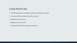
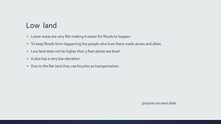
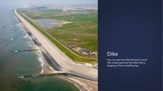
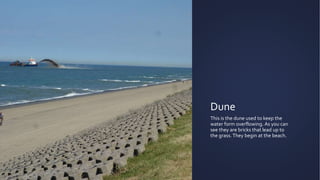
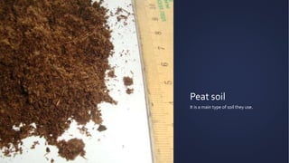
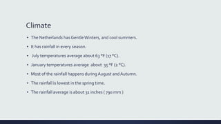
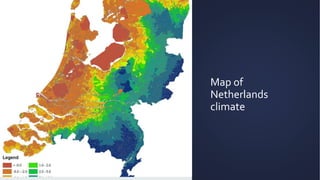
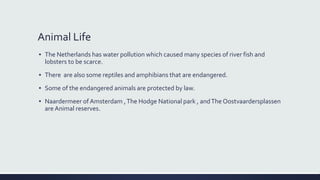
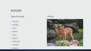
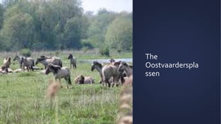
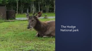
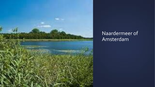
The Netherlands Geography
By: Jayla Green
Table Of Contents
▪ Low land
▪ land
▪ High land
▪ Farmland
▪ North sea
▪ Climate
▪ Animals life
▪ Ending slide
Lands
land/ North sea, low land, farm land and high land
Land/ North sea
▪ The Netherlands are located in Northern,Western Europe.
▪ It is bounded by the sea to north and west.
▪ Germany is at it’s east.
▪ Belgium is at it's south.
▪ About half of the area is below sea level.
The map of the
North Sea
The north sea is the main
source of water.
Low land
▪ Lower areas are very flat making it easier for floods to happen
▪ To keep floods form happening the people who lives there made dunes and dikes.
▪ Low land does not lie higher than 3 feet above sea level.
▪ It also has a very low elevation.
▪ Due to the flat land they use bicycles as transportation.
pictures on next slide
Dike
You can see how flat the land is and
the metal parts are the dike that is
keeping it form overflowing.
Dune
This is the dune used to keep the
water form overflowing. As you can
see they are bricks that lead up to
the grass.They begin at the beach.
High land
▪ The layers of sand and gravel in the eastern part of the country were pushed to the
west and was sent up north in some places that formed ridges and that is how the high
land is made.
▪ These ridges can reach the height of more than 330 feet (100 meters).
▪ The border ofArdennes is where the elevations exceed 350 feet (105 meters) .
▪ Those ridges are the principal feature of the Hoge ParkVeluwe National Park.
▪ The highest land is theVaalserberg, rises to 1,053 feet (321 meters).
The border of
Ardennes
This is the highest elevation.
theVaalserberg
It is the highest peak .
the Hoge Park
Veluwe National
Park
You can see how it is high up.
Farm land
▪ The Rhine and mass river unloaded layers of silt and gravel.
▪ Farmers used peat soil.
▪ Peat soil is a type of soil which is made up of waterlogged decomposed plants.
▪ Peat soil was either dunged out or wash out by the sea.
▪ Peat soil was used for the production of fuel and salt.
Peat soil
It is a main type of soil they use.
Extra
Climate, animal life ,
Climate
▪ The Netherlands has GentleWinters, and cool summers.
▪ It has rainfall in every season.
▪ July temperatures average about 63 °F (17 °C).
▪ January temperatures average about 35 °F (2 °C).
▪ Most of the rainfall happens during August andAutumn.
▪ The rainfall is lowest in the spring time.
▪ The rainfall average is about 31 inches ( 790 mm )
Map of
Netherlands
climate
Another climate
map
Animal Life
▪ The Netherlands has water pollution which caused many species of river fish and
lobsters to be scarce.
▪ There are also some reptiles and amphibians that are endangered.
▪ Some of the endangered animals are protected by law.
▪ Naardermeer of Amsterdam ,The Hodge National park , andThe Oostvaardersplassen
are Animal reserves.
Animals
Type of animals
▪ Roe Deer
▪ Red Deer
▪ Foxes
▪ Badges
▪ Boars
▪ Beavers
▪ Fallow Deer
▪ Mouflons
▪ Muskrat
Picture
The
Oostvaarderspla
ssen
The Hodge
National park
Naardermeer of
Amsterdam
The end
All the information was form
http://www.britannica.com/place/Netherlands#toc35858 .

The netherlands geography

  • 1.
  • 2.
    Table Of Contents ▪Low land ▪ land ▪ High land ▪ Farmland ▪ North sea ▪ Climate ▪ Animals life ▪ Ending slide
  • 3.
    Lands land/ North sea,low land, farm land and high land
  • 4.
    Land/ North sea ▪The Netherlands are located in Northern,Western Europe. ▪ It is bounded by the sea to north and west. ▪ Germany is at it’s east. ▪ Belgium is at it's south. ▪ About half of the area is below sea level.
  • 5.
    The map ofthe North Sea The north sea is the main source of water.
  • 6.
    Low land ▪ Lowerareas are very flat making it easier for floods to happen ▪ To keep floods form happening the people who lives there made dunes and dikes. ▪ Low land does not lie higher than 3 feet above sea level. ▪ It also has a very low elevation. ▪ Due to the flat land they use bicycles as transportation. pictures on next slide
  • 7.
    Dike You can seehow flat the land is and the metal parts are the dike that is keeping it form overflowing.
  • 8.
    Dune This is thedune used to keep the water form overflowing. As you can see they are bricks that lead up to the grass.They begin at the beach.
  • 9.
    High land ▪ Thelayers of sand and gravel in the eastern part of the country were pushed to the west and was sent up north in some places that formed ridges and that is how the high land is made. ▪ These ridges can reach the height of more than 330 feet (100 meters). ▪ The border ofArdennes is where the elevations exceed 350 feet (105 meters) . ▪ Those ridges are the principal feature of the Hoge ParkVeluwe National Park. ▪ The highest land is theVaalserberg, rises to 1,053 feet (321 meters).
  • 10.
    The border of Ardennes Thisis the highest elevation.
  • 11.
  • 12.
    the Hoge Park VeluweNational Park You can see how it is high up.
  • 13.
    Farm land ▪ TheRhine and mass river unloaded layers of silt and gravel. ▪ Farmers used peat soil. ▪ Peat soil is a type of soil which is made up of waterlogged decomposed plants. ▪ Peat soil was either dunged out or wash out by the sea. ▪ Peat soil was used for the production of fuel and salt.
  • 14.
    Peat soil It isa main type of soil they use.
  • 15.
  • 16.
    Climate ▪ The Netherlandshas GentleWinters, and cool summers. ▪ It has rainfall in every season. ▪ July temperatures average about 63 °F (17 °C). ▪ January temperatures average about 35 °F (2 °C). ▪ Most of the rainfall happens during August andAutumn. ▪ The rainfall is lowest in the spring time. ▪ The rainfall average is about 31 inches ( 790 mm )
  • 17.
  • 18.
  • 19.
    Animal Life ▪ TheNetherlands has water pollution which caused many species of river fish and lobsters to be scarce. ▪ There are also some reptiles and amphibians that are endangered. ▪ Some of the endangered animals are protected by law. ▪ Naardermeer of Amsterdam ,The Hodge National park , andThe Oostvaardersplassen are Animal reserves.
  • 20.
    Animals Type of animals ▪Roe Deer ▪ Red Deer ▪ Foxes ▪ Badges ▪ Boars ▪ Beavers ▪ Fallow Deer ▪ Mouflons ▪ Muskrat Picture
  • 21.
  • 22.
  • 23.
  • 24.
    The end All theinformation was form http://www.britannica.com/place/Netherlands#toc35858 .