TES geospatial capture platforms
•Download as PPTX, PDF•
0 likes•104 views

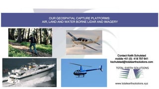
Total Earth Solutions provides geospatial data capture services using airborne, terrestrial, and marine lidar and imagery platforms. They have recently expanded their capabilities with the addition of a Cirrus SR22 GTS aircraft and Optec Galaxy LiDAR unit. Their goal is to offer safer, faster, cheaper, better, and smarter geospatial solutions to clients.

Recommended
Recommended
More Related Content
Recently uploaded
Recently uploaded (20)
Featured
Featured (20)
TES geospatial capture platforms
- 1. OUR GEOSPATIAL CAPTURE PLATFORMS: AIR, LAND AND WATER BORNE LIDAR AND IMAGERY TOTAL EARTH SOLUTIONS www.totalearthsolutions.xyz Contact Keith Schulstad mobile +61 (0) 418 797 641 kschulstad@totalearthsolutions.com
- 2. Contact Keith Schulstad mobile +61 (0) 418 797 641 kschulstad@totalearthsolutions.com TOTAL EARTH SOLUTIONS www.totalearthsolutions.xyz
- 3. Total Earth Solutions – New capability Cirrus SR22 GTS Optec Galaxy LiDAR TOTAL EARTH SOLUTIONS www.totalearthsolutions.xyz Safer Faster Cheaper Better Smarter