
![Marine Alliance for Science and Technology
for Scotland - Overview
• ~700 researchers across 10 key partner institutions
• Initial investment from Scottish Funding Council and partners:
£75m [2009-2016, £34m investments in new appointments and infrastructure]
• Majority of new money – 34 staff – 48 studentships
• Integration of science with policy and regulation
• High level representation
• Promotes and facilitates collaboration and co-operation
- nationally and internationally
• Drives scientific excellence in research and training
• Provides critical mass](https://image.slidesharecdn.com/terawattdhiusergroupvoglerpublic-130328103854-phpapp02/85/TeraWatt-Project-3-320.jpg)
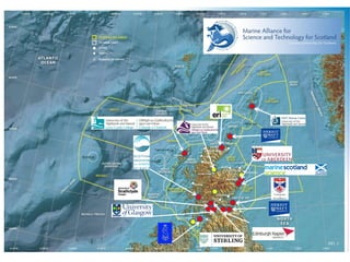
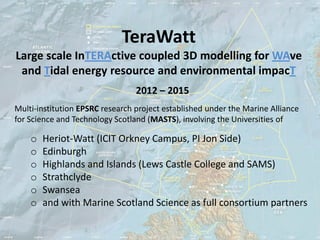
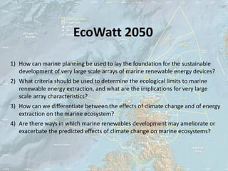
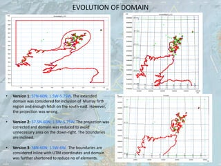
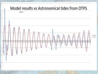
![Significant wave height – Model Validation
with CEFAS Buoy @ 57°17'.52N and 07°54'.84W in 103m of water
Cefas Buoy: Sign. Wave Height [m]
Sig Wave Ht [m]
D:Hebrideswave_dataCefas BuoyMarch 2012Cefas March 2012.dfs0
odel InputsHebridean_final_OperationalData.sw - Result FilesPoint_0_125deg_March2012_operational.dfs0
12
11
10
9
8
7
6
5
4
3
2
00:00 00:00 00:00 00:00 00:00 00:00
2012-03-02 03-07 03-12 03-17 03-22 03-27](https://image.slidesharecdn.com/terawattdhiusergroupvoglerpublic-130328103854-phpapp02/85/TeraWatt-Project-15-320.jpg)
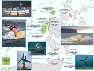
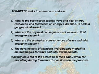
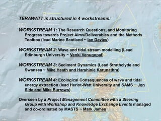
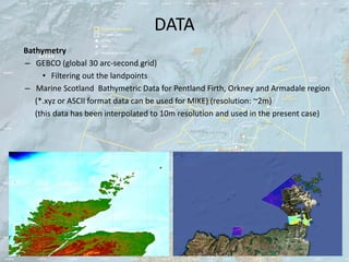
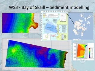
![Zero Crossing Period – Model Validation
with CEFAS Buoy @ 57°17'.52N and 07°54'.84W in 103m of water
Cefas Buoy: Wave Period, T02 [sec]
Tz [sec]
D:Hebrideswave_dataCefas BuoyMarch 2012Cefas March 2012.dfs0
lModel InputsHebridean_final_OperationalData.sw - Result FilesPoint_0_125deg_March2012_operational.dfs0
13.0
12.0
11.0
10.0
9.0
8.0
7.0
6.0
00:00 00:00 00:00 00:00 00:00 00:00
2012-03-02 03-07 03-12 03-17 03-22 03-27](https://image.slidesharecdn.com/terawattdhiusergroupvoglerpublic-130328103854-phpapp02/85/TeraWatt-Project-16-320.jpg)


The document outlines the Terawatt project, a collaborative research initiative that investigates the environmental and ecological impacts of wave and tidal energy extraction in Scotland. It details the project’s structure, objectives, workstreams, and methodologies, involving multiple academic institutions and industry partnerships. Additionally, it describes related projects like Ecowatt 2050, which focuses on marine planning for sustainable development in renewable energy.


