T3g pd gis_presentation_aag2018_final
•Download as PPTX, PDF•
1 like•80 views

This document summarizes a multi-year professional development institute (T3G) for educators in GIS. The T3G aimed to teach educators how to teach GIS to other educators and apply it in their classrooms. A survey of T3G participants found that it helped educators learn GIS skills and concepts to incorporate into their teaching. While the T3G evolved over time, the survey showed it successfully enabled educators across disciplines and levels to teach with GIS. The study concludes by calling for more research on the effectiveness of GIS professional development programs.

Recommended
More Related Content
What's hot
What's hot (10)
Similar to T3g pd gis_presentation_aag2018_final
Similar to T3g pd gis_presentation_aag2018_final (20)
More from Michael DeMers
More from Michael DeMers (20)
Recently uploaded
Recently uploaded (20)
T3g pd gis_presentation_aag2018_final
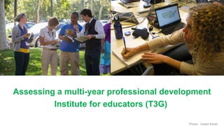
- 1. Photos: Joseph Kerski Assessing a multi-year professional development Institute for educators (T3G)
- 2. Michael N. DeMers, PhD, New Mexico State University, demers01@gmail.com Christopher Sroka, PhD, New Mexico State University, csroka@nmsu.edu Joseph J. Kerski, PhD GISP, Esri, University of Denver jkerski@esri.com
- 3. Setting • The use of GIS in education dates to the early 1990s. • GIS in education research to date has focused on: 1. Student effectiveness 2. Evaluation of the tools 3. Assessment of the impact of GIS on educators. ●
- 4. Global Challenges Source: Joseph Kerski
- 5. GIS is becoming the language of the planet Source: Esri
- 6. GIS: A standard instructional approach and toolset? Source: Esri
- 8. Why study the T3G institute? • Long-running with similar instructional staff, goals, setting, application process. • Required the same post-institute deliverables: (1) an authored piece of curriculum that uses GIS as one of its main tools for inquiry, (2) a presentation at a conference or other event on the use of GIS in education, and (3) an active engagement with one or more online or face-to-face networks of educators using GIS.
- 9. T3G Goal: Teachers Teaching Teachers GIS. Not “I want to learn more GIS to teach in my class” – but “how can I teach other faculty colleagues/administrators/others in education” why and how can GIS and spatial analysis be used in education. Hence, focus on T3G is skills in context – pedagogy is integrated throughout. Teaching about and with GIS. Target audience: 2009-2012 Educators but then 2013- 2018: Educators and Influencers.
- 12. T3G Themes Instructional and Technical Skills Local Fieldwork and Mapping Mapping and Analysis: Spatial Thinking Big Picture Accountability: Action Plan Teaching other educators about GST
- 17. T3G reflects 11 Broader Trends in GIS in Education: 1. GIS spreading to all levels of education. 2. GIS used in a ever-widening array of disciplines. 3. Desktop Cloud-Based GIS. 4. Focus on STEM education. 5. Emphasis on field work, citizen science, crowdsourcing. 6. Teaching with GIS and teaching about GIS. 7. Expanding from key users/instructors to “influencers.” 8. Use of the Geospatial Technology Competency Model. 9. Dedicated lab Bring your own device. 10.The “Internet of Things” – geo-enabled devices, and their implications (location privacy, big data, data quality). 11. In primary-secondary, GIS increasing in standard course content delivery
- 18. Source: Esri and USGS. Map Author: Joseph Kerski
- 19. Source: Esri.
- 20. Source: Esri and USGS. Map Author: Joseph Kerski.
- 22. Source: Esri.
- 23. Source: Esri. Author: Joseph Kerski
- 29. Analysis
- 30. GIS and STEM Table 1. Characteristics of Survey Respondents
- 31. GIS and STEM Table 1. Charac teristics of Survey Respon dents, part 2
- 32. Comparison of educator roles in pre-2012 cohort to educator roles in post-2012 cohort
- 33. GIS and STEM Respondent rankings of how T3G helped them teach with GIS
- 34. GIS and STEM Respondents' rankings of how often they are promoting GIS in education
- 35. % of Time Devoted to Online GIS Tools 0 10 20 30 40 50 60 70 80 90 100 2009 2010 2011 2012 2013 2014 2015 2016 Year Year
- 36. GIS and STEM Respondents' scores of the extent to which T3G aided them in teaching with GIS
- 37. GIS and STEM Comparison of GIS components used by pre-2012 cohort to components used by post-2012 cohort
- 38. Conclusions • The T3G institute met its goals of equipping educators so that they could (1) teach GIS concepts and skills for their peers, (2) create GIS-based curricula, and (3) communicate the value of GIS to other disciplines.
- 39. Conclusions • While the institute evolved in size, scope, audience, and technological focus, the survey indicated the overall success of T3G to enable educators across many institutional types and levels to teach with GIS.
- 40. Conclusions • While highly structured, the workshop purposely involved a modicum of confusion in accordance with the “cognitive disequilibrium” principle and the instructors provided methods of improving participants’ self-regulation skills; in particular those related to assessing improvement of learning how to teach with GIS.
- 41. • Overall, the institute provided both intended and unintended learning objectives and suggested best practices for future GIS professional development workshops. • PD for educators in GIS is likely to remain a key enabler of the advancement of GIS in educational institution. To make certain that these PD opportunities are as effective as possible, continued studies are needed so that models for best practice can be developed, shared, and modified around the world. • One challenge of T3G and other face to face models was assembling busy educators in one place for multiple days.
- 43. Source: Esri 6,500 K-12 schools w/ArcGIS Online accounts
- 44. Recommendations • We call upon the community to gather pre- and post-workshop data for their own series of workshops to add to the body of research in the effectiveness of faculty development opportunities in GIS. • We propose that it would be a worthwhile effort for the GIS education community to devise a rubric including a pre- and post-test that researchers can use to assess a broad spectrum of professional development institutes for educators. • We need studies in the effectiveness of online GIS institutes as web- and hybrid-based trainings, courses, and workshops become more common.
- 45. Michael N. DeMers, PhD, New Mexico State University, demers01@gmail.com Christopher Sroka, PhD, New Mexico State University, csroka@nmsu.edu Joseph J. Kerski, PhD GISP, Esri, University of Denver jkerski@esri.com
Editor's Notes
- Joseph: T3G Goal: Teachers Teaching Teachers GIS. (1) Not “I want to learn more GIS to teach in my class” – but “how can I teach other faculty colleagues/administrators/others in education” why and how GIS and spatial analysis can be used in education. Hence, (2) focus on T3G is skills IN context – pedagogy is integrated throughout. Teaching ABOUT and WITH GIS. Target audience: (3) Educators but then in 2013: Influencers.
- Joseph: Notably, the participants are distributed all over the US and in a few locations abroad. Of note is that certain states with strong support at the K-12 and university level are particularly well represented: NH and VA.
- Joseph: Themes running throughout T3G include these pictured here. But it is also important to note that, like Woodstock, T3G is not just a week long. It is a “habit of mind” that is embedded throughout the year in the community’s events, including webinars, social media, action plan, and so on.
- Joseph: The 3 legged stool is integrated into all of the T3G activities. It serves to reinforce the point we made earlier that T3G is not just a skill builder or tech refresher.
- Joseph: Inquiry runs through each activity, short or long.
- Primary methodology is one of learning in community based on the basic pieces of 1 (Faculty guidance, teamwork, and mutually negotiated goals), 2. Facilitation and collaborative learning, 3 Interaction and feedback, action creation and knowledge meaning, and 4. Buy-in, shared goals, and focused outcomes. In short this is a classic constructivist model of learning.
- A hallmark of the T3G program as a professional development program is that it brings together a wide array of disciplines, all of whom have a variable interest in GIS both as an application and as an enabling technology. The cross-disciplinary collaboration that result was truly inspirational.
- Joseph:
- Making web and story maps.
- Joseph: Fieldwork has always been important to T3G and We believe it should be included in all PD for educators. In 2012, we began using editable online maps, where everyone collects data on specific themes, and then maps them. These 4,000 points were gathered in 90 minutes by 90 educators at the T3G 2013 institute for a section of Redlands, California.
- Here you see the Esri Auditorium with nearly 100 participants using a wide array of tablets and laptops and different operating systems. From a participant’s perspective this was fabulous because we each began working with our own machines with which we were familiar, and often with which we might very well still be working when we returned. I found it nice having all the course materials on the same machine when I got home after this experience. It provided a nice transition into the implementation of the principals and techniques immediately.
- Joseph: This photo mosaic better than any words we could say, encapsulates T3G’s mission. Collaboration. Fieldwork, inquiry, reflection, maps, analysis, engaging, fun.
- Within any of the curricula there is an underlying belief that a major outcome should be an improved ability to observe, describe, analyze, explain and even exploit spatial patterns. This critical spatial thinking is at the heart of most, if not all GIS education, regardless of the curricula itself.
- Another hallmark of the program is that it promotes learning at all levels from Kindergarten through college and graduate school and beyond. By enabling K-20 educators it disseminates the information to those reaching the K-20 learners. It also enables both the educators and their learners for lifelong learning.
- Joseph: Percent of hands-on activity time 2009-2014 devoted to online GIS tools.
- Joseph: T3G requires instructors to think outside their own comfort zone: In reaching beyond their own classrooms with spreading the why and how of spatial analysis, with using new tools and new instructional methods. But in so doing, we hope to move the fence on what is possible with spatial analysis in education.