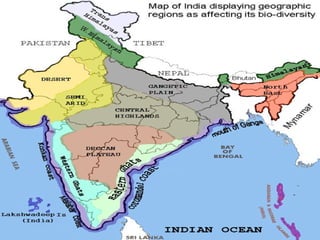
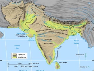
 The peninsular plateau is a tableland composed of
the old crystalline, igneous and metamorphic rocks.
It was formed due to the breaking and drifting of
the Gondwanaland and thus making it a part of the
oldest landmass.
 This plateau consists of two broad divisions:
 Central highlands
 Deccan plateau.
I.     The part of Peninsular plateau lying to the north of
      the Narmada river covering a major area of the
      Malwa plateau is known as the Central Highlands.
II.    The Vindhyan range is bounded by the central
      Highlands on the south and the Aravalis on the
      northwest.
III. The further westward extension gradually merges
     with the sandy and rocky desert of Rajasthan.
 The flow of rivers draining this region, namely the
Chambal, the Sind, the Betwa and Ken is from southwest
to northeast, thus indicating the slope.
 The central Highlands are wider in the west but
narrower in the east.
 Eastward extention: 1. Bundelkhand
                        2. Baghelkhand
                        3. The Chotanagpur plateau
drained by
                          Damodar river.
ular iver
                                  riang the r
                        u  is a t th of
                  latea the sou
           can P es to
  Th e Dec at li                                     anks.
        s th                                  ge fl
    dmas                                 a Ran
lan      a .                      atpur
    rmad                   : 1. S
 Na                  eccan                 hadev
             h ern D               T he Ma              hills
       Nort                 : 1.                  imur
                    eccan             2. T he Ka
               ern D
        East                                         range
     
                                         3. M aikal
i. It extends over eight Indian states and encompasses a wide
   range of habitats, covering most of central and southern India.
ii. It is located between three mountain ranges: the Western
   Ghats form its western boundary, and the Eastern Ghats its
   eastern boundary.                An extension of the plateau is also
                                   visible in the northeast- locally known as
                                   the Meghalaya, Karbi-Anglong Plateau
                                   and North cacher hills. It is separated
                                   by a fault from the Chotanagpur
                                   Plateau. Three prominent hills ranges
                                   from the west to east are the Garo, the
                                   Khasi and the Jaintia hills.
i. Western Ghats lie parellel to the
   western coast
ii. They are continuous and can be crossed
   through passes only.
iii. Western Ghats are higher than
   Eastern Ghats.
iv. The average elevation is 900 – 1600
 The Eastern Ghats stretch from the Mahanadi
valley to the Nilgiris in the South
 The Eastern Ghats are discontinuous and irregular
and dissected by rivers draining into the Bay of
Bengal.
A. Anai Mudi – 2695mts
   [Western Ghats.]
B. Doda Beta – 2637mts
  [Western Ghats.]
C. Mahendragiri – 1501mts
   [Eastern Ghats.]
 Shevroy hills

 Javadi Hills
 These are located in Southeast of Eastern Ghats.


 Kodaikanal
 Ooty [Udagamandalam]
Sst ppt
Sst ppt
Sst ppt
Sst ppt
Sst ppt

Sst ppt

  • 2.
     The peninsularplateau is a tableland composed of the old crystalline, igneous and metamorphic rocks. It was formed due to the breaking and drifting of the Gondwanaland and thus making it a part of the oldest landmass.  This plateau consists of two broad divisions:  Central highlands  Deccan plateau.
  • 3.
    I. The part of Peninsular plateau lying to the north of the Narmada river covering a major area of the Malwa plateau is known as the Central Highlands. II. The Vindhyan range is bounded by the central Highlands on the south and the Aravalis on the northwest. III. The further westward extension gradually merges with the sandy and rocky desert of Rajasthan.
  • 4.
     The flowof rivers draining this region, namely the Chambal, the Sind, the Betwa and Ken is from southwest to northeast, thus indicating the slope.  The central Highlands are wider in the west but narrower in the east.  Eastward extention: 1. Bundelkhand 2. Baghelkhand 3. The Chotanagpur plateau drained by Damodar river.
  • 5.
    ular iver riang the r u is a t th of latea the sou can P es to Th e Dec at li anks.  s th ge fl dmas a Ran lan a . atpur rmad : 1. S Na eccan hadev h ern D T he Ma hills Nort : 1. imur  eccan 2. T he Ka ern D East range  3. M aikal
  • 6.
    i. It extendsover eight Indian states and encompasses a wide range of habitats, covering most of central and southern India. ii. It is located between three mountain ranges: the Western Ghats form its western boundary, and the Eastern Ghats its eastern boundary.  An extension of the plateau is also visible in the northeast- locally known as the Meghalaya, Karbi-Anglong Plateau and North cacher hills. It is separated by a fault from the Chotanagpur Plateau. Three prominent hills ranges from the west to east are the Garo, the Khasi and the Jaintia hills.
  • 7.
    i. Western Ghatslie parellel to the western coast ii. They are continuous and can be crossed through passes only. iii. Western Ghats are higher than Eastern Ghats. iv. The average elevation is 900 – 1600
  • 8.
     The EasternGhats stretch from the Mahanadi valley to the Nilgiris in the South  The Eastern Ghats are discontinuous and irregular and dissected by rivers draining into the Bay of Bengal.
  • 9.
    A. Anai Mudi– 2695mts [Western Ghats.] B. Doda Beta – 2637mts [Western Ghats.] C. Mahendragiri – 1501mts [Eastern Ghats.]
  • 10.
     Shevroy hills Javadi Hills  These are located in Southeast of Eastern Ghats.  Kodaikanal  Ooty [Udagamandalam]