On 1/26/17 the Bay Area Open Space Council convened its Winter Gathering on the topic of projects, issues, and opportunities for protecting wildlife corridors in the Bay Area. More about it at #OSCwildlife on Twitter, and http://openspacecouncil.org/community-events/gatherings/
Bruce Fulford, Owner, City Soil
The linkages between urban farms, conservation foundations, and municipalities can all reinforce the power of urban agriculture. Bruce Fulford describes creating agricultural land in an urban setting.
Presented at the Urban and Suburban Carbon Farming to Reverse Global Warming conference at Harvard University on May 3, 2015, organized by Biodiversity for a Livable Climate.
www.bio4climate.org
The document summarizes Anne Williams' work with no-till farming techniques on her property "Magomadine" in NSW, Australia. Some key findings include increased yields and profits from no-till, up to a 20% increase in cotton yields from using compost, and conducting further research into biological soil amendments and their effects.
How Low Can We Go: Nitrogen in Dairy Rations- Mike McMahonDAIReXNET
McMahon’s EZ Acres Farm is located in Central New York. It is owned by two brothers and has soils of varying drainage qualities. The farm has 675 cows and typically 545 heifers. It is located near a municipal well and protected trout stream. More nutrients are imported onto the farm as purchased feeds than are exported in milk and animals, with the remainder accumulating on the farm or being lost to the environment and causing air and water quality issues. One approach to address this is to minimize imports and maximize the use of existing nutrients by recycling manure on the farm through practices like growing feed crops, intensive grasslands, and storing manure for flexible application.
The Harvest Green Court Outfall Restoration Project in Fairfax County, Virginia restored 407 linear feet of eroded channel located in a Resource Protection Area. The project stabilized the channel using natural stream design techniques like imbricated stone step pools and reinforced bed mix riffle sections. Native vegetation was also planted to reduce nitrogen, phosphorus, and suspended solid levels in the waterway. The restoration project addressed public safety concerns and improved water quality in the Sugarland Run Watershed.
Abi Burns' presentation from the Sustainable Food Trust's meeting: What role for grazing livestock in a world of climate change and diet-related disease?
This document summarizes the water features and flow patterns on a homestead property located at the base of Wilbraham Mountain in Massachusetts. It identifies three main streams that flow across the sloped property from northeast to southwest, emptying into wetland areas. Soil maps show muck soils in the northern and southern wetlands. The document outlines challenges around water collection and transport for irrigation, and proposes catchment and greywater systems to better manage water distribution across the farm.
Mountains provide water for over 1 billion people downstream but climate change threatens this supply. Glaciers are retreating in most areas except the Karakorum and changes in timing and amounts of runoff increase risks of floods and droughts. Meeting future food, energy, and development needs while minimizing additional water use will require improved management including reducing vulnerabilities, finding solutions across sectors, better landscape and watershed practices, valuing mountain ecosystems, addressing data gaps, and prioritizing mountains globally.
myequivalents is a system to manage cross-references between entities that can be identified by pairs composed of a service name (e.g., EBI's ArrayExpress, Wikipedia) and an accession (e.g., E-MEXP-2514, Barack_Obama). For those familiar with the Semantic Web, we plan to support identification of entities via URIs and the owl:sameAs property. For those who already know MIRIAM and identifiers.org, myequivalents is more general than them and we plan to support these services in future.
This social media marketing plan template outlines 10 steps to develop an effective social media strategy. It includes defining key issues and desired outcomes, gauging your existing online presence, conducting a SWOT analysis, determining online competition, setting SMART objectives, segmenting and targeting audiences, choosing appropriate social media tools, developing a press release, measuring performance, and ongoing monitoring and adjustments. The template provides guiding questions under each step to help structure the planning process.
A few notes here about the UK Ontology Network Meeting (http://dream.inf.ed.ac.uk/events/ukont-13/2013_workshop_program.html) I've attended on 11/Apr/2013.
El documento describe los procedimientos básicos para mover cargas unitarias, incluyendo levantar la carga debajo de ella, insertar un elemento de elevación dentro de la carga, prensar la carga entre dos superficies elevadoras, y suspender la carga. También describe tipos de cargas unitarias como patines, paletas, cargas sobre láminas o bastidores, cargas en recipientes, y cargas independientes. Finalmente, discute las relaciones entre cargas unitarias y otros factores como vehículos, recipientes para despacho, soport
This document summarizes the water analysis of Tattersall Farm. It identifies five sources of water entering the property, including streams and drainage from surrounding areas. Water exits the farm at three points, draining into surrounding wetlands and Creek Brook. The document also notes the soils, slopes, absence of flooding areas, and one area exposed to road runoff. Mapping water flows and sources is important for sustainable farm design.
The document discusses the impacts of climate change on Maine's forests and what is known and unknown. It notes that climate change will stress some tree species like sugar maple and alpine ecosystems. Effects on pests, diseases and invasive species are still being studied. The rate of climate change also poses challenges for forest adaptation. While models project large changes, other research suggests some forest types may remain stable. The document calls for more citizen science data collection and notes challenges in managing forests for carbon storage, resilience and biodiversity under climate change.
This document provides an overview of the Pathfinder Ranches Resource Conservation Mitigation Bank Project in Wyoming. The project was conceived in 2007 to protect over 60,000 acres of ecologically important land containing 134.6 miles of streams and 1,423 acres of wetlands. The project aims to restore degraded streams and wetlands to provide mitigation credits for future development impacts within an 84,587 square mile service area. Technical design is led by Trout Headwaters, Inc to ensure the ecological viability and self-sustainability of restoration efforts over time in line with goals to compensate for habitat losses and contribute to watershed functioning.
The document summarizes the minutes from the November 20, 2008 meeting of the WCB Board. It discusses several items including land management plans in Tehama and Shasta Counties, expansions of ecological reserves and wildlife areas, habitat restoration projects, and a revised conservation easement monitoring policy which establishes requirements for grantees to monitor properties and report any violations.
Lawn Care and Maintenance helps your yard look beautiful and stay healthy. We understand a lawn isn't just grass - it's an investment. An investment of not only time and money, but also of dreams and memories. Of course you want your yard to look perfect. Our Lawn Doctor Maintenance Services can help you achieve the perfect lawn you've always wanted.
This document is a preliminary forest conservation plan for the Scotland Heights property in Charles County, Maryland. It identifies 6 forest stands on the property and provides details on the forest composition, health, and environmental features of each stand. It also outlines plans for final forest conservation, construction timetables, reforestation efforts, and planting specifications to protect forests on the site during and after development. The plan was prepared by ATCS, PLC to comply with Charles County forest conservation regulations for the proposed residential development of the property.
This document is a preliminary forest conservation plan for the Scotland Heights property in Charles County, Maryland. It identifies 6 forest stands on the property and provides details on the forest composition, health, and environmental features of each stand. It also outlines plans for final forest conservation, construction timetables, reforestation efforts, and planting specifications to protect forests on the site during and after development. The plan was prepared by ATCS, PLC to comply with Charles County regulations for forest conservation.
Permaculture Design Project for Wild Meadows Farm prepared for Permaculture Certificate Course 2005. Reviews permaculture principles and applies to 195 acre PA farm. Reviews farm characteristics and includes one and 5 year plan for transition to organic management and permaculture management
David Asbury owns and operates several organic farms in Colorado, including Full Circle Farms and Rocky Mountain Pumpkin Ranch. He recently purchased Strawberry Hill Farm, a five-acre property that had been neglected. The mission is to design an organic commercial apple orchard on the property that includes soil-enriching plants and creates a regenerative environment for people, wildlife, and plants. The design divides the property into zones, with Zone 1 focusing on the area around the house, adding landscaping for outdoor living spaces, drainage solutions, and noise buffers to address challenges from the nearby highway.
This document provides an inventory and analysis of Little Mountain Ranch, an 1800-acre property in Highland County, Virginia. It identifies three distinct landscape types on the property: the flat riverine floodplain along the Jackson River; moderate to steep transitional slopes between the floodplain and ridge top; and the rocky, steep ridge top. The analysis covers terrain, ecology, vegetation, aspect, and wildlife and was conducted to inform planning and design decisions for the property.
The document discusses the regional distribution and significance of various natural resources and industries in the United States. It outlines the major fishing, forestry, agricultural, mineral, energy, and industrial regions. Key regions include the Southeast for forestry, the Cotton Belt and Corn Belt for agriculture, the Lake Superior region for iron ore, the Appalachians for coal, and regions along major river valleys for hydroelectric power generation and petroleum production.
This document provides a conceptual restoration plan for a closed landfill located on Curve Lake First Nations land in Ontario, Canada. The plan aims to address issues like potential groundwater contamination from the landfill and restore native plant species. Key elements of the plan include removing garbage from the landfill; monitoring groundwater quality; replanting native tree, shrub and plant species; and long-term management through annual water and soil sampling and vegetation monitoring. The estimated budget is $172,668 and the projected timeline is from May 2016 to September 2026. Funding will be sought from environmental grants and community fundraising.
The document provides information on recent construction progress for the Willits Bypass project in California. It discusses how the mild winter weather has allowed fill operations and bridge construction to stay on schedule. The last deck pour for the viaduct was completed in late July. By the end of the construction season, the bypass will be drivable from one interchange to the other. Next season will focus on completing remaining work and paving so the project can be finished by November 2016. The summary also briefly discusses decisions around using herbicides for mitigation parcels.
The document proposes planting native vegetation along 950 linear feet of the eastern shoreline of the UMass Campus Pond to stabilize eroding banks and protect wetland resource areas. Plantings will include trees, shrubs, grasses and wildflowers suitable for wetland areas. Invasive species will be removed through pruning and herbicide application. Plantings are aimed to reduce erosion, improve water quality, provide habitat and allow for potential expansion of wetland areas. The work will be conducted over three to five years using best practices for erosion control and protecting water quality in the pond.
Similar to Sierraview Tree Farm Stewardship Plan (16)
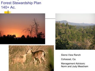
Design an efficient and functional grow room for your indoor cultivation by installing a PVC grow wall. PVC walls are designed for easy and time-effective installation.
PVC panels have a non-porous and smooth surface that is crevice-free because of the tongue and groove interlocking. These panels effectively reflect light, making for a bright interior and enhancing the efficiency of artificial lights. A well-lit grow room will improve plant growth and assure better yield.
Furthermore, PVC panels are easy to clean and maintain. They need only a damp cloth and mild detergent for a clean and hygienic surface. Besides being resistant to chemicals, they do not succumb to the use of cleaning agents.
Opt for PVC panels for grow room wall material to improve the functionality of the space.
Reach us : https://www.duramaxpvcpanels.com/applications/grow-rooms/
The SVN® organization shares a portion of their new weekly listings via their SVN Live® Weekly Property Broadcast. Visit https://svn.com/svn-live/ if you would like to attend our weekly call, which we open up to the brokerage community.
🌟 Find Your Balance with Oree Reality
Happy International Yoga Day! 🌿 At Oree Reality, we believe in the harmony of mind, body, and home. Just as yoga brings balance and peace, finding the perfect home can do the same for your life.
Signature Global TITANIUM SPR | 3.5 & 4.5BHK High rise Apartments in Gurgaonglobalsignature2022
Signature Global TITANIUM SPR launched a high rise apartments in Gurgaon . In this project Signature Global offers 3.5 & 4.5 BHK high rise Apartment at sector 71 Gurgaon SPR Road. Signature Global Titanium SPR is IGBC Gold certified, a testament to our commitment to sustainability.
Listing Turkey - Piyalepasa Istanbul CatalogListing Turkey
We are working around the clock to transform a long-time dream into reality. As a result, Piyalepasa Istanbul will be the largest privately developed urban regeneration project in Turkey.
THE NEIGHBORHOOD WE HAVE BEEN LONGING FOR IS COMING TO LIFE
The good old days of the Piyalepasa neighborhood are being brought back to life with Piyalepasa Istanbul houses, residences, offices, hotels and a pedestrianized shopping avenue.
The wide streets of this 82.000 square meter development conveniently face the main boulevard in a prime Beyoglu location. “Piyalepaşa İstanbul” stands out as the only project designed to offer a neighborhood lifestyle, complete with its grocers, bagel sellers and greengrocer. Piyalepasa Istanbul has all the values to make it an authentic neighborhood, our very own community.
A NEIGHBORHOOD FULL OF LIFE, IN THE HEART OF THE CITY!
“Piyalepaşa İstanbul” is a “mixed-use” concept containing all the elements for a vibrant social life with houses, residences, offices, hotels and high street shopping.
“Piyalepaşa İstanbul” will take the liveliness of Istanbul into its heart. The elegant sparkle of Nisantasi, the young and colorful Besiktas, the variety and multicultural heritage of Istiklal Street will all be contained within the streets of this neighborhood.
“Piyalepaşa İstanbul” bears traces of the most beautiful examples of Turkish architecture from the Seljuks to the Ottomans and from Anatolia to Rumelia. With its graded facades, wide eaves, bay windows, pools, and interior courtyard systems, it offers a new living space without disrupting the city’s silhouette and neighborhood.
“Piyalepaşa İstanbul” is the new attraction of this splendid city.
TO BE AT THE CENTER OF ISTANBUL… THIS IS REAL LUXURY!
With its proximity to D-100 highway, connecting roads and tunnels, “Piyalepaşa İstanbul” is only minutes away from Kabatas, Besiktas, the Golden Horn and Karakoy.
“Piyalepaşa İstanbul” is close to the prestigious new Istanbul Court House, a major hospital, the Perpa trade center and the city’s most lively neighborhoods. With its shuttle service to Okmeydani Metrobus station, Sishane and the Court House subway stations, “Piyalepaşa İstanbul” will provide you with the most convenient transport connections.
https://listingturkey.com/property/piyalepasa-istanbul/
Andhra Pradesh, known for its strategic location on the southeastern coast of India, has emerged as a key player in India’s industrial landscape. Over the decades, the state has witnessed significant growth across various sectors,
Here we will discuss the real estate investment checklist that will help you make an informed decision when investing in Indore.
Real estate investment is a popular way to grow your wealth and secure your financial future. It involves buying, owning, and managing a property for the purpose of generating income or appreciation.
Expressways of India: A Comprehensive Guidenarinav14
India’s expressway network is a testament to the nation’s dedication to improving infrastructure and connectivity. These high-speed corridors facilitate seamless travel across vast distances, reducing travel time and fuel consumption
36,778 sq. ft. building; Zoning: SE (Suburban Employment): The (SE) District allows numerous commercial site uses; Passenger elevator; Private and common restrooms; Fully sprinkled; Data center with a grounded floor and a specialized HVAC system; 60 KVA back-up generator; Building/pylon signage; Potential to purchase adjacent parcels; Sale Price: $4,413,360
Why is Revit MEP Outsourcing considered an as good option for construction pr...MarsBIM1
Outsourcing MEP modeling services require effective collaboration and coordination amongst multiple engineering trades. The engineers and the designers often change the details of the MEP projects, but the work of Revit MEP drafting services is having the master plan and model of the complete project. To have proper coordination and installation, there is a need to execute the project effectively. Hence, the work of Revit family creation facilitates the MEP engineers.
When it comes to purchasing a house in Indore, you'll often find yourself facing a crucial decision: should you pay in cash or opt for financing?
In the realm of real estate, the age-old debate between paying for a house in cash or financing it through a mortgage is a topic that continues to intrigue prospective buyers.
2. 01/28/15
Sierra View Ranch
140 acres
Maintenance
Road
Spur to south and thru the
timber of stand 3
Spur to artesian spring
Access via Ponderosa Way
and Royal Forest Trail
Road.
Muddy Creek
Main residence and
office.
Barn/work shed
3. 01/28/15
Property Overview
Property sits on a ridge running North and South with saddle
on the south boundary adjoining Musty Buck Reserve. The
boundaries form a backward L shape with six distinct stands.
The majority of the property experienced a fire in the late 90’s
with subsequent logging. Natural seeding occurred with a
good population of ponderosa pine seedlings 1-9yrs old.
California Manzanita has overwhelmed the logged off areas,
which in turn has allowed other undesirable lower story plants
to spread and compete with the new pine growth.
4. 01/28/15
Sierra View Ranch Goal
Our objectives require a strong relationship
with the natural and native eco-habitat. The
economics and development of the property
shall drive towards the most current and
accepted methodologies to encourage
maximum tree growth, healthier natural
habitat, emphasis on native plants, soil
improvement, alternative green options,
aesthetic enhancement, and economic gain.
6. 01/28/15
Property Diversified
There are 6 distinct stands associated with Sierra
View Ranch. Stands do not necessarily mean timber
related.
Stand 1- Ridge stand, runs north and south at the
center of the property and supports a thick new
growth of Ponderosa and Sugar Pine softwoods ages
from 1-9 years.
Stand 2- East Slope stand runs north and south and
slopes steeply down to Muddy Creek and has running
water or sporadic pooling of water. This is the major
habitat for black bear, coyote, deer, mountain lion
and upland bird population.
7. 01/28/15
Property Diversified
Stand 3- Southwest stand is a mixture of
second growth ponderosa (25-40yrs, 8” and
up, some tree deformity) and sugar pine (15-
25yrs, 4” and up, tree deformity, some tree
health issues and insect damage.
Stand 4- West Juvenile stand has mixture of
softwoods, primarily Ponderosa and Sugar
pine. (10-20yrs, not much deformity or
damage, growth is being stunted from
overcrowding conditions.
8. 01/28/15
Property Diversified
Stand 5- Rock Outcrop stand is just east of the
juvenile stand and abuts the western slope of the
main north south ridge of Sierra View Ranch. It
lies at 2300’ elevation with a fragmented
limestone layer which has a moisture seam. At
the NE corner of this stand normally lies a year
round artesian spring. There is limited hardwood
trees with undesirable weeds and unidentified
plants. There is an access spur which is
generally passable during the summer months.
9. 01/28/15
Property Diversified
Stand 6- Center stand runs along the properties
center ridge and the inside mid point to the southwest
stand and to the west meeting with the Rock Outcrop
stand. Mixture of second growth and old growth
ponderosa and smaller Sugar pine. Limited hardwood
trees.
There is a maintenance road that branches off
through the Southwest stand, spur road to the spring
and continues onto neighboring property, and a spur
to the south center of the property.
10. 01/28/15
Primary Objectives
Fuel Reduction
Each stand will be prioritized
with objectives met over a
five year transition period.
Reducing the manzanita
stands, using mulch
technology, manual and
mechanical means.
Allowing larger stands of
manzanita growing paths,
targeting new growth for
clearing and mulching,
provides limited manzanita
expansion.
11. 01/28/15
Primary Objectives
Native Covering
As each phase of manzanita removal occurs, a combination
of localized native species and acceptable lower story
species as recommended by Butte County Ag Department
will be utilized in new plantings.
12. 01/28/15
Primary Objectives
Soil Improvement
Mulching methods and soil treatments as
outlined by Butte County Ag will be
implemented.
Natural and native flora will be major accent of
reseeding and planting stages.
13. 01/28/15
Primary Objectives
Wildlife Habitat
Water is major setback for
higher elevations of the
property. Introducing a
water recovery system
design for collection
during winter runoff for
use during summer and
autumn dry months. The
current lower story and
major California
manzanita growth gives
excellent cover, nesting,
and protection for all
species in several stands
and will be enhanced by
introducing watering
systems to aid with natural
influences.
14. 01/28/15
Primary Objectives
Timber Growth
Reduce overcrowding
conditions, remove
diseased, deformed, or
insect damaged trees
with 25’-35’ spacing
which will open the
timber stand.
Potential economic
gains through firewood,
limited building needs
from tree removal, and
other means
determined during all
phases objectives.
15. 01/28/15
Alternative Green Options
Solar Arrays
With the unobstructed eastern and
southerly views solar power is a viable
potential for clean energy for the ranch
needs and also could be of a size and
nature to produce larger amounts of solar
energy for Butte county.
16. 01/28/15
Alternative Green Options
Wind Generation
The natural canyon formed by Muddy
Creek runs north - south to southwest and
allows strong westerly winds, perfect wind
trough for both northern and eastern winds
Follow up studies, data collection and site
surveys will be necessary before moving
into this direction
17. 01/28/15
Aesthetic Enhancements
General Improvements
The blending of buildings and improvements
with the natural lay of the land.
Reduce disturbance of natural habitat.
Proper road maintenance with correct
crowning.
Overall development of Sierra View Tree
Ranch will take on a natural aesthetic value
tempered with well thought out procedures
and practices.
18. 01/28/15
Closing Overview
Sierra View Tree Ranch
This is a 10-20 year plan and will use many
different methodologies and techniques that will
not be discussed fully as they may change over
the duration of the plan. Certain phases may take
longer and/or be a continuous implementation of
recognized techniques to improve the objectives
and goals of the ranch. Certain items have been
omitted until a Registered Forester completes the
stewardship plan and proper lower story plant and
tree species can be properly identified. All
compiled data will be supplied at the final
submission of the plan.