Download to read offline
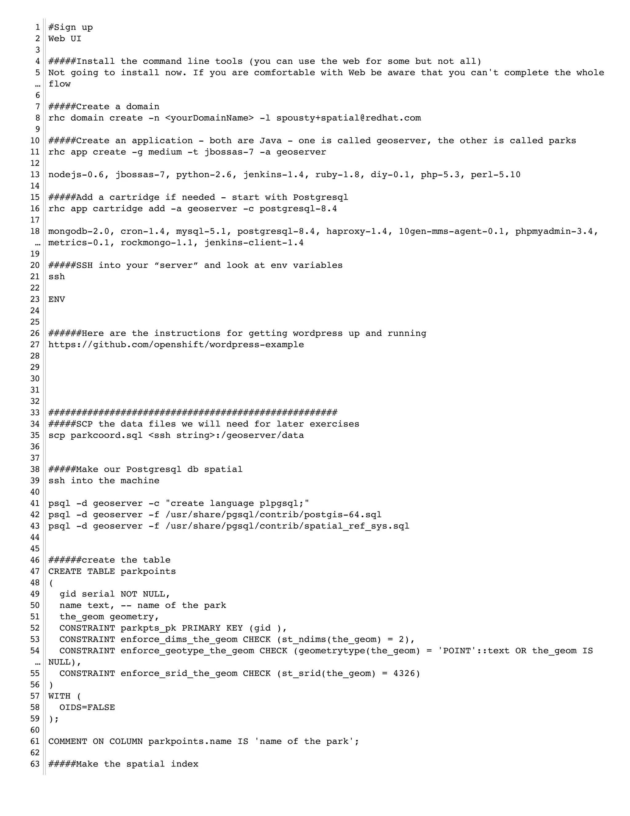
![64 CREATE INDEX parkpoints_spatial_idx ON parkpoints USING gist (the_geom );!
65 !
66 ######back out to the command line to load the data!
67 psql -f geoserver/data/parkcoord.sql parkpoints!
68 !
69 #####Go in and do a query!
70 psql geoserver!
71 SELECT gid, name FROM parkpoints WHERE ST_DWithin('SRID=4326;POINT(-103.8 44.6)',the_geom, 1);!
72 !
73 ####################################################!
74 #####On to MongoDB spatial!
75 !
76 #####create another app - called parks!
77 rhc app create -g medium -t python-2.6 -a parks!
78 !
79 nodejs-0.6, jbossas-7, python-2.6, jenkins-1.4, ruby-1.8, diy-0.1, php-5.3, perl-5.10!
80 !
81 #####Add a cartridge of mongodb!
82 rhc app cartridge add -a parks -c mongodb-2.0!
83 !
84 #####scp our data up to the server!
85 scp parkcoord.json <ssh string>:parks/data/!
86 !
87 #####ssh into the machine!
88 ssh <ssh string>!
89 !
90 #####import into mongo!
91 mongoimport -d parks -c parkpoints --type json --file parks/data/parkcoord.json -h
… $OPENSHIFT_NOSQL_DB_HOST -u admin -p <your mongo password>!
92 !
93 #####open the mongo shell!
94 mongo -u admin -p <your password> $OPENSHIFT_NOSQL_DB_HOST/parks!
95 !
96 #####build the index!
97 db.parkpoints.ensureIndex({"pos":"2d"});!
98 !
99 #####Now some queries!
100 #####simple spatial!
101 db.parkpoints.find({"pos" : { "$near" : [-37, 41]}});!
102 !
103 #####spatial and text query using regex!
104 db.parkpoints.find( { Name : /lincoln/i, pos : { $near : [-37,41] }} );!
105 !
106 #####geonear TODO!
107 db.runCommand({ geoNear : "parkpoints", near : [-37,41], num : 10 });!
108 !
109 !
110 ####################################################!
111 #####Now to load geoserver !
112 #copy the modified war file into the git deployment directory!
113 #need to add the jboss-services.xml into the war file! !
114 #Make changes in your git repo!
115 git add .!
116 git commit -m "adding geoserver"!
117 git push!
118 !
119 #wait for it to deploy!
120 #then hit the url and work away!
121 #let's hook up postgis from before!
122 #preview the layer!
123 !
124 !
125 !
126 !
127 !
128 !](https://image.slidesharecdn.com/scipt-txt-120525161112-phpapp02/75/Script-for-the-geomeetup-presentation-2-2048.jpg)


1. The document provides instructions for setting up applications on OpenShift including creating domains, applications, adding cartridges for databases like Postgresql and MongoDB, and loading spatial data. 2. Steps are outlined for setting up a Java application called GeoServer with Postgresql and spatial data, and a Python application called Parks using MongoDB to store spatial JSON data. 3. Finally it describes deploying a modified GeoServer WAR file on OpenShift to serve spatial layers from the Postgresql data.