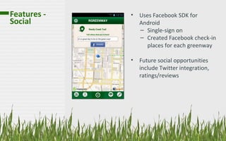
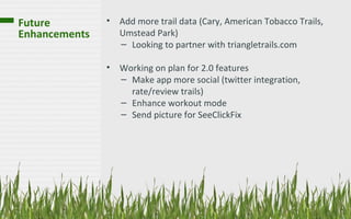
Creating America’s
Smartest Park
RGreenway

          Eric Majewicz
What We’ll   • What is RGreenway?
Cover        • Who are we?
             • Data, Data, Data
             • RGreenway features
               – Trail Map
               – Social
               – Workout Mode
               – Weather
               – SeeClickFix
             • Beta Testing
             • Roadmap / Future Enhancements
What is      •   RGreenway is an app for
RGreenway?       navigating the Raleigh greenway
                 system
             •   Displays trail data including
                 distance, description, and
                 parking lots for each greenway
             •   Shows closest trails to you
                 current location and driving
                 directions
             •   Other features include check-ins
                 on Facebook, workout mode,
                 weather, and SeeClickFix issue
                 reporting
Who are we?
                                                         Lorena Castellanos &
                               Eric Majewicz               David Matthews
                            Software Developer            Graphic Designers


                                                                                Patrick Gravinese
                                                                                  Social Media


            Traci Tillis
      PR / Communications


                                                    Brad Johnson
                                                 Community Relations
Data, Data,   •   City of Raleigh geoportal provides
Data              geospatial for Raleigh landmarks, including
                  greenways
                  – http://maps.raleighnc.gov/geoportal/
                  – KML files include coordinates for
                     greenways, parking, trail descriptions, etc
                     (~1.8MB)
Data, Data,   Issues
Data          1.Data consistency across multiple KML files
              2.Size of files (1.8MB for Raleigh, 2.1MB for Cary)
              3.Performance issues parsing large KML files

              Resolutions
              1.Create an ETL process for cleansing and transforming
              data from multiple sources into a single JSON file
Data, Data,   Resolutions
Data          2. Switched parsers
                 XML parsing using SAXParser   JSON parsing using
                 Jackson
Features –          Map Choices
Trail Map


             Adding Overlays to the Map

                                  •   22,000 coordinates, 232
                                      line strings
                                  •   Performance issues with
                                      adding more overlays
Features –   •   Detect when you are on a
Trail Map        greenway
             •   Displays a list of the closest
                 greenways to your current
                 location
             •   Provides trail name,
                 description, length, parking
                 locations
Features -   •   Uses Facebook SDK for
Social           Android
                 – Single-sign on
                 – Created Facebook check-in
                   places for each greenway

             •   Future social opportunities
                 include Twitter integration,
                 ratings/reviews
Features -   •   Not meant to replace running
Workout          & cycling apps
                 – Displays time and distance
                 – Speech capability using
                    iSpeech SDK

             •   Future opportunities include
                 possible integration with
                 RunKeeper API
Use the Weather Underground API to retrieve weather
Features –            data for the users current location
Weather
Features -
Weather
SeeClickFix is a website used by the City of Raleigh public
Features -     works to allow individuals to report maintenance issues
SeeClickFix
Beta Testing   • Used Zubhium for beta testing
                 – Free tier includes 25 users, unlimited applications
                 – Provides real time crash reports, feedback from
                   users
Future         • Add more trail data (Cary, American Tobacco Trails,
Enhancements     Umstead Park)
                 – Looking to partner with triangletrails.com

               • Working on plan for 2.0 features
                 – Make app more social (twitter integration,
                   rate/review trails)
                 – Enhance workout mode
                 – Send picture for SeeClickFix
Thank
      YOU!
QUESTIONS?
Online
www.rgreenway.com
Twitter
@RgreenwayRal
Facebook
Rgreenway
                    17

RGreenway - TriDroid Presentation

  • 1.
  • 2.
    What We’ll • What is RGreenway? Cover • Who are we? • Data, Data, Data • RGreenway features – Trail Map – Social – Workout Mode – Weather – SeeClickFix • Beta Testing • Roadmap / Future Enhancements
  • 3.
    What is • RGreenway is an app for RGreenway? navigating the Raleigh greenway system • Displays trail data including distance, description, and parking lots for each greenway • Shows closest trails to you current location and driving directions • Other features include check-ins on Facebook, workout mode, weather, and SeeClickFix issue reporting
  • 4.
    Who are we? Lorena Castellanos & Eric Majewicz David Matthews Software Developer Graphic Designers Patrick Gravinese Social Media Traci Tillis PR / Communications Brad Johnson Community Relations
  • 5.
    Data, Data, • City of Raleigh geoportal provides Data geospatial for Raleigh landmarks, including greenways – http://maps.raleighnc.gov/geoportal/ – KML files include coordinates for greenways, parking, trail descriptions, etc (~1.8MB)
  • 6.
    Data, Data, Issues Data 1.Data consistency across multiple KML files 2.Size of files (1.8MB for Raleigh, 2.1MB for Cary) 3.Performance issues parsing large KML files Resolutions 1.Create an ETL process for cleansing and transforming data from multiple sources into a single JSON file
  • 7.
    Data, Data, Resolutions Data 2. Switched parsers XML parsing using SAXParser JSON parsing using Jackson
  • 8.
    Features – Map Choices Trail Map Adding Overlays to the Map • 22,000 coordinates, 232 line strings • Performance issues with adding more overlays
  • 9.
    Features – • Detect when you are on a Trail Map greenway • Displays a list of the closest greenways to your current location • Provides trail name, description, length, parking locations
  • 10.
    Features - • Uses Facebook SDK for Social Android – Single-sign on – Created Facebook check-in places for each greenway • Future social opportunities include Twitter integration, ratings/reviews
  • 11.
    Features - • Not meant to replace running Workout & cycling apps – Displays time and distance – Speech capability using iSpeech SDK • Future opportunities include possible integration with RunKeeper API
  • 12.
    Use the WeatherUnderground API to retrieve weather Features – data for the users current location Weather
  • 13.
  • 14.
    SeeClickFix is awebsite used by the City of Raleigh public Features - works to allow individuals to report maintenance issues SeeClickFix
  • 15.
    Beta Testing • Used Zubhium for beta testing – Free tier includes 25 users, unlimited applications – Provides real time crash reports, feedback from users
  • 16.
    Future • Add more trail data (Cary, American Tobacco Trails, Enhancements Umstead Park) – Looking to partner with triangletrails.com • Working on plan for 2.0 features – Make app more social (twitter integration, rate/review trails) – Enhance workout mode – Send picture for SeeClickFix
  • 17.
    Thank YOU! QUESTIONS? Online www.rgreenway.com Twitter @RgreenwayRal Facebook Rgreenway 17