Remote Sensing &GIS Applications
Remote Sensing & GIS Applications
Directorate
Directorate
Remote Sensing
Remote Sensing
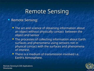
Remote Sensing:
Remote Sensing:
The art and science of obtaining information about
The art and science of obtaining information about
an object without physically contact between the
an object without physically contact between the
object and sensor
object and sensor
The processes of collecting information about Earth
The processes of collecting information about Earth
surfaces and phenomena using sensors not in
surfaces and phenomena using sensors not in
physical contact with the surfaces and phenomena
physical contact with the surfaces and phenomena
of interest.
of interest.
There is a medium of transmission involved i.e.
There is a medium of transmission involved i.e.
Earth’s Atmosphere.
Earth’s Atmosphere.
4.
Remote Sensing &GIS Applications
Remote Sensing & GIS Applications
Directorate
Directorate
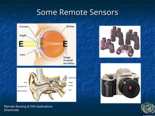
Some Remote Sensors
Some Remote Sensors
5.
Remote Sensing &GIS Applications
Remote Sensing & GIS Applications
Directorate
Directorate
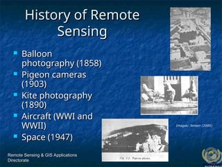
History of Remote
History of Remote
Sensing
Sensing
Balloon
Balloon
photography (1858)
photography (1858)
Pigeon cameras
Pigeon cameras
(1903)
(1903)
Kite photography
Kite photography
(1890)
(1890)
Aircraft (WWI and
Aircraft (WWI and
WWII)
WWII)
Space (1947)
Space (1947)
Images: Jensen (2000)
6.
Remote Sensing &GIS Applications
Remote Sensing & GIS Applications
Directorate
Directorate
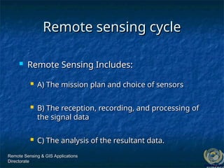
Remote sensing cycle
Remote sensing cycle
Remote Sensing Includes:
Remote Sensing Includes:
A) The mission plan and choice of sensors
A) The mission plan and choice of sensors
B) The reception, recording, and processing of
B) The reception, recording, and processing of
the signal data
the signal data
C) The analysis of the resultant data.
C) The analysis of the resultant data.
7.
Remote Sensing &GIS Applications
Remote Sensing & GIS Applications
Directorate
Directorate
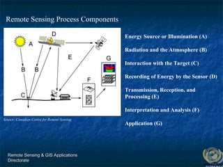
Energy Source or Illumination (A)
Radiation and the Atmosphere (B)
Interaction with the Target (C)
Recording of Energy by the Sensor (D)
Transmission, Reception, and
Processing (E)
Interpretation and Analysis (F)
Application (G)
Source: Canadian Centre for Remote Sensing
Remote Sensing Process Components
Remote Sensing &GIS Applications
Remote Sensing & GIS Applications
Directorate
Directorate
Fundamental term
Fundamental term
All
All remote sensing systems have
remote sensing systems have four types
four types of
of
resolution:
resolution:
Spatial
Spatial
Spectral
Spectral
Temporal
Temporal
Radiometric
Radiometric
Resolution
Resolution
12.
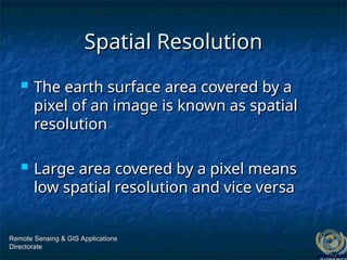
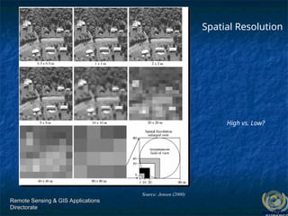
Spatial Resolution
Spatial Resolution
The earth surface area covered by a
The earth surface area covered by a
pixel of an image is known as spatial
pixel of an image is known as spatial
resolution
resolution
Large area covered by a pixel means
Large area covered by a pixel means
low spatial resolution and vice versa
low spatial resolution and vice versa
Remote Sensing & GIS Applications
Remote Sensing & GIS Applications
Directorate
Directorate
13.
Remote Sensing &GIS Applications
Remote Sensing & GIS Applications
Directorate
Directorate
High vs. Low?
Spatial Resolution
Source: Jensen (2000)
14.
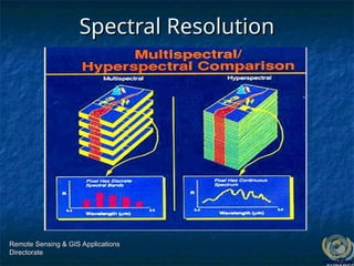
Spectral Resolution
Spectral Resolution
Is the ability to resolve spectral features
Is the ability to resolve spectral features
and bands into their separate
and bands into their separate
components
components
More number of bands in a specified
More number of bands in a specified
bandwidth means higher spectral
bandwidth means higher spectral
resolution and vice versa
resolution and vice versa
Remote Sensing & GIS Applications
Remote Sensing & GIS Applications
Directorate
Directorate
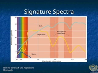
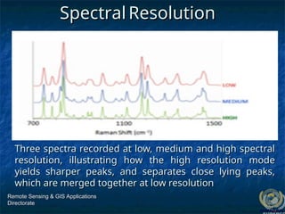
Three spectra recordedat low, medium and high spectral
Three spectra recorded at low, medium and high spectral
resolution, illustrating how the high resolution mode
resolution, illustrating how the high resolution mode
yields sharper peaks, and separates close lying peaks,
yields sharper peaks, and separates close lying peaks,
which are merged together at low resolution
which are merged together at low resolution
Remote Sensing & GIS Applications
Remote Sensing & GIS Applications
Directorate
Directorate
Spectral
Spectral Resolution
Resolution
17.
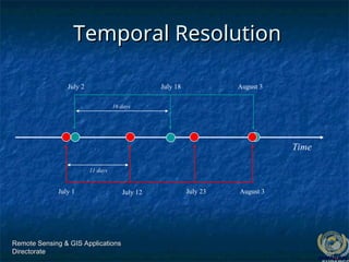
Temporal Resolution
Temporal Resolution
Frequency at which images are recorded/
Frequency at which images are recorded/
captured in a specific place on the earth.
captured in a specific place on the earth.
The more frequently it is captured, the better
The more frequently it is captured, the better
or finer the temporal resolution is said to be
or finer the temporal resolution is said to be
For example, a sensor that captures an image
For example, a sensor that captures an image
of an agriculture land twice a day has better
of an agriculture land twice a day has better
temporal resolution than a sensor that only
temporal resolution than a sensor that only
captures that same image once a week.
captures that same image once a week.
Remote Sensing & GIS Applications
Remote Sensing & GIS Applications
Directorate
Directorate
18.
Remote Sensing &GIS Applications
Remote Sensing & GIS Applications
Directorate
Directorate
Temporal Resolution
Temporal Resolution
Time
July 1 July 12 July 23 August 3
11 days
16 days
July 2 July 18 August 3
19.
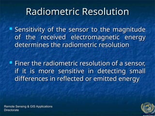
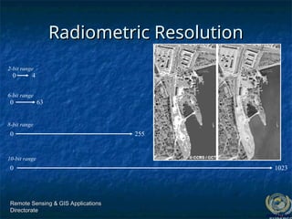
Radiometric Resolution
Radiometric Resolution
Sensitivity of the sensor to the magnitude
Sensitivity of the sensor to the magnitude
of the received electromagnetic energy
of the received electromagnetic energy
determines the radiometric resolution
determines the radiometric resolution
Finer the radiometric resolution of a sensor,
Finer the radiometric resolution of a sensor,
if it is more sensitive in detecting small
if it is more sensitive in detecting small
differences in reflected or emitted energy
differences in reflected or emitted energy
Remote Sensing & GIS Applications
Remote Sensing & GIS Applications
Directorate
Directorate
20.
Remote Sensing &GIS Applications
Remote Sensing & GIS Applications
Directorate
Directorate
Radiometric Resolution
Radiometric Resolution
1023
6-bit range
0 63
8-bit range
0 255
0
10-bit range
2-bit range
0 4
21.
Remote Sensing &GIS Applications
Remote Sensing & GIS Applications
Directorate
Directorate
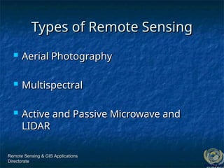
Types of Remote Sensing
Types of Remote Sensing
Aerial Photography
Aerial Photography
Multispectral
Multispectral
Active and Passive Microwave and
Active and Passive Microwave and
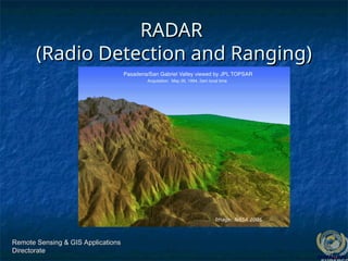
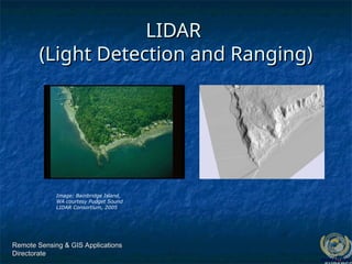
LIDAR
LIDAR
22.
Remote Sensing &GIS Applications
Remote Sensing & GIS Applications
Directorate
Directorate
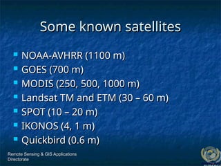
Some known satellites
Some known satellites
NOAA-AVHRR (1100 m)
NOAA-AVHRR (1100 m)
GOES (700 m)
GOES (700 m)
MODIS (250, 500, 1000 m)
MODIS (250, 500, 1000 m)
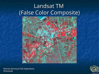
Landsat TM and ETM (30 – 60 m)
Landsat TM and ETM (30 – 60 m)
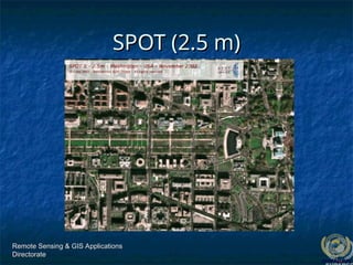
SPOT (10 – 20 m)
SPOT (10 – 20 m)
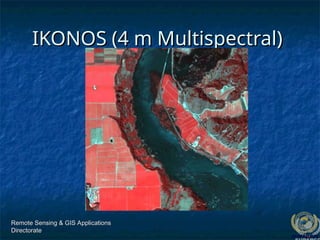
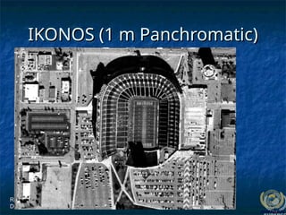
IKONOS (4, 1 m)
IKONOS (4, 1 m)
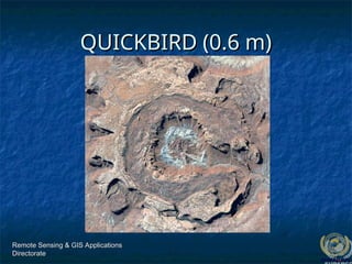
Quickbird (0.6 m)
Quickbird (0.6 m)
23.
Remote Sensing &GIS Applications
Remote Sensing & GIS Applications
Directorate
Directorate
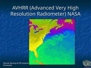
AVHRR (Advanced Very High
AVHRR (Advanced Very High
Resolution Radiometer) NASA
Resolution Radiometer) NASA
Representative Applications of
RepresentativeApplications of
Remote Sensing Conducted by
Remote Sensing Conducted by
SUPARCO
SUPARCO
Remote Sensing & GIS Applications
Remote Sensing & GIS Applications
Directorate
Directorate
35.
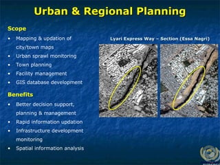
Urban & RegionalPlanning
Urban & Regional Planning
• Mapping & updation of
city/town maps
• Urban sprawl monitoring
• Town planning
• Facility management
• GIS database development
Scope
Lyari Express Way – Section (Essa Nagri)
Lyari Express Way – Section (Essa Nagri)
• Better decision support,
planning & management
• Rapid information updation
• Infrastructure development
monitoring
• Spatial information analysis
Benefits
36.
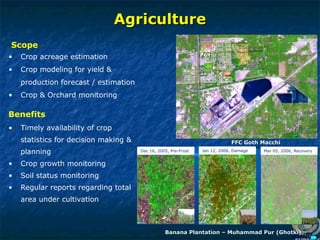
Agriculture
Agriculture
• Crop acreageestimation
• Crop modeling for yield &
production forecast / estimation
• Crop & Orchard monitoring
Scope
• Timely availability of crop
statistics for decision making &
planning
• Crop growth monitoring
• Soil status monitoring
• Regular reports regarding total
area under cultivation
Benefits
Banana Plantation – Muhammad Pur (Ghotki)
Banana Plantation – Muhammad Pur (Ghotki)
FFC Goth Macchi
FFC Goth Macchi
Mar 05, 2006, Recovery
Jan 12, 2006, Damage
Dec 16, 2005, Pre-Frost
37.
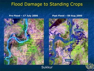
Pre Flood –17 July 2006 Post Flood – 09 Aug 2006
10098 acr
3516 acr
● Phulani
● Goth Lataran
● Ural
● Junno Dhand
● Shahpur
● Godhpur
● Than Lake
● Goth Azizpur
● Goth Raza Mahar
● Phulani
● Goth Lataran
● Ural
● Junno Dhand
● Shahpur
● Godhpur
● Than Lake
● Goth Azizpur
● Goth Raza Mahar
● Muhro Mari
● Darapur
● Kot Shahgarch
● Muhro Mari
● Darapur
● Kot Shahgarch
Flood Damage to Standing Crops
Flood Damage to Standing Crops
Sukkur
38.
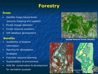
Forestry
Forestry
• Satellite imagebased forest
resource mapping and updation
• Forest change detection
• Forest resource inventory
• GIS database development
Scope
• Availability of baseline
information
• Planning for aforestation
strategies
• Futuristic resource planning
• Sustainability of environment
• Wild life conservation & development
for recreation purpose
Benefits Sarhad Reserve Forest (Ghotki)
Nausharo
Firoz
39.
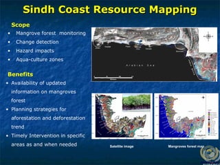
Sindh Coast ResourceMapping
Sindh Coast Resource Mapping
Satellite image Mangroves forest map
• Mangrove forest monitoring
• Change detection
• Hazard impacts
• Aqua-culture zones
Scope
Benefits
• Availability of updated
information on mangroves
forest
• Planning strategies for
aforestation and deforestation
trend
• Timely Intervention in specific
areas as and when needed
40.
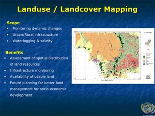
Landuse / LandcoverMapping
Landuse / Landcover Mapping
• Monitoring dynamic changes
• Urban/Rural infrastructure
• Waterlogging & salinity
Scope
• Assessment of spatial distribution
of land resources
• Infrastructure monitoring
• Availability of usable land
• Future planning for better land
management for socio-economic
development
Benefits
Remote Sensing &GIS Applications
Remote Sensing & GIS Applications
Directorate
Directorate
Thanks for patience
Thanks for patience
Editor's Notes
#25 October 23, 2005 Dust storm in Chad at 250 m resolution, MODIS (Moderate Resolution Imaging Spectroradiometer) NASA Moderate Resolution Imaging Spectrometer, 705 km, sun-synchronous orbit, 1-2 day for all of earth, 250 m, 500 m, 1000 m resolution. NASA
#26 30 m resolution and 60 m resolution (thermal), 705 km orbit, 7 bands including thermal infrared, Manhattan, KS. Image, 2000 (USGS-EROS)


![Remote sensing [compatibility mode]](https://cdn.slidesharecdn.com/ss_thumbnails/remotesensingcompatibilitymode-131231034635-phpapp02-thumbnail.jpg?width=640&height=640&fit=bounds)


