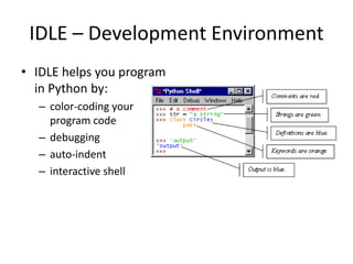
This document provides an introduction to Python, including:
- Python is an open source, high-level programming language that is dynamic typed and includes many standard modules.
- It can be used for GIS tasks like interfacing with ArcGIS and automating geoprocessing workflows.
- Key Python concepts covered include strings, lists, tuples, dictionaries, conditionals, loops, modules, and error handling.
- The document demonstrates how to use the Python IDLE development environment and provides additional resources for learning Python.


![Other Python Objects
• Lists (mutable sets of strings)
– var = [] # create list
– var = [‘one’, 2, ‘three’, ‘banana’]
• Tuples (immutable sets)
– var = (‘one’, 2, ‘three’, ‘banana’)
• Dictionaries (associative arrays or ‘hashes’)
– var = {} # create dictionary
– var = {‘lat’: 40.20547, ‘lon’: -74.76322}
– var[‘lat’] = 40.2054
• Each has its own set of methods](https://image.slidesharecdn.com/pythonfirstday-190827105130/85/Python-first-day-11-320.jpg)
![Lists
• Think of a list as a stack of cards, on which
your information is written
• The information stays in the order you place it
in until you modify that order
• Methods return a string or subset of the list or
modify the list to add or remove components
• Written as var[index], index refers to order
within set (think card number, starting at 0)
• You can step through lists as part of a loop](https://image.slidesharecdn.com/pythonfirstday-190827105130/85/Python-first-day-12-320.jpg)
![List Methods
• Adding to the List
– var[n] = object
• replaces n with object
– var.append(object)
• adds object to the end of the list
• Removing from the List
– var[n] = []
• empties contents of card, but preserves order
– var.remove(n)
• removes card at n
– var.pop(n)
• removes n and returns its value](https://image.slidesharecdn.com/pythonfirstday-190827105130/85/Python-first-day-13-320.jpg)


![Dictionaries
• Dictionaries are sets of key & value pairs
• Allows you to identify values by a descriptive
name instead of order in a list
• Keys are unordered unless explicitly sorted
• Keys are unique:
– var[‘item’] = “apple”
– var[‘item’] = “banana”
– print var[‘item’] prints just banana](https://image.slidesharecdn.com/pythonfirstday-190827105130/85/Python-first-day-16-320.jpg)


![Looping with For
• For allows you to loop over a block of code a set
number of times
• For is great for manipulating lists:
a = ['cat', 'window', 'defenestrate']
for x in a:
print x, len(x)
Results:
cat 3
window 6
defenestrate 12](https://image.slidesharecdn.com/pythonfirstday-190827105130/85/Python-first-day-19-320.jpg)


![Modules
• Modules are accessed using import
– import sys, os # imports two modules
• Modules can have subsets of functions
– os.path is a subset within os
• Modules are then addressed by
modulename.function()
– sys.argv # list of arguments
– filename = os.path.splitext("points.txt")
– filename[1] # equals ".txt"](https://image.slidesharecdn.com/pythonfirstday-190827105130/85/Python-first-day-22-320.jpg)