The document summarizes a research project on developing the Vermillion River in Minnesota into a water trail for recreational activities like canoeing and kayaking. The river flows 38 miles through open fields and forests before reaching Vermillion Falls. The project identified potential access points along the river for canoes and in the gorge area for kayaking. It also explored the process needed to designate the river as an official recreation river. The research was presented to local governments and involved analyzing sites, stakeholder input, best practices, and political considerations to understand the feasibility of a water trail.
The importance of groundwater surface water interaction - a case study on Rio...The Texas Network, LLC
Presented by Ronald T. Green, Ph.D., P.G., F. Paul Bertetti, P.G., and Marques Miller
at the Texas Water Conservation Association Conference in The Woodlands, Texas - March 2014
The importance of groundwater surface water interaction - a case study on Rio...The Texas Network, LLC
Presented by Ronald T. Green, Ph.D., P.G., F. Paul Bertetti, P.G., and Marques Miller
at the Texas Water Conservation Association Conference in The Woodlands, Texas - March 2014
Eyes Over Puget Sound (EOPS) is a news report, and is made available within two days of observation.
http://www.ecy.wa.gov/programs/eap/mar_wat/eops/
We inform on current surface conditions in Puget Sound and links several scales of observation together. The report contains condition summaries, personal flight observations, aerial photographs, en route ferry data, satellite images, and mooring data collected by the Marine Monitoring Unit at Ecology.
Ecology's Marine Monitoring Unit conducts several marine observations with a sampling frequency of minutes to 1 month. We use our routine commute flight between Kenmore Airbase and Olympia to document current marine water conditions by camera and supplement the information with satellite images and en route ferry data between Seattle WA and Victoria BC. This program is an example to optimize monitoring resources. You may subscribe or unsubscribe to the Eyes Over Puget Sound email listserv by going to this link:
http://listserv.wa.gov/cgi-bin/wa?A0=ECOLOGY-EYES-OVER-PUGET-SOUND
Presentation given by John Carlon from River Partners at the Session: "Learning to go with the flow" at the Great Valley Center's Sacramento Valley Forum on October 28, 2009 in Chico, CA.
A Pond Feeding a Lake Feeding an Ocean: A DPLA Contributing Institution's Pe...Chelcie Rowell
Chelcie Juliet Rowell will share Wake Forest University's perspective as a contributing institution to the DPLA via the North Carolina Digital Heritage Center Service Hub. Like many institutions, we are grappling with how to represent archival materials at the item-level as the DPLA data model requires. In addition, we are using participation in the DPLA as an opportunity to clean up our metadata. Borrowing the principle of iterative and incremental development from the agile software development community, we treat each monthly harvest as a four-week development cycle during which we identify and implement small but meaningful improvements to our metadata. A presentation at the Society of North Carolina Archivists 2014 Annual Conference.
The final report of a pilot program with TVA, Southeast Watershed Forum and the Wilson County Water cooperative group (WCW).
Smart Growth and Planning allow best use of current assets and strategic planning for future resources.
Green infrastructure, conservation, environmental preservation and restoration combine with quality of life and good business.
Presentation by Kathleen Jackson, director of the Texas Water Development Board, at the 2018 Gulf Coast Water Conservation Symposium in Houston, Texas.
Where Land and Water Meet - Mike Swezy from Marin Municipal Water DistrictAnnie Burke
On March 17, 2016 (St Patty's Day!) we convened a Gathering with 4 water agencies to talk about land stewardship, drought, and partnerships. More info over at: http://openspacecouncil.org/community-events/gatherings/
The him! team were out exploring the latest in foodservice and came across this gem! The first Cafe Nespresso in the UK can be found on 100 Cheapside and serves countless types of coffees as well as hot and cold food-to-go. Take a look at a few photos we took on our visit.
Join Kevin as he shares techniques for deploying changes to Salesforce, from quick fixes to well-developed ALM strategies featuring continuous integration with automated deployments. Even in the world of No Software, engineers still need to collaborate in order to get the most out of the platform. Reflecting on his experiences over a year of speaking with developers and admins, Kevin will explain how you can work together effectively and make changes to your Salesforce organizations safely.
Merchandise, store and financial planning with TargettaMärt Parker
Targetta offers affordable merchandise, store and financial planning tool for retail companies. Our software is designed to improve the accountability and performance in small or large organiztions.
The Blueprint Jordan River visioning process was completed in December of 2008. Close to 3,000 residents and stakeholder participated in drafting a public vision for the river.
NJ Future Sandy One Year Later Design Hensold Oct 29 2013New Jersey Future
Design ideas for increasing resiliency among New Jersey coastal towns, presented by one of the finalists in the HUD Rebuild by Design competition. Part of the Sandy One Year Later conference Oct. 29, 2013, at Monmouth University, co-presented by the Union of Concerned Scientists and the Recovery Fund as well as New Jersey Future and Monmouth University.
Making the case for valley scale restorationLeif Embertson
The fluvial landscape of most watersheds within North America fundamentally changed during European settlement. Through impacts related to natural resource extraction, navigation, transportation, and flood control, all as part of “Manifest Destiny”, the conditions and processes that defined fluvial ecosystems were altered. Rivers are still adjusting to historical impacts that may have occurred more than 100 years ago. Specific impacts in many watersheds include timber harvest, splash damming, placer mining, removal of large wood and logjams, draining of wetlands, channel confinement by highways, railroads, and levees, channel straightening, channel training, damming, urbanization, water quality pollution, flood control, and many more.
Due to the pervasiveness and scale of these impacts, restoration must consider efforts across the entire valley width and be of significant magnitude to address the impacts if we are to succeed with the recovery of the system. Restoration at the valley scale is a daunting effort to many organizations, local, state, and federal governments, tribes and co-managers requiring coordination and collaboration across physical and political boundaries. Confounding restoration efforts, resource managers and practitioners often need to educate communities and regulators due to misperceptions that present day conditions represent good reference conditions for fluvial systems. Common barriers to valley scale restoration include;
• Historical misconceptions of what a river is
• Landowner and community willingness
• Mitigating encroachment into the valley by development relocation or adaptation of existing infrastructure
• Regulatory and land use policies obstructing restoration
• Assessment and implementation costs
Examples of watershed scale impacts on the Nooksack, Skagit, Elwha, and Greys Rivers and their accompanying effects will be described in this session’s presentations. These examples of valley scale restoration illustrate some common barriers and most importantly, solutions for establishing and managing fluvial corridors that can achieve meaningful recovery, reverse impacts from previous generations and guide us down a more sustainable path into the future.
1. recreate educate protect
|
z
s
[
l
m
h
u
Vermillion River Water Trail
FVRWT
Friends of the Vermillion
River Water Trail
Center for Urban and Regional Affairs
Community Assistance Program
University of Minnesota, Summer 2005
Graduate Research by
Christopher Ochs
MLA and MURP Candidate
Board # of 20
o
I n v e n t o r y A n A l y s I s
r e g I o n A l - d A k o t A C o u n t y /
v e r m I l l I o n W A t e r s h e d
The Vermillion River Watershed is approxiamtely 372 square miles lying mostly within
Dakota County and partially within Scott County of the seven county metropolitan area
of the Twin Cities. The river flows 38 miles between its start and Vermillion Falls at
Vermillion Falls Park in Hastings, MN. The river meanders through open grassland and
agricultural fields until it reaches the falls at which point it rapidly descends through
the gorge falling approximately 90 feet. Portions of the river are designated as trout
streams offering rare trout fishing opportunites within a greater metropolitan area. De-
spite the areas of high quality trout habitat, pollution remains a critical issue. Urbaniza-
tion of agricultural land places development pressure on the river and its unique habitats.
Recreation on the river includes hunting, fishing, inner-tubing, birdwatching, canoeing, and
kayaking in the gorge. Preserving and enhancing the existing conditions of the Vermillion
River for passive recreation such as a water trail would greatly benefit the river as well
as the surrounding communities and a growing population of recreational users.
recreate educate protect
|
z
s
[
l
m
h
u
Vermillion River Water Trail
FVRWT
Friends of the Vermillion
River Water Trail
Center for Urban and Regional Affairs
Community Assistance Program
University of Minnesota, Summer 2005
Graduate Research by
Christopher Ochs
MLA and MURP Candidate
Board # of 20
o
I n v e n t o r y A n A l y s I s
l o c A l - H A s t I n g s g o r g e
Series of rapids attract a fleet of kayakers. Best source of rapids for kayaking within 2 hours
of the metropolitan area.
Classified as Class II and III rapids by American Whitewater kayaking organization.
www.americanwhitewater.org
Up to 40 kayakers per week recreate when flows exceed 80 cfs. Kayak-able as low as 40
cfs.
Seven holes in the stretch where kayakers exercise their skills.
Difficult and dangerous to descend gorge, but it is done by kayakers and the curious alike.
61
Vermillion Falls Park
Old Mill
Park
1
2 3
Donut hole
S-bendWarm-up wave
E. 18th Street
Reach
1. 585 ft
2. 1420 ft
3. 1364 ft
(3369'Approx. Dist)
Falls
Railroad
Triple Drop
Rope ledge
Old Mill Ruin,
take out
Pool,2nd
put-in
Lower ledge
Vermillion Falls
Fast water at Donut hole Middle of S-bend Bottom of S-bend Easing out of Lower ledge
Upstream at Old Mill - takeout
Goat path at Old Mill
Slope degradation on goat paths
Gorge wall and steep slope near falls
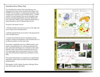
Vermillion River Water Trail
The Vermillion River Water Trail research project was
initiated by the Friends of the Vermillion River Water Trail
(FVRWT) for the purpose of exploring the feasibility of de-
veloping water recreation on the Vermillion River. FVRWT
consists of several members from private and public orga-
nizations including Rapids Riders, American Whitewater,
City of Hastings, Dakota County, Minnesota Department of
Natural Resources, and US National Parks Service.
The goals of the project were to:
1. Identify potential canoe trail access sites on the upper and
lower reaches of the Vermillion River;
2. Identify potential kayak access points in the gorge portion
of the Vermillion River;
3. Explore and develop the process of legislative action
required to change the designation of the Vermillion River to
an official recreation river for water trails.
Site analysis, stakeholder interviews, BMP research, water
quality, surrounding land uses, existing and potential haz-
ards, and political challenges were evaluated to fully under-
stand the context and sentiments associated with the river.
The twenty page report was presented to the City of Hast-
ings’ Park and Recreation Department and Dakota County
Parks.
This project demonstrates my experience in a regional plan-
ning project and the skills associated with the development
and presentation.
Photography, ArcGIS, Adobe- Illustrator, InDesign, Photo-
shop, and Acrobat, and MS Office