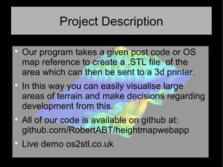
OS2STL
Project Description

Our program takes a given post code or OS
map reference to create a .STL file of the
area which can then be sent to a 3d printer.

In this way you can easily visualise large
areas of terrain and make decisions regarding
development from this.

All of our code is available on github at:
github.com/RobertABT/heightmapwebapp

Live demo os2stl.co.uk
The Team

Robert Buchan-Terrey

Ferdia McKeogh

Linus Kirkwood
Why?

A year ago I was looking around at 3d printing
areas of land to help plan a radio broadband
link which required line of sight.

Scale models of this sort could be used by
anyone from model hobbyists, to tabletop
gamers to property developers.
Existing solutions

There are some existing tools and methods to
create .stl files from given areas but they are
either expensive and closed source, fiddly or
very difficult to implement.

(For loading terrain data into Openfoam there
is an 18 page pdf document!)
The data

Our project uses Ordnance Survey Terrain50
data files (which are downloadable from their
website) to generate the .stl files

http://www.ordnancesurvey.co.uk/business-
and-government/products/terrain-50.html

It also uses an open source API to convert
post codes to OS grid references.
http://www.nearby.org.uk/api/
The code

The web app uses a mix of Python (which
does the core processing) along with
Javascript and HTML (to display the webpage
and the .STL file preview)

os2stl

  • 1.
  • 2.
    Project Description  Our programtakes a given post code or OS map reference to create a .STL file of the area which can then be sent to a 3d printer.  In this way you can easily visualise large areas of terrain and make decisions regarding development from this.  All of our code is available on github at: github.com/RobertABT/heightmapwebapp  Live demo os2stl.co.uk
  • 3.
  • 4.
    Why?  A year agoI was looking around at 3d printing areas of land to help plan a radio broadband link which required line of sight.  Scale models of this sort could be used by anyone from model hobbyists, to tabletop gamers to property developers.
  • 5.
    Existing solutions  There aresome existing tools and methods to create .stl files from given areas but they are either expensive and closed source, fiddly or very difficult to implement.  (For loading terrain data into Openfoam there is an 18 page pdf document!)
  • 6.
    The data  Our projectuses Ordnance Survey Terrain50 data files (which are downloadable from their website) to generate the .stl files  http://www.ordnancesurvey.co.uk/business- and-government/products/terrain-50.html  It also uses an open source API to convert post codes to OS grid references. http://www.nearby.org.uk/api/
  • 7.
    The code  The webapp uses a mix of Python (which does the core processing) along with Javascript and HTML (to display the webpage and the .STL file preview)