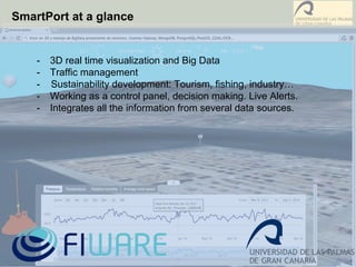
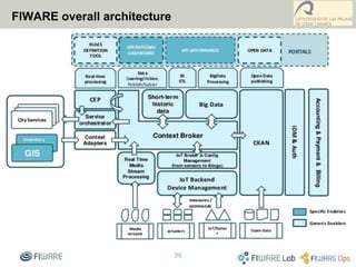
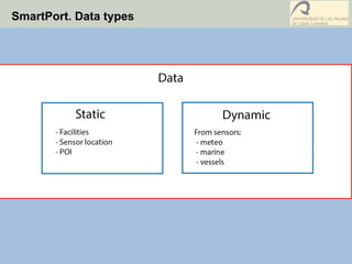
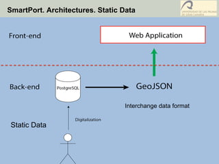
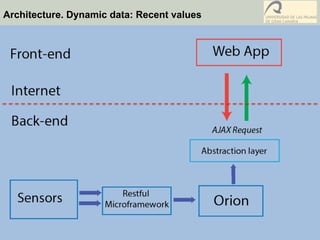
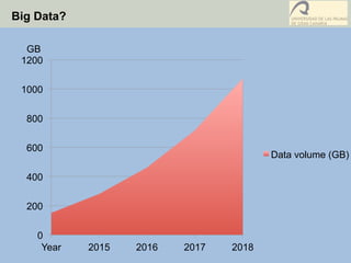
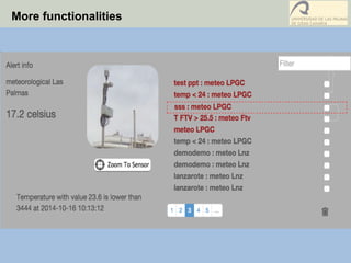
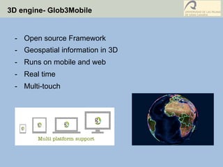
Managing and 3D Visualization of Real-time Big
Geo-referenced Data from Las Palmas Port through
a Flexible Open Source Computer Architecture
José P. Suárez, Agustín Trujillo, Conrado Domínguez, José M. Santana and Pablo Fernández
Index
1.  Introduction and Motivation
2.  Data types in SmartPort. Sensors and static data
3.  Architectures for Big Data
4.  Glob3Mobile for 3D visualization
5.  SmartPort in action
Canary islands, a nice place to live and do research
A warm climate all year
benefits co-working/
collaboration and help
new fresh ideas and
creativity
Geography of Canary Islands
1583 kilometer of marine coast
Heavy marine interaction with economy
Ecological value: Gran Canaria Reserve of the Biosphere
Gran Canaria has 33 protected natural areas. Nearly 43% of the land area of the
island and an extra area of marine coverage.
Ship in Gran Canaria: Oil disaster
Recent disaster in
Gran Canaria,
derived from a
chain of bad
decisions
What is FIWARE?
SmartPort at a glance
-  3D real time visualization and Big Data
-  Traffic management
- Sustainability development: Tourism, fishing, industry…
-  Working as a control panel, decision making. Live Alerts.
-  Integrates all the information from several data sources.
FIWARE overall architecture
SmartPort. Data types
SmartPort. Architectures. Static Data
Static Data
Interchange data format
Architecture. Dynamic data: Recent values
Big Data?
0
200
400
600
800
1000
1200
Year 2015 2016 2017 2018
GB
Data volume (GB)
Big Data. The problem
Time MySQL PostgreSQL Hadoop
All meteo data 3,03 4,99 59,51
An element by
date
1,55 2,53 74,83
Big Data. The solution
Time MySQL PostgreSQL Hadoop
Opimized
All meteo data 3,03 4,99 4,76
One attribute
orderer by
date
1,55 2,53 5,98
Big Data. Data mining
More functionalities
3D engine- Glob3Mobile
-  Open source Framework
-  Geospatial information in 3D
-  Runs on mobile and web
-  Real time
-  Multi-touch
SmartPort in Action
Other projects ULPGC - OpenData
Thank you!!
pablo.fernandez@ulpgc.es
PHD. JOSE PABLO SUÁREZ RIVERO
CIO ULPGC
PHD. AGUSTÍN TRUJILLO PINO
COMPUTING TEACHER
PABLO FERNÁNDEZ MONIZ
GIS SPECIALIST
JAISIEL SANTANA ALMEIDA
COMPUTER ENGINEER
SEBASTIÁN ORTEGA TRUJILLO
COMPUTER ENGINEER
ALEJANDRO SÁNCHEZ MEDINA
COMPUTER ENGINEER
JOSE MIGUEL SANTANA NÚÑEZ
COMPUTER ENGINEER
CONRADO DOMÍNGUEZ TRUJILLO
ULPGC MANAGER

Presentacion gistam2001504v2

  • 1.
    Managing and 3DVisualization of Real-time Big Geo-referenced Data from Las Palmas Port through a Flexible Open Source Computer Architecture José P. Suárez, Agustín Trujillo, Conrado Domínguez, José M. Santana and Pablo Fernández
  • 2.
    Index 1.  Introduction andMotivation 2.  Data types in SmartPort. Sensors and static data 3.  Architectures for Big Data 4.  Glob3Mobile for 3D visualization 5.  SmartPort in action
  • 3.
    Canary islands, anice place to live and do research A warm climate all year benefits co-working/ collaboration and help new fresh ideas and creativity
  • 4.
    Geography of CanaryIslands 1583 kilometer of marine coast Heavy marine interaction with economy
  • 5.
    Ecological value: GranCanaria Reserve of the Biosphere Gran Canaria has 33 protected natural areas. Nearly 43% of the land area of the island and an extra area of marine coverage.
  • 6.
    Ship in GranCanaria: Oil disaster Recent disaster in Gran Canaria, derived from a chain of bad decisions
  • 7.
  • 8.
    SmartPort at aglance -  3D real time visualization and Big Data -  Traffic management - Sustainability development: Tourism, fishing, industry… -  Working as a control panel, decision making. Live Alerts. -  Integrates all the information from several data sources.
  • 9.
  • 10.
  • 11.
    SmartPort. Architectures. StaticData Static Data Interchange data format
  • 12.
  • 13.
    Big Data? 0 200 400 600 800 1000 1200 Year 20152016 2017 2018 GB Data volume (GB)
  • 14.
    Big Data. Theproblem Time MySQL PostgreSQL Hadoop All meteo data 3,03 4,99 59,51 An element by date 1,55 2,53 74,83
  • 15.
    Big Data. Thesolution
  • 16.
    Big Data. Thesolution Time MySQL PostgreSQL Hadoop Opimized All meteo data 3,03 4,99 4,76 One attribute orderer by date 1,55 2,53 5,98
  • 17.
  • 18.
  • 19.
    3D engine- Glob3Mobile - Open source Framework -  Geospatial information in 3D -  Runs on mobile and web -  Real time -  Multi-touch
  • 20.
  • 21.
  • 22.
    Thank you!! pablo.fernandez@ulpgc.es PHD. JOSEPABLO SUÁREZ RIVERO CIO ULPGC PHD. AGUSTÍN TRUJILLO PINO COMPUTING TEACHER PABLO FERNÁNDEZ MONIZ GIS SPECIALIST JAISIEL SANTANA ALMEIDA COMPUTER ENGINEER SEBASTIÁN ORTEGA TRUJILLO COMPUTER ENGINEER ALEJANDRO SÁNCHEZ MEDINA COMPUTER ENGINEER JOSE MIGUEL SANTANA NÚÑEZ COMPUTER ENGINEER CONRADO DOMÍNGUEZ TRUJILLO ULPGC MANAGER