1. The Indian Monsoon!
L/O:
To understand what the effects of a Monsoon are for people
and the environment
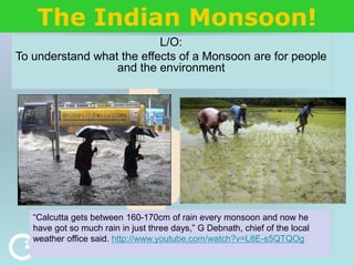
“Calcutta gets between 160-170cm of rain every monsoon and now he
have got so much rain in just three days,” G Debnath, chief of the local
weather office said. http://www.youtube.com/watch?v=L8E-s5QTQOg
2. The Indian Monsoon!
L/O:
To understand what the what effects of a Monsoon are for
people and the environment
“Calcutta gets between 160-170cm of rain every monsoon and now he
have got so much rain in just three days,” G Debnath, chief of the local
weather office said.
I fully
understand
the LO
I’m not really
sure what the
LO is about
3. What questions do you have for these boys? Write at
least 3 questions down in your books
What do you think might be happening in this
photo? Write an idea in your book
4. • Use CIA World Factbook and write down 3
interesting facts about India’s:
– People
– Economy
– Geography
Starter!
5.
6. Use the clues to help you label the regions in blue onto
map 2. draw something to represent each feature, then
use the text to annotate your map
Himalayas High mountains reaching across northern India and bordering countries. The
highest mountain in India is K2 in the Karakorum Range. India has the largest
area of snow and glaciers in the world, covering 248,000km .
Deccan
Plateau
An area of raised land occupying much of central India. It is bordered by two hill
ranges: the Western and Eastern Ghats.
Western
Ghats
Hills that are often called the ‘backbone of India’. They stretch from the tip of the
country for 1000km along the western coast.
Thar Desert Also known as ‘The Great Indian Desert’, it forms the border between India and
south eastern Pakistan.
Low-lying
areas
These are mainly near to the coast, which is 5,656km long. In the hot season
(April to May), temperatures can reach over 40°C.
River
Ganges
This holy river rises in the Himalayas and flows into the Bay of Bengal.
Bay of
Bengal
A bay that borders India, Bangladesh, Myanmar, and northern Thailand.
It has a triangular shape and has an area of 2,172,000km .
8. Finally…use Google Earth to locate
and name the following…
• Where are all India’s people?
• Label your map with the 4 main cities;
– New Delhi (the capital city)
– Bangalore
– Mumbai (Previously Bombay)
– Kolkata (Previously Calcutta)
9. • During the summer months
• Dry season and a wet season
• a time when there is a lot of rain,
sometimes it causes flooding
• There are good things and bad things that
can come from the monsoon
What is a monsoon and how do they develop?
10. What is a monsoon and how do they develop?
• India’s monsoon lasts from June to October.
• Cherrapunji, situated high up in north east India, is one
of the wettest places in the world with 11,000mm of
rainfall!
• There are two distinct seasons dry and wet. The
seasons change when the wind changes.
• When the land is warmer than the sea, air is constantly
rising on land creating a low pressure.
• From April, heat builds over the land and rising of less
dense air (as the land warms faster) form areas of low
pressure, over North India and the Himalayas.
11. • Over the oceans the air is cooler so to maintain the
energy balance the air starts flowing from the oceans
(high pressure) to the land (low pressure) bringing in the
moisture rich southwest winds across southern Asia - the
‘wet’ phase which starts around June.
• When the monsoon rains have cooled the land so much
that the air is warmer out to sea, the wind changes
direction and become a north-easterly and the rains
retreat and end around the end of October–the dry
phase.
What is a monsoon and how do they develop?
12. The South Asian Monsoon
Deccan
Plateau
Indian
Ocean
Central Asia
Tibetan
Plateau
Himalayas
Moist air drawn north Hot ground
Hot air rising
(Low Pressure)
13. The South Asian Monsoon
Deccan
Plateau
Indian
Ocean
Central Asia
Tibetan
Plateau
Himalayas
Moist air drawn north Hot ground
Hot air rising
(Low Pressure)
Air rises,cools,
clouds form
Rain!
14. The South Asian Monsoon
Deccan
Plateau
Indian
Ocean
Central Asia
Tibetan
Plateau
Himalayas
Moist air drawn north Hot ground
Hot air rising
(Low Pressure)
Air rises,cools,
clouds form
Rain!
16. The South Asian Monsoon: Winter
Deccan
Plateau
Indian
Ocean
Central Asia
Tibetan
Plateau
Himalayas
Cold, dry air builds up
Very Cold Ground
Air chilled and
sinks ( High
Pressure)
17. The South Asian Monsoon: Winter
Deccan
Plateau
Indian
Ocean
Central Asia
Tibetan
Plateau
Himalayas
Dry air spills over
Himalayas
Very Cold Ground
Air chilled and
sinks ( High
Pressure)
18. The South Asian Monsoon: Winter
Deccan
Plateau
Indian
Ocean
Central Asia
Tibetan
Plateau
Himalayas
Dry air spills over
Himalayas
Very Cold Ground
Air chilled and
sinks ( High
Pressure)
Dry Air= no clouds=
NO RAIN
20. Arrival of the Monsoon
Nishantapur, Bangladesh
National Geographic Student Atlas
21. Arrival of the Monsoon
Turag River, Bangladesh (National Geographic)
22. Think about what the effects of the monsoon are
on people, think...pair...share
23.
24. What effect does the Monsoon
have?
• Good Monsoon = good harvest
Madhya Pradesh, India, 1988 (National Geographic)
25. What effect does the Monsoon
have?
• Gujarat 2005
• Bangladesh 2004
Dakar, Bangladesh ( National Geographic)
26. Unusual Signs!
• In the northern
Indian city of
Lucknow - mouse
perches on a frog in
“waist-deep” flood
water
• A small sign of the
early arrival of
annual summer
monsoon rains.
National
Geographic.com
27.
28. Are there any good things about
the Monsoon?
• Mainly positive =
• Mainly negative =
• A bit of both =