Presentation from Deschutes Land Trust's Nature Night series. Maret Pajutee talks about fire and fire recovery after 2012's Pole Creek Fire near Sisters, Oregon. Maret is the District Ecologist for the Sisters Ranger District in Deschutes National Forest.
This document discusses wildfires, including their causes, types, and effects. Wildfires are fires that occur in areas with combustible vegetation outside of cities or towns. They are fueled by elements like heat, oxygen, and materials like brush, trees, and grass. Wildfires can be classified by the type of vegetation they burn and how they spread, such as on the ground, through brush, or through tree canopies. Wildfires can be caused by natural events like lightning or volcanic eruptions, or by human factors like sparks from machinery. They negatively impact the environment by destroying habitats, soils, plants, and animals, and can threaten human lives and property. Methods to stop wildfires include traditional techniques like using
The document discusses several issues related to environmental degradation including increasing greenhouse gases, deforestation, and high waste production which can lead to problems like earthquakes, floods, and forest fires. It also mentions some solutions such as recycling, saving energy through more efficient light bulbs, planting trees, and reducing marine litter.
Deforestation involves the removal of forests, with half of the world's forests already gone. The main causes are expansion of agriculture and cattle ranching, firewood collection, and timber harvesting. Potential solutions include reforestation, legislation, wildlife sanctuaries, commercial forest plantations, and water management to help mitigate the effects of deforestation such as climate change and soil erosion.
Carbon Cycles In Western Forests Saf 5 1 2009Mike Ryan
The document discusses carbon cycling in western forests. It finds that forests play a large role in offsetting carbon emissions through sequestration. Disturbances like fires and outbreaks do not necessarily cause long-term carbon loss if the forest regenerates. The timing and landscape perspective of forest carbon storage is important to consider. Tropical deforestation is currently a large source of carbon emissions comparable to US fossil fuel emissions each year.
Carbon Storage And Carbon Credits For Forest Management The Good, The Bad, An...Mike Ryan
This document discusses carbon storage and carbon credits for forest management. It covers the complexities in accurately accounting for forest carbon over different scales of space and time given natural disturbances. While retaining existing forests and planting new forests are good options, other forest management activities like thinning may not provide long-term carbon benefits due to emissions and uncertainty around leakage. International deforestation also emits a significant amount of carbon annually.
The document summarizes the Crowsnest Fires that occurred in Alberta, Canada in August 2003. It began as a small fire but grew rapidly to 6km long and 50m high, producing as much energy as an atomic blast every 30 minutes. While some local businesses were unaffected, tourism suffered and salvage efforts depended on the level of damage. The fire burned 20,000 hectares of forest but created new ecological diversity and growth. Local residents had to evacuate with little notice, only able to gather some of their belongings as the fire approached.
Tree rings are annual because patterns in tree-ring widths can be matched among several trees, allowing identification of the exact year each ring was formed. This principle of cross-dating works by comparing ring patterns to neighboring rings and among multiple trees. While complications can occur like micro-rings, missing rings, or false rings, tree-ring dating is possible for tree species that are sensitive to environmental conditions and produce rings that vary in width from year to year.
Throughout February and March 2009, devastating bushfires occurred in Victoria, Australia, destroying lives, property, and landscapes. As communities rebuild, reestablishing gardens will play an important role in recovery by providing spaces for reflection, contemplation, and restoring mental health. However, the extreme heat of the fires severely damaged soils, coating them with a thick layer of ash that repels water and contaminants. Reestablishing gardens will be difficult until soils recover and ash disperses, but doing so will help communities reconnect with the land as an important part of healing.
The document is a newsletter from the Kern-Kaweah Chapter of the Sierra Club for November/December 2010. It contains three main articles: 1) Residents in the community of Weldon oppose a proposed 300-acre solar development project due to concerns about impacts to farmland, flooding risks, and dust. 2) A court ruling requires the city of Tulare to redo its environmental report for a proposed sports complex project, delaying the project. 3) The newsletter encourages members to vote in upcoming elections and provides candidate statements from people running for the chapter's executive committee.
Water, air, soil, forests, and oil are the five natural resources discussed in the document. These resources are essential to life and the economy but must be managed carefully to ensure their continued availability. Protecting and sustainably using natural resources like these is important for current and future generations.
REDD+ in Ethiopian silvipastoral systems: effects on vegetation, livelihoods ...CIFOR-ICRAF
Presented by Maria Johansson (Stockholm Uni.) on 28 August 2019 at "Fire Trends in Ethiopia in the Context of REDD+ and FLR Investments" Workshop, Addis Ababa, Ethiopia.
I've been asked to give a presentation at a workshop to be held in Alberta in March. The workshop will revolve mainly around the use of tree rings and other natural 'proxy' records to water issues in the Canadian Prairie provinces.
I'll be presenting material drawn from the last chapter of my doctoral dissertation, and will talk about the strengths and limitations of tree-ring records as indicators of past drought. The audience will include between 50 and 100 water managers from the region, and for many of them, the workshop will be their first exposure to tree rings and other forms of paleoclimatology. I think it will be in their best interest (and mine) that the scientific presentations focus more on big-picture ideas and less on technical details and methodology.
With an eye towards getting my point across more effectively, I've worked up a set of slides in the 'Presentation Zen' style. I've included more photos than I have in previous presentations, and have also tried to swap out complex journal-style diagrams and replace them with simpler graphics.
I'm excited (and a little nervous) to see how the presentation is received - I imagine its style will be quite different from the other talks in the workshop. I've posted the slides at Slideshare.net, and would appreciate any comments or suggestions - the workshop is not for another six weeks, so I have plenty of time left to tweak or change my plans.
A random wildfire in Crowsnest, Alberta grew out of control on August 21, 2003, burning over 20,000 hectares of forest land and forcing nearby residents to evacuate their homes. The fire had the energy equivalent of an atomic explosion every 30 minutes. While the timber industry and tourism businesses were negatively affected, local services like dry cleaners and restaurants were able to maintain steady business. Spray Lake Sawmills benefited from the fire by obtaining salvage rights to burnt lumber, allowing them to utilize a significant amount in their operations.
A wildfire in Crowsnest, Alberta grew rapidly, transforming into a giant fire with flames reaching 50 meters high and releasing energy equivalent to an atomic explosion every 30 minutes. As authorities evacuated households, Elaine Hruby watched helplessly from a safe distance as the intense, magnet-like flames destroyed her town of Hillcrest. While the fire burned over 20,000 hectares and impacted local industries, some ecological benefits emerged as 28% of burnt lumber was recycled, new plant growth sprung up, and biodiversity increased in the affected areas.
This document discusses research on the impacts of fire on rangeland hydrology and erosion processes in the western United States. The goals are to improve understanding of disturbance impacts, develop tools to predict effects on hydrologic and erosion processes, and provide guidance to land managers. Field research was conducted from 1996-2017 on sites dominated by sagebrush, pinyon-juniper, and western juniper in Idaho, Utah, Nevada and other states. Results show that fire increases connectivity of overland flow paths and sediment delivery. Recovery occurs as vegetation reduces bare ground and connectivity over multiple growing seasons.
This is a powerpoint that I had to edit and redo as part of an ICT course I am taking. I did not research the information in it, I only edited what information was already there and added a few pictures.
This document discusses global warming and its causes and effects. It states that carbon dioxide emissions cause global warming, leading to problems like droughts, floods, melting ice caps, rising sea temperatures and sea levels, and stronger hurricanes and tornadoes. The document suggests using public transport, efficient energy use, recycling, and reducing our carbon footprint to help prevent the problems caused by global warming.
Mackenzie Nelsen, a junior at Watauga High School, collected tree core samples from high and low elevation areas to analyze how climate change may affect high altitude carbon sequestration. She found that trees at elevations over 3,000 feet showed significantly more growth variation from 1990-2013 compared to low elevation trees. This suggests climate change will have a greater impact on mountain ecosystems. Higher CO2 levels may boost high elevation tree growth through fertilization but also make them more vulnerable to climate extremes.
ICLR Friday Forum: Living with fire in Canada's forests (May 15, 2020)glennmcgillivray
The prevalence of wildfire disasters across Canada over the past two decades such as occurred in Kelowna, BC in 2003 and Fort McMurray, AB in 2016 has prompted a continuing search for solutions to address the wildland-urban interface or intermix (WUI) problem in the country. While it is theoretically possible to exclude human-caused wildfire occurrences, the complete exclusion of unwanted fires is not likely given even the most highly sophisticated fire prevention, detection and suppression programs. Professor Dougal Drysdale (2011) – Introduction to Fire Dynamics has stated that "Further major advances in combating wildfire are unlikely to be achieved simply by continued application of traditional methods. What is required is a more fundamental approach which can be applied at the design stage ... Such an approach requires a detailed understanding of fire behaviour." The concept of forest conflagration control through managing vegetation or fuels is discussed on the basis that the elimination of ignition risk in the WUI is not foreseen as feasible and that addressing the “fuel” component of the fire environment offers the only viable course of action possible given that neither weather or topography can be modified. The aim of fuels management is to reduce a fire’s intensity and spread rate so that containment by conventional suppression forces can be effective. In this regard, the creation of “aspen fuel breaks” offers one of the best chances for success.
Dr. Marty Alexander is a registered professional forester who began his wildland fire career in 1972 as a hotshot crew member. He retired from full-time work in late 2010 as a senior fire behaviour research officer after nearly 35 years with the Canadian Forest Service. His primary research and technology transfer interests have principally focused on the practical application of empirical fire behaviour knowledge to community protection and firefighter safety concerns. Marty has continued this line of emphasis in semi-retirement.
A seasonal wildfire in Crowsnest Pass abruptly changed direction, growing into a 6-km wall of flames up to 50 m high with the energy of an atomic explosion every 30 minutes, forcing emergency evacuations. Over 20,000 hectares of forest were burned, hardest hit were the timber industry, local businesses, and tourism. While salvage efforts aim to recover burnt lumber, forest fires can create ecological diversity and undergrowth.
The document discusses various topics related to climate change including:
1. Different biomes and their typical climates such as tundra, taiga, temperate grasslands, and tropical rainforests.
2. Causes of climate change like the greenhouse effect, El Nino, and greenhouse gases such as carbon dioxide, methane, and nitrous oxide.
3. Impacts of climate change like rising sea levels, more frequent extreme weather events, threats to agriculture and water supplies, and effects on plants and animals.
4. Examples of climate change impacts through case studies on drought in Australia and Hurricane Katrina in New Orleans.
The document discusses how early civilizations solved environmental problems. They dug ditches to carry water from sources to their fields in order to provide irrigation for crops. They also built city walls for purposes of defense and protection.
This campsite called Bay View is located at the top of a hill overlooking a lake. It is a large, shaded site not on the waterfront. Amenities include a shadenet, interlocked floor, grassy area, two braai facilities, a sink, electricity, running water, and is suitable for larger groups, possibly combined with the nearby Palm Beach campsite.
This document lists various environmental issues including nuclear waste, acid rain, air pollution, forest fires, global warming, landslides, ozone depletion, flood, volcanic eruption, drought, and hurricane. It does not provide any details about these issues or their impacts.
The document summarizes information about the 2003 Crowsnest Pass wildfires in Alberta, Canada. It describes the large size and intensity of the fires, recounts one resident's anxious evacuation, and discusses the subsequent ecological benefits of burning as well as some local businesses benefitting from salvage rights to the burned areas.
Snowfall in southern California's mountains has been decreasing in recent decades. To compensate, three local ski resorts - Snow Valley, Snow Summit, and Bear Mountain - have increasingly relied on man-made snow. They have invested heavily in snowmaking systems since the 1960s to extend their seasons into what is technically spring. However, ongoing droughts and climate changes like rising temperatures and earlier seasons threaten the long-term viability of snowmaking and skiing in the region due to dwindling water supplies and shorter winters.
The document discusses climate change impacts in the Nepal Himalaya region. It notes that climate change is affecting temperature and rainfall patterns, causing glaciers to melt at faster rates. This is negatively impacting local communities who rely on natural resources for livelihoods. Case studies from the Annapurna Conservation Area show how community-based adaptation efforts, such as alternative energy programs and agriculture diversification, are helping to build resilience. The document calls for raising awareness of climate impacts in the Himalayas on a global scale.
Climate change is caused by both natural factors like changes in the sun's output as well as human activities that increase greenhouse gases. We know the climate is changing due to measurements of rising global temperatures and sea levels as well as observational records like ice cores. If greenhouse gases continue to increase, the impacts of climate change are projected to intensify and include more extreme weather, rising sea levels, and effects on human health, water resources, agriculture and forests. Individual actions as well as technological solutions will be needed to reduce emissions and mitigate the effects of climate change.
1. Wildfires have increased in frequency in Portugal since the 1980s due to summer dry periods, flammable tree plantations, and improved forest access.
2. Studies of wildfire sites in Portugal found that wildfires caused preferential loss of fine sediments, organic matter, and nutrients from thin, steep slope soils. Post-fire soil erosion was greatly increased.
3. Experiments showed that rip-ploughing after wildfires, which disturbed the soil structure, caused much higher soil losses than leaving the burnt areas untouched. Applying salvage logging waste to burnt areas reduced soil losses by up to 95%.
This document discusses fire ecology and the role of fire in various ecosystems. It notes that globally over 5,000 Tg of biomass is consumed annually by natural fires, emitting large amounts of carbon dioxide and other gases. It explores how certain plant communities like Mediterranean shrublands and African savannas have evolved with and depend on fire. In India, most fires are human-caused and burn over 3.7 million hectares annually. The document then examines the effects of fire on air, soil, plants, and vegetation characteristics. It looks at how fire impacts nutrients, organic matter, soil biota and properties like pH. Finally, it discusses plant adaptations to fire and the use of fire as a management tool.
Natural disasters have been increasing globally, causing tens of thousands of deaths and billions in losses annually. Climate change is expected to exacerbate some natural hazards through interactions like rising sea levels and changes in weather patterns from global warming. The number of recorded natural disasters has risen from fewer than 100 in 1975 to over 400 in 2005. Upcoming effects may include more intense tropical storms interacting with coastal development, and agricultural areas becoming more susceptible to drought or floods due to pressure from urbanization and climate alteration.
Today's wildfires are far outside the historic range of variability, with lasting consequences for our forests and open lands. Understanding the three fundamental forces governing fire behavior - fuel, topography, and weather - remains key to predicting how fires may behave in coming decades.
The document discusses climate change impacts in the Great Lakes region based on a conference presentation. It finds that (1) the climate is already changing, with temperatures rising especially in winter and other impacts like shorter ice cover, (2) these changes will exacerbate existing problems like worsening water resources and human health issues, and (3) common sense solutions exist now but it is unclear if governments, industries and citizens are adequately preparing for these challenges.
Forest fires are a major threat in forests during the dry summer months when leaves and other materials become highly flammable. Fires can be caused by natural events like lightning or human activities such as burning for grazing or warding off wild animals. There are two main types of forest fires - surface fires that burn along the forest floor and more dangerous crown fires that burn the tops of trees. Forest fires have many negative effects like loss of timber, wildlife, and biodiversity as well as increased soil erosion and global warming. Proper fire management through education, fire lines, watchers, and community involvement is needed to reduce fires and their impacts.
Restoration and Natural Recovery Following Wildland Fire in Sagebrush SteppeRoger Blew
The document discusses wildland fire recovery at the Idaho National Engineering and Environmental Laboratory (INEEL). It finds that with a healthy native plant community prior to fire, natural recovery after fire is successful. Native plants resprout quickly within two growing seasons and cheatgrass invasion is low due to climate. However, human disturbances like soil disturbances from firefighting or seed drilling can inhibit native recovery and promote weed invasion. The document concludes land managers should focus on maintaining healthy rangeland rather than intervening in natural post-fire recovery processes.
This document summarizes a study quantifying the flammability of rainforests compared to Eucalyptus forests. The study examined fuel characteristics, microclimate conditions, and fire behavior in different forest types. Key findings include: 1) Rainforests have less fuel mass and burn more slowly than Eucalyptus forests. 2) Rainforest fuel moisture is less sensitive to diurnal changes than Eucalyptus forests. 3) Wildfire seasons in the region are starting earlier than 50 years ago, and climate change may increase rainforest fire risk by affecting fuel accumulation. The study provides improved understanding of rainforest fire behavior to inform predictive modeling and risk planning.
The document discusses several topics related to the environment:
1. It provides background on global warming, including its definition and key causes like burning fossil fuels.
2. It then discusses acid rain, explaining what it is and factors that contribute to it like sulfur dioxide emissions.
3. The document also covers ozone layer depletion, defining it and identifying chlorofluorocarbons as a main cause.
The tropical rainforests are located near the equator and experience high temperatures and heavy rainfall year-round. However, rainforests are being cut down at alarming rates for agriculture, settlements, ranching, logging, mining, dams, and roads. This widespread deforestation is harming the environment by causing soil erosion, accelerating global warming, and threatening countless species with extinction. Global warming occurs as fewer trees convert carbon dioxide to oxygen, trapping more heat in the atmosphere. Continued deforestation may worsen problems like melting glaciers and rising global temperatures.
1) The document describes a study that used the Rangeland Hydrology and Erosion Model (RHEM) to simulate runoff and erosion rates across different ecological states in sagebrush-steppe rangelands, including sagebrush steppe, woodland, cheatgrass, 10-year post-cut, and burned states.
2) The model results showed that runoff and erosion increased 2-6x when moving from sagebrush steppe to woodland state due to reduced vegetation cover. Burning greatly increased erosion risks but effects were short-lived while cutting reduced runoff and erosion over 10 years.
3) The study demonstrated that integrating hydrology and erosion processes into ecological site descriptions and
This document discusses climate change and ozone depletion. It describes the difference between weather and climate, and how the climate has changed naturally over billions of years due to various factors. However, the climate is now changing faster due to human emissions of greenhouse gases from burning fossil fuels and deforestation. This is causing the atmosphere and oceans to warm, glaciers and ice sheets to melt, and sea levels to rise. Unless emissions are reduced, the consequences could be severe, including more extreme weather, worsening droughts and wildfires, flooded coastlines, and disrupted ecosystems. The document also discusses efforts to mitigate and adapt to climate change through reducing emissions and preparing for impacts. Finally, it covers the issue of ozone depletion from
This presentation by Andy Baker discusses how fire-exclusion threatens the vast majority of Byron Shire’s fire-dependent vegetation and is likely to result in irreversible vegetation change and habitat loss unless fire is restored across the landscape.
Presentation from Nature Conservation Council of NSW 2015 Bushfire Conference - Fire and Restoration: working with fire for healthy lands.
The document summarizes the environmental impacts of the Dust Bowl in the 1930s. It discusses (1) the frequency and geographic spread of dust storms from 1932-1940, with Black Sunday in 1935 turning day to night; (2) soil degradation including loss of topsoil and desertification as the land lost vegetation; and (3) impacts to wildlife like habitat loss and declining biodiversity as species struggled with changed conditions. The Dust Bowl demonstrated how unsustainable farming can exacerbate drought, and the importance of resilient land management and ecosystems.
Dr. Robert Keane of RMRS Missoula Fire Lab and contributor to the Northern Rockies Adaptation Partnership assessment, presents climate change impacts and vulnerabilities for forests of the northern Rockies at the Adaptive Silviculture for Climate Change (ASCC) Workshop.
A supervolcano eruption would have devastating global consequences. Supervolcanoes erupt over 1,000 km3 of material, compared to only 1 km3 for large composite volcanoes. They form calderas instead of cones and erupt less frequently but more powerfully. Example is Yellowstone, which last erupted over 600,000 years ago. A Yellowstone eruption would blast ash globally, blocking the sun and cooling the climate while contaminating water and destroying crops worldwide.
The document discusses the tropical rainforest biome and the impacts of climate change. It defines tropical rainforests as having very high rainfall, high temperatures, and high biodiversity. Tropical rainforests play an important role in regulating the global climate through carbon storage, oxygen production, and influencing weather patterns. Climate change poses threats to tropical rainforests like rising sea levels which can flood coastal forests, and droughts which make forests more vulnerable to fires. The loss of tropical rainforests exacerbates climate change due to reduced carbon storage capacity.
Deforestation has significant environmental, economic, and social impacts. Environmentally, it leads to loss of biodiversity, loss of water catchment areas, increased risk of flooding and soil erosion, and enhanced the greenhouse effect. This is due to trees no longer being able to absorb carbon from the atmosphere. Economically, depletion of natural resources affects industries that rely on them. Socially, indigenous people can lose their land and way of life to logging. The document outlines these impacts and provides examples and exercises to better understand the effects of deforestation.
Nature Nights: A Low-to-No Snow FutureDesLandTrust
Mountain snowpacks have historically acted as large, natural reservoirs of water, as well as providing awesome recreational opportunities. In recent decades, however, snowpack has declined—another sign of a changing climate. If our climate continues to warm, snow loss will be exacerbated across the Western US, termed a “low-to-no snow future.” Join the Deschutes Land Trust, Dr. Alan Rhoades, and Dr. Erica Siirila-Woodburn to learn about the possibility of a low-to-no snow future in the Cascades. Dr. Rhoades and Dr. Siirila-Woodburn will offer proactive solutions to both mitigate the extent of and adapt to the changing conditions of a low-to-no snow future. Learn how you can help make a difference in our (hopefully!) snowy future.
Slides from the Deschutes Land Trust's Nature Night presentation by Dr. Tara Cornelisse, Senior Scientist with the Endangered Species Program at the Center for Biological Diversity considering the importance of insects in our environment.
Slides from the Deschutes Land Trust's Nature Night presentation by Dr. Susanne Brander, researcher at Oregon State University considering the impacts of microplastic pollution on our environment.
Every river, stream, and creek is unique and cannot be replaced by anything else. While rivers are a natural resource that provides a wide range of benefits, they are worth more to society than just their economic value. Join Deschutes Land Trust and river scientist Dr. Colin Thorne as we explore the dignity of rivers, or the innate right rivers have to be valued, respected, and to receive ethical treatment. Recently, rivers in India, New Zealand, Colombia, and Bangladesh have been granted the same legal rights as people. In a US context, this is a somewhat radical concept of the river, but a critical one. Colin proposes that the sustainability of our rivers will only be assured when the communities that surround and benefit from them choose to not only restore the functionality of their rivers but also to respect the dignity of their rivers.
Learn key takeaways from Colin's presentation.
Slides from the Deschutes Land Trust's Nature Night presentation by Elizabeth Woody, Executive Director at The Museum at Warm Springs considering the connections between people and the land.
Historical Crossroads: The Hindman BarnDesLandTrust
The Hindman Barn was built in 1870 by Samuel Hindman on land he purchased in 1868 in what became known as Hindman Station along the Santiam Wagon Road in Central Oregon. It served as part of Hindman Station, a once flourishing settlement, until falling into disrepair by the 1960s. Today, only the timber frame of the barn remains, maintained by the Deschutes Land Trust to preserve this important piece of regional history from the era of the Santiam Wagon Road.
The document provides a history of the Tumalo Project from 1913-1914. It summarizes the competition between promoters of Laidlaw (Tumalo) and Bend to attract settlers in the early 1900s, as both areas had extensive irrigation projects planned. William A. Laidlaw arrived in 1902 and took advantage of the excitement to sell lands to hundreds of settlers, though much less land was actually irrigated than was sold. The settlers fought for years with the irrigation district over the failed promises before improvements were finally made to the irrigation systems in the 1910s.
Nature Night: Diversity in Recreation Central OregonDesLandTrust
Slides from the Deschutes Land Trust's 2019 Nature Night presenter Dr. Ashley D'Antonio's presentation on how recreation in Central Oregon can become more inclusive and equitable.
The document discusses butterflies and monarch butterflies. It includes sections on different types of butterflies found in Central Oregon, the monarch butterfly life cycle including migration and overwintering, challenges faced by monarchs, and ways the public can help monarch butterflies such as by planting milkweed. Various authors and photographers contribute information and photos related to butterflies and monarch conservation.
Wildlife and recreation_Brock_McCormickDesLandTrust
The ever-increasing demand for outdoor recreation opportunity has challenged traditional approaches to wildlife management, creating a need to develop new ways to accommodate recreation development while still protecting wildlife and other valuable resources. Join Brock McCormick, Wildlife Biologist for the U.S. Forest Service for a discussion of outdoor recreation, its impacts on wildlife species and how we might balance the interests and benefits of recreational users with other resource needs and land uses.
Black bears are common in Oregon forests. They are opportunistic omnivores that eat a variety of plants and animals. Human-bear conflicts often arise when bears have access to human food sources like garbage. To prevent conflicts, people should securely store attractants and not feed bears. Wildlife managers may use hazing or removal to deter bears from areas of human activity. Maintaining clean campsites and not feeding bears helps keep both bears and people safe.
The Oregon Spotted Frog presented by Jay BowermanDesLandTrust
The document discusses the Oregon spotted frog, including that it can have extra or missing legs as deformities. It faces threats such as parasites, altered hydrology, introduced predators, climate change, and societal ambivalence. Data on egg masses from 2000 to 2016 shows fluctuations over time that may be related to these threats.
My Life on Trails--What a Cougar Taught Me About ConservationDesLandTrust
Trails play a major role in the life of many Central Oregonians—whether in city parks or mountain wilderness. But have you ever thought about how those trails came to be? Join 27-year Deschutes National Forest trails specialist John Schubert for an evening on trails. Learn about the rich history of trails and how contemporary design, construction, and maintenance strive to minimize our impacts on nature. Finally, John, renowned trail designer and bridge builder across the country, will share tips on how people who love trails can reduce their own impacts while using them.
Cougar Conservation in the 21st Century by Rick HopkinsDesLandTrust
Our relationship with predators, particularly large predators, is driven by a fascination and curiosity that is primal. Cougars are one such species where human/predator interactions seem dramatic, but are nonetheless extremely rare. Join biologist Rick Hopkins to learn more about cougars and the conservation efforts needed to provide both habitat and connectivity for the species. Rick will explore the biology and ecology of cougars, the history of predator management and conservation including myths that are often perpetuated, and suggest a framework for modernizing predator management that promotes conservation.
Lichens--The extreme fungi by Daphne StoneDesLandTrust
Have you ever wondered what the neon tufts growing on our local junipers are? Then, join us for an illuminating evening about lichens! That neon green is actually a lichen: a fungus growing together with an alga to make a specialized growth form. Lichenologist Daphne Stone will take us on a tour of lichens: what they are, how they survive in diverse and often extreme habitats, and how they are different from other fungi. Then we will take a tour of interesting lichens around the Pacific Northwest, including lush lichens in coastal Oregon, lichens that fix nitrogen from the air in the Cascades, brilliant crustose lichens on rocks in dry areas, and delicate soil crust lichens that protect the deserts of eastern Oregon.
Salmon in the Deschutes by Don RatliffDesLandTrust
Large, ocean-going salmon historically returned annually to the Deschutes River and many of its tributaries. Today salmon and steelhead are coming back to their home waters after an absence of nearly 50 years. Join retired fisheries biologist Don Ratliff for an illustrated overview of salmon and steelhead in the Deschutes River basin. Learn about their historic and present distributions, their life histories, and how they fit into the extremely diverse river system that is the Deschutes River.
Deschutes Land Trust Nature Night: Oregon's Dragonflies and Damselflies by Ce...DesLandTrust
With evocative common names such as leaftail, jewelwing, and sprite, and more threatening nicknames like “Devil’s darning needle” and “horse stinger”, dragonflies and damselflies have long captured the human imagination. However, there is still much to be learned at the scientific level about these colorful, fierce, and fascinating insects. Join entomologist Celeste Searles Mazzacano for an exploration of dragonfly and damselfly ecology, life history, and conservation, with a focus on the species that inhabit Oregon’s rivers and wetlands. Discover the important roles they play in aquatic food chains, the threats they face, and their intriguing behaviors, such as the large annual migrations.
Videos played in the presentation:
Dragonfly metamorphosis video from David Attenborough: http://www.spike.com/video-clips/1zq3or/life-in-the-undergrowth-dragonfly
Dragonfly larvae hunting video from Nature Up Close: https://www.youtube.com/watch?v=r-k-iG9d1go
Deschutes Land Trust Nature Night: Geology of Central Oregon's CascadesDesLandTrust
Volcanic activity has occurred in Central Oregon for the past 40 million years, and will likely continue in the future. The volcanoes scattered throughout Central Oregon make up one of the most active and diverse sections of the entire Cascade range. Join geologist Daniele McKay to explore the history of these volcanoes, from explosive eruptions to quiet lava flows. We'll examine deposits left behind by ancient volcanoes, and consider what future volcanic activity in Central Oregon might look like.
2014 Nature Night: Attracting Native Pollinators by Mace VaughanDesLandTrust
Mace Vaughan from the Xerces Society presents at the Deschutes Land Trust's Nature Night on Attracting Native Pollinators. Learn all about native bees, challenges they face, and how you can help.
2014 Nature Night: Attracting Native Pollinators by Mace Vaughan
Pole Creek Fire Recovery
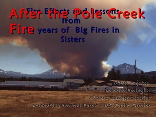
1. After the Pole Creek
Fire Effects and Lessons
from
Fire
10 years of Big Fires in
Sisters
Maret Pajutee
District Ecologist
Sisters Ranger District
Deschutes National Forest - US Forest Service
4. Historic accounts tell of frequent fire
“When I came to eastern Oregon in 1905…
each summer there were many wildfires…
caused by lightning. As there was no
underbrush, these fires consumed nothing
but the dead pine needles, cones and
twigs… the little blaze only a few inches
high crept slowly over the ground… but did
no damage whatever to green trees.”
Dr Urling Coe, Frontier Doctor
9. Weather Patterns
Insects and Disease
Rainfall Gradient
Its Fire Suppression
Climate Change
Complicated!
Past
Timber Harvest
Aspect and Slope
Forest Type
39. Weather Patterns
Insects and Disease
Fire Regimes
Its Fire Suppression
Climate Change
Complicated!
Timber Harvest
Forest/Urban Interface
Developments
Changing values
40.
41.
42. FIRE NAME YEAR ACRES
CACHE MTN 2002 3,886
LINK 2003 3,590
B AND B COMPLEX 2003 90,682
LAKE GEORGE 2006 5,533
4 fire – 103,691 acres
43. From 1998-2009- 70,000 acres died
Missed 0-3 Fire Cycles
Narrow band next to mixed conifer forests
Lodgepole at end of lifespan
Mortality east of Three Creeks
55. Pole Creek Fire
Effects
• Total fire size- 26,183 acres
• Headwaters Whychus Creek
o 42% burned, 4327 acres
• Upper Whychus Creek
o 54% burned, 4114 acres
o Total Vegetation Mortality
o 10,303 ac Stand replacement- 39%
o 9,374 ac Mixed severity- 36%
o 6,505 ac Low- 25%
o Soil erosion hazard
o Moderate to high -6800 acres or
26%
56. Burned Area
Emergency
Rehab
Concerns
• Steep burned slopes with
Moderate/High soil burn
severity
• Potential road damage and
washouts
• Sediment into Whychus
Creek and the Deschutes
River
• Risk of Invasive plants
57. • Loss of interception of snow and rain
• Loss of evapo-transporation
• Loss of soil cover
• More water flow
Impacts to Riparian Areas & Forests
58. Already
seeing
Higher
Flows
• 6 of top 11 peak flows in 102 years (1999-2009)
• More Rain on Snow
• Mortality in lodgepole forest
61. • Spawn February- April
• Floods in March/April- wash away eggs
• Sediment affects survival
Concerns for Steelhead Spawning
62. • 37 % of Pole
Creek riparian
and wetland
forests burned
moderate to
high severity.
• 61 % of Snow
Creek riparian
and wetland
forests burned
moderate to
high severity.
77. Fire/Disturbance
• High elevation forests-
– Fire intensity “natural”
– But bigger than historic Fire sizes due to Fire
suppression
• The more fire cycles missed- the more risk to
ecosystem components
• Decreased fire risk for 5 years
• Increased fuel loading as snags fall (5-60 years)
78. Fire/Disturbance
• Research Modeling predicts:
– More Fires
– Hotter Fires
– Larger Fires
– Longer fire seasons
– Migration of forest types
• From: Greaves, HE. 2012
79. Black Butte 2 reburn 2009
Black Butte Fire 1981 (28 years)
80. Canyon Creek Fire 2012
• B&B Fire area re-burn (9 years)
• Lower fire intensities
• 6-10 foot shrubs
• Standing & down wood
81. • Restore natural process
• Reduce risk of high intensity fires coming out of
wilderness
• Willamette and Deschutes proposal
• Scoping in Progress
Prescribed Fire in the Wilderness?
82. SOILS
Increased:
•Sediment delivery
from roads
•Erosion from loss of
soil cover
•Erosion from
increased peak flows
or flood events
84. WATER QUALITY
• More Peak Flows-
flood events
• Warmer water
temperatures
• Short term nutrient
increase in water for
4-6 years
(nitrates & phosphorus)
86. Forest Vegetation
• Larger landscape patches that more closely
resemble historic landscape patterns
• Loss of connectivity
• Loss of interior forest habitats
• Increase in early seral habitats
87. Forests do recover
• Can accelerate by planting
where seed sources are gone
– 30,000 acres planted on B&B
• Monitor natural regeneration
• Allow most areas to regenerate
naturally
106. Table 2. Percent fine sediment <2 mm and <5.7 mm
averaged for all four sites in riffle and pool habitats.
Water years prior to 2004 were below average.
2002 2003 2004* 2005
Fines
<2mm 25 23 28 (+3%) 27
Fines
<5.7mm 28 30 36 (+8%) 32
* p< 0.05
107. Large Instream Wood per mile
before and after Eyerly Fire
50
small wood large wood reach 1
40
pieces of wood /mile
reach 2
30
20
10
0
1999 2002 1999 2002
pre-fire post-fire pre-fire post-fire
108. Fire may drive a temporary
pulse in aquatic productivity
• >Sunlight
• >Nutrients
• > Temp
• >Plants
• >Insects
• >Fish and
wildlife food
From: Harris, et al, Idaho State University
109. WILDLIFE
• Loss of moist
forests and
owl habitat
and
connectivity
continues
Spotted Owls
• 21 known
owl sites
down to 3
110. •Other species
will thrive
•Woodpeckers
WILDLIFE •Big game
•Upland Birds
112. Roads
• Unraveling roads
• Hazard trees
• Need to upsize or remove
culverts
• Continue to reduce road densities
where appropriate
– 71 miles of roads closed after B&B
– 38 miles closed after Eyerly
• Continue to implement Travel
Management Plan
122. Salvage projects will
remain controversial
• 4,000 acres of salvage in B&B
• Road hazard tree salvage proposed for
Pole Creek
• Additional analysis underway
125. Summary
• Good Fire/Bad Fire?
– Fires are a part of life in Central Oregon and
will continue to occur.
– Their effects and cycles vary. Its complicated!
• We are working to restore conditions to
reduce risks to people and ecosystems
• We need your help and understanding.
– Get involved with your public lands.