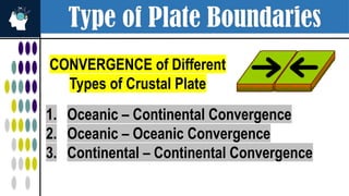
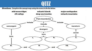
Type of PlateBoundaries
CONVERGENCE of Different
Types of Crustal Plate
1. Oceanic – Continental Convergence
2. Oceanic – Oceanic Convergence
3. Continental – Continental Convergence
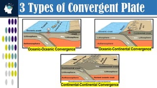
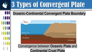
3 Types ofConvergent Plate
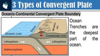
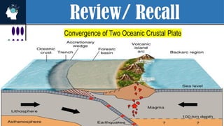
Oceanic-Continental Convergent Plate Boundary
Convergence between Oceanic Plate and
Continental Crust Plate
6.
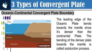
3 Types ofConvergent Plate
Oceanic-Continental Convergent Plate Boundary
The leading edge of the
Oceanic Plate bends
towards the mantle since
it’s denser than the
continental Plate. The
bending of the denser plate
towards the mantle is
called subduction process.
7.
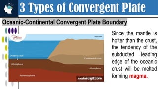
3 Types ofConvergent Plate
Oceanic-Continental Convergent Plate Boundary
Since the mantle is
hotter than the crust,
the tendency of the
subducted leading
edge of the oceanic
crust will be melted
forming magma.
8.
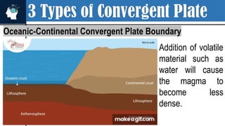
3 Types ofConvergent Plate
Oceanic-Continental Convergent Plate Boundary
Addition of volatile
material such as
water will cause
the magma to
become less
dense.
9.
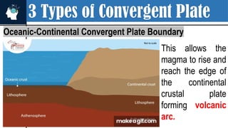
3 Types ofConvergent Plate
Oceanic-Continental Convergent Plate Boundary
This allows the
magma to rise and
reach the edge of
the continental
crustal plate
forming volcanic
arc.
10.
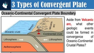
3 Types ofConvergent Plate
Oceanic-Continental Convergent Plate Boundary
Aside from Volcanic
arc, what other
geologic events
could be formed in
convergence of
Oceanic-Continental
Crustal Plates?
11.
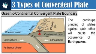
3 Types ofConvergent Plate
Oceanic-Continental Convergent Plate Boundary
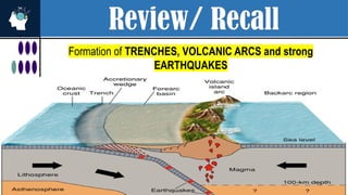
The continups
grinding of plates
against each other
will cause the
occurrence of
Earthquakes.
12.
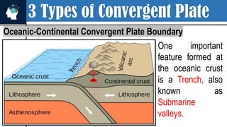
3 Types ofConvergent Plate
Oceanic-Continental Convergent Plate Boundary
One important
feature formed at
the oceanic crust
is a Trench, also
known as
Submarine
valleys.
13.
3 Types ofConvergent Plate
Oceanic-Continental Convergent Plate Boundary
Ocean
Trenches are
the deepest
part of the
ocean.
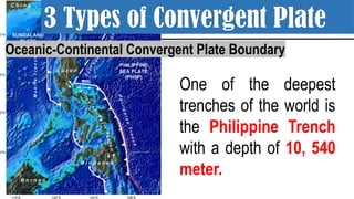
14.
One of thedeepest
trenches of the world is
the Philippine Trench
with a depth of 10, 540
meter.
Oceanic-Continental Convergent Plate Boundary
3 Types of Convergent Plate
15.
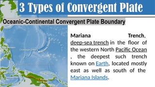
Mariana Trench,
deep-sea trenchin the floor of
the western North Pacific Ocean
, the deepest such trench
known on Earth, located mostly
east as well as south of the
Mariana Islands.
3 Types of Convergent Plate
Oceanic-Continental Convergent Plate Boundary
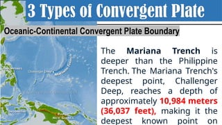
16.
The Mariana Trenchis
deeper than the Philippine
Trench. The Mariana Trench's
deepest point, Challenger
Deep, reaches a depth of
approximately 10,984 meters
(36,037 feet), making it the
deepest known point on
3 Types of Convergent Plate
Oceanic-Continental Convergent Plate Boundary
17.
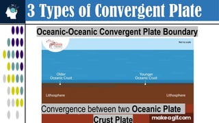
3 Types ofConvergent Plate
Oceanic-Oceanic Convergent Plate Boundary
Convergence between two Oceanic Plate
Crust Plate
18.
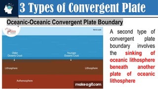
3 Types ofConvergent Plate
Oceanic-Oceanic Convergent Plate Boundary
A second type of
convergent plate
boundary involves
the sinking of
oceanic lithosphere
beneath another
plate of oceanic
lithosphere
19.
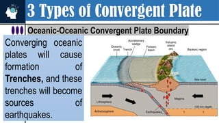
3 Types ofConvergent Plate
Oceanic-Oceanic Convergent Plate Boundary
Converging oceanic
plates will cause
formation of
Trenches, and these
trenches will become
sources of
earthquakes.
20.
3 Types ofConvergent Plate
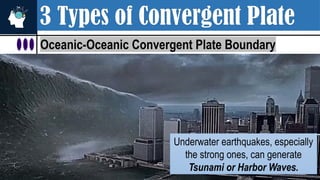
Oceanic-Oceanic Convergent Plate Boundary
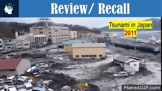
Underwater earthquakes, especially
the strong ones, can generate
Tsunami or Harbor Waves.
21.
3 Types ofConvergent Plate
Oceanic-Oceanic Convergent Plate Boundary
The leading edge of the subducted plate will eventually reach the mantle causing
it to melt and turn into magma. The molten material will rise to the surface
creating a Volcanic Island Arc Parallel to the trench.
22.
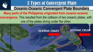
3 Types ofConvergent Plate
Oceanic-Oceanic Convergent Plate Boundary
Many parts of the Philippines originated from oceanic-oceanic
convergence. This resulted from the collision of two oceanic plates, with
one of the plates diving under the other.
OCEANIC CRUST
OCEANIC CRUST
23.
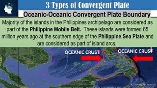
3 Types ofConvergent Plate
Oceanic-Oceanic Convergent Plate Boundary
Majority of the islands in the Philippines archipelago are considered as
part of the Philippine Mobile Belt. These islands were formed 65
million years ago at the southern edge of the Philippine Sea Plate and
are considered as part of island arcs.
OCEANIC CRUST
OCEANIC CRUST
24.
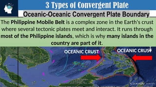
3 Types ofConvergent Plate
Oceanic-Oceanic Convergent Plate Boundary
The Philippine Mobile Belt is a complex zone in the Earth's crust
where several tectonic plates meet and interact. It runs through
most of the Philippine islands, which is why many islands in the
country are part of it.
OCEANIC CRUST
OCEANIC CRUST
25.
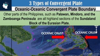
3 Types ofConvergent Plate
Oceanic-Oceanic Convergent Plate Boundary
Other parts of the Philippines, such as Palawan, Mindoro, and the
Zamboanga Peninsula are all highland sections of the Sundaland
Block of the Eurasian Plate.
OCEANIC CRUST
OCEANIC CRUST
26.
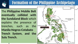
Formation of thePhilippine Archipelago
The Philippine Mobile Belt
eventually collided with
the Sundaland Block which
explains the presence of
trenches, such as the
Manila-Negros-Cotabato
Trench System, and the
Sulu Trench.
OCEANIC CRUST
MANILA
TRENCH
SULU TRENCH
SULU TRENCH
NEGROS TRENCH
27.
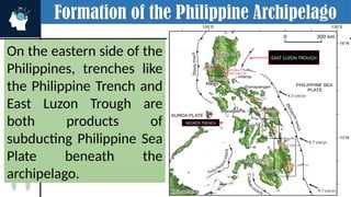
Formation of thePhilippine Archipelago
On the eastern side of the
Philippines, trenches like
the Philippine Trench and
East Luzon Trough are
both products of
subducting Philippine Sea
Plate beneath the
archipelago.
OCEANIC CRUST
SULU TRENCH
SULU TRENCH
NEGROS TRENCH
EAST LUZON TROUGH
28.
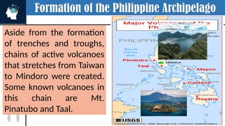
Formation of thePhilippine Archipelago
Aside from the formation
of trenches and troughs,
chains of active volcanoes
that stretches from Taiwan
to Mindoro were created.
Some known volcanoes in
this chain are Mt.
Pinatubo and Taal.
OCEANIC CRUST
EAST LUZON TROUGH
29.
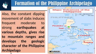
Formation of thePhilippine Archipelago
Also, the constant dipping
movement of slabs induces
frequent moderate to
strong earthquakes at
various depths, gives rise
to mountain ranges and
develops the geologic
character of the Philippine
Archipelago
OCEANIC CRUST
EAST LUZON TROUGH
30.
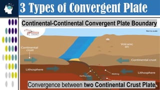
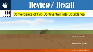
3 Types ofConvergent Plate
Continental-Continental Convergent Plate Boundary
Convergence between two Continental Crust Plate
31.
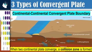
3 Types ofConvergent Plate
Continental-Continental Convergent Plate Boundary
When two continental plate converge, a collision zone is formed.
32.
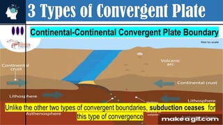
3 Types ofConvergent Plate
Continental-Continental Convergent Plate Boundary
Unlike the other two types of convergent boundaries, subduction ceases for
this type of convergence
33.
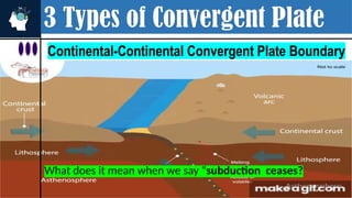
3 Types ofConvergent Plate
Continental-Continental Convergent Plate Boundary
What does it mean when we say “subduction ceases?
34.
3 Types ofConvergent Plate
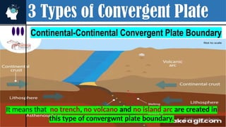
Continental-Continental Convergent Plate Boundary
It means that no trench, no volcano and no island arc are created in
this type of convergwnt plate boundary.
35.
3 Types ofConvergent Plate
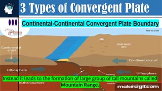
Continental-Continental Convergent Plate Boundary
Instead it leads to the formation of large group of tall mountains called
Mountain Range.
36.
3 Types ofConvergent Plate
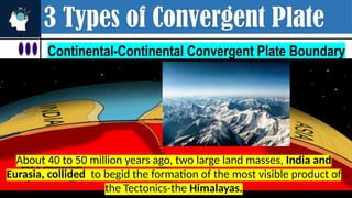
Continental-Continental Convergent Plate Boundary
About 40 to 50 million years ago, two large land masses, India and
Eurasia, collided to begid the formation of the most visible product of
the Tectonics-the Himalayas.
37.
3 Types ofConvergent Plate
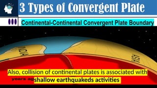
Continental-Continental Convergent Plate Boundary
Also, collision of continental plates is associated with
shallow earthquakeds activities
38.
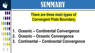
SUMMARY
There are threemain types of
Convergent Plate Boundary;
1. Oceanic – Continental Convergence
2. Oceanic – Oceanic Convergence
3. Continental – Continental Convergence
39.
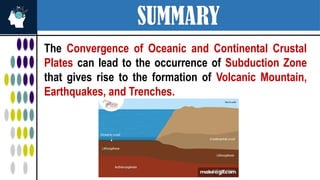
SUMMARY
The Convergence ofOceanic and Continental Crustal
Plates can lead to the occurrence of Subduction Zone
that gives rise to the formation of Volcanic Mountain,
Earthquakes, and Trenches.
40.
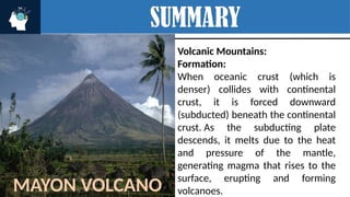
SUMMARY
Volcanic Mountains:
Formation:
When oceaniccrust (which is
denser) collides with continental
crust, it is forced downward
(subducted) beneath the continental
crust. As the subducting plate
descends, it melts due to the heat
and pressure of the mantle,
generating magma that rises to the
surface, erupting and forming
volcanoes.
MAYON VOLCANO
41.
SUMMARY
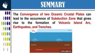
The Convergence oftwo Oceanic Crustal Plates can
lead to the occurrence of Subduction Zone that gives
rise to the formation of Volcanic Island Arc,
Earthquakes, and Trenches.
42.
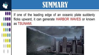
SUMMARY
If one ofthe leading edge of an oceanic plate suddenly
flicks upward, it can generate HARBOR WAVES or known
as TSUNAMI.
43.
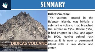
SUMMARY
Didicas Volcano:
This volcano,located in the
Babuyan Islands, was initially a
submarine volcano that breached
the surface in 1952. Before 1952,
it had erupted in 1857, and again
in 1900, leaving behind rock
masses. It is now a permanent
island with a lava dome and
crater.
DIDICAS VOLCANO
44.
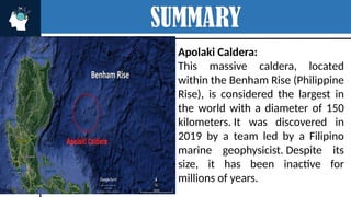
SUMMARY
Apolaki Caldera:
This massivecaldera, located
within the Benham Rise (Philippine
Rise), is considered the largest in
the world with a diameter of 150
kilometers. It was discovered in
2019 by a team led by a Filipino
marine geophysicist. Despite its
size, it has been inactive for
millions of years.
DIDICAS ISLAND
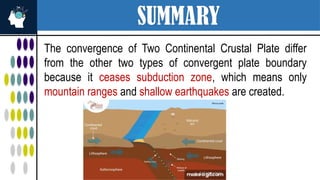
SUMMARY
The convergence ofTwo Continental Crustal Plate differ
from the other two types of convergent plate boundary
because it ceases subduction zone, which means only
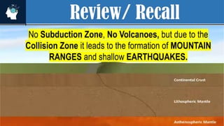
mountain ranges and shallow earthquakes are created.
47.
SUMMARY
The convergence ofTwo Continental Crustal Plate differ
from the other two types of convergent plate boundary
because it ceases subduction zone, which means only
mountain ranges and shallow earthquakes are created.
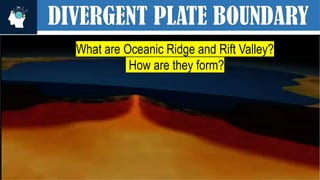
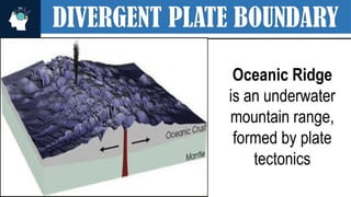
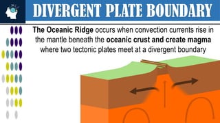
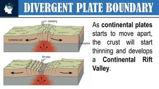
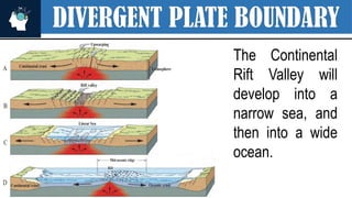
DIVERGENT PLATE BOUNDARY
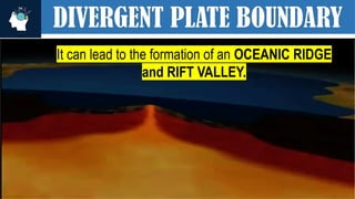
TheOceanic Ridge occurs when convection currents rise in
the mantle beneath the oceanic crust and create magma
where two tectonic plates meet at a divergent boundary
64.
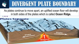
DIVERGENT PLATE BOUNDARY
Asplates continue to move apart, an uplifted ocean floor will develop
in both sides of the plates which is called Ocean Ridge.
65.
DIVERGENT PLATE BOUNDARY
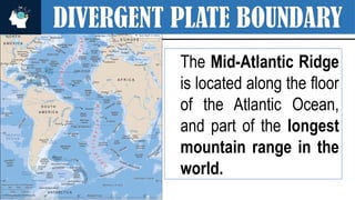
TheMid-Atlantic Ridge
is located along the floor
of the Atlantic Ocean,
and part of the longest
mountain range in the
world.
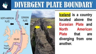
DIVERGENT PLATE BOUNDARY
Icelandis a country
located above the
Eurasian Plate and
North American
Plate that are
diverging from one
another.
72.
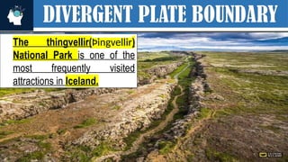
DIVERGENT PLATE BOUNDARY
Thethingvellir(Þingvellir)
National Park is one of the
most frequently visited
attractions in Iceland.
73.
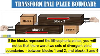
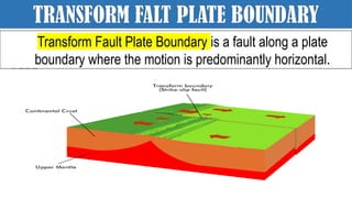
TRANSFORM FALT PLATEBOUNDARY
If the blocks represent the lithospheric plates, you will
notice that there were two sets of divergent plate
boundaries – between blocks 1 and 2, and blocks 3 and 4
74.
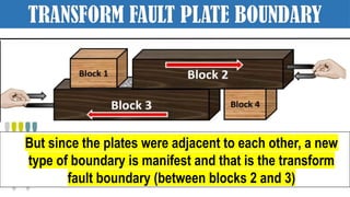
TRANSFORM FAULT PLATEBOUNDARY
But since the plates were adjacent to each other, a new
type of boundary is manifest and that is the transform
fault boundary (between blocks 2 and 3)
75.
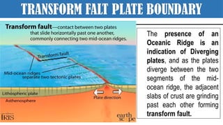
TRANSFORM FALT PLATEBOUNDARY
The presence of an
Oceanic Ridge is an
indication of Diverging
plates, and as the plates
diverge between the two
segments of the mid-
ocean ridge, the adjacent
slabs of crust are grinding
past each other forming
transform fault.
76.
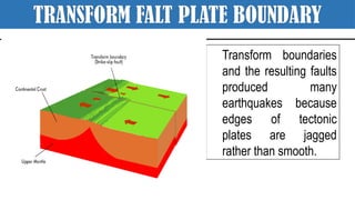
TRANSFORM FALT PLATEBOUNDARY
Transform boundaries
and the resulting faults
produced many
earthquakes because
edges of tectonic
plates are jagged
rather than smooth.
77.
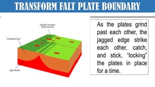
TRANSFORM FALT PLATEBOUNDARY
As the plates grind
past each other, the
jagged edge strike
each other, catch,
and stick, “locking”
the plates in place
for a time.
78.
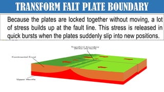
TRANSFORM FALT PLATEBOUNDARY
Because the plates are locked together without moving, a lot
of stress builds up at the fault line. This stress is released in
quick bursts when the plates suddenly slip into new positions.
79.
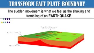
TRANSFORM FALT PLATEBOUNDARY
The sudden movement is what we feel as the shaking and
trembling of an EARTHQUAKE
80.
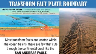
TRANSFORM FALT PLATEBOUNDARY
Most transform faults are located within
the ocean basins, there are few that cuts
through the continental crust like the
81.
SUMMARY
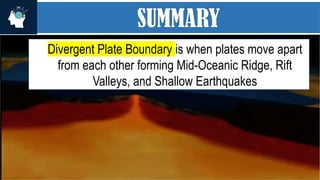
Divergent Plate Boundaryis when plates move apart
from each other forming Mid-Oceanic Ridge, Rift
Valleys, and Shallow Earthquakes
82.
TRANSFORM FALT PLATEBOUNDARY
Transform Fault Plate Boundary is a fault along a plate
boundary where the motion is predominantly horizontal.
83.
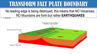
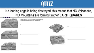
TRANSFORM FALT PLATEBOUNDARY
No leading edge is being destroyed, this means that NO Volcanoes,
NO Mountains are form but rather EARTHQUAKES
84.
QUIZ
No leading edgeis being destroyed, this means that NO Volcanoes,
NO Mountains are form but rather EARTHQUAKES
85.
QUIZ
No leading edgeis being destroyed, this means that NO Volcanoes,
NO Mountains are form but rather EARTHQUAKES
86.
QUIZ
No leading edgeis being destroyed, this means that NO Volcanoes,
NO Mountains are form but rather EARTHQUAKES
87.
QUIZZ
No leading edgeis being destroyed, this means that NO Volcanoes,
NO Mountains are form but rather EARTHQUAKES
Editor's Notes
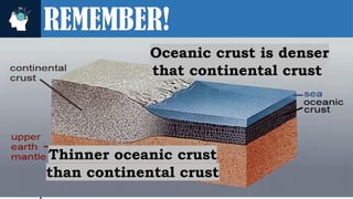
#2 This idea is very important to help you understand the geologic process occurring along the diff. types of plate boundary.
#3 The GEOLOGIC PROCESSES THAT WILL BE FORMED ALONG THIS TYPE OF PLATE BOUNDARY DEPENDS ON THE MATERIAL OF PLATES THAT ARE COLLIDING
#4 Let’s take a look on each type of plate boundary
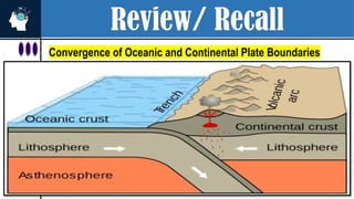
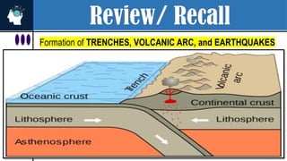
#5 This figure shows the convergence between the Convergence between Oceanic Plate and Continental Crust Plate
#6 As two different plate collide The leading edge of the Oceanic Plate bends towards the mantle since it’s denser than the continental Plate. The bending of the denser plate towards the mantle is called subduction process.
#14 The Mariana Trench is deeper than the Philippine Trench. The Mariana Trench's deepest point, Challenger Deep, reaches a depth of approximately 10,984 meters (36,037 feet), making it the deepest known point on Earth. The Philippine Trench has a maximum depth of around 10,540 meters (34,580 feet).
#15 The Mariana Trench is deeper than the Philippine Trench. The Mariana Trench's deepest point, Challenger Deep, reaches a depth of approximately 10,984 meters (36,037 feet), making it the deepest known point on Earth. The Philippine Trench has a maximum depth of around 10,540 meters (34,580 feet).
#16 The Mariana Trench is deeper than the Philippine Trench. The Mariana Trench's deepest point, Challenger Deep, reaches a depth of approximately 10,984 meters (36,037 feet), making it the deepest known point on Earth. The Philippine Trench has a maximum depth of around 10,540 meters (34,580 feet).
#17 This figure shows the convergence between the Convergence between Oceanic Plate and Continental Crust Plate
#20 Underwater earthquakes, especially the strong ones, can generate Tsunami or Harbor Waves.
#23 The Philippine Mobile Belt is a complex zone in the Earth's crust where several tectonic plates meet and interact. It runs through most of the Philippine islands, which is why many islands in the country are part of it.
Island arcs are groups of islands formed from volcanic eruptions caused by subduction zones.
The Philippines is an example of this. Many of our islands were formed from volcanoes millions of years ago.
Most of the Philippine islands are part of the Philippine Mobile Belt, a zone where tectonic plates collide. These islands formed 65 million years ago due to volcanic activity at the edge of the Philippine Sea Plate, creating island arcs like the ones we see today.
How Were the Islands Formed?
Around 65 million years ago, the islands began forming.
This happened at the southern edge of the Philippine Sea Plate.
These islands didn't just rise from nowhere—they were formed through a process called subduction, where one tectonic plate slides under another.
This process caused volcanic activity, which slowly created island arcs (curved chains of volcanic islands).
#24 The Philippine Mobile Belt is a complex zone in the Earth's crust where several tectonic plates meet and interact. It runs through most of the Philippine islands, which is why many islands in the country are part of it.
Island arcs are groups of islands formed from volcanic eruptions caused by subduction zones.
The Philippines is an example of this. Many of our islands were formed from volcanoes millions of years ago.
Most of the Philippine islands are part of the Philippine Mobile Belt, a zone where tectonic plates collide. These islands formed 65 million years ago due to volcanic activity at the edge of the Philippine Sea Plate, creating island arcs like the ones we see today.
How Were the Islands Formed?
Around 65 million years ago, the islands began forming.
This happened at the southern edge of the Philippine Sea Plate.
These islands didn't just rise from nowhere—they were formed through a process called subduction, where one tectonic plate slides under another.
This process caused volcanic activity, which slowly created island arcs (curved chains of volcanic islands).
#25 The Philippine Mobile Belt is a complex zone in the Earth's crust where several tectonic plates meet and interact. It runs through most of the Philippine islands, which is why many islands in the country are part of it.
Island arcs are groups of islands formed from volcanic eruptions caused by subduction zones.
The Philippines is an example of this. Many of our islands were formed from volcanoes millions of years ago.
Most of the Philippine islands are part of the Philippine Mobile Belt, a zone where tectonic plates collide. These islands formed 65 million years ago due to volcanic activity at the edge of the Philippine Sea Plate, creating island arcs like the ones we see today.
How Were the Islands Formed?
Around 65 million years ago, the islands began forming.
This happened at the southern edge of the Philippine Sea Plate.
These islands didn't just rise from nowhere—they were formed through a process called subduction, where one tectonic plate slides under another.
This process caused volcanic activity, which slowly created island arcs (curved chains of volcanic islands).
#30 This figure shows the convergence between the Convergence between Oceanic Plate and Continental Crust Plate
#31 This figure shows the convergence between the Convergence between Oceanic Plate and Continental Crust Plate
#32 This figure shows the convergence between the Convergence between Oceanic Plate and Continental Crust Plate
#33 What does it mean when we say “subduction ceases?
#34 What does it mean when we say “subduction ceases?
#35 What does it mean when we say “subduction ceases?
#36 What does it mean when we say “subduction ceases?
#37 What does it mean when we say “subduction ceases?
#38 The GEOLOGIC PROCESSES THAT WILL BE FORMED ALONG THIS TYPE OF PLATE BOUNDARY DEPENDS ON THE MATERIAL OF PLATES THAT ARE COLLIDING
#39 The GEOLOGIC PROCESSES THAT WILL BE FORMED ALONG THIS TYPE OF PLATE BOUNDARY DEPENDS ON THE MATERIAL OF PLATES THAT ARE COLLIDING
#40 A well-known example of a volcano in the Philippines is Mayon Volcano, located in the Bicol Region of Luzon. It is known for its near-perfect cone shape and is considered the most active volcano in the country.
#41 The GEOLOGIC PROCESSES THAT WILL BE FORMED ALONG THIS TYPE OF PLATE BOUNDARY DEPENDS ON THE MATERIAL OF PLATES THAT ARE COLLIDING
#42 The GEOLOGIC PROCESSES THAT WILL BE FORMED ALONG THIS TYPE OF PLATE BOUNDARY DEPENDS ON THE MATERIAL OF PLATES THAT ARE COLLIDING
#46 The GEOLOGIC PROCESSES THAT WILL BE FORMED ALONG THIS TYPE OF PLATE BOUNDARY DEPENDS ON THE MATERIAL OF PLATES THAT ARE COLLIDING
#47 The GEOLOGIC PROCESSES THAT WILL BE FORMED ALONG THIS TYPE OF PLATE BOUNDARY DEPENDS ON THE MATERIAL OF PLATES THAT ARE COLLIDING
#50 In convergent plate boundary, the lithospheric plates are moving towards each other where one leading edge of a plate will be subducted and turned it into magma. Just like in the convergence of Oceanic and continental crustal plates.
#51 In convergent plate boundary, the lithospheric plates are moving towards each other where one leading edge of a plate will be subducted and turned it into magma. Just like in the convergence of Oceanic and continental crustal plates. THAT GIVES RISE TO THE Formation of TRENCHES, VOLCANIC ARC, and EARTHQUAKES
#52 In convergent plate boundary, the lithospheric plates are moving towards each other where one leading edge of a plate will be subducted and turned it into magma. Just like in the convergence of Oceanic and continental crustal plates. THAT GIVES RISE TO THE Formation of TRENCHES, VOLCANIC ARC, and EARTHQUAKES
#53 IN Convergence of Two Oceanic Crustal Plate IT LEADS TO THE Formation of TRENCHES, VOLCANIC ARCS and strong EARTHQUAKES
#54 IN Convergence of Two Oceanic Crustal Plate IT LEADS TO THE Formation of TRENCHES, VOLCANIC ARCS and strong EARTHQUAKES
#55 IN Convergence of Two Oceanic Crustal Plate IT LEADS TO THE Formation of TRENCHES, VOLCANIC ARCS and strong EARTHQUAKES that can generate tsunami like what happen in JAPAN IN 2011.
#56 THE LAST TYPE OF CONVERGENT PLATE BOUNDARY WHERE TWO CONTINENTAL CRUSTAL PLATE COLLIDE, THERE IS NO SUBDUCTION ZONE
#57 THE LAST TYPE OF CONVERGENT PLATE BOUNDARY WHERE TWO CONTINENTAL CRUSTAL PLATE COLLIDE, THERE IS NO SUBDUCTION ZONE.
Therefore no VOLCANOES BUT RATHER A COLLISION ZONE HAPPENS THAT CREATE MT. RANGES AND SHALLOW EARTHQUAKES.
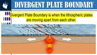
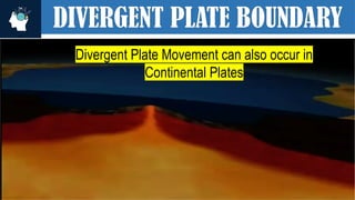
#58 Divergent Plate Boundary is when the lithospheric plates are moving apart from each other.
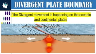
#59 Divergent Plate Boundary is when the lithospheric plates are moving apart from each other. If the Divergent movement is happening on the oceanic plates
#60 Divergent Plate Boundary is when the lithospheric plates are moving apart from each other. If the Divergent movement is happening on the oceanic plates
#61 Divergent Plate Boundary is when the lithospheric plates are moving apart from each other. If the Divergent movement is happening on the oceanic plates
#62 Divergent Plate Boundary is when the lithospheric plates are moving apart from each other. If the Divergent movement is happening on the oceanic plates
#63 Divergent Plate Boundary is when the lithospheric plates are moving apart from each other. If the Divergent movement is happening on the oceanic plates
#64 Divergent Plate Boundary is when the lithospheric plates are moving apart from each other. If the Divergent movement is happening on the oceanic plates
#65 Divergent Plate Boundary is when the lithospheric plates are moving apart from each other. If the Divergent movement is happening on the oceanic plates
#66 Divergent Plate Boundary is when the lithospheric plates are moving apart from each other. If the Divergent movement is happening on the oceanic plates
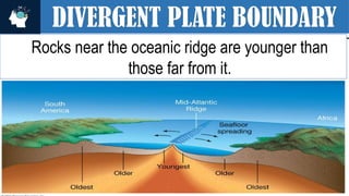
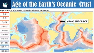
#67 This map tells the Age of the Earth’s Crust in million years.
RED MEANS YOUNGEST OCEANIC CRUST AND BLUE MEANS THE OLDEST.
CLEARLY ROCKS NEAR THE OCEANIC RIDGES ARE YOUNGER THAN FAR FROM IT. THAT’S WHY DIVERGENT PLATE BOUNDARY IS ALSO KNOWN AS CONSTRUCTIVE PLATE BOUNDARY BECAUSE NEW MATERIALS ARE BEING FORMED.
#68 Divergent Plate Boundary is when the lithospheric plates are moving apart from each other. If the Divergent movement is happening on the oceanic plates
#69 Divergent Plate Boundary is when the lithospheric plates are moving apart from each other. If the Divergent movement is happening on the oceanic plates
#70 Divergent Plate Boundary is when the lithospheric plates are moving apart from each other. If the Divergent movement is happening on the oceanic plates
#71 Divergent Plate Boundary is when the lithospheric plates are moving apart from each other. If the Divergent movement is happening on the oceanic plates
#76 jag·ged - having rough, sharp points protruding.
#77 jag·ged - having rough, sharp points protruding.
#78 jag·ged - having rough, sharp points protruding.
#79 jag·ged - having rough, sharp points protruding.
#80 jag·ged - having rough, sharp points protruding.
#81 Divergent Plate Boundary is when the lithospheric plates are moving apart from each other. If the Divergent movement is happening on the oceanic plates
#82 jag·ged - having rough, sharp points protruding.
#83 jag·ged - having rough, sharp points protruding.
#84 jag·ged - having rough, sharp points protruding.
#85 jag·ged - having rough, sharp points protruding.
#86 jag·ged - having rough, sharp points protruding.
#87 jag·ged - having rough, sharp points protruding.
#88 jag·ged - having rough, sharp points protruding.


![谷歌留痕技术 [ 𝙩𝙤𝙥 𝟮𝟯𝟯. 𝙘 𝙤𝙢 ]](https://cdn.slidesharecdn.com/ss_thumbnails/top233-260130174328-3833018c-thumbnail.jpg?width=640&height=640&fit=bounds)


