
Recommended
Recommended
More Related Content
Similar to Orchard Beach, Pelham BayVirtual Field TripWhere are.docx
Similar to Orchard Beach, Pelham BayVirtual Field TripWhere are.docx (20)
More from jacksnathalie
More from jacksnathalie (20)
Recently uploaded
Recently uploaded (20)
Orchard Beach, Pelham BayVirtual Field TripWhere are.docx
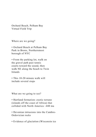
- 1. Orchard Beach, Pelham Bay Virtual Field Trip Where are we going? • Orchard Beach at Pelham Bay Park in Bronx, Northernmost borough of NYC • From the parking lot, walk on the gravel path past tennis courts toward the sound, then walk NE along the beach to Twin Islands • This 10-20 minute walk will include several stops What are we going to see? • Hartland formation: exotic terrane (islands off the coast of Africa) that collided with North America ~440 ma • Devonian intrusions into the Cambro- Ordovician rocks • Evidence of glaciation (Wisconsin ice
- 2. sheet, 1000 ft thick in this part of NY, ~11 ka -80 ka) • Sediments that were metamorphosed during Taconic and Acadian orogenies • Quartz-feldspar gneiss, biotite-sillimanite schist, amphibolite • Glacial till, glacial erratics, striations, outwash plain, terminal moraine in the distance Map of NYC geology – US geological Survey Tectonic evolution of the east coast: • Follow along with this cartoon version of the area’s tectonic history in your handout • Overview: • Grenville Orogeny completed the assembly of Rodinia, ~1.5-1 ba • Post-Grenville rifting created Iapetus ocean • Iapetus ocean started closing • Three pulses of Appalachian mountain building, Taconian, Acadian, and Alleghanian orogenies, close Iapetus Ocean • Pangea breaks up in the Mesozoic, rifting creates Atlantic ocean
- 3. • In this field trip we have glimpses into two of the three pulses of Appalachian mountain- building during early stages of Iapetan closure: the Taconic Orogeny (Cambro- Ordovician), and the Acadian Orogeny (late Devonian) Adapted from Earth: Portrait of a Planet by Steve Marshak Glaciation and 1st stop • The top stratigraphic layers are much younger than the tectonic events described in the previous slide • Ice age in the Pleistocene shaped landscape, modified drainage, and eroded strata • Last advance of ice: Wisconsin stage of the Laurentide ice sheet • Terminal moraine at the edge of the ice sheet creates Long Island • Long Island Sound was a glacial lake; as climate warmed and sea level rose, the outwash lake became an estuary then a sound; tall points of the moraine are now islands
- 4. 2nd stop: Hartland formation • Hartland formation: exotic terrane (islands off the coast of Africa) that collided with North America ~440 ma • Sediments that were metamorphosed during two of the three pulses of Appalachian mountain building: Taconic and Acadian orogenies (check tectonic evolution cartoon in your handout) • Quartz-feldspar gneiss, biotite- sillimanite schist, amphibolite • Follow the links; hope you can hear me over the wind! • https://youtu.be/aXcqGEgAH2k • Severe deformation • Partial melting of the schists and gneiss produced abundant quartz- feldspar leucosomes • Leucosomes: lenticular shape, coarse- grained, variable thickness, high-grade metamorphism product • Garnets: metamorphic index mineral • https://youtu.be/j8YZUQWN1j4 https://youtu.be/aXcqGEgAH2k
- 5. https://youtu.be/j8YZUQWN1j4 Close up of garnet porphyroblasts Cavities left by dissolution of calcite in amphibolite Folded leucosomes in the Hartland formation Glacial landscape • Glacial grooves and striations in Hartland formation • https://youtu.be/U8yFnGqG9A0 • Unconformity: glacial till overlying the Hartland formation • https://youtu.be/tq-sIopV3Uw Glacial erratics at Orchard Beach https://youtu.be/U8yFnGqG9A0 https://youtu.be/tq-sIopV3Uw Devonian dikes with straight planar boundaries, unaffected by tight folding that deformed Taconian leucosomes • https://youtu.be/NzwoYABulsw • https://youtu.be/UWDHv9_ogCI
- 6. Note glacially formed Long Island Sound in the background; Long Island, across the sound, is a terminal moraine Cross-cutting relationships – Devonian dikes intrude Cambro-Ordovician Hartland rock https://youtu.be/NzwoYABulsw https://youtu.be/UWDHv9_ogCI Metamorphosed turbidites • Rhythmically bedded sequences of gneiss and schist occur; these are interpreted as turbidites, deposits from sediment-laden flows spewed into deep water. On the northwestern side of North Twin Island, graded bedding is preserved, allowing us to deduce the direction of stratigraphic tops • https://youtu.be/z1Tl1BnZVho • The last hurrah – more cross- cutting relationships: • https://youtu.be/iJAVnPGg5v0 https://youtu.be/z1Tl1BnZVho https://youtu.be/iJAVnPGg5v0
- 7. Thank you • To my son Lev for his phone camera wielding skills • To all of you for coming along on this virtual trip with me • References: • https://pbisotopes.ess.sunysb.edu/reports/ny-city/ • http://geologycafe.com/nyc/common/captions.htm • https://blogs.agu.org/mountainbeltway/2010/03/25/transect- debrief-5- sedimentation-continues/ • http://www.geo.hunter.cuny.edu/courses/geog260/PP5- 2011Glaciation.pdf Contributions to the Paleontology of New Jersey (II) 106 STOP 5: GINGERBREAD CASTLE STROMATOLITES, HAMBURG, NJ Deborah Freile1, Emma C. Rainforth2, and Gregory Herman3 1Department of Geoscience and Geography, New Jersey City University, 2039 Kennedy Blvd., Jersey City, NJ 07305; [email protected] 2Environmental Science, Ramapo College of New Jersey, 505 Ramapo Valley Road, Mahwah, NJ 07430; [email protected] 3New Jersey Geological Survey, P.O. Box 425, Trenton, NJ
- 8. 08625; [email protected] Collecting is not permitted at this outcrop. Leave hammers in the buses. LOCATION Hamburg 7.5 minute quadrangle. This spectacular outcrop is on private property; permission to visit must be obtained from Diversified Communities. Hammering is not permitted (and would ruin the outcrop for future visitors). Use caution on the outcrop; surfaces are steep and may be slippery. Excellent examples of features described may be seen at the base of each slope. INTRODUCTION This spectacular outcrop is of stromatolitic Allentown Dolomite (Middle Cambrian – lowermost Ordovician), a shallow water, nearshore carbonate that was periodically subaerially exposed. Dolomitization of the original carbonate preserved many of the original textures (Monteverde 2004). The outcrop consists of ‘whalebacks’ – roche moutonnées carved by glaciers, with the strata dipping to the northwest (Figure 1).
- 9. Figure 1. View of outcrop prior to present construction. Ground level is currently slightly lower and the right end of the outcrop has been removed, permitting examination of the outcrop in cross-section. GANJ XXIV Annual Conference and Field Trip 107 STROMATOLITES Stromatolites are ‘discrete, in-place structures with recognizable boundaries that are characterized by “gravity-defying” internal laminae reflecting addition of material to a discrete surface’ (Demicco and Hardie, 1994, p. 104). These cyanobacterial three-dimensional laminated structures first appeared ~3.5 Ga, peaking 1.65 – 0.65 Ga; they declined dramatically after the Early Ordovician, coinciding with the increase in epifaunal grazers and burrowers (Demicco and Hardie 1994). They are generally classified as 1) laterally linked hemispheroids, 2) discrete vertically stacked hemispheroids or 3) discrete spheroids (Logan et al., 1964). Combinational forms also exist. The term thrombolite (Aitken, 1967) was proposed for structures without discrete laminations. Stromatolites today
- 10. form in a variety of settings, including shallow subtidal, intertidal and supratidal marine environments or in saline lacustrine environments. In salt ponds these features tend to be flat laminations instead of a more three dimensional feature (Cornee et al. 1992). The stromatolites (Figure 2) observed at this site are of the discrete spheroidal type, which tend to correlate with higher energy environments. The higher energy environment is also reinforced by the many storm layers present throughout the outcrop (Figures 3, 4). These storm layers are rich in ooids . Figure 2. Close-up of a portion of the uppermost bedding plane in the outcrop. In the center of the picture a collapse breccia is visible (see also Figure 3): material that fell into a cavity following minor dissolution. Immediately overlying this layer are mudcracked carbonates, visible in darker area in lower right portion of photograph; these indicate subaerial exposure at this time. Glacial striations are clearly visible in most of this photograph. Pencil for scale (adjacent to lower left stromatolite). Contributions to the Paleontology of New Jersey (II) 108
- 11. Figure 3. Oolitic layers; the lower darker-colored layer contains small ooids while the upper layer bears much larger ooids. Dark gray rip-up clasts occur near the interface of the two layers. Figure 4. Edgewise conglomerate; pebbles are ripped up form underlying layers. GANJ XXIV Annual Conference and Field Trip 109 Figure 5. Cross-sectional view of a collapse breccia associated with dissolution of material in-between stromatolite mounds. Additionally, these mounds appear to be cut by tidal channels and this can cause slumping that is filled by bioclasts and lithoclasts which were originally reworked desiccated tidal flat sediments (Figures 2, 5). Analogous conditions are presented by Wilson (1975) from the Late Cambrian algal mounds of central Texas (Llano Uplift) as well as other areas throughout the edges of the North American craton. The outcrop also includes desiccation cracks (Figure 2), which
- 12. supposes an intertidal to even supratidal environment. Desiccation cracks are characteristically associated with microbialites in peritidal environments (Burne and Moore, 1987). Both cyanobacterial and algal mats can be responsible for the formation of desiccation cracks in dolomitic sediments in the modern tidal flats of the Bahamas (Mitchell and Horton, 1995). Diagenetically, the outcrop shows extensive stylolites and fenestral porosity. Stylolites are pressure solution secondary sedimentary structures, while fenestral porosity and bird’s eye structures are syndepositional structures mainly found in supratidal algal related mud dominated sediments (Moore, 1989). PALEOENVIRONMENTAL INTERPRETATION We interpret this outcrop as having been formed in nearshore to marginal marine conditions (Figure 6). The presence of mudcracks, birds-eye structures, and tidal channels indicate subaerial exposure; the stromatolites and oolitic carbonates would have formed in shallow water. The section records several such fluctuations in base level. GLACIAL FEATURES The whaleback outcrops are glacially-carved roche moutonnées. Glacial striations are evident over most of the polished surfaces (Figure 1), and (along with the
- 13. outcrop orientation) indicate direction of glacial flow. In places, chatter marks are visible. Contributions to the Paleontology of New Jersey (II) 110 Figure 6. Paleoenvironmental reconstruction of the Gingerbread Castle stromatolite site. (Modified from Pratt et al., 1992.) HYDROGEOLOGY A hydrogeological framework study was conducted by the New Jersey Geological Survey at this development as part of a ground-water supply investigation. The well field at the development includes one 8-inch diameter supply well and five 6-inch diameter observation wells in bedrock. The bedrock aquifer is composed of the lower part of the Allentown Dolomite and the upper part of the Leithsville Fm. A profile view (Figure 7) of the hydrogeological framework was constructed based on optical televiewer, fluid-temperature and electrical-conductivity, caliper, heat- pulse flowmeter, and color video (VHS) borehole geophysical logs. Stratigraphic bedding and tectonic fracture orientations were measured using an optical televiewer.
- 14. GANJ XXIV Annual Conference and Field Trip 111 Figure 7. Hydrogeological framework of wellfield. REFERENCES Aitken, J.D., 1967. Classification and environmental significance of cryptalgal limestones and dolomites, with illustrations from the Cambrian and Ordovician of southwestern Alberta. Journal of Sedimentary Petrology 37: 1163-1179. Burne, R.V. and Moore, L.S., 1987. Microbialites: Organosedimentary deposits of benthic microbial communities. Palaios 2: 241-254. Cornee, A., Dickman, M., and Busson, G., 1992. Laminated cyanobacterial mats in sediments of solar salt works: Some sedimentological implications. Sedimentology 39: 599-612. Demicco, R.V. and L.A. Hardie, 1994. Sedimentary Structures and Early Diagenetic Features of Shallow Marine Carbonate Deposits. SEPM Atlas Series No. 1, 265 pp.
- 15. Logan, B.W., Rezak, R., and Ginsburg, R.N., 1964. Classification and environmental significance of algal stromatolites. Journal of Geology 72: 68-83. Mitchell, S.W. and Horton, R.A., 1995. Dolomitization of modern tidal flat, tidal creek, and lacustrine sediments, Bahamas. Pp. 201-221 in Curran, H.A. and White, B., (eds.), Terrestrial and Shallow Marine Geology of the Bahamas and Bermuda. Geological Society of America Special Paper 300. Monteverde, D.H., 2004. Stratigraphy and Correlation of the Paleozoic sedimentary units of New Jersey: Stop 6 - Allentown Dolomite, p. 87-91. In A.E. Gates (ed.), 2004 NAGT-ES Conference Field Trip Guide. NAGT/Rutgers-Newark. Moore, C.H., 1989. Carbonate Diagenesis and Porosity. Elsevier, Amsterdam, 338 pp. Pratt, B.R., James, N.P., and Cowan, C.A., 1992. Peritidal Carbonates. Pp. 303-322 in Walker, R.G. and James, N.P. (eds.), Facies Models. Geological Association of Canada. Wilson, J.L., 1975. Carbonate Facies in Geologic History. Springer-Verlag, Heidelberg, 471 pp. Downloaded from GeoScienceWorld with access from at 128.59.222.107 on Mar 24, 2017, 4:24 PM. (c) 2012 The American Association of Petroleum
- 16. Geologists;Shell Exploration & Production Downloaded from GeoScienceWorld with access from at 128.59.222.107 on Mar 24, 2017, 4:24 PM. (c) 2012 The American Association of Petroleum Geologists;Shell Exploration & Production Downloaded from GeoScienceWorld with access from at 128.59.222.107 on Mar 24, 2017, 4:24 PM. (c) 2012 The American Association of Petroleum Geologists;Shell Exploration & Production Downloaded from GeoScienceWorld with access from at 128.59.222.107 on Mar 24, 2017, 4:24 PM. (c) 2012 The American Association of Petroleum Geologists;Shell Exploration & Production Downloaded from GeoScienceWorld with access from at 128.59.222.107 on Mar 24, 2017, 4:24 PM. (c) 2012 The American Association of Petroleum Geologists;Shell Exploration & Production Downloaded from GeoScienceWorld with access from at 128.59.222.107 on Mar 24, 2017, 4:24 PM. (c) 2012 The American Association of Petroleum Geologists;Shell Exploration & Production Downloaded from GeoScienceWorld with access from at 128.59.222.107 on Mar 24, 2017, 4:24 PM. (c) 2012 The American Association of Petroleum Geologists;Shell Exploration & Production Downloaded from GeoScienceWorld with access from at 128.59.222.107 on Mar 24, 2017, 4:24 PM. (c) 2012 The American Association of Petroleum Geologists;Shell Exploration & Production Downloaded from GeoScienceWorld with access from at 128.59.222.107 on Mar 24, 2017, 4:24 PM. (c) 2012 The American Association of Petroleum Geologists;Shell Exploration & Production 2 Paleogeography of the Great American
- 17. Carbonate Bank of Laurentia in the Earliest Ordovician (Early Tremadocian): The Stonehenge Transgression James R. Derby1 Consultant, Leonard, Oklahoma, U.S.A. Robert J. Raine2 and M. Paul Smith3 Lapworth Museum of Geology, University of Birmingham, Edgbaston Birmingham, United Kingdom Anthony C. Runkel Minnesota Geological Survey, Saint Paul, Minnesota, U.S.A. ABSTRACT This chapter describes and presents a newly compiled map illustrating the paleogeography of Laurentia during the earliest Ordovician, a time when the great American carbonate bank was at one of its greatest extents and a period for which the most is understood. The map depicts the known or postulated extent of the inner detrital belt, the great American carbon- ate bank and the more problematic (commonly structurally relocated) outer detrital belt. The period on which the map is based and discussed in the accompanying text is based on the Early Ordovician (early Ibexian) (early Tremadocian) Stonehenge transgression. INTRODUCTION In 1980, while Derby and Ginsburg were preparing
- 18. Ginsburg for his talk at the 1980 Society of Economic Paleontologists and Mineralogists Research Confer- ence on the Carbonate and Orthoquartzite Suite (Dott and Byers, 1981), Ginsburg asked the questions, ‘‘Just what was the extent of the great American (carbonate) bank (GA[C]B)?’’ and ‘‘How broad was the GA(C)B?’’ At that time, no single map existed. In the process of answering those questions again in 2010, Derby real- ized that no modern platewide map of the original extent of the GACB exists, 30 yr later. To this day, authors continue to use a series of out- dated maps, all of which were also available in 1980. Many authors continue to use Kay’s famous map (1951). 5 Derby, James R., Robert J. Raine, Anthony C. Runkel, and M. Paul Smith, 2012, Paleogeography of the great American carbonate bank of Laurentia in the earliest Ordovician (early Tremadocian): The Stonehenge transgression, in J. R. Derby, R. D. Fritz, S. A. Longacre, W. A. Morgan, and C. A. Sternbach, eds., The great American carbonate bank: The geology and economic resources of the Cambrian– Ordovician Sauk megasequence of Laurentia: AAPG Memoir 98, p. 5–13.
- 19. 1Present address: Department of Geosciences, University of Tulsa, Tulsa, Oklahoma, U.S.A. 2Present address: Ichron Ltd., Norwich, Cheshire, United Kingdom. 3Present address: Oxford University Museum of Natural History, Oxford, Oxfordshire, United Kingdom. Copyright n2012 by The American Association of Petroleum Geologists. DOI:10.1306/13331487M983496 Downloaded from GeoScienceWorld with access from at 128.59.222.107 on Mar 24, 2017, 4:24 PM. (c) 2012 The American Association of Petroleum Geologists;Shell Exploration & Production However, this map actually shows paleographic realms of the lower Tippecanoe megasequence and nothing at all of the Sauk megasequence. More accurate Sauk maps by Reuben Ross (1976) also are widely used by authors, including somein this volume. However, the Ross (1976) map portrays only the western United States and parts of Mexico. All of North America is illustrated on the magnif- icent maps in the Stratigraphic Atlas of North and Central America (Cook and Bally, 1975). These maps do an excellent job of portraying the present extent of existing strata of the GACB, with some exceptions; they do not include areas where the GACB sediments have been removed by later erosion, nor those parts that have drifted away. However, these maps do include areas that were appended to North America much after Sauk
- 20. deposition, and, somewhat misleadingly for the pur- poses of this volume, they show the facies of these appendages to Laurentia. In many respects, these maps are superior in detail to our current effort, but they also contain some serious omissions and miscorrelations, which the chapters in this volume will demonstrate. For example, the Reelfoot rift basin and its sediments were completely omitted. CONSTRUCTION OF THE PALEOGEOGRAPHIC MAP This map (Figure 1) was originally intended to be used in an introductory summary chapter by Derby and Ginsburg, with a review of the naming of the great American carbonate bank (GACB) and the original dilemma posed by Ginsburg in 1980 a review of what we have learned to date, and a discussion of possible depositional mechanisms for the sequences we observe. The compilation of the map soon exceeded that original intent and was judged to deserve a separate chapter. The schematic map of Byers and Dott, presented here as Figure 2, represents a period in the latest Cam- brian and earliest Ordovician when the inner detrital belt was at its maximum that likely corresponds, at least in part, to a widely recognized lowstand—the Lange Ranch lowstand (Miller et al., 2012). This leaves the impression, correct for the period portrayed, that the GACB was a narrow belt fringing Laurentia. For a stratigraphic cross section illustrating this period, see figure 3 of Runkel et al. (2012). The earliest Ordovician map represents, however, the probable near-maximum extent of the GACB dur- ing the Stonehenge transgression. Figure 3 of Runkel et al. (2012) also illustrates the extent of the Lower
- 21. Ordovician carbonates of the Gasconade Formation (and its equivalents), which were deposited during the Stonehenge transgression. The schematic paleographic map of Figure 1 is highly generalized, except in a few areas, where fairly precise information is available. This map attempts to portray the extent of the GACB at the time of the early Trem- adocian or Stonehenge transgression (Taylor et al., 1992). This probably does not represent the greatest maximum transgression of the Sauk megasequence, but it is one of the intervals that is most extensively preserved and widely recognized. Because later maximum transgres- sions are poorly preserved, if at all, on the cratonic interior, the transition from the carbonate bank to the inner detrital belt (IDB) is poorly known. For compar- ison of well-documented Sauk sea level curves, see the well-studied and nearly 100% exposed sections in west- ern Utah’s Ibex-House Range, sections presented in Miller et al. (2012), and the extrapolation of the Utah curves into the Missouri Ozarks sequences presented by Miller, in Palmer et al. (2012). The generalized map of Figure 1 is not intended to be a Global Information System-registered accurate- to-the-mile summary of final results. State lines and in- ternational borders are intentionally left off to under- score an absence of precision. We have attempted to summarize the general state of our knowledge, as dem- onstrated in much greater detail in this volume. Two possibly controversial innovations are on this map. One is the lack of defined siliciclastic source area. As Runkel points out in the discussion below, without outcrop of the paleoshoreline, we really have no way of knowing wherethe IDB ends and the source area begins,
- 22. so he showed the IDB and exposed land combined into one map unit. The second issue is the removal of the Transcontinental arch (TA) from this paleogeographic map. For years, several experienced stratigraphers have questioned the validity of the TA as a control on depo- sition during the Cambrian and Ordovician. Myrow et al. (2003) finally dispelled the myth. The TA is mostly an artifact of uplift and erosion after Sauk deposition. Following is a discussion of the degree of restoration and sources of information for the map and the three major facies belts as shown on the map (Figure 1). In this discussion, compass directions and coordinates will refer to modern maps, not to paleoreconstructions. PALINSPASTIC AND CONTINENTAL DRIFT RESTORATION We have taken some liberties with this map, with the result that the end product is somewhat uneven. The North Atlantic region is shown with major restoration of parts of Laurentia that have been dislocated sig- nificantly by continental drift. In contrast, the western 6 Derby et al. Downloaded from GeoScienceWorld with access from at 128.59.222.107 on Mar 24, 2017, 4:24 PM. (c) 2012 The American Association of Petroleum Geologists;Shell Exploration & Production Figure 1. Restored extent of the great American carbonate bank (GACB) during the earliest Ordovician (early Tremadocian) Stonehenge transgression. This transgression occurred during
- 23. deposition of the Early Ordovician Symphysurina trilobite Zone or during deposition of the Cordylodus angulatus and basal Rossodous manitouensis conodont Zones. This period probably does not represent the maximum transgression during deposition of the Sauk III but is commonly preserved and recognized across Laurentia. The records of younger transgressions, which may have been more extensive, are commonly removed by erosion. Consequently, this map records the maximum documented (at this time) extent of the GACB across Laurentia. Paleogeography of the Great American Carbonate Bank of Laurentia 7 Downloaded from GeoScienceWorld with access from at 128.59.222.107 on Mar 24, 2017, 4:24 PM. (c) 2012 The American Association of Petroleum Geologists;Shell Exploration & Production part of North America (modern coordinates) is shown with no restorations at all because of the complexity of the area and the mixture of translocated parts of Laurentia and exotic terranes. In Alaska, some of the terranes, although accurately dated and clearly delin- eated, contain mixed faunas that cannot be ascribed to Laurentia with certainty, so these terranes are omitted from the map and indicated by question marks. In other areas, a modest amount of palinspastic res- toration is effected as in the Appalachians and in the southern Oklahoma–Arkansas Ouachita region, where seismic data provide a fair estimate of the amount of subsequent overthrusting of the outer detrital belt (ODB)
- 24. over the great American carbonate bank (GACB) car- bonate shelf. Cuyania, the Argentine pre-Cordillera, is restored to its postulated position adjacent to the Marathon and Ouachita basins. This area clearly contains Cambrian trilobites of Laurentian affinity but differs sufficiently in lithofacies and its Ordovician fauna to suggest it is slightly detached from the contiguous GACB (Dickerson, 2012; Keller, 2012). The outer margin of the Cuyania little American carbonate bank is delineated by the Valle Fertil lineament (VFL on Figure 1), beyond which no terranes of Laurentian affinity are known. Two parts of North America that were not part of Laurentia are eliminated from the map: the Suwannee terrane of Florida, Georgia, and Alabama and the region of southern Mexico. The Suwannee terrane lies south of the Suwannee terrane suture (STS on Figure 1). As sug- gested by Bass (1969) and Rodgers (1970) and supported by paleontologic evidence (Pojeta et al., 1976; Derby, 1982), the area is a fragment of western Africa left at- tached to North America following the opening of the modern Atlantic Ocean. The complex southern margin of Laurentia in Mexico is approximated by the position of the Walper mega- shear, a Mesozoic feature. The map shows that position, as drawn by Pessagno and Martin (2003). THE INNER DETRITAL BELT AND SOURCE AREA The inner detrital belt (IDB) (Palmer, 1960) represents a suite of typical nearshore marine siliciclastic facies that contain features reflecting the importance of both
- 25. wave- and tide-generated currents in the depositional system. The facies range from relatively coarse-grained shoreline deposits to offshore deposits dominated by very fine grained sandstone, siltstone, and shale that accumulated below fair-weather wave base. The IDB is shown combined with exposed land in Figure 1 be- cause the Lower Ordovician record is inadequate to distinguish a discrete paleoshoreline, except in rela- tively rare and localized areas of the continent. The transitional area between the IDB and the GACB throughout much of the Cambrian and earliest Or- dovician (Figure 2) was commonly characterized by relatively deep-water deposition recorded by mixed carbonate and siliciclastic facies with condensation fea- tures and other attributes indicative of suppressed car- bonate productivity and starvation of siliciclastic sand. The interfingering of both siliciclastic and carbonate strata makes it difficult to establish an objective de- finitive boundary between the IDB and GACB. The boundary shown in Figure 1 is intended to generally Figure 2. Byers and Dott (1995) map of Laurentia during deposition of the latest Cambrian Jordan Sandstone, published with permission of SEPM. This map fairly represents, at the degree of detail intended, a period of the maximum extent of the inner detrital belt and, therefore, a mini- mum extent of the great American car- bonate bank (GACB). 1000 km (621 mi). 8 Derby et al. Downloaded from GeoScienceWorld with access from at 128.59.222.107 on Mar 24, 2017, 4:24 PM.
- 26. (c) 2012 The American Association of Petroleum Geologists;Shell Exploration & Production correspond to the interior edge of where Lower Or- dovician strata are dominated by stacks of oolitic, ribbon-rock, and microbialite carbonate facies that typify much of the GACB. Depiction of the outboard (paleoseaward) extent of the IDB during the Stonehenge transgression is more problematic in some respects than for previous times. The pronounced continental-scale flooding during the Stonehenge transgression led to onlap and deposition of classic GACB facies across much more of craton than during Cambrian flooding events. As a result, in many places, the boundary between the IDB and GACB dur- ing the Early Ordovician was located in relatively far interior areas that no longer have a rock record for this period. The cratonic interior extent of the GACB across much of the map shown in Figure 1 might thus best be considered a minimum landward extent. GREAT AMERICAN CARBONATE BANK The greatest dimensions of the GACB lie almost en- tirely in the United States and Mexico. This truly great carbonate bank has maximum dimensions of more than 3000 km (1860 mi) east to west (Nevada–Tennessee) and 1500 km (930 mi) north to south (Texas–Minnesota) (Figure 1). Thickness ranges considerably depend on location and stratigraphic units, from more than 5000 m (>17,000 ft) in western Utah to a few hundreds of meters in thinner parts. The carbonate bank apparently nar- rows considerably in the western United States and
- 27. Canadian Cordillera and in the eastern United States and the Canadian northern Appalachians, to 100 to 300 km (60–185 mi). The carbonate bank is once again much broader in northern Canada and Greenland, reaching a width of about 1000 km (�620 mi). The continuity of the GACB along the Laurentian margin from western Newfoundland, through Scot- land to Greenland, can be deduced from the similarity of the conodont fauna (Smith, 1991; Ji and Barnes, 1994; Raine, 2010) and its position before opening of the North Atlantic has been based on the reconstruc- tion by Higgins et al. (2001). Scotland and Western Newfoundland The eastern Laurentian (southern paleomargin) con- sists of a series of promontories and reentrants (Lavoie et al., 2003); with Scotland situated on a promontory that marks a significant inflexion in the continental margin (Thomas, 1977; Soper, 1994). These paleogeo- graphic features suggest that the original shape of the Iapetus margin reflects the interplay of rifting and oce- anic transform faults (Soper, 1994; Lavoie et al., 2003). The Baie Verte line represents the margin of Lauren- tia in western Newfoundland and preserves ophiolite suites and volcanic and volcaniclastic rocks thrust against the GACB strata. The Hebridean terrane rocks’ Durness Group of the GACB in northwestern Scotland can be correlated with the external Humber zone (Port au Port Group) of the northern Appalachian orogen in western Newfound- land (Williams, 1979). In northwestern Scotland, GACB facies are preserved in the Hebridean terrane, one of
- 28. several terranes that lie north of the Iapetus suture. Clo- sure of the Iapetus Ocean resulted in collision of island arcs and, finally, Avalonia and Baltica with the margin of Laurentia, forming these terranes. The exposed rocks represent a succession preserved within the Caledonian foreland. The Highland Boundary Fault marks the south- ern margin of autochthonous Laurentian crust during the Early Ordovician (Armstrong and Owen, 2001) and continues into Ireland, where it is represented by the Fair Head-Clew Bay line (Harper et al., 1989; Chew, 2003). With closure of the Iapetus Ocean, the Caledonide mountain belt developed, and much of the GACB and ODB were removed by thrusting and erosion. A Scandian thrust fault (the Moine thrust) over- rides the Ordovician GACB sediments of the Caledo- nian foreland in Scotland, and although the margin likely lays some distance to the southeast of the pre- served Durness Group, it is now overlain by Precam- brian metasediments and gneisses. The Durness Group extends approximately 180 km (112 mi) in a northeast– southwest direction and, because of the uniformity of the stratigraphy and facies, the outcrop is interpreted to be close to depositional strike. Greenland and Svalbard The GACB sediments of Greenland and Svalbard Ar- chipelago (Stouge et al., 2012) present a complex picture requiring considerable reconstruction. The GACB deposits in Greenland are principally dis- tributed along the modern-day north and east coasts, although Ordovician sea level maximums did result in the deposition of an unconformity-dominated succession at Fossilik, West Greenland (Smith, 1988). On the east
- 29. coast, peritidal and shallow-subtidal carbonates ex- tend in a belt for 1300 km (808 mi) from Scoreseby Sund in the south to Kronprins Christian Land in the north (Stouge et al., 2012). The succession is deformed by a single phase of deformation, the Scandian, associated with the main collision of Baltica and Laurentia (Smith and Rasmussen, 2008). This deformation disrupted the margin into a series of thrust sheets that accommodated shortening of several hundred kilometers. The GACB deposits are present in both the foreland, where they Paleogeography of the Great American Carbonate Bank of Laurentia 9 Downloaded from GeoScienceWorld with access from at 128.59.222.107 on Mar 24, 2017, 4:24 PM. (c) 2012 The American Association of Petroleum Geologists;Shell Exploration & Production constitute an attenuated succession a few tens of meters thick, and in the highest thrust sheet, where the subtidally dominated GACB component of the Kong Oscar Fjord Group is in excess of 4 km (13,000 ft) in thickness (Smith and Rasmussen, 2008). In North Greenland, from Kronprins Christian Land in the east to Nares Strait in the west, GACB deposits are part of the Franklinian Basin, which extends across the strait into Arctic Canada for approximately 2000 km (�1240 mi) in total. The Franklinian Basin in North Greenland is a relatively undeformed part of the Lau- rentian margin, with an infill that was deformed by the Ellesmerian orogeny in the Devonian, but which has not been affected by major collisions or margin-parallel strike-
- 30. slip tectonics (Higgins et al., 1991). The Franklinian mar- gin preserves an inboard shallow-water shelf area with GACB deposits up to 1 km (3300 ft) thick and an out- board deep-water component of the basin, which was al- ternately starved or filled by sand deposited by turbidity currents and representative of the ODB. Although now partoftheSvalbardArchipelago,theCambrian–Ordovician rocks of Bjørnøya were deposited on the northeastern extremity of this Franklinian shelf (Smith, 2000). The Svalbard Archipelago is composed of Spitsbergen, Nordaustlandet, Bjørnøya, and several other islands and is generally considered to comprise three principal terranes: the western, central, and eastern provinces of Harland (1997). Bjørnøya has been considered to be part of the central province but, as noted above, the stra- tigraphy indicates that it was a constituent part of the Laurentian margin until it was displaced on a strike-slip fault before Atlantic opening (Smith, 2000). Good evidence exists that the eastern province was the outboard extension of the East Greenland margin at the time of GACB deposition and was displaced to its current location by late Caledonian strike-slip tec- tonics. The succession preserves typical Cambrian– Ordovician GACB carbonates, similar to the upper allochthonous sheet in the Greenland Caledonides, that are overlain by the ODB deep-water sediments following the foundering of the shelf late in Sauk IV deposition (Fortey and Barnes, 1977; Harland, 1997; Smith and Rasmussen, 2008). The western province of Spitsbergen has been com- pared with North Greenland, but the correlation is not secure and lacks stratigraphic detail. The most poorly reconstructed terrane is the central province, which
- 31. has a thick Cambrian–Ordovician carbonate succession with Laurentian affinity (Szaniawski, 1994; Harland, 1997), capped by even more poorly known turbidites (Major and Winsnes, 1955). Its structural position sug- gests that it lays inboard of the eastern province, but it remains one of the most poorly known fragments of the GACB. Canada and Alaska Dewing and Nowland (2012) describe five sequences of GACB sediments in the Canadian Arctic, the fourth of which contains Stairsian evaporites. In general, a clearly defined shelf margin is preserved, with ODB sediments occupying the off-shelf area. These sequences extend from northwestern Greenland onto the Arctic Lowland of mainland Canada and into the Jones Ridge area of Alaska (Dumoulin and Harris, 2012; Pyle, 2012). Several well-defined carbonate terranes in Alaska either contain faunas of Siberian affinity or are of such uncertain affinity that they are not ascribed herein to Laurentia. In the Cordillera of western Canada, and south into Montana and Idaho, the GACB constitutes a narrow belt, but with a well-defined ODB to its west. OUTER DETRITAL BELT The ODB represents deeper water slope-and-ocean- basin detrital sediments deposited outboard of the GACB. The overall record of the ODB is somewhat sketchy, as much of the ODB has been thrusted over GACB sediments and subsequently removed by ero- sion. We shall not attempt to document the ODB in detail, but mention some major features and/or areas of uncertainty.
- 32. The (modern) southern margin of the GACB is marked by the Mesozoic Walper megashear in Mex- ico and by the Marathon-Ouachita-Cuyania Basin ODB sediments in the southern United States. In the Appalachian trend, the ODB can be approx- imated in the south by facies reconstruction (Read and Repetski, 2012) but is represented by the Conestoga, Lancaster, and Frederick Valley slope deposits in Penn- sylvania and Maryland (Brezinski et al., 2012). From eastern Pennsylvania to western Newfound- land, the ODB is well preserved in the Taconic al- lochthon (Landing, 2012; Lavoie et al., 2012). In New- foundland, the ODB is also preserved. These sediments comprise the allochthonous Cow Head and Northern Head Groups (James and Stevens, 1986; Jameset al., 1989), which represent ramp-margin and slope deposits. The ODB sediments of Early Ordovician age are not preserved in Scotland, but parts of the Dalradian Supergroup (including the Cambrian Leny Limestone, which comprises thinly bedded turbidite-deposited limestones) within the Highland Border complex rep- resent an older ODB of Laurentia (Fletcher and Rushton, 2008). The transition from the GACB to the ODB is well defined—from Northwest Greenland westward and southward from the Arctic Islands of Canada through 10 Derby et al. Downloaded from GeoScienceWorld with access from at 128.59.222.107 on Mar 24, 2017, 4:24 PM.
- 33. (c) 2012 The American Association of Petroleum Geologists;Shell Exploration & Production the Canadian Cordillera. Bush et al. (2012) describe the complex transition from GACB sediments to the poorly defined transition to the earliest Ordovician ODB in northwestern United States. Similarly, the location of the transition from the carbonates of the GACB to the ODB during the Stonehenge transgression is shown as poorly defined in most of western United States because of the complexities of the region mentioned earlier. ACKNOWLEDGMENTS This map was compiled by the authors with advice from Martin Keller, Pat Dickerson, Keith Dewing, George Dix, John Taylor, John Repetski, and Svend Stouge, and consultation with the many manuscripts for this volume. REFERENCES CITED Armstrong, H. A., and A. W. Owen, 2001, Terrane evolution of the paratectonic Caledonides of northern Britain: Jour- nal of the Geological Society (London), v. 158, p. 475–486, doi:10.1144/jgs.158.3.475. Bass, M. N., 1969, Petrography and ages of crystalline rocks of Florida: Some extrapolations: AAPG Memoir 11, p. 283– 310. Brezinski, D. K., J. F. Taylor, and J. E. Repetski, 2012, Sequential development of platform to off-platform facies of the great American carbonate bank in the
- 34. central Appalachians, in J. R. Derby, R. D. Fritz, S. A. Longacre, W. A. Morgan, and C. A. Sternbach, eds., The great American carbonate bank: The geology and economic resources of the Cambrian–Ordovician Sauk megasequence of Laurentia: AAPG Memoir 98, p. 383– 420. Bush, J. H., R. C. Thomas, and M. C. Pope, 2012, Sauk megasequence deposition in northeastern Washington, northern Idaho, and western Montana, in J. R. Derby, R. D. Fritz, S. A. Longacre, W. A. Morgan, and C. A. Sternbach, eds., The great American carbonate bank: The geology and economic resources of the Cambrian– Ordovician Sauk megasequence of Laurentia: AAPG Memoir 98, p. 751–768. Byers, C. W., and R. H. Dott, 1995, Sedimentology and de- positional sequences of the Jordan Formation (Upper Cambrian), northern Mississippi Valley: Journal of Sedi- mentary Research, v. B65, p. 289–305. Chew, D. M., 2003, Structural and stratigraphic relation- ships across the continuation of the Highland Boundary Fault in western Ireland: Geological Magazine, v. 140, p. 73–85, doi:10.1017/S0016756802007008. Cook, T. D., and A. W. Bally, 1975, eds., Stratigraphic atlas of North and Central America: Princeton, New Jersey, Princeton University Press, 272 p. Derby, J. R., 1982, Northern Florida, in R. J. Ross, Jr., et al., The Ordovician System in the United States: Internation- al Union of Geological Sciences Publication 12, 73 p. Dewing, K., and G. Nowland, 2012, The Lower Cambrian to Lower Ordovician carbonate platform and shelf-margin,
- 35. Canadian Arctic Islands, in J. R. Derby, R. D. Fritz, S. A. Longacre, W. A. Morgan, and C. A. Sternbach, eds., The great American carbonate bank: The geology and economic resources of the Cambrian–Ordovician Sauk megasequence of Laurentia: AAPG Memoir 98, p. 627– 647. Dickerson, P. W., 2012, The circum-Laurentian carbonate bank, the western Ouachita-Cuyania Basin, and the prodigal Llanoria landmass, inJ.R. Derby, R. D.Fritz, S. A. Longacre, W. A. Morgan, and C. A. Sternbach, eds., The great Amer- ican carbonate bank: The geology and economic resources of the Cambrian–Ordovician Sauk megasequence of Lau- rentia: AAPG Memoir 98, p. 959–984. Dott, Jr., R. H., and C. W. Byers, 1981, SEPM research con- ference on modern shelf and ancient cratonic sedimen- tation: The orthoquartzite-carbonate suite revisited: Jour- nal of Sedimentary Petrology, v. 51, p. 329–347. Dumoulin, J. A., and A. G. Harris, 2012, Cambrian– Ordovician sedimentary rocks of Alaska, in J. R. Derby, R. D. Fritz, S. A. Longacre, W. A. Morgan, and C. A. Sternbach, eds., The great American carbonate bank: The geology and economic resources of the Cambrian– Ordovician Sauk megasequence of Laurentia: AAPG Memoir 98, p. 649–673. Fletcher, T. P., and W. A. Rushton, 2008, The Cambrian fauna of the Leny Limestone, Perthshire, Scotland: Earth and Environmental … Downloaded from GeoScienceWorld with access from at 128.59.222.107 on Mar 24, 2017, 4:43 PM.
- 36. (c) 2012 The American Association of Petroleum Geologists;Shell Exploration & Production Downloaded from GeoScienceWorld with access from at 128.59.222.107 on Mar 24, 2017, 4:43 PM. (c) 2012 The American Association of Petroleum Geologists;Shell Exploration & Production Downloaded from GeoScienceWorld with access from at 128.59.222.107 on Mar 24, 2017, 4:43 PM. (c) 2012 The American Association of Petroleum Geologists;Shell Exploration & Production Downloaded from GeoScienceWorld with access from at 128.59.222.107 on Mar 24, 2017, 4:43 PM. (c) 2012 The American Association of Petroleum Geologists;Shell Exploration & Production Downloaded from GeoScienceWorld with access from at 128.59.222.107 on Mar 24, 2017, 4:43 PM. (c) 2012 The American Association of Petroleum Geologists;Shell Exploration & Production Downloaded from GeoScienceWorld with access from at 128.59.222.107 on Mar 24, 2017, 4:43 PM. (c) 2012 The American Association of Petroleum Geologists;Shell Exploration & Production Downloaded from GeoScienceWorld with access from at 128.59.222.107 on Mar 24, 2017, 4:43 PM. (c) 2012 The American Association of Petroleum Geologists;Shell Exploration & Production Downloaded from GeoScienceWorld with access from at 128.59.222.107 on Mar 24, 2017, 4:43 PM. (c) 2012 The American Association of Petroleum Geologists;Shell Exploration & Production Downloaded from GeoScienceWorld with access from at 128.59.222.107 on Mar 24, 2017, 4:43 PM. (c) 2012 The American Association of Petroleum Geologists;Shell Exploration & Production Downloaded from GeoScienceWorld with access from at 128.59.222.107 on Mar 24, 2017, 4:43 PM.
- 37. (c) 2012 The American Association of Petroleum Geologists;Shell Exploration & Production Downloaded from GeoScienceWorld with access from at 128.59.222.107 on Mar 24, 2017, 4:43 PM. (c) 2012 The American Association of Petroleum Geologists;Shell Exploration & Production Downloaded from GeoScienceWorld with access from at 128.59.222.107 on Mar 24, 2017, 4:43 PM. (c) 2012 The American Association of Petroleum Geologists;Shell Exploration & Production Downloaded from GeoScienceWorld with access from at 128.59.222.107 on Mar 24, 2017, 4:43 PM. (c) 2012 The American Association of Petroleum Geologists;Shell Exploration & Production Downloaded from GeoScienceWorld with access from at 128.59.222.107 on Mar 24, 2017, 4:43 PM. (c) 2012 The American Association of Petroleum Geologists;Shell Exploration & Production Downloaded from GeoScienceWorld with access from at 128.59.222.107 on Mar 24, 2017, 4:43 PM. (c) 2012 The American Association of Petroleum Geologists;Shell Exploration & Production Downloaded from GeoScienceWorld with access from at 128.59.222.107 on Mar 24, 2017, 4:43 PM. (c) 2012 The American Association of Petroleum Geologists;Shell Exploration & Production Downloaded from GeoScienceWorld with access from at 128.59.222.107 on Mar 24, 2017, 4:43 PM. (c) 2012 The American Association of Petroleum Geologists;Shell Exploration & Production Downloaded from GeoScienceWorld with access from at 128.59.222.107 on Mar 24, 2017, 4:43 PM. (c) 2012 The American Association of Petroleum Geologists;Shell Exploration & Production Downloaded from GeoScienceWorld with access from at 128.59.222.107 on Mar 24, 2017, 4:43 PM.
- 38. (c) 2012 The American Association of Petroleum Geologists;Shell Exploration & Production Downloaded from GeoScienceWorld with access from at 128.59.222.107 on Mar 24, 2017, 4:43 PM. (c) 2012 The American Association of Petroleum Geologists;Shell Exploration & Production Downloaded from GeoScienceWorld with access from at 128.59.222.107 on Mar 24, 2017, 4:43 PM. (c) 2012 The American Association of Petroleum Geologists;Shell Exploration & Production Downloaded from GeoScienceWorld with access from at 128.59.222.107 on Mar 24, 2017, 4:43 PM. (c) 2012 The American Association of Petroleum Geologists;Shell Exploration & Production Downloaded from GeoScienceWorld with access from at 128.59.222.107 on Mar 24, 2017, 4:43 PM. (c) 2012 The American Association of Petroleum Geologists;Shell Exploration & Production Downloaded from GeoScienceWorld with access from at 128.59.222.107 on Mar 24, 2017, 4:43 PM. (c) 2012 The American Association of Petroleum Geologists;Shell Exploration & Production Downloaded from GeoScienceWorld with access from at 128.59.222.107 on Mar 24, 2017, 4:43 PM. (c) 2012 The American Association of Petroleum Geologists;Shell Exploration & Production Downloaded from GeoScienceWorld with access from at 128.59.222.107 on Mar 24, 2017, 4:43 PM. (c) 2012 The American Association of Petroleum Geologists;Shell Exploration & Production Downloaded from GeoScienceWorld with access from at 128.59.222.107 on Mar 24, 2017, 4:43 PM. (c) 2012 The American Association of Petroleum Geologists;Shell Exploration & Production Downloaded from GeoScienceWorld with access from at 128.59.222.107 on Mar 24, 2017, 4:43 PM.
- 39. (c) 2012 The American Association of Petroleum Geologists;Shell Exploration & Production Downloaded from GeoScienceWorld with access from at 128.59.222.107 on Mar 24, 2017, 4:43 PM. (c) 2012 The American Association of Petroleum Geologists;Shell Exploration & Production Downloaded from GeoScienceWorld with access from at 128.59.222.107 on Mar 24, 2017, 4:43 PM. (c) 2012 The American Association of Petroleum Geologists;Shell Exploration & Production Downloaded from GeoScienceWorld with access from at 128.59.222.107 on Mar 24, 2017, 4:43 PM. (c) 2012 The American Association of Petroleum Geologists;Shell Exploration & Production Downloaded from GeoScienceWorld with access from at 128.59.222.107 on Mar 24, 2017, 4:43 PM. (c) 2012 The American Association of Petroleum Geologists;Shell Exploration & Production Downloaded from GeoScienceWorld with access from at 128.59.222.107 on Mar 24, 2017, 4:43 PM. (c) 2012 The American Association of Petroleum Geologists;Shell Exploration & Production Downloaded from GeoScienceWorld with access from at 128.59.222.107 on Mar 24, 2017, 4:43 PM. (c) 2012 The American Association of Petroleum Geologists;Shell Exploration & Production Downloaded from GeoScienceWorld with access from at 128.59.222.107 on Mar 24, 2017, 4:43 PM. (c) 2012 The American Association of Petroleum Geologists;Shell Exploration & Production Downloaded from GeoScienceWorld with access from at 128.59.222.107 on Mar 24, 2017, 4:43 PM. (c) 2012 The American Association of Petroleum Geologists;Shell Exploration & Production Downloaded from GeoScienceWorld with access from at 128.59.222.107 on Mar 24, 2017, 4:43 PM.
- 40. (c) 2012 The American Association of Petroleum Geologists;Shell Exploration & Production Downloaded from GeoScienceWorld with access from at 128.59.222.107 on Mar 24, 2017, 4:43 PM. (c) 2012 The American Association of Petroleum Geologists;Shell Exploration & Production 15 Sequential Development of Platform to Off-platform Facies of the Great American Carbonate Bank in the Central Appalachians David K. Brezinski Maryland Geological Survey, Baltimore, Maryland, U.S.A. John F. Taylor Geoscience Department, Indiana University of Pennsylvania, Indiana, Pennsylvania, U.S.A. John E. Repetski U.S. Geological Survey, Reston, Virginia, U.S.A. ABSTRACT In the central Appalachians, carbonate deposition of the great American carbonate bank began during the Early Cambrian with the creation of initial ramp facies of the Vintage For- mation and lower members of the Tomstown Formation. Vertical stacking of bioturbated subtidal ramp deposits (Bolivar Heights Member) and dolomitized microbial boundstone (Fort Duncan Member) preceded the initiation of platform sedimentation and creation of a sand shoal facies (Benevola Member) that was followed by the
- 41. development of peritidal cyclicity (Dargan Member). Initiation of peritidal deposition coincided with the development of a rimmed platform that would persist throughout much of the Cambrian and Early Ordo- vician. At the end of deposition of the Waynesboro Formation, the platform became subaerially exposed because of the Hawke Bay regression, bringing the Sauk I supersequence to an end. In the Conestoga Valley of eastern Pennsylvania, Early Cambrian ramp deposition was suc- ceeded by deposition of platform-margin and periplatform facies of the Kinzers Formation. The basal Sauk II transgression during the early Middle Cambrian submerged the plat- form and reinitiated the peritidal cyclicity that had characterized the pre-Hawke Bay depo- sition. This thick stack of meter-scale cycles is preserved as the Pleasant Hill and Warrior Formations of the Nittany arch, the Elbrook Formation of the Great Valley, and the Zooks Corner Formation of the Conestoga Valley. Deposition of peritidal cycles was interrupted during deposition of the Glossopleura and Bathyriscus-Elrathina Biozones by third-order deep- ening episodes that submerged the platform with subtidal facies. Regressive facies of the Sauk 383 Brezinski, David K., John F. Taylor, and John E. Repetski, 2012, Sequential development of platform to off-platform facies of the great American
- 42. carbonate bank in the central Appalachians, in J. R. Derby, R. D. Fritz, S. A. Longacre, W. A. Morgan, and C. A. Sternbach, eds., The great American carbonate bank: The geology and economic resources of the Cambrian– Ordovician Sauk megasequence of Laurentia: AAPG Memoir 98, p. 383 –420. Copyright n2012 by The American Association of Petroleum Geologists. DOI:10.1306/13331500M983500 Downloaded from GeoScienceWorld with access from at 128.59.222.107 on Mar 24, 2017, 4:43 PM. (c) 2012 The American Association of Petroleum Geologists;Shell Exploration & Production II supersequence produced platform-wide restrictions and the deposition of the lower sandy member of the Gatesburg Formation, the Big Spring Station Member of the Conococheague Formation, and the Snitz Creek Formation. Resubmergence of the platform was initiated during the late Steptoean (Elvinia Zone) with the expansion of extensive subtidal thrombolitic boundstone facies. Vertical stacking of no fewer than four of these thrombolite-dominated intervals records third-order deepening episodes separated by
- 43. intervening shallowing episodes that produced peritidal ribbony and laminated mudcracked dolostone. The maximum deepening of the Sauk III transgression produced the Stonehenge For- mation in two separate and distinct third-order submergences. Circulation restriction during the Sauk III regression produced a thick stack of meter-scale cycles of the Rockdale Run Formation (northern Virginia to southern Pennsylvania), the upper Nittany Dolomite, the Epler Formation, and the lower Bellefonte Dolomite of the Nittany arch (central Pennsyl- vania). This regressive phase was interrupted by a third-order deepening event that produced the oolitic member of the lower Rockdale Run and the Woodsboro Member of the Grove Formation in the Frederick Valley. Restricted circulation continued into the Whiterockian, with deposition of the upper Rockdale Run and the Pinesburg Station Dolomite in the Great Valley and the middle and upper parts of the Bellefonte Dolomite in the Nittany Arch region. This deposition was continuous from the Ibexian into the Whiterockian; the succession lacks significant unconformities and there are no missing biozones through this interval, the top of which marks the end of the Sauk megasequence. During deposition of the Tippecanoe megasequence, the peritidal shelf cycles were reestablished during deposition of the St. Paul Group. The vertical stacking of lithologies in the Row Park and New Market Limestones represents transgressive and regressive facies of a
- 44. third-order deepening event. This submergence reached its maximum deepening within the lower Row Park Limestone and extended into the Nittany arch region with deposition of the equivalent Loysburg Formation. Shallow tidal-flat deposits were bordered to the south and east by deep-water ramp deposits of the Lincolnshire Formation. The St. Paul Group is succeeded upsection by ramp facies of the Chambersburg and the Edinburg Formations in the Great Valley, whereas shallow-shelf sedimentation continued in the Nittany arch area with the deposition of the Hatter Limestone and the Snyder and Linden Hall Formations. Carbonate deposition on the great American carbonate bank was brought to an end when it was buried beneath clastic flysch deposits of the Martinsburg Formation. Foundering of the bank was diachronous, as the flysch sediments prograded from east to west. INTRODUCTION The outcrop belts that expose Cambrian and Ordovi- cian strata in the central Appalachians (Figure 1) pro- vide an excellent opportunity to examine the transition from platform to off-platform facies of the great Amer- ican carbonate bank (GACB) of Ginsburg (1982). Plat- form facies are exposed in the Nittany arch region of central Pennsylvania and the Great Valley, which stretches from northern Virginia (Shenandoah Valley) northeastward to eastern Pennsylvania (Lebanon Val- ley) and adjacent New Jersey (Paulinskill Valley). Rapid subsidence in the Pennsylvania depocenter (Read, 1989a, b) resulted in the accumulation of more than 4000 m (>13,120 ft) of carbonate-dominated strata in these out-
- 45. crop belts. Comparably thick wedges of periplatform stratathataccumulatedincontinentalslopeandcontinen- tal rise environments are preserved in the western parts of the Conestoga Valley of Pennsylvania and the Fred- erick Valley of Maryland (Figure 1). In the easternmost exposures of these valleys, much of the sequence is con- densed into comparatively thin packages of black shale and shaly limestone that were deposited in sediment- starved basinal environments. The goal of this chapter is to summarize the results of research conducted during the last two decades on the history of sea level change and derivative sequence stratigraphy and cyclostratigraphy in the deposits of the GACB in the central Appalachian region (i.e., the Pennsylvania depocenter of Read, 1989a, b). We have continued to subdivide this immense stack of Cam- brian and Ordovician platform and periplatform carbon- ates on an increasingly finer scale through an integrated approach best described as a biostratigraphically con- strained event stratigraphy. Recently recovered trilobite and conodont faunas from all of the outcrop belts have 384 Brezinski et al. Downloaded from GeoScienceWorld with access from at 128.59.222.107 on Mar 24, 2017, 4:43 PM. (c) 2012 The American Association of Petroleum Geologists;Shell Exploration & Production expedited recognition and correlation of numerous third-order (grand cycle-scale) transgressive-regressive cycles across the entire platform. Some of these third-
- 46. order events also affected the style of deposition in off-platform environments and/or in other shallow- marine depositional basins, facilitating correlation into coeval successions in other regions. In many poorly studied regions, however, the biostratigraphic control is sparse and the correlations are offered only as hypoth- eses to be tested as new information becomes available. The numerical orders of cycles and sequences used in this chapter are intended only as categories of con- venience (see Schlager, 2004) based entirely on scale (thickness and implied duration), with no implication of a specific forcing mechanism or presumption of eu- static origin. Many of the third-order sequence bound- aries are mappable because of the contrast in the un- derlying and overlying lithofacies, typical of flooding surfaces and unconformities. Consequently, many of these horizons have been used as formation or member boundaries to produce more highly refined lithostra- tigraphy both for surface mapping and for correlation in the subsurface. Many of the figures provided here are updated cross sections that show the distribution of lithofacies and correlation of the sequences that they define. Most depict the distribution of sequences de- lineated in the Sauk megasequence, from which most of our new information were collected. A brief and more tentative treatment of the cycle and sequence stratig- raphy of the Middle Ordovician (Tippecanoe megase- quence) carbonates is provided at the end of the chapter to carry the history of the GACB through to completion with its destruction during Taconic orogenesis. THE SAUK MEGASEQUENCE As in other areas of Laurentian North America, the
- 47. carbonates deposited on and adjacent to the GACB in the central Appalachians constitute much of the Sauk and Tippecanoe sequences of Sloss (1963). In recent studies (Golonka and Kiessling, 2002; Miller et al., 2004), these large-scale first-order sequences or cycles are re- ferred to as megasequences. Palmer (1981) demonstrated that the Sauk megasequence is divisible into three sub- sequences (now supersequences) that he termed Sauk I, Sauk II, and Sauk III, in ascending order (Figure 2). We interpret each of these Sauk supersequences as second-order transgressive-regressive cycles. Read (1989) further subdivided Sauk I and Sauk III into two parts, thereby delineating five transgressive-regressive cycles or sequences within the Sauk megasequence Figure 1. Outcrop belts (shaded) and specific areas of exposure (white lettering) of Cambrian and Ordovician strata of the great American carbonate bank in the central Appalachians. 50 km (31 mi). Sequential Development of Platform to Off-platform Facies 385 Downloaded from GeoScienceWorld with access from at 128.59.222.107 on Mar 24, 2017, 4:43 PM. (c) 2012 The American Association of Petroleum Geologists;Shell Exploration & Production in this region. The basal sequence (sequence 1) of Read (1989), termed the preplatform shelf, is composed of siliciclastic deposits that accumulated in rift-to-drift shelf and basinal environments on the southern margin of Laurentia before initiation of carbonate deposition during passive margin creation. Hence, the oldest car-
- 48. bonate strata at the base of sequence 2 (in the middle of the Sauk I supersequence of Palmer, 1981) record the birth of the GACB in the central Appalachians (Cecil et al., 2004). Sauk I Ramp to Shelf Facies Transition Recent detailed studies of the Cambrian stratigraphy of the eastern Great Valley in Maryland (Brezinski, 1992) and the Conestoga Valley in southeastern Pennsylva- nia (Taylor and Durika, 1990; Taylor et al., 1997) sup- port and clarify the major elements of the depositional history in the Early Cambrian reconstructed by Read (1989a) for this region. They bear out the initial devel- opment of a carbonate ramp, followed by evolution of the margin into a high-relief shelf with widespread shale deposition landward of a narrow rim of microbial reefs and ooid shoals. However, new biostratigraphic data, in conjunction with a refined member-level litho- stratigraphy, reveal inaccuracies in some previous inter- pretations and miscorrelation of some units within Pen- nsylvania and Maryland. Detailed mapping facilitated by subdivision of the Tomstown Formation into four members in the Great Valley (Brezinski, 1992) resulted in the discovery of complex structures that had been overlooked in previous studies (Figure 3). The lowest Tomstown strata are made up of finely laminated marble within the basal Bolivar Heights Member Figure 2. The correlation of groups and formations in the Sauk and Tippecanoe megase- quences in the central Appala- chians. Dol = Dolomite; Fm = Formation; Gp = Group.
- 49. 386 Brezinski et al. Downloaded from GeoScienceWorld with access from at 128.59.222.107 on Mar 24, 2017, 4:43 PM. (c) 2012 The American Association of Petroleum Geologists;Shell Exploration & Production (Figure 4A). This marble is traceable along the western margin of the Blue Ridge from Pennsylvania to Vir- ginia. This unit, named the Keedysville marble bed, is a mylonite that marks a detachment zone along which the entire Cambrian and Ordovician carbonate stack appears to have been decoupled from the underlying ChilhoweeGroupclasticsduring later Paleozoic orogen- esis (Brezinski, 1992; Brezinski et al., 1996; Campbell and Anderson, 1996). Jonas and Stose (1930, 1944) de- scribed what appears tobe an analogous tectonitewithin the correlative lower Vintage Formation of the Conestoga Valley. Some formation contacts in or near this detachment zone that had been interpreted as depositional in na- ture (Reinhardt and Wall, 1975; Read, 1989a) are now known to have resulted from juxtaposition of units by faulting. This is significant because cyclic peritidal carbonates reported from the base of the Tomstown Formation by Reinhardt and Wall (1975) led Read (1989) to conclude that shallow peritidal deposition was initiated very early in the deposition of sequence 2 in Maryland, in contrast to more protracted deposi- tion of deep subtidal ramp facies at the base of this sequence in Virginia. The discovery that the cyclic fa- cies directly overlying the Chilhowee clastics in Mary-
- 50. land represents the highest member (Dargan Member) of the Tomstown Formation, emplaced along a fault nappe (Brezinski, 1992), eliminates the evidence for a contrast in depositional conditions between Maryland and Virginia, as well as the interpreted facies replace- ment of nearshore clastics (Antietam Formation) by peritidal cycles without an intervening phase of sub- tidal ramp deposition in Maryland. In fact, where non- deformed, the Bolivar Heights and Fort Duncan Mem- bers of the Tomstown Formation in Maryland consist mostly of burrow-mottled, noncyclic, subtidal ramp car- bonates similar to those in the lower part of the Sauk I supersequence (sequence 2 of Read, 1989) in Virginia (Patterson Creek and Austinville Members of the Shady Dolomite) and Pennsylvania (Vintage Formation). The mottled fabric of the Bolivar Heights Member is un- questionably the product of bioturbation (Figure 4B); the origin of fabrics in the dolomite of the overlying Fort Duncan Member is less certain. At least some parts of the Fort Duncan Member display relict fabrics that resemble stromatactoids and fenestrate thrombolitic boundstone (Figure 4C). This suggests that the Fort Duncan Member records the early stages of develop- ment of the microbial reefs that eventually created a narrow carbonate rim at the seaward margin of the Figure 3. Lateral variations of lithologies and facies and members of the Tomstown Formation along depositional strike in the eastern Great Valley from Virginia to southern Pennsylvania, with derivative relative sea level curve. 10 m (33 ft); 1 km (0.6 mi). Sequential Development of Platform to Off-platform Facies 387
- 51. Downloaded from GeoScienceWorld with access from at 128.59.222.107 on Mar 24, 2017, 4:43 PM. (c) 2012 The American Association of Petroleum Geologists;Shell Exploration & Production shale-dominated shelf during deposition of the upper- most part of Sauk I. The light-colored dolomite of the overlying Benevola Member (Figure 4D) strongly re- sembles the Ledger Formation in southeastern Penn- sylvania and the Austinville Member of the Shady Dolomite of Virginia, which accumulated in ooid sand shoals at the very edge of the shelf (Figure 3). Both the Benevola Member and lower Ledger display some relict cross-stratification and are quarried extensively because of their exceptional purity. As previously noted, the overlying Dargan Member is characterized by well- developed meter-scale peritidal cycles (Figure 4E) similar to those that are ubiquitous in the Middle and Upper Cambrian units in this region. It is likely that the cycles of the Dargan Member formed through pe- riodic shoreward progradation of broad outer-shelf banks similar to those that produced its slightly youn- ger counterparts (Figure 3). A slightly different style of deposition prevailed on the outer shelf in the latest Early Cambrian when the pure carbonate belt shrank to form a narrow rim only 10 to 15 km (6.2–9.3 mi) wide during deposition of the Figure 4. The Sauk I ramp and platform lithologies. (A) The laminated tectonite Keedysville marble bed at the base of the
- 52. Tomstown Formation. (B) The typical burrow-mottled limestone of the of the Bolivar Heights Member ramp facies of the Toms- town Formation. (C) The clotted microbial fabric of the Fort Duncan Member of the Tomstown Forma- tion. (D) The massive, fractured, light-gray dolomitized sand shoal facies of the Benevola Member of the Tomstown Formation. (E) The meter-scale limestone-dolomite cycles (arrows) within the Dargan Member of the Tomstown For- mation. (F) The shaly limestone- dolomite cycles of the Red Run Member of the Waynesboro For- mation. (G) The massive dolo- mitized mud biostrome of the upper Cavetown Member of the Waynesboro Formation. (H) The transition from subtidal limestone to peritidal cycles at the contact between the Cavetown (Cwak) and Chewsville (Cwac) Members of the Waynesboro Formation. 388 Brezinski et al. Downloaded from GeoScienceWorld with access from at 128.59.222.107 on Mar 24, 2017, 4:43 PM. (c) 2012 The American Association of Petroleum Geologists;Shell Exploration & Production
- 53. shale-rich Waynesboro Formation (Read, 1989a). The Waynesboro Formation is a succession of siliciclastic- rich carbonate strata that was subdivided into three members in the eastern Great Valley by Brezinski (1992): the Red Run, Cavetown, and Chewsville Members, in ascending order (Figure 5). The basal and upper mem- bers (Red Run and Chewsville) are dominated by peri- tidal cycles that consist of carbonates interbedded with red and green siliciclastics. A typical mixed clastic- carbonate meter-scale cycle comprises reddish to light- gray Skolithos-bearing sandstone that grades upward into tan laminated dolomite and red-brown mudcracked siltstone and shale. The intervening Cavetown Mem- ber lacks the clastic components of the other members. This middle member contains massive dolomitic lime mudstone, in packages as much as 20 m (66 ft) thick at the base and near the top of the unit. The remainder of the member consists of peritidal cycles in which gray, thick-bedded, burrow-mottled dolomitic limestones grade upward into tan, laminated, mudcracked dolo- mites (Figure 5). Within the Great Valley, Lower Cambrianstrata of the Waynesboro Formation (Bonnia-Olenellus Biozone) are directly overlain by middle Middle Cambrian (Glosso- pleura Zone) strata of the Elbrook Formation (Brezinski, 1996a). The absence of the Poliella and Albertella Zones is attributable to the Hawke Bay event (Palmer and James, 1979), a major craton-wide regressive episode that re- sulted in a sizable unconformity between Sauk I and Sauk II in all but the most rapidly subsiding depo- centers (Palmer, 1981) (Figure 5). Within the Nittany arch of central Pennsylvania, only thin slices of the Lower Cambrian section are ex-
- 54. posed in the hanging walls of several large thrust faults. The red siltstones and shales resembling the Chews- ville Member of the Waynesboro Formation exposed in that area are the only Lower Cambrian strata exposed west of the Great Valley in the central Appalachian transect. Sauk I Platform-margin and Off-platform Facies Although some uncertainty remains regarding a shelf- break origin for the members of the Tomstown For- mation, the formations in the upper part of Sauk I and at the base of Sauk II in the Conestoga Valley undoubt- edly represent shelf-marginal and off-platform envi- ronments (Rodgers, 1968; Gohn, 1976; Reinhardt, 1977; Taylor and Durika, 1990; Taylor et al., 1996; De Wet et al., 2004). Figure 6 shows the lithostratigraphic and biostratigraphic units recognized in the Lower and Mid- dle Cambrian of the eastern Great Valley and Conestoga Valley, along with the biozones established for this in- terval. Figure 7 illustrates the lateral facies relationships between the carbonate-rich units of the eastern Great Valley and the periplatform and off-platform facies of the Conestoga Valley. The Vintage Formation, which directly overlies the Chilhowee clastics in the Conestoga Valley, consists of burrow-mottled carbonates similar to those within the Bolivar Heights and Fort Duncan Members of the TomstownFormation(Figure8A).Likethelowermembers Figure 5. The stratigraphic column of the Waynesboro Formation with relative sea level curve based on stacking of lithologic components. The amplitude and frequency of fourth-order and smaller cycles were approximately
- 55. portrayed. 50 m (164 ft). Sequential Development of Platform to Off-platform Facies 389 Downloaded from GeoScienceWorld with access from at 128.59.222.107 on Mar 24, 2017, 4:43 PM. (c) 2012 The American Association of Petroleum Geologists;Shell Exploration & Production of the Tomstown Formation, the Vintage Formation ap- parently formed through deposition on a subtidal ramp. The overlying Kinzers Formation, which has no counter- part in the Great Valley succession, has been interpreted as a wedge of periplatform sediment that accumu- lated in slope-to-rise environments (Gohn, 1976; Taylor and Durika, 1990), seaward of the shelf-margin ooid shoals on which the pure dolomite of the overlying Ledger Formation was deposited. Marked changes in lithofacies and profound thickening of the Kinzers Formation from the eastern to western Cones- toga Valley indicate that the platform had evolved into a high-relief constructional rimmed shelf by the time of Kinzers deposition. In the eastern Conestoga Valley, the entire Kinzers is approximately 70 m (~230 ft) thick and comprises a lower member dominated by dark- gray shale (Emigsville Member) (Figure 8B), an un- named middle member consisting of bluish …