This document provides a case study on water markets in the Truckee-Carson river basins in northern Nevada. It describes the complex water rights and management systems that have developed over time due to conflicts between irrigation, municipal, tribal, and environmental water needs. Water markets have emerged in three segments - the Truckee Meadows municipal area, the Lower Truckee River served by the Truckee Carson Irrigation District, and the Stillwater Wildlife Refuge served by the Carson Division. Prices vary significantly between these segments depending on local conditions and institutional arrangements. The case study analyzes how water rights transfers and markets have evolved in each segment in response to changing demands and regulatory requirements.


![Nevada’s Truckee-Carson Water Markets 19
bring water rights in with their developments, as a mechanism to speed approval. When SPPC
transitioned to TMWA this became TMWA’s Rule 7.
To ensure adequate long term water supply, TMWA requires developers to meet Rule 7 Will-Serve
Commitments by securing water rights that cover the total project demand with a multiplier of 1.1 for
Truckee main stem water, or a multiplier of 1.0 for groundwater (TMWA 2013). Developers have the
option to purchase water rights from TMWA, or to purchase water rights from another seller, as TMWA
will consider “acquisition of water rights for dedication through exchanges, leases, future purchases, or
other acquisition agreements” (TMWA 2013). Notably, “except where the Authority [TMWA] has
explicitly agreed to except a temporary dedication … dedication of water rights is irrevocable” (TMWA
2013). As such, the majority of water rights transfers in the Truckee Meadows water market are
permanent sales to either TMWA itself or developers looking to bring water with their development
applications (Scanland 2016a).
Developers thus have the option to either buy water rights and dedicate them to TMWA in exchange for
water service (a “will serve” commitment), or pay cash to TMWA for a service commitment. According
to TMWA, at present, most parties opt to trade through TMWA due to cash-readiness and comparatively
lower transaction cost. TMWA can undertake due diligence and pay cash for water within weeks while
trades that occur outside of TMWA may take longer to complete (Erwin 2016). However, at the peak of
the market Rule 7 effectively meant that TMWA was competing in the water market with a large number
of developers to acquire the water rights necessary to underpin growth and M&I water service. At the
peak of the market, with housing prices climbing daily (if not hourly) any delay meant the loss of
financial gain. Given that the cost of water is small compared to the other inputs that go into a new
development, particularly land and construction, all of which were booming as well, it is not surprising
that developers were actively bidding up available water at that time. In addition, water rights and water
rights valuation being a relatively obscure field of expertise, the general rush to market meant that
developments were being put down rapidly, sometimes on top of formerly irrigated ground, leading to
further confusion and fractionation of water rights. In other words, by the middle of 2000 the water
market (as with the land and construction market) was reaching a chaotic and frenzied state. All it
required was a match to set it alight.
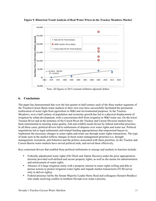
The match came in the form of series of interrelated events that took place in the city of Lemmon Valley,
just north of Reno. Changes to a large development proposal led the County to end up with a significant
portion of unused rights, which were put up to auction. There was little interest in the county’s excess
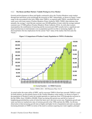
water rights until one large developer bid $18,000/AF (Erwin 2016). This one transaction set a precedent
for successive transactions and, as seen in Figure 4, average prices rose to $20,000 in 2005 and from there
to almost $30,000 in 2006. From there, the housing bubble crashed and the price decreased in subsequent
years.
Arguably, in a rapidly growing real estate market a policy of allowing (or requiring) developers to acquire
water rights in the open market and, thereby, to compete with the public water provider for available
water is not ideal. After decades of rapid development where irrigated lands were supplanted by sub-
divisions often without proper reservation and severing of the underlying appurtenant water rights, this
policy combined with the housing bubble not surprisingly led to a water rights bubble as well.
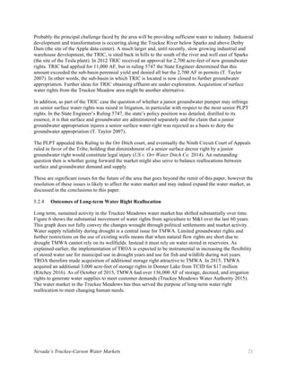
Current Market Status and Future Drivers5.2.3
As of 2016, the Truckee Meadows market is becalmed (Figure 5). There is little market activity and
current prices for permanent water right transfers in Truckee Meadows are in the $3,000-$3,500/AF
(Erwin 2016). This reflects the overhang of already permitted sub-divisions and will-serve commitments
from the housing bust in the late 2000s. In addition, population growth remains light and the demand for](https://image.slidesharecdn.com/3062c149-a03f-4b31-a522-65798e4ee5bf-170209003336/85/Nevada-Truckee-Springmeyer-Sanchez-25-320.jpg)