SlideShare a Scribd company logo
National Aeronautics and
                                                                                                        Space Administration
                                                                              Contacts


                                                                                                                                   marshall space flight center
                                                                       NASA MSFC Contacts

                                                                                Tim Corn
                                                                 Facilities Management Office Manager
                                                                              256–544–9451

                                                                            Charlotte Schrimsher
                                                                              Project Manager
                                                                                                        Facilities GIS &
                                                                               256–503–1610
                                                                                                        Data Integration
                                                                                Gary Rogers
                                                                             Technical Manager
                                                                               256–544–7955
Summary
The Facilities Management Office at NASA                        Intergraph Corporation Contacts
Marshall Space Flight Center maintains many
maps, databases, and CAD drawings for its                                       Ron Harlow
daily operations. However, these data sets are                               Executive Manager
independent from each other, and require specially                             256–730–1521
trained users with complex software to query and
report. A web application was developed using GIS                             Bill Mommsen
and SVG technologies to bring pertinent live data                            Program Manager
to the user’s desktop, without exhaustive training                            256–730–8179
or the installation of numerous applications. Now
decision makers at NASA are able to view maps                                  Roy Interrante
and architectural floor plans, obtain floor and room                         Technical Manager
information, find equipment, review maintenance                                757–515–5883
work orders, locate personnel, create color coded
floor plans, and many other functions from one
easy to use application.
                                                       National Aeronautics and Space Administration
                                                       George C. Marshall Space Flight Center
                                                       Huntsville, AL 35812

                                                       www.nasa.gov


                                                       NP-2007-05-70-MSFC
                                                       5-44319
Objectives                                               Approach                                                                                      Application (Continued)

The objectives of this application are to provide a      The core approach to the development of this web-                                             queries and reports are generated from a Center
web interface to Facilities Data, rapid data access, a   based Mapping, Interactive Floor Plan, and Data Portal                                        and Building perspective. The user can drill down
visual portal to multiple data sets, and be integrated   was to augment the decision-making capability of the                                          to more building information through the Interactive
in such a way that facilitates information gathering     Facilities Management Office’s existing data sets and                                         Floor Plan Application, where queries and reports
and analysis. This application makes business            their associated processes and applications. Each sub-                                        are generated from a floor and room perspective.
                                                         system was reviewed with the data maintenance staff                                           A Security Module was implemented in order to
                                                         and other data users to determine the best approaches                                         restrict access to sensitive data to specific users.
                                                         to access, report, and integrate data. The architecture                                       The application was built using a modular approach.
                                                         of this application is scalable, in order that new data                                       The modules include drawing and map navigation
                                                         access portals, components, functions, and applications                                       tools, web menu controls, map and floor plan
                                                         can be added in the future.                                                                   layer controls, search tools, database reports, etc.
                                                                                                                                                       Components can be added, removed, or modified,
                                                                                                                                                       depending on the customer’s requirements and the
                                                         Application                                                                                   structure of their databases.

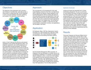
                                                         All Databases, Maps, CAD files, Applications, System
                                                         Processes, etc. were reviewed and a data flow model                                           Results
                                                         was developed. This model illustrates all linkages
                                                         and data flows of the existing information systems                                            Previously, Engineers and Decision Makers had to
                                                                                                                                                       contact many individuals to request data in order


                                                                                                                         Applications
                                                         user


                                                                                                                          Business
                                                                                                                                                       to gather necessary information. For example, they
                                                                                                             Map
                                                                                                            Layers


                                                         user
                                                                           Web Application
                                                                                                                                                       would contact the mapping department and request


                                                                                                                                        Applications
                                                                                                                                         Business
                                                                                                                       Environ-

                                                                           • GIS / Maps
                                                                                                                        mental
                                                                                                                                                       drawings of utility systems, aerials, and other maps,
sense, in that it improves the efficiency and decision   user
                                                                           • Data Portal                                                               then the Environmental department for locations of


                                                                                                                         Applications
                                                                                                                          Business
                                                                Security                     Integration    Maximo
                                                                Module     • Queries             Hub       Database

capabilities of the Facilities Management Office. This   user
                                                                           • Searches                                                                  monitoring wells and other concerns, then Asset
integration application uses existing databases and                        • Reports                                                                   Management for work orders and equipment


                                                                                                                                        Applications
                                                                                                                                         Business
                                                                                                                        Space
                                                                                                                      Management
                                                                           • Analysis
their associated business processes. The existing        user                                                                                          reports, then Space Management for color coded
applications have developed and evolved through the                                                                                                    floor plans, then the Planning Department, etc.


                                                                                                                         Applications
                                                                                                                          Business
                                                                                                            Floor
                                                                                                            Plans


years, and a significant amount of resources have been                                                                                                 Now Decision Makers can access all these data
invested. Instead of migrating these databases into                                                                                                    sets from their desktops and generate reports and
one central system, it was determined to leverage the    that the Facilities Management Office accesses. An                                            maps. Pertinent data can be viewed and analyzed
current systems by developing methods to integrate       Integration Hub was developed to correlate various non-                                       from new perspectives. Also, Data Managers can
data sets into one application. Current databases and    homogeneous databases. For example, by querying the                                           dedicate more time to building and improving the
business applications remain in place. Now users can     Maximo database to return a record set of all buildings                                       integrity and reliability of their databases.
retrieve about 80% of the common reports generated       to be replaced, and then joining the results to a GIS
by the current applications from this web portal.        database, a thematic map highlighting buildings to be
                                                         replaced is generated. The web application consists
                                                         of two major components: the Map and the Interactive
                                                         Floor Plan Applications. From the Map Application,

More Related Content

Similar to NASA MSFC Facilities GIS Brochure

Connected vehicle highway network applications
Connected vehicle highway network applicationsConnected vehicle highway network applications
Connected vehicle highway network applications
Texas Natural Resources Information System
 
CaseStudy_Harvard
CaseStudy_HarvardCaseStudy_Harvard
CaseStudy_Harvard
Robert Zannotti
 
TELUS Case Study: iVAULT implementation improved corporate intelligence
TELUS Case Study: iVAULT implementation improved corporate intelligence TELUS Case Study: iVAULT implementation improved corporate intelligence
TELUS Case Study: iVAULT implementation improved corporate intelligence
eventspat
 
TELUS Case Study: GIS for Telecommunications
TELUS Case Study: GIS for TelecommunicationsTELUS Case Study: GIS for Telecommunications
TELUS Case Study: GIS for Telecommunications
eventspat
 
Navy's GIS Solution for Decision Support and Service-wide Data-Sharing, Paper...
Navy's GIS Solution for Decision Support and Service-wide Data-Sharing, Paper...Navy's GIS Solution for Decision Support and Service-wide Data-Sharing, Paper...
Navy's GIS Solution for Decision Support and Service-wide Data-Sharing, Paper...
California Wildlife Conservation Board
 
William McGuyer GIS Analyst Resume 2015 newest
William McGuyer GIS Analyst Resume 2015 newestWilliam McGuyer GIS Analyst Resume 2015 newest
William McGuyer GIS Analyst Resume 2015 newest
Bill McGuyer
 
FieldTraks 2012 Product Overview
FieldTraks 2012   Product OverviewFieldTraks 2012   Product Overview
FieldTraks 2012 Product Overview
dbranson
 
GEMS_Article_PetroleumNews
GEMS_Article_PetroleumNewsGEMS_Article_PetroleumNews
GEMS_Article_PetroleumNews
Orlando McDowelle
 
Kafka Migration for Satellite Event Streaming Data | Eric Velte, ASRC Federal
Kafka Migration for Satellite Event Streaming Data | Eric Velte, ASRC FederalKafka Migration for Satellite Event Streaming Data | Eric Velte, ASRC Federal
Kafka Migration for Satellite Event Streaming Data | Eric Velte, ASRC Federal
HostedbyConfluent
 
An Energy Efficient Data Transmission and Aggregation of WSN using Data Proce...
An Energy Efficient Data Transmission and Aggregation of WSN using Data Proce...An Energy Efficient Data Transmission and Aggregation of WSN using Data Proce...
An Energy Efficient Data Transmission and Aggregation of WSN using Data Proce...
IRJET Journal
 
IRJET- Big Data Processes and Analysis using Hadoop Framework
IRJET- Big Data Processes and Analysis using Hadoop FrameworkIRJET- Big Data Processes and Analysis using Hadoop Framework
IRJET- Big Data Processes and Analysis using Hadoop Framework
IRJET Journal
 
Dejan Neskovic Resume
Dejan Neskovic ResumeDejan Neskovic Resume
Dejan Neskovic Resume
Dejan Neskovic
 
A Survey of Agent Based Pre-Processing and Knowledge Retrieval
A Survey of Agent Based Pre-Processing and Knowledge RetrievalA Survey of Agent Based Pre-Processing and Knowledge Retrieval
A Survey of Agent Based Pre-Processing and Knowledge Retrieval
IOSR Journals
 
World Pipelines - Better Together - SCADA and GIS
World Pipelines - Better Together - SCADA and GISWorld Pipelines - Better Together - SCADA and GIS
World Pipelines - Better Together - SCADA and GIS
smrobb
 
Pinnacle Financial Fourth Quarter Earnings Release
Pinnacle Financial Fourth Quarter Earnings ReleasePinnacle Financial Fourth Quarter Earnings Release
Pinnacle Financial Fourth Quarter Earnings Release
earningsreport
 
Advertisement jakarta walk_in_interview_published_nov_20_2011
Advertisement jakarta walk_in_interview_published_nov_20_2011Advertisement jakarta walk_in_interview_published_nov_20_2011
Advertisement jakarta walk_in_interview_published_nov_20_2011
Ade Herdiansah
 
Gisapplicationincivilengineering 140227110022-phpapp02
Gisapplicationincivilengineering 140227110022-phpapp02Gisapplicationincivilengineering 140227110022-phpapp02
Gisapplicationincivilengineering 140227110022-phpapp02
Antriksh Vatsyayana
 
William McGuyer 2015
William McGuyer 2015William McGuyer 2015
William McGuyer 2015
Bill McGuyer
 
Discovering Honolulu Data
Discovering Honolulu DataDiscovering Honolulu Data
A Survey on Data Mapping Strategy for data stored in the storage cloud 111
A Survey on Data Mapping Strategy for data stored in the storage cloud  111A Survey on Data Mapping Strategy for data stored in the storage cloud  111
A Survey on Data Mapping Strategy for data stored in the storage cloud 111
NavNeet KuMar
 

Similar to NASA MSFC Facilities GIS Brochure (20)

Connected vehicle highway network applications
Connected vehicle highway network applicationsConnected vehicle highway network applications
Connected vehicle highway network applications
 
CaseStudy_Harvard
CaseStudy_HarvardCaseStudy_Harvard
CaseStudy_Harvard
 
TELUS Case Study: iVAULT implementation improved corporate intelligence
TELUS Case Study: iVAULT implementation improved corporate intelligence TELUS Case Study: iVAULT implementation improved corporate intelligence
TELUS Case Study: iVAULT implementation improved corporate intelligence
 
TELUS Case Study: GIS for Telecommunications
TELUS Case Study: GIS for TelecommunicationsTELUS Case Study: GIS for Telecommunications
TELUS Case Study: GIS for Telecommunications
 
Navy's GIS Solution for Decision Support and Service-wide Data-Sharing, Paper...
Navy's GIS Solution for Decision Support and Service-wide Data-Sharing, Paper...Navy's GIS Solution for Decision Support and Service-wide Data-Sharing, Paper...
Navy's GIS Solution for Decision Support and Service-wide Data-Sharing, Paper...
 
William McGuyer GIS Analyst Resume 2015 newest
William McGuyer GIS Analyst Resume 2015 newestWilliam McGuyer GIS Analyst Resume 2015 newest
William McGuyer GIS Analyst Resume 2015 newest
 
FieldTraks 2012 Product Overview
FieldTraks 2012   Product OverviewFieldTraks 2012   Product Overview
FieldTraks 2012 Product Overview
 
GEMS_Article_PetroleumNews
GEMS_Article_PetroleumNewsGEMS_Article_PetroleumNews
GEMS_Article_PetroleumNews
 
Kafka Migration for Satellite Event Streaming Data | Eric Velte, ASRC Federal
Kafka Migration for Satellite Event Streaming Data | Eric Velte, ASRC FederalKafka Migration for Satellite Event Streaming Data | Eric Velte, ASRC Federal
Kafka Migration for Satellite Event Streaming Data | Eric Velte, ASRC Federal
 
An Energy Efficient Data Transmission and Aggregation of WSN using Data Proce...
An Energy Efficient Data Transmission and Aggregation of WSN using Data Proce...An Energy Efficient Data Transmission and Aggregation of WSN using Data Proce...
An Energy Efficient Data Transmission and Aggregation of WSN using Data Proce...
 
IRJET- Big Data Processes and Analysis using Hadoop Framework
IRJET- Big Data Processes and Analysis using Hadoop FrameworkIRJET- Big Data Processes and Analysis using Hadoop Framework
IRJET- Big Data Processes and Analysis using Hadoop Framework
 
Dejan Neskovic Resume
Dejan Neskovic ResumeDejan Neskovic Resume
Dejan Neskovic Resume
 
A Survey of Agent Based Pre-Processing and Knowledge Retrieval
A Survey of Agent Based Pre-Processing and Knowledge RetrievalA Survey of Agent Based Pre-Processing and Knowledge Retrieval
A Survey of Agent Based Pre-Processing and Knowledge Retrieval
 
World Pipelines - Better Together - SCADA and GIS
World Pipelines - Better Together - SCADA and GISWorld Pipelines - Better Together - SCADA and GIS
World Pipelines - Better Together - SCADA and GIS
 
Pinnacle Financial Fourth Quarter Earnings Release
Pinnacle Financial Fourth Quarter Earnings ReleasePinnacle Financial Fourth Quarter Earnings Release
Pinnacle Financial Fourth Quarter Earnings Release
 
Advertisement jakarta walk_in_interview_published_nov_20_2011
Advertisement jakarta walk_in_interview_published_nov_20_2011Advertisement jakarta walk_in_interview_published_nov_20_2011
Advertisement jakarta walk_in_interview_published_nov_20_2011
 
Gisapplicationincivilengineering 140227110022-phpapp02
Gisapplicationincivilengineering 140227110022-phpapp02Gisapplicationincivilengineering 140227110022-phpapp02
Gisapplicationincivilengineering 140227110022-phpapp02
 
William McGuyer 2015
William McGuyer 2015William McGuyer 2015
William McGuyer 2015
 
Discovering Honolulu Data
Discovering Honolulu DataDiscovering Honolulu Data
Discovering Honolulu Data
 
A Survey on Data Mapping Strategy for data stored in the storage cloud 111
A Survey on Data Mapping Strategy for data stored in the storage cloud  111A Survey on Data Mapping Strategy for data stored in the storage cloud  111
A Survey on Data Mapping Strategy for data stored in the storage cloud 111
 

NASA MSFC Facilities GIS Brochure

  • 1. National Aeronautics and Space Administration Contacts marshall space flight center NASA MSFC Contacts Tim Corn Facilities Management Office Manager 256–544–9451 Charlotte Schrimsher Project Manager Facilities GIS & 256–503–1610 Data Integration Gary Rogers Technical Manager 256–544–7955 Summary The Facilities Management Office at NASA Intergraph Corporation Contacts Marshall Space Flight Center maintains many maps, databases, and CAD drawings for its Ron Harlow daily operations. However, these data sets are Executive Manager independent from each other, and require specially 256–730–1521 trained users with complex software to query and report. A web application was developed using GIS Bill Mommsen and SVG technologies to bring pertinent live data Program Manager to the user’s desktop, without exhaustive training 256–730–8179 or the installation of numerous applications. Now decision makers at NASA are able to view maps Roy Interrante and architectural floor plans, obtain floor and room Technical Manager information, find equipment, review maintenance 757–515–5883 work orders, locate personnel, create color coded floor plans, and many other functions from one easy to use application. National Aeronautics and Space Administration George C. Marshall Space Flight Center Huntsville, AL 35812 www.nasa.gov NP-2007-05-70-MSFC 5-44319
  • 2. Objectives Approach Application (Continued) The objectives of this application are to provide a The core approach to the development of this web- queries and reports are generated from a Center web interface to Facilities Data, rapid data access, a based Mapping, Interactive Floor Plan, and Data Portal and Building perspective. The user can drill down visual portal to multiple data sets, and be integrated was to augment the decision-making capability of the to more building information through the Interactive in such a way that facilitates information gathering Facilities Management Office’s existing data sets and Floor Plan Application, where queries and reports and analysis. This application makes business their associated processes and applications. Each sub- are generated from a floor and room perspective. system was reviewed with the data maintenance staff A Security Module was implemented in order to and other data users to determine the best approaches restrict access to sensitive data to specific users. to access, report, and integrate data. The architecture The application was built using a modular approach. of this application is scalable, in order that new data The modules include drawing and map navigation access portals, components, functions, and applications tools, web menu controls, map and floor plan can be added in the future. layer controls, search tools, database reports, etc. Components can be added, removed, or modified, depending on the customer’s requirements and the Application structure of their databases. All Databases, Maps, CAD files, Applications, System Processes, etc. were reviewed and a data flow model Results was developed. This model illustrates all linkages and data flows of the existing information systems Previously, Engineers and Decision Makers had to contact many individuals to request data in order Applications user Business to gather necessary information. For example, they Map Layers user Web Application would contact the mapping department and request Applications Business Environ- • GIS / Maps mental drawings of utility systems, aerials, and other maps, sense, in that it improves the efficiency and decision user • Data Portal then the Environmental department for locations of Applications Business Security Integration Maximo Module • Queries Hub Database capabilities of the Facilities Management Office. This user • Searches monitoring wells and other concerns, then Asset integration application uses existing databases and • Reports Management for work orders and equipment Applications Business Space Management • Analysis their associated business processes. The existing user reports, then Space Management for color coded applications have developed and evolved through the floor plans, then the Planning Department, etc. Applications Business Floor Plans years, and a significant amount of resources have been Now Decision Makers can access all these data invested. Instead of migrating these databases into sets from their desktops and generate reports and one central system, it was determined to leverage the that the Facilities Management Office accesses. An maps. Pertinent data can be viewed and analyzed current systems by developing methods to integrate Integration Hub was developed to correlate various non- from new perspectives. Also, Data Managers can data sets into one application. Current databases and homogeneous databases. For example, by querying the dedicate more time to building and improving the business applications remain in place. Now users can Maximo database to return a record set of all buildings integrity and reliability of their databases. retrieve about 80% of the common reports generated to be replaced, and then joining the results to a GIS by the current applications from this web portal. database, a thematic map highlighting buildings to be replaced is generated. The web application consists of two major components: the Map and the Interactive Floor Plan Applications. From the Map Application,