Download to read offline


![!7
WATER RESOURCESRESEARCH,VOL. 28,NO. 4, PAGES 1095-1103,APRIL 1992
EnergyDissipation,RunoffProduction,and the Three-Dimensional
Structure of River Basins
IGNACIORODRfGUEZ-ITURBE,I,2ANDREARINALDO,3RICCARDORIGON,'*
RAFAELL. BRAS,2ALESSANDROMARANI,4 AND EDE IJJ/(Sz-VXSQUEZ2
Threeprinciplesof optimalenergyexpenditureare usedto derivethe mostimportantstructural
characteristicsobservedindrainagenetworks:(I) theprincipleofminimumenergyexpenditureinany
linkofthenetwork,(2)theprincipleofequalenergyexpenditureperunitareaof channelanywherein
the network,and(3) the principleof minimumtotal energyexpenditurein the networkas a whole.
Theirjoint applica,tionresultsin a unifiedpictureof themostimportantempiricalfactswhichhave
beenobservedin thedynamicsof thenetworkanditsthree-dimensionalstructure.They alsolink the
processof runoffproductionin thebasinwiththecharacteris.ticsof the network.
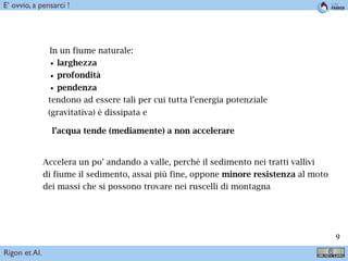
INTRODUCTION' THE CONNECTIVITY ISSUE
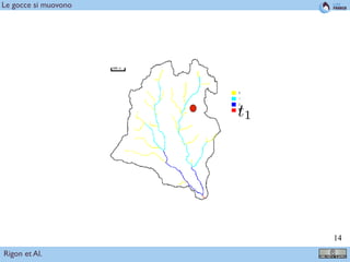
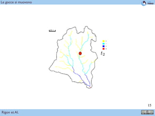
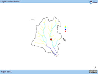
Well-developedriver basinsare made up of two interre-
latedsystems'the channelnetwork and the hillslopes.The
hillslopescontrolthe productionof runoffwhichin turn is
transportedthroughthe channelnetworktowardthe basin
outlet.Every branch of the network is linked to a down-
streambranchfor the transportation of water and sediment
butit is also linked for its viability, throughthe hillslope
system,toevery otherbranchin the basin.Hillslopesarethe
runoff-producingelements which. the n.etwork connects,
transformingthe spatially distributedpotential ,energyaris-
ingfromrainfallin the hillslopesto kineticenergyin theflow
throughthe channelreaches. In this paper we focuson the
drainagenetwork as it is controlled by energy dissipation
principles.It !spreciselytheneedfor effectiveconnectivity
thatleadsto the treelike structureof the drainagenetwork.
Figure!, from Stevens[1974], illustratesthis point. Assume
onewishestoconnectasetofpointsinaplanetoacommon
outletandfor illustrationpu.rposesassumethat everypoint
isequallydistantfrom its nearestneighbors.Two extreme
waystoestablishthe connectionwouldbe throughthe spiral
andtheexplosiontype of patterns.The explosionpattern
hastheadvantagethatit connectseveryparcelofthesystem
to the outlet in the most direct manner. Nevertheless it
.rejectsanykindof interactionbetweenthedifferentparts
andthe total path lengthfor the systemas a whole is
case each individualis supposedto operate at his best
completelyobliviousof his neighbors,but the systemas a
whole cannot survive.
Branchingpatterns accomplish connectivity combining
thebestof thetwo extremes;they are shortaswell asdirect.
The drainagenetwork, as well as many other natural con-
nectingpat.terns, is basically a transportationsygtemfor
which the treelike structure is a most appealing structure
from the point of view of efficiency in the construction,
operation and maintenance of the system.
The drainage network accomplishes connectivity for
transportationin three dimensions working against a resis-
tance force derived from the friction of the flow with the
bottomandbanksof the channels, the resistanceforce being
itself a function of the flow and the channel characteristics.
This makesthe analysisof the optimal connectivity a com-
plex problem that cannot be separated from the individual
optimalchannelconfigurationandfrom .thespatialcharac-
terization of the runoff production inside the basin. The
questionis whethertherearegeneralprinciplesthatrelate
thestructureof the network and its individualelementsWith
the rate of energy expenditure which takes place in the
systemas a whole and in each of its elements.
PRINCIPLESOF ENERGY EXPENDITURE
IN DRAINAG.ENETWORKS
1096 RODFffGUEZ-ITURBEET AL,' STRUCTUREOF DRAINAGE NETWORKS
233.1,•--303,3
L- 3.73
Fig. 1. Different patterns of connectivity of a set of equally
spacedpointstoa commonoutlet.L r isthetotallengthof thepaths,
andL is the averagelengthof the pathfrom a pointto the outlet. In
theexplosioncase,L•2)referstothecasewhenthereisaminimum
displacementamong the points so that there is a different path
betweeneachpoint and the outlet [from Stevens,1974].
network; (2) the principle of equal energy expenditureper
unit area of channel anywhere in the network; and (3) the
principleof minimumenergyexpenditurein the networkas
a whole. It will be shown that the combination of these
principlesis a sufficientexplanationfor the treelike structure
of the drainagenetwork and, moreover, that they explain
manyof themostimportantempiricalrelationshipsobserved
in the internal organizationof the network and its linkage
with the flow characteristics.The firstprincipleexpressesa
local optimal condition for any link of the network. The
secondprinciple expressesan optimal conditionthroughout
the network regardlessof its topologicalstructureand later
on in this paperwill be interpretedin a probabilisticframe-
work. It postulates that energy expenditure is the same
equalthesumofthecubesoftheradiiofthedaughter
vessels(see,forexample,Sherman[1981]).Heassumedthat
twoenergytermscontributetothecostofmaintainingblood
flowin anyvessel:(1) theenergyrequiredto overcome
frictionasdescribedbyPoiseuille'slaw,and(2)theenergy
metabolicallyinvolvedin the maintenanceof theblood
volumeandvesseltissue.Minimizationofthecostfuncfi0a
leadstotheradiusofthevesselbeingproportionaltothelB
powerof the flow. Uylings[1977]hasshownthatwhen
turbulentflowisassumedinthevessel,ratherthanlain'mar
conditions,thesameapproachleadstotheradiusbe'rag
proportionalto the 3/7 power of the flow. The secorot
principlewasconceptuallysuggestedbyLeopoldandLang.
bein[1962]in theirstudiesof landscapeevolution.It isof
interestto addthatminimumrate of workprincipleshave
been appliedin severalcontextsin geomorphicresearch.
Optimaljunctionangleshavebeenstudiedinthiscontextby
Howard[1971],Roy [1983],andWoldenbergandHorsfield
[1986],amongothers.Also the conceptof minimumworkas
a criterion for the developmentof streamnetworkshasbeen
discussedunder differentperspectivesby Yang[1971]a•d
Howard [1990], amongothers.
ENERGY EXPENDITURE AND OPTIMAL NETWORK
CONFIGURATION
Considera channelof width w, lengthL, slope$, andflow
depthd. The forceresponsiblefor theflowisthedownslope
componentof the weight, F1 = ptldLw sin /3 = ptIdLwS
where sin/3 = tan/3 = S. The force resistingthemovement
is the stressper unit area times the wetted perimeterarea,
F2 = •(2d + w)L, where a rectangularsectionhasbeen
assumed in the channel. Under conditions of no acceleration
of the flow, F1 = F 2, and then r = p.qSRwhereR isthe
hydraulicradiusR = Aw/Pw = wd/(2d + w), Awand
beingthe cross-sectionalflow area, andthewettedperimeter
ofthesection,respectively.In turbulentincompressibleflow
theboundaryshearstressvariesproportionallytothesqua•
oftheaveragevelocity,r = Cfpv2,whereCfisadimen.
sionlessresistancecoefficient.Equatingthetwoexpressions
for,, oneobtainsthewell-knownrelationship,S= Cfv2/
(R•/),whichgivesthelossesduetofrictionperunitweightof
flowperunitlengthofchannel.Thereisalsoanexpendi•
of energyrelatedto themaintenanceof thechannelw•ch
mayberepresentedby F(soil,flow)P•L whereF( ) isa
complicatedfunctionofsoilandflowpropertiesrepresenf•
theworkperunittimeandunitareaofchannelinvolved'm
theremovalandtransportationof thesedimentwhich0th-
erwise would accumulatein the channel surface.Fromthe
equationsofbedloadtransportonemayassumethatF =
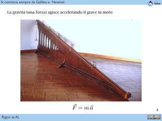
Perchè i fiumi hanno
questa forma, piuttosto
che le altre ?
Rigon et Al.
Bella domanda !](https://image.slidesharecdn.com/modelli-171022083807/85/Models-for-hazards-mapping-7-320.jpg)
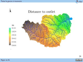

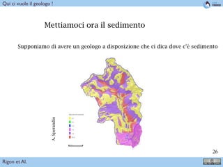
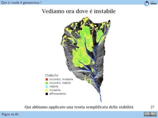
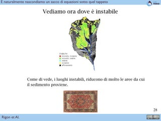


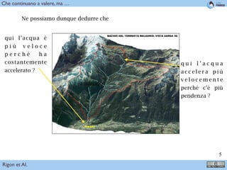
Il documento presenta un'analisi geologica del torrente Meledrio in Val di Sole, evidenziando la sua morfologia e le caratteristiche idrologiche. Viene descritto l'impatto della gravità e delle pendenze sul movimento dell'acqua, e si discutono i principi dell'espressione energetica nei sistemi di drenaggio. Inoltre, si menzionano le applicazioni pratiche e teoriche per comprendere la gestione delle risorse idriche e la stabilità del suolo.


