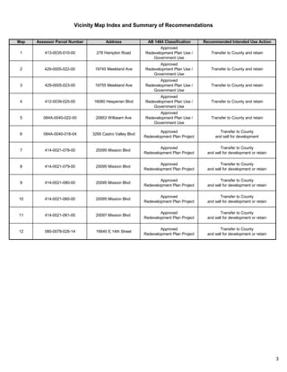
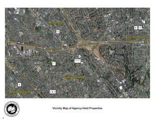
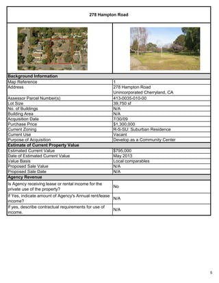
The document is a staff report recommending that the Oversight Board approve the Long-Range Property Management Plan (LRPMP) for the Successor Agency to the Former Redevelopment Agency of Alameda County. The LRPMP addresses 12 properties formerly owned by the redevelopment agency and intends for them to be transferred to Alameda County ownership according to their designated uses in approved redevelopment plans. Five properties are intended for public/government uses like a community center and fire station, while seven properties are intended to be sold for private development consistent with redevelopment plans.
PA-09-02 - County Initiated - Land Use Map Corrections & UpdatesCharles Andrews, AICP
This document summarizes a proposed ordinance to amend the Future Land Use Map of Manatee County, Florida. The amendment would change the land use designations of multiple privately and publicly owned parcels totaling approximately 610 acres. The changes aim to make the land use designations consistent with the current and planned uses of the parcels, including recognizing existing development. Privately owned parcels would be changed to designations matching their zoning. Publicly owned parcels used for conservation, utilities, recreation or institutional purposes would be changed to the Public/Semi-Public land use categories. The changes are intended to help the county qualify for a reduced flood insurance rate by limiting potential development in flood-prone areas.
This document summarizes the existing land use conditions along the proposed PG&E Jefferson-Martin transmission line project route. It describes the various jurisdictions the route will pass through, including San Mateo County, the San Francisco Public Utilities Commission Peninsula Watershed, Golden Gate National Recreation Area, and several cities. It also lists the general plan land use designations and existing land uses along the route.
Conception Planning Limited is seeking approval for a mixed-use development at 71 Plains Road East in Burlington. The proposal includes constructing a 713 square meter, two-storey building with eleven residential units on the second floor and two commercial units on the main level. A parking analysis determined that 24 parking spaces would be required and provided on site to meet zoning requirements. The development plan aims to blend with the surrounding neighborhood and enhance the community through new commercial and residential spaces. If approved, the development would redevelop a currently vacant property in accordance with applicable provincial, regional and municipal planning policies.
The document summarizes a request for an appeal of a previously approved Conditional Use allowing the sale of alcoholic beverages at a property located at 6005-6007 Knickerbocker Road in San Angelo. It provides background on the regulatory framework for Conditional Use requests and appeals, notifications received for the original request, photos of the property, an analysis of how the request meets criteria for approval, and a recommendation to affirm the Planning Commission's approval subject to conditions. It also summarizes a related request for a zone change from Neighborhood Commercial to General Commercial for the property.
This document summarizes a request to redevelop a 1.8 acre site containing vacant structures into a mixed-use development through a Planned Unit Development (PUD) overlay. The site is currently zoned Residential-Duplex-EightPlex and contains five vacant structures. The proposed PUD would allow uses including a homeless shelter, nursing home, offices, daycare and residential services. It details the applicant's development plan, surrounding land uses, compliance with zoning regulations and the city's comprehensive plan. City planning staff and commission recommend approving the PUD with conditions.
The document outlines the process for proposing and constructing the Kapiti Coast Expressway as part of the Wellington Northern Corridor. It discusses how the expressway was listed as a Road of National Significance, and the steps involved in designating the land, obtaining resource consents, protecting heritage sites, acquiring land, and establishing it as a limited access road. These steps include issuing a Notice of Requirement, public consultation, recommendations by local authorities, potential appeals to the Environment Court, and compensation for acquired or impacted private land. The multi-year process will require navigating the Resource Management Act, Public Works Act, Historic Places Act, and Government Roading Powers Act.
This 3 sentence summary provides the high level information from the document:
The document is an appendix that summarizes the mitigation and commitments documented in the body of the Final EIS for the Honolulu High-Capacity Transit Corridor Project. It describes 27 specific mitigation measures that will address issues related to safety and security, parking, relocations, acquisitions, and effects to community facilities from the project. The mitigation measures include plans, surveys, assistance for those affected, and restoration or replacement of impacted resources and property features.
This document summarizes a court case regarding a variance that was granted to allow a proposed 26-story hotel and residential tower project to encroach 74% into the coastal height setback in Waikiki, Hawaii. The city had established coastal height setbacks to protect views and the sense of open space along the shoreline. The developer, Kyo-ya, applied for a variance arguing it would be deprived reasonable use of its land without the variance. Kyo-ya also claimed the small and irregularly shaped parcel and historic building on site constituted unique circumstances. While opponents argued the project would alter the neighborhood's character, Kyo-ya maintained Waikiki was already densely developed and the project would be consistent with
The document summarizes the Red Hill Bay Shallow Water Habitat Restoration Project. It discusses the project overview, budget, permitting status, construction timeline, and technical details. The key points are:
1) The project will restore up to 640 acres of shorebird habitat at Red Hill Bay by building low berms and mixing pumped Alamo River water and Salton Sea water to a salinity of 25-40 ppt.
2) The total budget is $3.5 million provided by various funding sources including USFWS, IID, and state grants.
3) Construction is slated to begin in November 2016 and be complete by September 2017, with the new habitat operational by then.
The document announces a public meeting of the City Council of San Angelo, Texas to take place on June 7, 2011. The agenda includes consideration of various items such as approving meeting minutes and contracts, adopting ordinances, and holding public hearings on zoning changes and funding allocations. The meeting will be held at the McNease Convention Center and is accessible to persons with disabilities.
The City Council is considering two requests to change zoning designations in downtown San Angelo from General Commercial/Heavy Commercial to Central Business District. Planning staff and the Planning Commission recommend approving the zone changes. The Central Business District designation is more consistent with the development goals in the Comprehensive Plan to increase downtown's residential population and encourage redevelopment of historic structures while limiting heavy industrial uses. Approval would also maintain a contiguous Central Business District boundary.
The City Council document discusses three zone change requests:
1) A request to change the zoning of a property from Two-Family Residential to Low Rise Multi-family Residential to allow a church to operate. Public notifications received six objections.
2) A request to change the zoning of a vacant laundromat property from Single Family Residential to Neighborhood Commercial. No public comments were received.
3) A request by the school district to change the zoning of an elementary school property from Single Family Residential to High Rise Multi-Family Residential to allow for school expansion. Five public comments were received in support and none in opposition.
The document also discusses a proposal to expand the boundaries
The document is a public notice from the City of San Diego Development Services Department regarding the availability of a draft Environmental Impact Report for the proposed Stadium Reconstruction Project.
The draft EIR evaluates the environmental impacts of constructing a new multi-purpose sports stadium with seating for up to 68,000 people in the northeast corner of the existing Qualcomm Stadium site in Mission Valley.
The draft EIR found that the project would result in significant environmental impacts to air quality, biological resources, hazardous materials, historical resources, hydrology, land use, noise, paleontology, and neighborhood character. Mitigation measures are proposed to reduce some impacts but not to less than significant levels for all issue areas.
The notice provides information on
This document provides a regeneration masterplan for the redevelopment of the North Riverside area in Derby, England. It includes:
1) An overview of the site and surrounding area, including a brief history of development.
2) Details on planning policy and guidance for the redevelopment, including objectives to reduce flood risk, encourage investment, and enhance connectivity to the river.
3) Proposed plans and designs for the redevelopment, including creating new public spaces, improving transport links, and developing a mix of residential, commercial, and leisure spaces that celebrate the riverfront location.
This case involves a challenge to the County of Kauai Planning Commission's approval of a subdivision application by the Eric A. Knudsen Trust to develop land near Hapa Road in Koloa, Kauai. Theodore Blake filed a complaint asserting the defendants failed to follow proper environmental and historic review processes and violated Native Hawaiian rights. Blake later amended the complaint to add claims of negligence and public nuisance against the Knudsen Trust for breaching Hapa Road, which was discovered to be owned by the state, not the county. The circuit court dismissed the case, finding the issues were not ripe because the state had not approved breaching Hapa Road. The ICA affirmed. Blake appealed, arguing all claims were ripe
The document is a notification from the Haryana Government Town and Country Planning Department regarding the final development plan for 2021 A.D. for the controlled areas of Gual Pahari.
Some key details include:
- It proposes land uses and zoning regulations to guide development in the area which contains three villages - Gual Pahari, Balola, and Bandhwari.
- The plan allocates land for residential, transportation, public utilities, public/semi-public uses, open spaces, and a special economic zone.
- The area is characterized by hilly terrain and is proposed to be developed mainly for institutional uses like research institutes seeking a congenial environment near Delhi.
The City of New Smyrna Beach is proposing to rezone and change the comprehensive plan designations for 27.48 acres of land in the West Canal Street area. Staff analyzed 4 options for rezoning the area, including no change, rezoning the entire area to mixed-use, or splitting the area into mixed-use and neighborhood business or highway service business zones east and west of Myrtle Avenue. Staff recommended the Planning and Zoning Board approve one of the 4 options and make associated changes to the future land use map and zoning descriptions to avoid creating non-conforming uses.
The document is a draft environmental impact report (EIR) for the proposed Golden State Warriors Event Center project in San Francisco. Key aspects of the proposed project include:
- Construction of a multi-purpose event center to host Golden State Warriors games and other events on an 11-acre site.
- Associated mixed-use development including office, retail, open space, and parking structures.
- The event center building would be about 135 feet tall and include seating, restaurants, offices, and facilities to support events.
- Two 11-story (160 foot) office/retail buildings, retail spaces, three levels of parking with 950 spaces, and about 3.2 acres of open space including plazas
The Planning Commission received a request from the Department of Planning and Permitting to approve amendments to the Land Use Ordinance relating to interim planned development permits for transit-oriented development near future rail stations. The proposed amendments would create a new interim permit called the Interim Planned Development-Transit permit. This permit would provide flexibility from existing LUO regulations for development on lots within 1/4 mile of future rail stations. It would allow catalytic TOD projects to move forward before neighborhood TOD plans and development regulations are finalized. The permit process would be similar to other planned development permits and require City Council approval. Projects would be evaluated based on their economic, transportation, and community benefits. The amendments aim to facilitate creative rede
The request is to approve a zone change from Office Warehouse (OW) and General Commercial / Heavy Commercial (CG/CH) to General Commercial (CG) for three properties located at 226, 230, & 236 W 2nd Street in Central San Angelo. Eighteen notifications were sent and zero responses returned. Both the Planning Commission and City staff recommend approving the zone change.
The request is also to approve the release of a utilities easement along the north half of Red Bluff Circle in southwest San Angelo. The easement release was initiated by the Water Utilities Division. The properties are zoned Single-Family Residential and consist of residences. Both the Planning Commission and City staff recommend approving the easement release
The document discusses three requests for zone changes brought before the City Council. The first requests changing three vacant lots from Single-Family Residence to Neighborhood Commercial to match the zoning of neighboring businesses. The second requests changing part of two parks from Single-Family Residence to Central Business to better align the zoning boundary with the river. The third requests changing a mix of commercial and manufacturing zones to Central Business to expand the downtown area as suggested in the Comprehensive Plan. City staff and the Planning Commission recommend approving all three requests.
Mosman Parks & Bushland Association objection to Sydney Harbour Trust privati...savemiddlehead
Mosman Parks & Bushland Association Inc. objections to proposed amendments to Sydney Federation Harbour Trust Management Plan and development of a large residential aged care facility at Barracks and 10 Terminal sites on Middle Head, Sydney, published with permission Kate Eccles, Secretary Mosman Parks & Bushland Association Inc. December 2013. The Headland Preservation Group was merged into the Mosman Parks & Bushland Association after a long community campaign led by Linda Bergin OAM which resulted in the formation of the Sydney Harbour Federation Trust to protect the heritage and public land of Sydney Harbour sites.
California Coastal Commission revised staff report - Beach Chalet fieldsSFOceanEdge
This original Staff Report for the Beach Chalet presented the case for NOT approving the project. However, after intense political pressure was exerted on the Commission by leading California politicians, the report was rewritten to support destroying the environment at the end of Golden Gate Park and at Ocean Beach, San Francisco.
To learn more about this damaging project, go to www.sfoceanedge.org. Also view the video on youtube called Beach Chalet Fields Renovation, to see the beauty of this area that will be destroyed.
Be sure to download and read the full report. The crossed-out language is the original staff reporting, supporting protecting Golden Gate Park and Ocean Beach from over 7 acres of artificial turf and 150,000 watts of stadium lighting, that will be lighted until 10:00 pm every night of the year.
This short document promotes the creation of Haiku Deck presentations on SlideShare and encourages the reader to get started making their own presentation. It features photos credited to four different photographers and suggests that the reader may be inspired to create a Haiku Deck presentation after viewing samples from other creators.
Cristina Covelli is seeking a position in graphic design, marketing, or sales that allows her to contribute and develop her skills. She has experience as a Marketing Coordinator and Graphic Designer at Orion Hardware Corporation through an internship that led to full-time employment. She also has experience in sales roles at Oakley Vault and volunteer experience with the City of Toronto Parks and Recreation department. Cristina studied Advertising and Graphic Design at Humber College and has skills in programs like InDesign, Illustrator, and Photoshop.
This document discusses the opportunities and challenges of expanding a beekeeping operation from a hobby to a commercial business. It outlines typical stages a beekeeper goes through, from beginner to commercial operator. Key aspects of expansion include improving efficiency, understanding economics and honey bee biology, and determining the priority or purpose. The document also addresses acquiring equipment and bees, record keeping, apiary management, harvesting, extracting, marketing, and business structure considerations for expanded operations.
3E Consulting provides structural engineering and project management services in Cambodia and Germany, with over 7 years of experience. They specialize in reinforced concrete, steel design, foundation design, and structural detailing. Their services include structural analysis, design according to Eurocode standards, structural reports, and shop drawings. Recent projects include structural design of a jetty, service apartments, formwork, hotels, and a factory.
The document describes a Volume Revenue Mix (VRM) model implemented at Saputo Inc. to understand deviations from budgets and analyze the impact of volume, rate, and mix changes. VRM breaks down financial performance by looking at whether variance was from selling more/less units (volume), higher/lower prices (rate), or different product mix (mix). It provides an example comparing actual vs. budget performance and shows volume was lower but rate was higher, indicating mix changes impacted results. VRM is calculated monthly and stored in a data cube to allow flexible analysis and flag areas needing attention or justify pricing/portfolio decisions.
This resume summarizes the career experience of Lorraine A. Dold. She has over 30 years of experience in executive-level management of human service organizations, including positions as Chief Operating Officer, Director of Regional Operations, President/CEO, and Program Supervisor. Her experience includes managing daily operations, strategic planning, budgeting, staffing, program development, and community outreach in the areas of healthcare, disabilities services, early childhood education, and nonprofit management.
O documento descreve o mercado romano na antiguidade, discutindo o comércio do Império Romano como um setor importante da economia e as diferentes classes de pessoas envolvidas no comércio, como negociadores, mercadores, banqueiros e mascates.
Presentation during the Bureau of Agricultural Research (BAR) Seminar Series on September 27, 2016 at RDMIC Bldg., cor. Visayas Ave., Elliptical Rd., Diliman, Quezon City
Expanding your apiary by increasing the number of bee hives you keep. Discusses issues with multiple bee yards, or out yards. Discusses buying used equipment for sale.
The Chicago Plan Commission agenda for May 21, 2015 includes:
1) Consideration of resolutions to recommend ordinances authorizing the sale of several city-owned properties under the Adjacent Neighbors program and through negotiated sales.
2) Consideration of extending the tax increment financing district for the Read/Dunning Redevelopment Project Area.
3) Consideration of resolutions for the disposition and acquisition of properties related to a development by Lakeside Development.
4) Review of several zoning changes, planned developments, and special use applications, including for properties in the Lake Michigan shoreline protection district.
South Orange Valley and Third Street Redevelopment PlanAlex Torpey
This document summarizes the redevelopment plans for a 2.7 acre property located in the Village. A mixed-use development is proposed that would include approximately 521 space parking facility, 215 residential rental units (including affordable units), and 3,000 square feet of retail space. The development would be constructed by Jonathan Rose Companies and involves relocating the local rescue squad facility. Key aspects of the financial agreement, redevelopment plan, and anticipated development timetable are outlined.
This ordinance amends the City of DuPont's comprehensive plan, land use regulations, and zoning map regarding three areas: the civic center area, the mineral resource overlay, and the Fort Lake Business and Technology Park. It rezones 4.86 acres in the civic center area from residential to mixed use. It also amends elements and maps relating to the mineral resource overlay and the Fort Lake area to be consistent with requirements of the Washington State Growth Management Act. The ordinance was adopted after public hearings and consideration of exhibits outlining the amendments.
This ordinance amends the City of DuPont comprehensive plan, land use regulations, and zoning map regarding three areas: 1) The Civic Center Area, redesignating 4.86 acres from residential to mixed use. 2) The Mineral Resource Overlay. 3) The Fort Lake Business and Technology Park. The amendments went through public processes including workshops and hearings. The city council approved the amendments based on findings that they are consistent with goals of the comprehensive plan and state growth management laws.
The Riviera Beach Community Redevelopment Agency has identified three areas for immediate infill housing and redevelopment. These include: 1) the Avenue E area from 11th St to 23rd St, 2) the MLK Blvd area from Ave G to Australian Ave, and 3) the Old Dixie Hwy area from 1st St to 10th St. Within these areas, the CRA plans to invest in housing development, street improvements, and eliminating blight. Specific projects include constructing a bike path on Avenue E, widening SR 710, rehabilitating homes, and building a community garden and linear park. The CRA aims to acquire over $9 million in real estate and invest an additional $11 million to
The document outlines the history and development of the Hudson Yards project in New York City. It discusses how the project began with plans in the 1980s-1990s to redevelop the rail yards, followed by studies determining the need for rezoning and subway extension. A financing plan was created around 2002 that involved capturing tax revenues from new development. The rezoning and infrastructure work are now enabling over 25 million square feet of new commercial and residential space to be built, with over $11 billion already committed.
The letter provides a detailed objection to a planning application to develop land in Westcott, Surrey. It argues that approving the development would be premature for several reasons: 1) The site is designated as a reserve housing site and should not be developed until other suitable sites are exhausted; 2) There is no current housing deficit based on existing targets; 3) New housing targets set by the local council may be lower; 4) The location is less sustainable than other sites. It also argues the proposed density of housing is too high given site constraints.
2015 - Oakridge Transit Centre Policy StatementBen Johnson
This document provides a policy statement to guide redevelopment of the Oakridge Transit Centre site and three adjacent properties in Vancouver. It establishes a vision and guiding principles, and policies around land use, parks, transportation, built form, sustainability and community amenities. The policy statement considers how to plan for the future mix of uses, density, building design, public spaces and facilities to serve both new and existing communities on the sites.
Eric. E. Cavazza P.E., Director PA DEP Bureau of Abandoned Mine Reclamation -...Michael Hewitt, GISP
The document discusses Pennsylvania's AML Pilot Program which provides $30 million from 2016-2019 and $25 million in 2017-2018 to reclaim abandoned mine lands in the state. It provides details on 16 reclamation projects funded by the program, including remining sites, treating acid mine drainage, restoring mine-damaged land for parks and business development. The projects aim to improve environments and support economic development and community benefits like jobs, tourism, and improved infrastructure.
The document summarizes a request to rezone approximately 5 acres from Downtown Residential 1 and 2 districts to a Downtown Commercial General district. The rezoning would facilitate a more cohesive development for Denton Baptist Temple in the future. Staff recommends approval as the proposed rezoning conforms to the city's future land use plan and would permit a wider range of commercial uses compatible with the area along I-35E. The Planning and Zoning Commission previously approved the request by a vote of 5-0.
The City Council considered abandoning public rights-of-way around City Hall in downtown San Angelo, including portions of West 1st Street, North Irving Street, City Hall Plaza, and nearby alleyways and parking areas. No public comments were received in favor of or opposed to the abandonment. City staff recommended approving the abandonment subject to reserving easements for utility access. The abandonment would unify the area around City Hall and create a campus feel while remedying a dangerous intersection, in a way that is compatible with the city's comprehensive plan and existing land uses.
PA-06-07-52 The Loop Staff Report to BCC - Plan AmendmentSeann Smith, AICP
This petition seeks approval to amend the Future Land Use Map designation of 203 acres from Low Density Residential, Commercial Center, Commercial Corridor, and Low-Intensity Industrial to Mixed Use. The staff recommends transmitting the petition to the Department of Community Affairs with a recommendation of denial due to insufficient information provided by the applicant regarding impacts to the comprehensive plan and late material submissions. The Planning and Zoning Board voted to recommend transmittal with approval.
The document summarizes a preliminary investigation of the Rolling Knolls Landfill site to determine if it constitutes an "area in need of redevelopment" under New Jersey law. The landfill operated from the 1930s to 1968 and received various wastes. It is now a closed, unlined Superfund site with soil and groundwater contamination. The investigation finds the site demonstrates characteristics like contamination that qualify it for redevelopment area designation. This would allow the town to direct redevelopment and cleanup of the hazardous site.
This document summarizes a redevelopment opportunity in the Parramore neighborhood of Orlando that will involve combining three city- and CRA-owned properties totaling 6.06 acres into a single development. A selection process will be conducted to choose a developer to design and build a mixed-income development with affordable, supportive, and market-rate housing units along with community amenities. The project aims to create quality affordable housing, increase permanent supportive housing for the homeless, and stimulate revitalization in Parramore.
Applying For A Shoreline Use Permit / License At Lake Sidney LanierArthur Prescott
The document provides regulations and guidelines for shoreline use permits on Lake Lanier. It outlines that permits are required for any private facilities or work on public lands around the lake. Applications take 3 to 5 weeks to process and must include details like property information, site plans, and applicable fees. The U.S. Army Corps of Engineers manages the lake and permits are valid for 5 years, allowing only minor private facilities but no exclusive use of public areas.
Redistricting Application to include townhouses in a low density neighbourhoo...Janel Smith-Duguid
The document discusses a proposed bylaw to rezone a portion of land in Fort Saskatchewan from Urban Reserve District to Comprehensively Planned Residential District to allow for residential development. The proposed rezoning is consistent with statutory plans and would facilitate the next phase of the Southfort Meadows neighborhood. While some adjacent landowners expressed concerns about increased density and housing types, administration found the proposed rezoning complies with relevant policies regarding complete communities, housing diversity, and density targets. Administration recommended council approve second and third reading of the bylaw.
RFP for Reno's Community Assistance CenterThis Is Reno
Property appraisals completed in May for downtown Reno’s Community Assistance and Triage Centers (CAC) reveal that repairing the buildings to bring them back into service would cost an estimated $10.1 million—nearly four times the amount previously reported by city staff.
RFQ DRAFT for Qualified Development Teams 08-08brooke harris
This document is a request for qualified developers from the City of San Ramon Redevelopment Agency to develop an affordable family housing mixed-use development. It provides background on the agency's goals to maximize the development site for affordable housing and a mixed-use component. It also provides details on the city's demographics, current projects underway, median home prices, rental rates, the housing needs allocation, and area median incomes to help developers understand the local real estate market context.
Similar to Long Range Property Management Plan (20)
1. ALAMEDA COUNTY COMMUNITY DEVELOPMENT AGENCY
REDEVELOPMEDNT SUCCESSOR AGENCY
STAFF REPORT
TO: ALAMEDA COUNTY SUCCESSOR AGENCY OVERSIGHT BOARD
DATE: July 3, 2013
AGENDA ITEM: No. 7
Re: THE SUCCESSOR AGENCY’S LONG-RANGE PROPERTY MANAGEMENT PLAN
RECOMMENDATION
That the Oversight Board approve the Long-Range Property Management Plan.
DISCUSSION
The former Redevelopment Agency (RDA) was dissolved on February 1, 2012, pursuant to ABx1
26 (as amended by AB 1484). These Redevelopment Dissolution statutes govern the dissolution
of the RDA, which includes the disposition of its former real property.
Under ABx1 26, the Successor Agency was required to dispose of property acquired by the
former RDA “expeditiously”. This provision was amended significantly by AB 1484 to allow the
preparation of a Long-Range Property Management Plan (LRPMP). The LRPMP was one of
several benefits that accrued to Successor Agencies that made required payments under the
Due Diligence Reviews and achieved a Finding of Completion from the State Department of
Finance (DOF). The Alameda County Successor Agency received its Finding of Completion from
the DOF on April 26, 2013. The benefit that the LRPMP brings to the Successor Agency is the
ability to retain the properties for the redevelopment uses that they were acquired for, rather
than selling them quickly on the open market.
At the time of its dissolution, the former RDA owned twelve parcels of real property, which are
now owned by the Successor Agency, and are summarized below:
278 Hampton Road in Cherryland, to be used to construct a Cherryland Community
Center;
19745 and 19755 Meekland Avenue in Cherryland, treated as one site, for the
development of a fire station;
16080 Hesperian Boulevard in San Lorenzo (Lorenzo Theater) - requires major exterior
and interior renovation (once funding is identified), and then is expected to be operated
as a community cultural center, or run as a private enterprise;
20853 Wilbeam Avenue in Castro Valley, required as part of the construction of a
shared parking lot (already funded) with other adjacent private sites;
3295 Castro Valley Boulevard in Castro Valley, to be sold, renovated and leased for new
retail/commercial uses;
2. 2
20095 and 20097 Mission Boulevard in Cherryland (two addresses covering five
separate parcels) to be either sold for new private development, or developed by the
County; and
16640 E14th Street in Ashland, to be either sold for new private development, or
developed by the County.
The LRPMP is organized to provide specific information for each property, as required by Health
and Safety Code Section 34191.5. This organization generally includes the following information
for each parcel: background information; an estimate of current value; information about
revenue being generated from the property; environmental site information; previous
development proposals; community benefit; transit oriented development potential;
advancement of Successor Agency objectives; and the recommended action.
The LRPMP addresses how each of the twelve properties is needed to implement projects
identified in the Redevelopment Plan, and how the uses detailed in the LRPMP will achieve
goals, objectives and policies of the Redevelopment Plan and the Five Year Implementation
Plan. Health and Safety Code Section 34191.5 (c) (2) (A) states that if the LRPMP directs the use
or liquidation of the property for a project identified in an approved redevelopment plan, the
property shall transfer to the county. The twelve properties are eligible for, and staff
recommends, the transfer to the County for disposition and use in accordance with the LRPMP.
The LRPMP accords with the descriptions above of the twelve properties; it recommends that
once the properties are transferred to the County, five of the parcels remain in County
ownership for planned public uses, and seven parcels be sold pursuant to the LRPMP as
intended by the former RDA.
The Health and Safety Code Section (34191.5) that governs the preparation of the LRPMP is
silent as to the use of the proceeds from the sale of property that has been transferred to the
County under this section. However, our outside counsel (Goldfarb & Lipman) has advised that
by applying Health and Safety Code Section 34191.5 (c) (2) (A) to retain the properties for
projects in an approved redevelopment plan, the resulting proceeds from the sale of these
properties must also be used for projects identified in an approved redevelopment plan.
The Successor Agency is schedule to approve the LRPMP at its June 25, 2013 meeting. If the
Oversight Board also approves the LRPMP, then staff will forward it to the DOF for its approval.
Upon approval of the LRPMP by the DOF, the twelve properties will transfer from the Successor
Agency to the County and held in a Community Redevelopment Property Trust Fund, for
disposal or use as planned in the LRPMP.
ECONOMIC AND FISCAL IMPACT
If the DOF approves the LRPMP, proceeds from the sale of properties not being retained for a
governmental use will be used to fund projects identified in the Redevelopment Plans.
Expenditure of these funds will require future Board approval.
4. Alameda County Successor Agency
Long-Range Property Management Plan
Table of Contents
Executive Summary 1
Vicinity Map Index and Summary of Recommendations 3
Vicinity Map of Agency-Held Properties 4
Agency-Held Properties
278 Hampton Road 5
19745 and 19755 Meekland Avenue 7
16080 Hesperian Boulevard 9
20853 Wilbeam Avenue 11
3295 Castro Valley Boulevard 13
20095 and 20097 Mission Boulevard 16
16640 East 14th
Street 19
5. 1
Alameda County Successor Agency
Long-Range Property Management Plan
Executive Summary
The Successor Agency to the Former Redevelopment Agency of Alameda County
received its Finding of Completion (FOC) under AB 1484 from the California
Department of Finance (DOF) on April 26, 2013. Upon approval of the Long-Range
Property Management Plan (the “LRPMP”), the subject properties are to be transferred
from the Successor Agency to Alameda County and held in a Community
Redevelopment Property Trust Fund by the County.
This LRPMP contains the State required information for the twelve (12) parcels formerly
owned by the County of Alameda Redevelopment Agency. All properties are located in
unincorporated Alameda County and are summarized in a Vicinity Map Index. All
twelve properties were acquired and remain intended for “Approved Redevelopment
Plan Uses” as identified in their respective Redevelopment Plans and the Five Year
Implementation Plan.
Five properties were acquired, and are to be developed for public use. These include:
• 278 Hampton Road in Cherryland, to be used to construct a Cherryland
Community Center;
• 19745 and 19755 Meekland Avenue in Cherryland, treated as one site for the
development of a fire station;
• 16080 Hesperian Boulevard in San Lorenzo (Lorenzo Theater), once funding is
identified requires major exterior and interior renovation, and then is to be
operated as a community cultural center, or run as a private enterprise; and
• 20853 Wilbeam Avenue in Castro Valley, required as part of the construction of a
funded, shared parking lot with other adjacent private sites, and managed
privately.
Seven properties were acquired and are to be sold to and developed by private
enterprise, or retained and developed by the County, for approved Redevelopment Plan
uses. These include:
• 3295 Castro Valley Boulevard in Castro Valley, to be sold, renovated and leased
for new retail/commercial uses;
• 20095 and 20097 Mission Boulevard in Cherryland (two addresses cover five
separate parcels) to be either sold for new private development, or developed by
the County. Due to low commercial rents in the area and high construction costs,
unsubsidized, landlord/tenant private development may not be feasible. Staff is
examining and currently marketing for other potential uses such as owner user or
non-profit commercial and/or mixed use development proposals. Interim
temporary uses may also be viable until a permanent development proposal is
secured; and
6. 2
• 16640 E14th Street in Ashland to be either sold for new private development, or
developed by the County. Due to low commercial rents in the area and high
construction costs, unsubsidized, landlord/tenant private development may not
be feasible. Staff is examining and currently marketing for other potential such
as owner user or non-profit commercial and/or mixed use development
proposals. Interim temporary uses may also be viable until a permanent
development proposal is secured.
Proceeds of any subject property sales will be retained by the County and used in
accordance with “Approved Redevelopment Plan Uses” to further the goals of the Plan
and economic development in Alameda County’s unincorporated areas. Such uses
may include but are not limited to the identified projects in the Redevelopment Plans
and the Five Year Implementation Plan, investment in one of the remaining projects in
this LRPMP, maintenance for LRPMP properties, code enforcement, graffiti removal,
and façade improvement loans.
7. Vicinity Map Index and Summary of Recommendations
3
Map Assessor Parcel Number Address AB 1484 Classification Recommended Intended Use Action
1 413-0035-010-00 278 Hampton Road
Approved
Redevelopment Plan Use /
Government Use
Transfer to County and retain
2 429-0005-022-00 19745 Meekland Ave
Approved
Redevelopment Plan Use /
Government Use
Transfer to County and retain
3 429-0005-023-00 19755 Meekland Ave
Approved
Redevelopment Plan Use /
Government Use
Transfer to County and retain
4 412-0039-025-00 16080 Hesperian Blvd
Approved
Redevelopment Plan Use /
Government Use
Transfer to County and retain
5 084A-0040-022-00 20853 Wilbeam Ave
Approved
Redevelopment Plan Use /
Government Use
Transfer to County and retain
6 084A-0040-018-04 3295 Castro Valley Blvd
Approved
Redevelopment Plan Project
Transfer to County
and sell for development
7 414-0021-078-00 20095 Mission Blvd
Approved
Redevelopment Plan Project
Transfer to County
and sell for development or retain
8 414-0021-079-00 20095 Mission Blvd
Approved
Redevelopment Plan Project
Transfer to County
and sell for development or retain
9 414-0021-080-00 20095 Mission Blvd
Approved
Redevelopment Plan Project
Transfer to County
and sell for development or retain
10 414-0021-060-00 20095 Mission Blvd
Approved
Redevelopment Plan Project
Transfer to County
and sell for development or retain
11 414-0021-061-00 20097 Mission Blvd
Approved
Redevelopment Plan Project
Transfer to County
and sell for development or retain
12 080-0078-026-14 16640 E.14th Street
Approved
Redevelopment Plan Project
Transfer to County
and sell for development or retain
9. 5
No
N/A
N/A
Date of Estimated Current Value May 2013
Local comparables
N/A
N/A
Proposed Sale Value
Proposed Sale Date
Is Agency receiving lease or rental income for the
private use of the property?
If Yes, indicate amount of Agency's Annual rent/lease
income?
If yes, describe contractual requirements for use of
income.
Value Basis
Agency Revenue
Develop as a Community Center
39,750 sf
1
278 Hampton Road
Unincorporated Cherryland, CA
413-0035-010-00
R-S-SU: Suburban Residence
Vacant
$795,000Estimated Current Value
Lot Size
Assessor Parcel Number(s)
Current Zoning
Current Use
Acquisition Date
Purchase Price
Purpose of Acquisition
Estimate of Current Property Value
$1,300,000
7/30/09
No. of Buildings N/A
Building Area N/A
Address
278 Hampton Road
Background Information
Map Reference
10. 6
AB 1484 / Recommended action:
Approved Redevelopment Plan Project / Government
Use as a community center.
Describe potential Community Benefit The development of a community center serving
unincorporated Cherryland is a long standing community
goal and was the highest priority Redevelopment project
for the former Cherryland Redevelopment Citizens
Advisory Committee.
Describe the property's potential for transit
oriented development
Low. While the site is centrally located within the
unincorporated community of Cherryland, it is not directly
served by bus or BART.
Describe the reuse potential of the property in
terms of advancing the Successor's Agency's
planning objectives
The project is identified as a neighborhood infrastructure
goal in the Five Year Implementation Plan for FY 9/10 –
13/14, approved June 30, 2009.
The Redevelopment Plan for Eden Area Redevelopment
Project, adopted 7/11/00, Section II.A. “Development in
Project Area”, pg 7, says, “”Provide new or improved
community facilities such as fire stations, …..recreational
facilities, community centers and libraries…”
278 Hampton Road
Environmental History of Contamination / Remediation
LCM/ACM (Lead Containing Material / Asbestos
Containing Material) analysis was performed in July,
2009 prior to demolition of barn on site; no lead based
paint or asbestos was found on or surrounding the barn;
barn demolished in Fall 2009. Phase I analysis was
performed in July, 2009 for the entire site (haz mat &
hydrocarbons); nothing found; soil testing recommended
prior to redevelopment to check for pesticides given
former agricultural use.
Reuse Assessment and Recommended Action
Have any environmental tests or assessments
been preformed on the property?
This property was acquired expressly for the purpose of
constructing a community center.
Previous Development Proposals
Describe any previously proposed or solicited
development plans for the property, including
any short term and or long term lease/rental
arrangements.
11. 7
Proposed Sale Value N/A
Proposed Sale Date
May 2013
Local comparables
No
19745 and 19755 Meekland Avenue
If yes, describe contractual requirements for use of
income.
Value Basis
19745 Meekland Ave. - $401,800
19755 Meekland Ave. - $430,460
Proposed use is a County Fire Station.
Agency Revenue
N/A
Estimate of Current Property Value
Current Zoning: R-S-D-3, Suburban Residence
Vacant
Is Agency receiving lease or rental income for the
private use of the property?
If Yes, indicate amount of Agency's Annual rent/lease
income?
19745 Meekland Ave. - $ 200,000
19755 Meekland Ave. - $ 199,900
N/A
Estimated Current Value
Current Use
19745 Meekland Ave. - Sept. 7, 2010
19755 Meekland Ave. - November 15, 2010
2 and 3
19745 and 19755 Meekland Avenue
Unincorporated Cherryland, CA
429-0005-022-00 and 429-0005-023-00
19745 Meekland Ave. - 20,090 sf
19755 Meekland Ave. - 21,523 sf
Acquisition Date
Purchase Price
Purpose of Acquisition
Building Area 19745 Meekland Ave. - 1,075 sf
19755 Meekland Ave. - 1,841 sf
Current Zoning
N/A
Date of Estimated Current Value
Background Information
Map Reference
No. of Buildings 19745 Meekland Ave. - 1
19755 Meekland Ave. - 1
Address
Lot Size
Assessor Parcel Number(s)
12. 8
19745 and 19755 Meekland Avenue
This property was acquired expressly for the purpose of
constructing a County Fire Station.
Previous Development Proposals
Describe any previously proposed or solicited
development plans for the property, including
any short term and or long term lease/rental
arrangements.
Environmental History of Contamination / Remediation
Have any environmental tests or assessments
been preformed on the property?
Phase I analysis in July 2010 for both properties (haz
mat & hydrocarbons); nothing found upon visual
inspection; nothing found in historical records.
LCM/ACM (Lead Containing Material / Asbestos
Containing Material) testing recommended prior to
demolition due to age of buildings; visible signs of mold;
further testing recommended; soil testing recommended
prior to redevelopment.
Describe the reuse potential of the property in
terms of advancing the Successor's Agency's
planning objectives
The project is identified as a neighborhood infrastructure
goal in the Five Year Implementation Plan for FY 9/10 –
13/14, approved June 30, 2009.
The Redevelopment Plan for Eden Area Redevelopment
Project, adopted 7/11/00, Section II.A. “Development in
Project Area”, pg 7, says, “”Provide new or improved
community facilities such as fire stations, sheriff
stations….”
Section III.F.2. “Redevelopment Implementation,
Cherryland Sub-Area”, pg 27 says, “Retrofit/replace fire
facilities.”
AB 1484 / Recommended action: Approved Redevelopment Plan Use / Government Use
as a County Fire Station.
Reuse Assessment and Recommended Action
Describe potential Community Benefit Proposed use is Fire Station and may include a
Community Health Clinic. The existing fire station
serving Cherryland has structural/seismic issues and
needs a replacement facility.
Describe the property's potential for transit
oriented development
Low. While the site is centrally located within the
unincorporated community of Cherryland, it is not directly
served by bus or BART.
13. 9
Agency Revenue
Estimate of Current Property Value
No
N/A
N/A
Proposed Sale Value N/A
Proposed Sale Date N/A
Is Agency receiving lease or rental income for the
private use of the property?
If Yes, indicate amount of Agency's Annual rent/lease
income?
If yes, describe contractual requirements for use of
income.
Local land comparables less demo, environmental
review, and interior art preservation.
Develop as community cultural center.
Value Basis
May 2013
$0Estimated Current Value
Date of Estimated Current Value
Purpose of Acquisition
412-0039-025-00
HP, Historic Preservation District
Vacant
$415,000
1/29/10
13,424 sf
1
9,700 sf
Assessor Parcel Number(s)
Current Zoning
Current Use
Acquisition Date
Purchase Price
Lot Size
No. of Buildings
Building Area
Address
16080 Hesperian Boulevard
Background Information
Map Reference 4
16080 Hesperian Boulevard
Unincorporated San Lorenzo, CA
14. 10
Describe the reuse potential of the property in
terms of advancing the Successor's Agency's
planning objectives
The project is identified as an economic development
goal in the Five Year Implementation Plan for FY 9/10 –
13/14, approved June 30, 2009.
The Redevelopment Plan for Eden Area Redevelopment
Project, adopted 7/11/00, Section II.A. “Development in
Project Area”, pg 7, says, “”Provide new or improved
community facilities such as fire stations,…..recreational
facilities, community centers …”
Section III.F.5., “Redevelopment Implementation, San
Lorenzo Sub-Area”, pg 33 says, “Provide and/or expand
community facilities, including the library, parks,
community centers and fire stations.”
Section III.G.3, “Rehabilitation and Conservation of
Structures – Buildings of Historical Significance and
Other Cultural, Historic or Scenic Resources”, pg 33,
says, “To the extend practical, special consideration shall
be given to the protection, rehabilitation, or restoration of
any structure determined to be historically significant,
taking into consideration State and County guidelines.”
AB 1484 / Recommended action: Approved Redevelopment Plan Project / Government
Use.
Reuse Assessment and Recommended Action
Describe potential Community Benefit Reuse of this historic former movie theatre is a high
priority for the San Lorenzo community.
Describe the property's potential for transit
oriented development
Low. Although the site is along a major traffic corridor
and is serviced by AC Transit bus routes #97, 85 and S,
it is small for residential development.
16080 Hesperian Boulevard
Proposals have been offered for renovation as a
pub/movie theater and or community performance space.
However, extensive staff research indicates renovation
of this property is extremely expensive and not
economically feasible for the private market. Sizable
subsidy is needed to accomplish the capital renovation,
and interior art preservation, with additional subsidy
needed for long term operations. It may ultimately be
operated by either a public or private entity.
Previous Development Proposals
Describe any previously proposed or solicited
development plans for the property, including
any short term and or long term lease/rental
arrangements.
Environmental History of Contamination / Remediation
Have any environmental tests or assessments
been preformed on the property?
LCM/ACM (Lead Containing Material / Asbestos
Containing Material) analysis was performed in August,
2010; asbestos found in the roof; roof was abated and re-
roofed. Other parts of the building were not tested but
due to the age, it is assumed that asbestos will be found
elsewhere. Lead based exterior paint requires
abatement or encapsulation in place. Phase I analysis
not completed.
15. 11
If Yes, indicate amount of Agency's Annual rent/lease
income?
N/A
May 2013
Value Basis Local comparables
N/A
N/A
Is Agency receiving lease or rental income for the
private use of the property?
Proposed Sale Value
Proposed Sale Date
If yes, describe contractual requirements for use of
income.
N/A
No
Date of Estimated Current Value
Agency Revenue
084A-0040-022-00
Castro Valley Central Business District Specific
Plan, Sub Area 11, High Density Residential Uses
Vacant
Address
20853 Wilbeam Avenue
Background Information
Map Reference 5
20853 Wilbeam Avenue
Unincorporated Castro Valley, CA
Assessor Parcel Number(s)
Current Zoning
Current Use
Acquisition Date
Purchase Price
No. of Buildings
Building Area
$180,000
Develop as a Shared Parking Lot in conjunction
with property #6 below. “Agreement Establishing
Reciprocal Easements for Shared Parking and
Access and Providing for Joint Use and
Maintenance” is pending signature by Alameda
County and 3 private parties as of June 1, 2013.
7,200 sf
N/A
N/A
Estimate of Current Property Value
Lot Size
Purpose of Acquisition
Estimated Current Value
$675,305
5/1/09
16. 12
20853 Wilbeam Avenue
Describe the reuse potential of the property in
terms of advancing the Successor's Agency's
planning objectives
The project is identified as an economic development
goal in the Five Year Implementation Plan for FY 9/10 –
13/14, approved June 30, 2009.
The Redevelopment Plan for Eden Area Redevelopment
Project, adopted 7/11/00, Section II.A. “Development in
Project Area”, pg 6, says, ““…encourage the better
utilization of Real Property, and a more efficient and
effective circulation system….
Section III.F.1., “Redevelopment Implementation, Castro
Valley Sub-Area”, pg 24 says, “Encourage the assembly
of oddly-shaped parcels in business districts to
encourage standard development.” Pg 25 says, “Assist
individual property owners in resolving cross lot drainage
problems.”
AB 1484 / Recommended action: Approved Redevelopment Project / Government Use.
Reuse Assessment and Recommended Action
Describe potential Community Benefit Consolidates four separate private parking areas into
one destination lot in downtown Castro Valley’s central
business district.
Describe the property's potential for transit
oriented development
Low. Property is to be used in conjunction with property
#6 below, and three other private commercial parcels, to
construct a Shared Parking Lot facility, all located three
blocks from the Castro Valley BART station and on AC
Transit’s #32 bus line.
Shared Parking Lot
A Memorandum of Understanding (MOU) has been
drafted and reviewed by all private parties and its
execution is imminent. Architectural plans have been
prepared for submittal to the Planning Dept.
Environmental pre-development (CEQA) analysis is
being prepared now for submission to the Planning Dept.
Previous Development Proposals
Describe any previously proposed or solicited
development plans for the property, including
any short term and or long term lease/rental
arrangements.
Environmental History of Contamination / Remediation
Have any environmental tests or assessments
been preformed on the property?
LCM/ACM (Lead Containing Material / Asbestos
Containing Material) analysis was performed in August,
2009; lead based paint found in exterior; abated.
Asbestos found in counter top sheeting; abated. Building
demolished in 2009.
17. 13
Agency Revenue
$2,797,000
4/8/11
$30,000 via temporary lease, August - October, 2011.
$35,000 via temporary lease, August – October, 2012.
$35,000 via temporary lease, August – October, 2013.
Planned 2013 Temporary Lease to be heard by the
Oversight Board July, 2013.
None
Value Basis Appraisal
Proposed Sale Value TBD
Proposed Sale Date Spring 2014
Is Agency receiving lease or rental income for the
private use of the property?
If Yes, indicate amount of Agency's Annual rent/lease
income?
1
Building Area 24,375 sf
Date of Estimated Current Value Jan 8, 2013
Estimated Current Value
Purpose of Acquisition
Address
3295 Castro Valley Boulevard
Background Information
Map Reference 6
3295 Castro Valley Boulevard
Unincorporated Castro Valley, CA
084A-0040-018-04
Castro Valley Central Business District Specific
Plan, Sub Area 7, Intensive Retail with Offices
and High Density Residential allowed to rear or
upper stories
Vacant
If yes, describe contractual requirements for use of
income.
$950,000
Yes
Approved Redevelopment Plan Project with full
building renovation or reconstruction, and new
retail/commercial occupancy.
Estimate of Current Property Value
Assessor Parcel Number(s)
Current Zoning
Current Use
Acquisition Date
Purchase Price
Lot Size 44,900 sf
No. of Buildings
18. 14
3295 Castro Valley Boulevard
Property has been actively marketed since acquisition,
both via an RFP process and wide informal solicitations.
A leading candidate was identified in June, 2012. A
Disposition and Development Agreement is currently
being drafted and negotiated, in anticipation of Long
Range Property Management Plan Approval. This site is
intended to be developed in conjunction with the Shared
Parking Lot property as described under 20853 Wilbeam
Avenue (map reference #5).
Previous Development Proposals
Describe any previously proposed or solicited
development plans for the property, including
any short term and or long term lease/rental
arrangements.
Environmental History of Contamination / Remediation
Have any environmental tests or assessments
been preformed on the property?
In August, 2010 asbestos was found in the roof; roof was abated and
re-roofed. Other parts of the building were not tested but due to the
age, it is assumed that asbestos will be found elsewhere.
Phase I Analysis was completed in September, 2010 for
hydrocarbons, soil contamination, water contamination and
LCM/ACM (Lead Containing Material / Asbestos Containing Material).
Lead based paint has not been tested for, but based on the age of
the building expected to be found at minimum on exterior paint.
Abatement or encapsulation will be necessary. Further testing
needed. Asbestos containing materials exist in building although
some abatement has been done since 1996. Abatement or
encapsulation will be necessary. Further testing needed. Hydraulic
piston freight elevator has the potential to have leaked into building
and surrounding soil, or may in the future. Property includes a
foundation dewatering system which pumps water directly into the
storm drain system. See Phase II below.
Phase II Analysis (Limited investigation report) was completed
October 2010; soil gas sampling; soil and grab ground water
sampling; sump pump water sampling; testing determined the ground
table water to be contaminated, likely from historical up-gradient dry
cleaning solvents; permit from State Regional Water Quality Control
Board (RWQCB) obtained; pretreatment system for sump pump
water installed in 2011. Water testing within acceptable range,
continues to be monitored on a quarterly basis and reported to
RWQCB.
19. 15
3295 Castro Valley Boulevard
AB 1484 / Recommended action: Approved Redevelopment Plan Project; future use is sale
to and development by private enterprise.
Reuse Assessment and Recommended Action
Describe the property's potential for transit
oriented development
Low. Property is to be used in conjunction with the 20853
Wilbeam Avenue property, and three other private
commercial parcels, to construct a Shared Parking Lot
facility, all located three blocks from the Castro Valley
BART station and on AC Transit’s #32 bus line.
Describe the reuse potential of the property in
terms of advancing the Successor's Agency's
planning objectives
The project is identified as an economic development
goal in the Five Year Implementation Plan for FY 9/10 –
13/14, approved June 30, 2009.
The Redevelopment Plan for Eden Area Redevelopment
Project, adopted 7/11/00, Section II.A. “Development in
Project Area”, pg 6, says, “Encourage development
according to the General Plan”, and “Encourage
investment in the Project Area by the private sector”, and
“Encourage and expand shopping facilities in the Project
Area by encouraging the development of new
commercial uses and the rehabilitation of existing
commercial uses …” Pg 7 says, “Enhance and expand
shopping facilities in the Project Area by encouraging the
development of new commercial uses…
Section III.F.1., “Redevelopment Implementation, Castro
Valley Sub-Area”, pg 24 says, “Develop a downtown
Castro Valley revitalization strategy”, and “Implement a
business recruitment and retention program.”
Describe potential Community Benefit Conveying to a developer or commercial user will realize
a key redevelopment objective of infill retail development
at a long dormant property in a central business district
location.
20. 16
Approved Redevelopment Plan Project;
Future use is sale to and development by private
enterprise, or retention and development by
County, either for approved Redevelopment Plan
uses.
Purpose of Acquisition
No. of Buildings N/A
Building Area N/A
414-0021-060-00:
Ashland and Cherryland Business Districts Specific Plan, TA
(Transit Access), retail, office or higher density residential.
414-0021-061-00, 414-0021-078-00,
414-0021-079-00,& 414-0021-080-00:
Ashland and Cherryland Business Districts Specific Plan, FA
(Freeway Access), large scale, general land uses.
Vacant
414-0021-060-00 & 414-0021-061-00: $2,350,000
414-0021-078-00,
414-0021-079-00,
414-0021-080-00: $1,890,000
414-0021-060-00 & 414-0021-061-00: 12/12/2008
414-0021-078-00,
414-0021-079-00,
414-0021-080-00: 12/03/2008
Current Zoning
Current Use
Acquisition Date
Purchase Price
20095 and 20097 Mission Boulevard
Background Information
Map Reference 7-11
Address
Lot Size 414-0021-060-00 - 9,026 sf
414-0021-061-00 - 46,704 sf
414-0021-078-00 - 36,677 sf
414-0021-079-00 - 14,700 sf
414-0021-080-00 - 7,650 sf
Total - 114,757 sf
20095 and 20097 Mission Boulevard
Unincorporated Cherryland, CA
20095 Mission Boulevard:
414-0021-060-00,
414-0021-078-00,
414-0021-079-00,
414-0021-080-00.
20097 Mission Boulevard:
414-0021-061-00
Assessor Parcel Number(s)
21. 17
20095 and 20097 Mission Boulevard
Estimate of Current Property Value
Property has been actively marketed since acquisition using
widespread informal solicitations by staff. Until a permanent
development occurs, a variety of interim uses have been
proposed and may be pursued for temporary use, all of which
are commercial and/or community uses and are Approved
Redevelopment Plan Projects: community center, produce
stand, educational gardening site, and other retail.
Previous Development Proposals
Describe any previously proposed or solicited
development plans for the property, including
any short term and or long term lease/rental
arrangements.
Environmental History of Contamination / Remediation
Have any environmental tests or assessments
been preformed on the property?
History of contamination/remediation:
Phase 1 report was completed in September 2003. Historical
use as an automotive repair center and inclusion of an
oil/water separator on site as well as other hydraulic lifts and
Above Ground Storage Tanks (ASTs) recommends further
testing to confirm groundwater and soil seepage.
Underground Storage Tanks were removed and files closed
out in 1998. ACM and LCP were anticipated to be found on
the property, but no testing was completed as part of the
Phase 1 report. Adjacent electrical sub-station owned by
PG&E may contain transformers with PCBs.
Used Car Sales Building ACM and LCP report completed in
February 2009; materials abated in 2009. Showroom
Building: Asbestos Containing Material (ACM) and Lead
Containing Paint (LCP) report completed in March 2009;
materials abated in 2009; building demolished in September
2009. Old PGE Building: ACM and LCP report completed
May 2010; materials abated in 2011; building demolished in
2011.
Agency Revenue
Estimated Current Value $2,295,140 - Total of 5 parcels
Date of Estimated Current Value May 2013
Value Basis Appraisal of APN 414-0021-060
on 4/26/11 = $270,000, approx $30/sf.
Appraisal of APN 414-0021-061
on 4/26/2011 = $1,120,000, approx $24/sf.
Local Comparables
Proposed Sale Value TBD
If yes, describe contractual requirements for
use of income.
No
Proposed Sale Date TBD
Is Agency receiving lease or rental income for
the private use of the property? No
If Yes, indicate amount of Agency's Annual
rent/lease income?
N/A
22. 18
20095 and 20097 Mission Boulevard
AB 1484 / Recommended action: Approved Redevelopment Plan Project; future use is sale
to and development by private enterprise, or retention
and development by County, either for approved
Redevelopment Plan Project.
Reuse Assessment and Recommended Action
Describe the property's potential for transit
oriented development
High. The sites are in a Priority Development Area (PDA)
at an intersection of major traffic corridors, as well as on
AC Transit’s bus routes #801, 99 and 93, and are
equidistant between 2 Bay Area Rapid Transit (BART)
stations, Bayfair and Downtown Hayward.
Describe the reuse potential of the property in
terms of advancing the Successor's Agency's
planning objectives
The project is identified as an economic development goal in the Five
Year Implementation Plan for FY 9/10 – 13/14, approved June 30,
2009.
The Redevelopment Plan for the Alameda County – City of San
Leandro Redevelopment Project, adopted June 1993, Section I.A.8.,
“Introduction – Purposes and Objectives”, page 2 says, “Acquire real
property and encourage consolidation of parcels.”
Section I.A.10., pg 2 says, ”Encourage the redevelopment of the
Project Area through the cooperation of private enterprise and public
agencies.”
Section IV.A.2., “Proposed Development Actions”, page 3 says, “In
appropriate cases, rehabilitation of structures and improvements or
development of vacant land by present owners, their successors and
the Agency/County for uses in accordance with this Plan….”
Section IV.A.3, pg 4 says, “Redevelopment of land by private
enterprise or public agencies for uses in accordance with this Plan…”
Section IV.A.4., pg 4 says, “Construction and improvement of
recreation facilities, community facilities, parking facilities and other
public facilities”
Section IV.A.7., pg 4 says, “Acquisition and disposition of property
acquired for uses in accordance with this Plan.”
Describe potential Community Benefit Conveying to a developer or commercial user will realize
a key redevelopment objective of infill retail development
on a high traffic corridor with several vacant parcels
nearby. Development is intended to be a catalyst and
trigger other private re-use projects in the vicinity.
23. 19
38,363 sf
Estimated Current Value $580,000
Date of Estimated Current Value October 25, 2012
Future use is sale to and development by private
enterprise, or retention and development by
County, either for approved Redevelopment Plan
uses.
Purpose of Acquisition
Agency Revenue
$1,080,0000
Proposed Sale Value
Proposed Sale Date
TBD
TBD
Estimate of Current Property Value
Value Basis Appraisal, October 25, 2012
If yes, describe contractual requirements for use of
income.
NoIs Agency receiving lease or rental income for the
private use of the property?
If Yes, indicate amount of Agency's Annual rent/lease
income?
N/A
N/A
16640 East 14th Street
Background Information
Map Reference 12
16640 East 14th Street
Unincorporated Ashland, CA
080-0078-026-14Assessor Parcel Number(s)
Current Zoning
Current Use
Acquisition Date
Purchase Price
No. of Buildings
Building Area
Ashland and Cherryland Business District Specific
Plan, TA (Transit Access), retail, office or higher
density residential
Approved Redevelopment Plan Use: License
Agreement for temporary parking for nearby
County facility is pending as of June 1, 2013.
March 17, 2010
Address
N/A
N/A
Lot Size
24. 20
16640 East 14th Street
Property has been actively marketed since acquisition
using widespread informal solicitations by staff. A Buyer
has not yet been secured. Until a permanent
development occurs, an interim use for temporary
parking for a nearby government building has been
proposed and is currently under consideration. Other
retail/commercial interim uses may be proposed and
pursued: produce stand, and other informal retail.
Previous Development Proposals
Describe any previously proposed or solicited
development plans for the property, including
any short term and or long term lease/rental
arrangements.
Environmental History of Contamination / Remediation
Have any environmental tests or assessments
been preformed on the property?
Phase 1 report was completed in November, 2009. Due to
historical use as an automobile maintenance facility and the
inclusion of an oil/water separator on site, further soil and
groundwater testing was recommended to determine whether
or not petroleum hydrocarbons, metals, and Volatile Organic
Compounds have been released. It was determined that the
building contained suspect ACM and LCP in its construction
materials and that further testing and abatement would be
needed prior to demolition.
Phase 2 report was completed in February, 2010.
Contaminants were tested for and determined to be below the
allowable limits. No abatement or further testing necessary. It
was recommended that the oil/water separator be contained
and removed from the property.
LCM/ACM (Lead Containing Material / Asbestos Containing
Material) analysis was performed in February 2010. Lead
based paint found on metal barrier poles surrounding
property. Asbestos found throughout interior of building;
abated. Oil/water separator removed, hazardous materials
abated and building demolished in 2010.
One former drain line must be removed with any new site
preparation for a development project.
25. 21
16640 East 14th Street
AB 1484 / Recommended action: Approved Redevelopment Plan Project; future use is sale
to and development by private enterprise, or retention
and development by County, either for approved
Redevelopment Plan Project.
Describe the property's potential for transit
oriented development
High. The site is in a Priority Development Area (PDA)
along a major traffic corridor and serviced by AC
Transit’s bus routes #801, 99 and 93, and is less than 1
mile from the Bayfair BART station.
Reuse Assessment and Recommended Action
Describe potential Community Benefit Conveying to a developer or commercial user will realize
a key redevelopment objective of infill retail development
on a high traffic corridor with several underutilized
parcels nearby. Development is intended to be a
catalyst and trigger other private re-use projects in the
vicinity.
Describe the reuse potential of the property in
terms of advancing the Successor's Agency's
planning objectives
The project is identified as an economic development goal in
the Five Year Implementation Plan for FY 9/10 – 13/14,
approved June 30, 2009.
The Redevelopment Plan for the Alameda County – City of
San Leandro Redevelopment Project, adopted June 1993,
Section I.A.10., “Introduction – Purposes and Objectives”,
page 2 says, ”Encourage the redevelopment of the Project
Area through the cooperation of private enterprise and public
agencies.”
Section IV.A.2., “Proposed Development Actions”, page 3
says, “In appropriate cases, rehabilitation of structures and
improvements or development of vacant land by present
owners, their successors and the Agency/County for uses in
accordance with this Plan….”
Section IV.A.3, pg 4 says, “Redevelopment of land by private
enterprise or public agencies for uses in accordance with this
Plan…”
Section IV.A.4., pg 4 says, “Construction and improvement of
recreation facilities, community facilities, parking facilities and
other public facilities”
Section IV.A.7., pg 4 says, “Acquisition and disposition of
property acquired for uses in accordance with this Plan.”