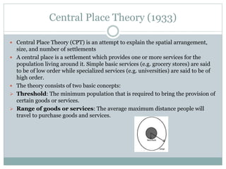
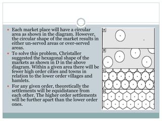
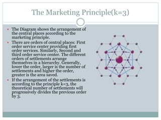
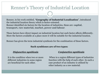
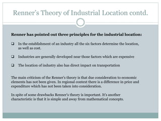
1. The document discusses various location theories proposed by Alfred Weber, Hotelling, Christaller, Hoover, Losch, and Isard.
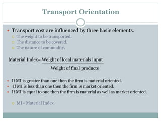
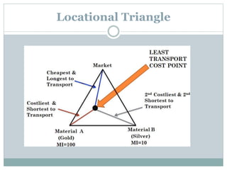
2. Weber's location theory from 1909 proposed that firms choose locations where costs are lowest, considering factors like raw material costs, transportation costs, and labor costs.
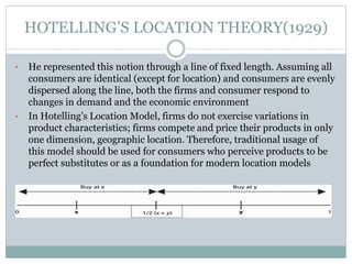
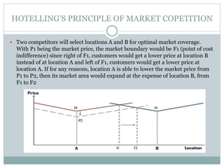
3. Hotelling's location theory from 1929 examined how two competing firms on a linear city would choose locations to maximize market coverage.
Theories and models for Regional planning and developmentKamlesh Kumar
This is a work on the major theories of Regional planning mainly consisting the work of Francois Perroux, Gunnar Myrdal, Albert O. Hirschman, Walter Whitman Rostow and John Friedman.
the major theories of industrial location were developed by the economists. some of them which we consider pioneering and useful in understanding the locational behaviour of firm are explained here.
Two major theories namely :(1) Weber's Theory. (2) The market area theory of Tord Palander.
The Growth Pole Theory proposes that economic development does not occur uniformly across a region, but rather concentrates around specific industrial "poles" or clusters. As key industries in these poles expand, they stimulate linked industries and drive regional growth outward from the pole through inter-industry linkages and multiplier effects. Three factors that contribute to growth pole development are external economies of scale, industrial agglomeration, and forward and backward production linkages between industries. While influential, the Growth Pole Theory has been criticized for not addressing problems like urban poverty and income inequality within regions.
Von thunen’s model of agricultural land useThe Urban Unit
This presentation is based on a agricultural land use model around the city. This is the theory of urban Geography it describe the agricultural pattern and how should the agricultural activities perform around the city. basically this Model was put forwarded before industrialization and when there was no roads networks and this Model is not applicable in real word but is gives great ideas for developing new towns and cities.
I’m professional presentation maker . These presentations are for sale for 20$ each, if required you can contact me on my gmail id bestpptmaker@gmail.com and you can also suggest me topics for your required presentations
Von thunen theory of agricultural land useWESLEY MELI
Von Thunen's model of agricultural land use proposes that the type of agriculture in concentric zones around a central market city is determined by the transportation costs of different agricultural products. The model suggests that dairy farming and intensive agriculture will occur in the innermost zone due to high transportation costs for perishable products. Timber and firewood production is next as wood is heavy. Extensive grain farming is in the third zone as grains have lower transport costs. Ranching is in the outermost zone as livestock are self-transporting and have the lowest transport costs. The model aims to explain the balance between land costs and transportation in determining agricultural location patterns.
- August Losch published his central place theory in 1940, attempting to explain the spatial arrangement, size, and number of settlements.
- He based the theory on assumptions including an isotropic surface, constant supply of goods, evenly distributed population, and that demand decreases with distance from production centers.
- The theory simplified the world to a flat plain with circular market areas that eventually form a hexagonal pattern as more producers enter the market and compete for profits.
- The theory was criticized for being too abstract and simplistic in its treatment of demand and locational interdependence. Empirical studies did not always match the predicted patterns.
This document discusses different types of regions and methods for delineating regions. There are three main types of regions: formal, functional, and perceptual/vernacular. Formal regions have officially defined boundaries, functional regions are defined by economic or other processes within them, and perceptual regions reflect cultural attitudes. Methods for delineating regions include weighted index numbers, factor analysis, flow analysis and gravitational analysis. These methods group areas based on shared characteristics like socioeconomic factors or the intensity of interactions between locations.
There are four main theories of industrial location:
1) Weber's (1909) least cost theory, which states that industries locate where transportation costs of raw materials and finished products are minimized. This depends on whether the industry is weight gaining or weight losing.
2) Hotelling's (1929) theory of locational interdependence, which examines how demand impacts location as competitors try to capture market share in their locations.
3) Losch's (1939) theory of demand-oriented location, which focused on maximizing access to markets for finished goods.
4) Smith and Pred's (1971) profit-maximization theory examining how firms locate based on profit considerations.
The document discusses the growth pole theory introduced by French economist Francis Perroux. The theory proposes that economic growth does not occur uniformly across a region, but rather concentrates around specific poles or points of growth. A growth pole is defined as a central location of economic activity that ignites growth and improves quality of life in surrounding areas. The document provides examples of Vallabh Vidyanagar and Ankleshwar in India which developed from educational and industrial growth poles respectively, attracting new economic clusters and population agglomerations around the initial primary poles.
Central place theory attempts to explain the spatial distribution and hierarchy of settlements. It was first presented by German geographer Walter Christaller in 1933 based on a study in southern Germany. The theory proposes that settlements form a hierarchy based on the goods and services provided, with higher order settlements further apart and providing more specialized functions. Central place theory is based on the concepts of threshold, the minimum population needed to support a service, and range, the maximum distance people will travel to access a service. Christaller suggested settlements would form hexagonal market areas in an ideal scenario. However, the theory makes simplifying assumptions and the perfect patterns are not seen in reality.
This document provides an overview and assessment of growth pole theory. It discusses the origins of the theory with Francois Perroux in the 1950s. It describes key concepts such as propulsive industries, backward and forward linkages, and the polarization of space. The theory gained popularity in the mid-20th century but also received criticisms for failing to differentiate between natural and artificial growth poles. The document also discusses later evolutions of the theory by scholars like Boudeville to incorporate regional implications and the importance of knowledge spillovers and innovation in modern growth poles.
Regional planning is important for several reasons including addressing cultural differences, urbanization challenges, and economic issues between regions. There are two main approaches to regional planning: intra-regional which focuses on land use and meeting needs within a region, and inter-regional which aims to balance economic growth, employment, and development between regions. Examples of regional planning in Kenya include the 1978 Human Settlement Strategy and the Kenya Vision 2030 development framework. In summary, regional planning plays a significant role in country development by taking approaches between and within regions at an intermediate level between national and local plans.
This slide discusses about the core-periphery model given by John Friedmann. This model is basically a model of regional Development. You will able to learn about the core-periphery model very easily by this slide.
The document discusses regional planning and central place theory. It defines a region as an area with homogeneous characteristics that make it suitable for administrative purposes. Central place theory examines the distribution and hierarchy of settlements that provide goods and services. Key elements include central goods/places and their complementary hinterlands. The theory assumes an even distribution of population and resources and aims to minimize transportation costs. Central places form hexagonal market areas to efficiently divide space and serve consumers. Regional planning deals with infrastructure development across large multi-jurisdictional areas based on their functional relationships and characteristics.
Regional planning deals with efficient placement of land uses like farmland, cities, infrastructure, and wilderness across a larger area than individual towns. A region requires various land uses to support protection of farmland, cities, industry, transportation, and other needs. Regional development addresses region-wide environmental, social and economic issues through efficient infrastructure placement and zoning to sustainably grow a region.
Levels, Patterns and Trends of Urbanization (World)ShreemoyeeSaha1
1. What is Urbanization?
2. Levels of Urbanization in the World
3. Patterns of Urbanization in the World : Demographic Changes, Economic Development, Consumption Pattern, Urban Footprint.
4. Patterns of Urbanization in Asia.
5. Trends of Urbanization in the World : Past, Recent and Future Trends.
6. Timeline of Urbanization in the World (1950- 2050)
7. Projected Urban and Rural Population.
8. Urbanization and Sustainability.
The Weber model of industrial location uses transportation costs to predict where industries will locate. It assumes firms face no risks and have identical production costs everywhere. Raw materials can be ubiquitous and found everywhere or localized in certain areas.
Weber developed diagrams to show least cost locations. A straight line diagram shows the location when one raw material is localized and one is ubiquitous. A triangular diagram shows when two raw materials are localized. Isotims represent lines of equal transportation costs, while isodapanes connect points of equal total transportation costs to determine the overall least cost location. Agglomeration economies, or savings from locating near other firms, are also considered.
The document discusses different types of industry and factors that influence industrial location. It covers primary, secondary, tertiary and quaternary industries. Key factors in industrial location include availability of raw materials, labor supply, markets, transportation access, capital, energy sources, and government policies. Location theories aim to maximize profits and minimize costs by considering these various economic and transportation factors. Theories discussed include Weber's least-cost model and the concept of agglomeration economies.
The document summarizes Economic Base Theory, which proposes that a region's economic growth is determined by increases in exports from that region. It states that the theory divides an economy into basic and non-basic sectors, with the basic sector comprising activities that bring money in from outside the region through exports or preventing imports. It provides examples of basic and non-basic sectors and outlines assumptions of the theory, including that the export sector drives local growth and all activities fit into basic or non-basic categories. It also defines and provides an example of how the base multiplier is used to estimate a basic sector's impact on the local economy.
The concept of growth foci is one of the indispensable strategies for the regional development, which can be applied for the transformation of socio-economic activities of rural and urban settlements.
The growth foci have been identified with the help of certain indicators of administration, communication, education, health, finance, recreation, market and others.
This document discusses backward regional development plans in India. It begins by outlining the need to identify backward regions to target development efforts. Several national committees are mentioned that developed criteria and methods to delineate backward areas based on factors like income, infrastructure, employment levels etc. Principal methods used include calculating development indices for districts and ranking them. The Backward Area Grant Fund was launched to direct financial resources towards the 250 most backward districts to strengthen local governance and infrastructure. Case studies of state-level plans for backward areas are also referenced.
Settlement geography is a branch of human geography that deals with how human populations are distributed on Earth and how settlements form and change over time. It examines characteristics like population size, layout, functions, and relationship to the surrounding environment. Originally focused on describing existing settlement patterns, the field has evolved to use remote sensing and modeling to analyze changes and plan more sustainable development. Settlement geography considers factors influencing where and how people first formed settlements and how they have expanded, as well as issues around rapid urbanization and strategies for improving rural and urban livability. While its scope has adapted over time, the core focus remains understanding the physical attributes of settlements and their interactions with social and environmental conditions.
This document summarizes Weber's theory of industrial location, which proposes that firms will seek to locate production in areas with the lowest costs. Weber identified three main cost factors that influence a firm's location decision: transport costs, labor costs, and agglomeration economies. Transport costs depend on the weight and distance of goods transported as well as the type of commodity. Labor costs can vary based on wage rates and efficiency levels between locations. Agglomeration refers to cost advantages from concentrating similar industries together. The theory has been criticized for oversimplifying factors like transport costs and assuming fixed labor and market locations.
The primary aim of studying settlement geography is to acquaint with the spatial and structural characteristics of human settlements under varied environmental conditions.
Von Thunen published his theory of agricultural land use patterns in 1826 in his book "The Isolated State". The theory was based on an isolated region with homogeneous climate and soil quality where the only mode of transportation was by foot. It proposed that there would be concentric zones of land use radiating from the city center based on transport costs and product perishability. Dairy farming would be in the innermost zone due to high transport costs of perishable products, followed by zones for forestry, vegetables, and grazing further from the city. The bid rent curve showed the relationship between economic rent and distance from the market. While pioneering, the theory was based on unrealistic assumptions and had limitations in applying to contemporary systems
Central Place Theory proposes that settlements are arranged in a hierarchy based on their provision of goods and services. It assumes an even distribution of resources, population, and transportation costs. Central places provide market areas for goods and services, with higher-order settlements offering a wider range of goods and services to larger market areas. The theory outlines three principles: the marketing principle minimizes the number of settlements; the transportation principle minimizes road lengths; and the administrative principle ensures smaller market areas are enclosed within larger ones. Central Place Theory provides a framework for understanding urban hierarchies and has been applied to market planning and development projects, though its assumptions do not always reflect real-world conditions.
The document discusses geographical economics and its application to South Africa. It provides an overview of theories that attempted to explain the location of economic activity before geographical economics, including urban economics, regional economics, and trade theory. It then outlines Krugman's core model of geographical economics, which incorporates economies of scale and imperfect competition. The document also discusses evidence from South Africa on topics like growth and convergence across regions, the role of cities, and how geography affects exporters and firms.
1. The document discusses several theories of industrial location including Weber's model, Bid Rent theory, and Losch's market area analysis.
2. Weber's model proposes that industries locate based on minimizing costs of transportation, labor, and agglomeration. Bid Rent theory explains how land values decline with distance from the central business district due to increasing transportation costs.
3. Losch's market area analysis focuses on maximizing sales volume and profit by locating within the range of the market demand cone centered around population centers.
The document discusses three major theories of industrial location: Weber's theory, Sargent Florence's theory, and August Losch's theory. Weber's theory focuses on minimizing costs as the primary factor for location, considering transportation and labor costs. Sargent Florence introduced coefficients to measure industry concentration and localization. August Losch's theory incorporated demand factors and argued that industries locate based on access to the largest markets. The document provides an overview of the key aspects and criticisms of each theory.
This paper develops a model of trade driven by economies of scale at the firm level, rather than differences in technology or endowments. With internal scale economies, markets exhibit monopolistic competition. The model shows that trade and gains from trade can occur between identical countries. Growth increases welfare by raising real wages and variety. Opening trade between identical countries has the same effect as growth, increasing scale, variety, and welfare in both places through balanced trade. Factor mobility acts as a substitute for trade.
This document presents a theory of international trade in tasks developed by Gene M. Grossman and Esteban Rossi-Hansberg. The theory models production as a continuum of tasks that can be performed either domestically or offshored to foreign countries. It analyzes how reductions in the costs of offshoring tasks affect wages and prices in the source country. The authors develop a decomposition of the effects of offshoring costs on wages, identifying a productivity effect, relative price effect, and labor supply effect. They show that the productivity effect, which stems from cost savings when offshoring tasks, typically benefits the factor whose tasks are more easily moved offshore.
The document discusses the trade-off theory of urban land use, which was proposed in the 1950s in response to traffic congestion. It was further developed in the 1960s-1970s by economists who related land use patterns to transportation systems. The theory uses bid rent curves to show how households trade off access and space based on income, minimizing costs of commuting. Land values are highest near the urban center and decrease with distance, influenced by transportation costs and demand for space.
This research begins by showing the different meanings attributed to the term cluster by different currents and authors, which suggests definitions that are found around its spatial framework. Next, the factors that intervene in the competitiveness of a region and its growth are shown, for the development of these, Porter’s model of competitiveness which was taken as reference, and the contexts: geographical and economic. Therefore, the methodology was used based on a qualitative design, with descriptive and correlational scope since it will analyze differences of each cluster, with respect to the factors of dimensions, establishments, growth, economic impact and policies. To do this, the information-gathering tool was two semi-structured interviews with cluster leaders in both countries, because the approach is based on data collection methods that are not completely standardized or predetermined. And finally, the results of the comparison of the Mexican Bajío automotive cluster with the German cluster located in Baden-Württemberg are presented.
1) The entry of a second firm in a differentiated market may harm consumers by increasing prices and potentially decreasing consumer surplus.
2) When a second firm enters, the first firm repositions itself. Under certain conditions, the duopoly price can exceed the monopoly price despite increased variety from the second firm.
3) For linear transportation costs, prices always increase with entry. Consumer surplus decreases for some parameter values and remains the same for others.
Social welfare is maximum in case of imperfect competitionAkeeb Siddiqui
There are two main approaches to welfare economics: the early neoclassical approach and the new welfare economics approach. The early approach assumes cardinal utility can be measured, while the new approach uses ordinal utility and Pareto efficiency. Perfect competition occurs when many small buyers and sellers trade homogeneous goods, while imperfect competition arises when firms have some control over prices through monopolies, oligopolies, or natural monopolies sanctioned by governments. Imperfectly competitive markets can result in inefficiencies like deadweight loss compared to perfectly competitive markets.
This document provides an overview of Central Place Theory, which was developed by German geographer Walter Christaller to explain the spatial arrangement of settlements. The key points are:
- Central Place Theory models the hierarchy and spacing of settlements based on their provision of goods and services to surrounding populations. Christaller proposed three principles (marketing, transportation, administrative) to explain the patterns.
- Threshold population and goods/services range determine the lower and upper limits of central places. Assumptions include evenly distributed population/resources and equal transportation costs.
- Central places are arranged in nested hierarchies, with higher-order settlements occupying larger market areas made up of non-overlapping market areas of lower-order settlements. Evaluation notes limitations of
A Revision Of The Theory Of Perfect Competition And Of ValuePedro Craggett
1) The classic economic theory of perfect competition is built on the flawed assumption that individual firms face perfectly elastic (horizontal) demand curves. This paper argues this assumption is incorrect and leads to inconsistencies.
2) In reality, individual firm demand curves are sloped and sum to the market demand curve. Equilibrium should be determined by the intersection of total marginal costs and total marginal revenue derived from the demand curve, not total supply and demand.
3) With sloped individual demand curves, the market exhibits monopolistic characteristics even under perfect competition. Firms share the total profits of the industry. Entry and exit leads to zero economic profits in long run equilibrium, not perfectly competitive assumptions of the classic theory.
Ekf i w w-w for mobile telcos. - ciet 2018 - fin pptxIgor Jurčić
The document describes two analytical frameworks - the Eight Key Fields (EKF) Analysis and the Win-Win-Win Papakonstantinidis model - that can help mobile telecommunications operators adapt to Industry 4.0. The EKF Analysis evaluates operators across 10 factors, such as coverage, technology, products/services, and regulations. The Win-Win-Win model frames relationships as three-party negotiations involving the operator, customers, and community. Both aim to help operators shift their mindsets for competing in an evolving digital landscape against companies like Google, Amazon, and Facebook.
This document summarizes a model of monopolistic competition in international trade of agricultural products. The model assumes firms are symmetric and considers how market size impacts firm behavior. It describes equilibrium as the intersection of average cost and price curves, where the number of firms and price maximize profits. The analysis shows market expansion or subsidy increases can raise the equilibrium number of firms in a sector by lowering costs for farmers.
International Trade Theory and Policy: A Review of the Literature*nazirali423
This document summarizes a working paper that reviews international trade theory literature from classical theories of comparative advantage to modern new trade theories. It discusses early theories from Adam Smith and David Ricardo, then covers neoclassical theories incorporating demand and resource endowments. It also summarizes newer theories incorporating increasing returns to scale, imperfect competition, and strategic trade policies. The paper aims to provide context around the evolution of trade theories and critiques of different approaches.
This document provides an overview of key concepts used in industrial economics. It defines the firm as an organization engaged in productive activity for profit. The industry is defined as a group of firms producing similar or substitute products for a common market. The market is where buyers and sellers transact for goods and services, with supply and demand equalizing price. Different types of markets are business-to-business and business-to-consumer, and markets can be segmented.
This document summarizes and extends previous work on exclusion in multidimensional screening models. It relaxes assumptions on preferences and consumer types, and extends previous results to allow for oligopoly market structures and free entry. It applies the results to credit markets, automobiles, research grants, regulation of monopolies, and involuntary unemployment. The key conclusion is that exclusion of some consumers is generically optimal for sellers in markets with multidimensional private information, and this result holds under more general conditions than previously shown.
This document summarizes research on the Cournot-Bertrand model of duopoly competition under varying degrees of product differentiation. Researchers investigate how the Nash equilibrium, firm survival, and stability are influenced as differentiation changes. Their model considers a Cournot firm competing in output against a Bertrand firm competing in price. Equilibrium prices, quantities, and profits fall as products become more substitutable. With perfect homogeneity, only the Cournot firm survives but produces competitive output at marginal cost, ensuring a competitive industry outcome.
This document provides information about obtaining fully solved assignments from an assignment help service. It lists an email address and phone number to contact for assistance with MBA course assignments. It then provides a sample assignment for the Managerial Economics course, covering all blocks and due by April 30th, 2014. The assignment includes 6 questions relating to topics like opportunity cost, demand curves, cost functions, oligopolistic markets, and the effects of supply and demand shifts. It concludes with a request to submit the completed assignment to the study center coordinator.
In this paper, considered and proposed a new duopoly model of cannibalization in
which two Örms produce and sell two distinct products that are di§erentiated not only
horizontally but also vertically in the same market. Then, we derived the market equilibrium and showed that each Örm produces a greater (lesser) quantity of high-quality good
A than low-quality good B; moreover, the total output of high-quality good A is larger
(smaller) than that of low-quality good B and the equilibrium price of high-quality good
A is higher than that of low-quality good B if the taste of consumers is su¢ ciently high
New Visa Rules for Tourists and Students in Thailand | Amit Kakkar Easy VisaAmit Kakkar
Discover essential details about Thailand's recent visa policy changes, tailored for tourists and students. Amit Kakkar Easy Visa provides a comprehensive overview of new requirements, application processes, and tips to ensure a smooth transition for all travelers.
Falcon stands out as a top-tier P2P Invoice Discounting platform in India, bridging esteemed blue-chip companies and eager investors. Our goal is to transform the investment landscape in India by establishing a comprehensive destination for borrowers and investors with diverse profiles and needs, all while minimizing risk. What sets Falcon apart is the elimination of intermediaries such as commercial banks and depository institutions, allowing investors to enjoy higher yields.
University of North Carolina at Charlotte degree offer diploma Transcripttscdzuip
办理美国UNCC毕业证书制作北卡大学夏洛特分校假文凭定制Q微168899991做UNCC留信网教留服认证海牙认证改UNCC成绩单GPA做UNCC假学位证假文凭高仿毕业证GRE代考如何申请北卡罗莱纳大学夏洛特分校University of North Carolina at Charlotte degree offer diploma Transcript
OJP data from firms like Vicinity Jobs have emerged as a complement to traditional sources of labour demand data, such as the Job Vacancy and Wages Survey (JVWS). Ibrahim Abuallail, PhD Candidate, University of Ottawa, presented research relating to bias in OJPs and a proposed approach to effectively adjust OJP data to complement existing official data (such as from the JVWS) and improve the measurement of labour demand.
The Impact of Generative AI and 4th Industrial RevolutionPaolo Maresca
This infographic explores the transformative power of Generative AI, a key driver of the 4th Industrial Revolution. Discover how Generative AI is revolutionizing industries, accelerating innovation, and shaping the future of work.
[4:55 p.m.] Bryan Oates
OJPs are becoming a critical resource for policy-makers and researchers who study the labour market. LMIC continues to work with Vicinity Jobs’ data on OJPs, which can be explored in our Canadian Job Trends Dashboard. Valuable insights have been gained through our analysis of OJP data, including LMIC research lead
Suzanne Spiteri’s recent report on improving the quality and accessibility of job postings to reduce employment barriers for neurodivergent people.
Decoding job postings: Improving accessibility for neurodivergent job seekers
Improving the quality and accessibility of job postings is one way to reduce employment barriers for neurodivergent people.
Abhay Bhutada, the Managing Director of Poonawalla Fincorp Limited, is an accomplished leader with over 15 years of experience in commercial and retail lending. A Qualified Chartered Accountant, he has been pivotal in leveraging technology to enhance financial services. Starting his career at Bank of India, he later founded TAB Capital Limited and co-founded Poonawalla Finance Private Limited, emphasizing digital lending. Under his leadership, Poonawalla Fincorp achieved a 'AAA' credit rating, integrating acquisitions and emphasizing corporate governance. Actively involved in industry forums and CSR initiatives, Abhay has been recognized with awards like "Young Entrepreneur of India 2017" and "40 under 40 Most Influential Leader for 2020-21." Personally, he values mindfulness, enjoys gardening, yoga, and sees every day as an opportunity for growth and improvement.
Discover the Future of Dogecoin with Our Comprehensive Guidance36 Crypto
Learn in-depth about Dogecoin's trajectory and stay informed with 36crypto's essential and up-to-date information about the crypto space.
Our presentation delves into Dogecoin's potential future, exploring whether it's destined to skyrocket to the moon or face a downward spiral. In addition, it highlights invaluable insights. Don't miss out on this opportunity to enhance your crypto understanding!
https://36crypto.com/the-future-of-dogecoin-how-high-can-this-cryptocurrency-reach/
Dr. Alyce Su Cover Story - China's Investment Leadermsthrill
In World Expo 2010 Shanghai – the most visited Expo in the World History
https://www.britannica.com/event/Expo-Shanghai-2010
China’s official organizer of the Expo, CCPIT (China Council for the Promotion of International Trade https://en.ccpit.org/) has chosen Dr. Alyce Su as the Cover Person with Cover Story, in the Expo’s official magazine distributed throughout the Expo, showcasing China’s New Generation of Leaders to the World.
An accounting information system (AIS) refers to tools and systems designed for the collection and display of accounting information so accountants and executives can make informed decisions.
Fabular Frames and the Four Ratio ProblemMajid Iqbal
Digital, interactive art showing the struggle of a society in providing for its present population while also saving planetary resources for future generations. Spread across several frames, the art is actually the rendering of real and speculative data. The stereographic projections change shape in response to prompts and provocations. Visitors interact with the model through speculative statements about how to increase savings across communities, regions, ecosystems and environments. Their fabulations combined with random noise, i.e. factors beyond control, have a dramatic effect on the societal transition. Things get better. Things get worse. The aim is to give visitors a new grasp and feel of the ongoing struggles in democracies around the world.
Stunning art in the small multiples format brings out the spatiotemporal nature of societal transitions, against backdrop issues such as energy, housing, waste, farmland and forest. In each frame we see hopeful and frightful interplays between spending and saving. Problems emerge when one of the two parts of the existential anaglyph rapidly shrinks like Arctic ice, as factors cross thresholds. Ecological wealth and intergenerational equity areFour at stake. Not enough spending could mean economic stress, social unrest and political conflict. Not enough saving and there will be climate breakdown and ‘bankruptcy’. So where does speculative design start and the gambling and betting end? Behind each fabular frame is a four ratio problem. Each ratio reflects the level of sacrifice and self-restraint a society is willing to accept, against promises of prosperity and freedom. Some values seem to stabilise a frame while others cause collapse. Get the ratios right and we can have it all. Get them wrong and things get more desperate.
1. M B A 6 6 5 A
G R O U P M E M B E R
S H A S H A N K G U P T A
K U M A R P R A T E E K
S H A S H A N K G A U T A M
A K S H A Y C H A T U R V E D I
Latest in Location Theory
2. Alfred Weber’s Location Theory(1909)
Weber’s basic principle is that a firm would choose location where costs are the
least.
There existed a need for a general theory of “locational factors” which can be
defined as advantages to be obtained when an economic activity takes place at
one point rather than elsewhere.
The general locational factors can be regarded as falling into two sub-
categories:
The dimension of space introduces factors which pull an industry to and fro
because of various regionally operating variables. Three such variables can be
distinguished:
1. The relative prices of deposits of raw material
2. The costs of transportation
3. The costs of labour
All the other factors of location work between industries and therefore are not
to be found in any examination of an isolated production process. They are
grouped under the title “Agglomerative factor” and work to create
groupings of industrial processes in agglomeration of various sizes-
agglomeration which are not ascribed to regional factors.
3. Transport Orientation
Transport cost are influenced by three basic elements.
The weight to be transported.
The distance to be covered.
The nature of commodity.
If MI is greater than one then the firm is material oriented.
If MI is less than one then the firm is market oriented.
If MI is equal to one then the firm is material as well as market oriented.
MI= Material Index
Material Index= Weight of local materials input
Weight of final products
5. Labour Cost
According to Weber, another regional factor for deviation of
Industry from one place to another is Labour Cost. It happens
due to Difference in labour costs.
The Labour costs may differs due to two reasons:-
Differences in wage rates.
Differences in the level of efficiency.
According to him, If savings in labour cost per unit of output are
greater than the extra transport cost per unit then the industry
take deviation from Least Transport Cost Point to Least
Labour Cost Point.
This was illustrated using concept of “Isodopane”, which is
defined as an imaginary line joining all points of equal cost of
deviation from the minimum transport point.
6. Labour cost per unit at L are less than $6 than at point T, as L is
within isodopane $6, the firm would, other things being equal, will
divert its location at the point of reduced labour cost i.e. at ‘L’.
7. Agglomerative Factors
Meaning: Agglomerative refers to the advantages or
cheapening of cost production due the concentration
of an industry.
In others words –minimizing cost of
production due to centralization of many industries
in a particular area through internal and external
economics of various kinds such as:-
• Sharing of equipments
• Specialization
• Large scale of business and selling
9. References for Weber’s Theory
A. Weber, Ueber den Standort der
Industrien(Tubingen, 1909). English translation
with introduction and notes by Friedrich, Alfred
Weber’s Theory of the location of
Industries(Chicago: University of Chicago Press,
1929).
David James Reid, The Theory of Industrial
Location: Alfred’s Weber Contribution Reappraised
(Glasgow University, 1966)
10. HOTELLING’S LOCATION THEORY(1929)
• He represented this notion through a line of fixed length. Assuming all
consumers are identical (except for location) and consumers are evenly
dispersed along the line, both the firms and consumer respond to
changes in demand and the economic environment
• In Hotelling’s Location Model, firms do not exercise variations in
product characteristics; firms compete and price their products in only
one dimension, geographic location. Therefore, traditional usage of
this model should be used for consumers who perceive products to be
perfect substitutes or as a foundation for modern location models
11. HOTELLING’S PRINCIPLE OF MARKET COPETITION
Two competitors will select locations A and B for optimal market coverage.
With P1 being the market price, the market boundary would be F1 (point of cost
indifference) since right of F1, customers would get a lower price at location B
instead of at location A and left of F1, customers would get a lower price at
location A. If for any reasons, location A is able to lower the market price from
P1 to P2, then its market area would expand at the expense of location B, from
F1 to F2
12. MODELS OF LOCATIONAL COMPETITION: A CRITICAL REVIEW
-Ricardo Biscaia and Isabel Mota
This critical review focuses on the development of spatial competition models in which
the location choice of firms plays a major role.
LOCATIONAL COMPETITION – THE ROOTS:
According to Fetter, consumers compare the prices in both firms and the freight costs
needed to buy that product before making their choice.
In his model there exists a city represented by a line segment, where a uniformly
distributed continuum of consumers has to buy a homogenous good in order to survive.
Firms simultaneously choose their locations and afterwards set their prices in order to
maximize their profits.
COURNOT COMPETITION:
Cournot competition has less realistic assumptions, such as the delivered price setting
and the competition in quantities itself, which is less realistic than competition in prices.
However, the results are more realistic, as the agglomeration result may be obtained
more easily, and it is a fact that firms sell everywhere in the city, in contrast with the less
realistic result of a “market area” for each firm.
13. CONCLUDING THE CRITICAL REVIEW…..
After the appearance of the Hotelling (1929) model ,scientists had access to a
simple and successful means of introducing a locational component into the
modelling behaviour of economic agents. This review has focused on the
developments that were intended to explain the equilibrium locations of the
firms, mainly when competing in a duopoly.
In the 80s, this field became a hot topic for research. There are numerous
applications of the Hotelling model, which mainly focus on changing the
framework assumptions.
Furthermore, researchers could intensify the relationship between spatial
competition and Industrial Organization. For example, spatial competition may
provide a more complete answer in relation to vertical
differentiation/integration of duopoly firms.
14. References for Hotelling Theory
Aguirre I, Espiñosa MP (2004) Product
differentiation with consumer arbitrage.
International Journal of Industrial Organization,
Vol. 22, No. 2, pp. 219-239.
Anderson S (1988) Equilibrium existence in the
linear model of spatial competition. Economica,
Vol. 55, pp. 479-491.
15. Central Place Theory (1933)
Central Place Theory (CPT) is an attempt to explain the spatial arrangement,
size, and number of settlements
A central place is a settlement which provides one or more services for the
population living around it. Simple basic services (e.g. grocery stores) are said
to be of low order while specialized services (e.g. universities) are said to be of
high order.
The theory consists of two basic concepts:
Threshold: The minimum population that is required to bring the provision of
certain goods or services.
Range of goods or services: The average maximum distance people will
travel to purchase goods and services.
16. Each market place will have a circular
area as shown in the diagram. However,
the circular shape of the market results in
either un-served areas or over-served
areas.
To solve this problem, Christaller
suggested the hexagonal shape of the
markets as shown in D in the above
diagram. Within a given area there will be
fewer high order cities and towns in
relation to the lower order villages and
hamlets.
For any given order, theoretically the
settlements will be equidistance from
each other. The higher order settlements
will be further apart than the lower order
ones.
17. The Marketing Principle(k=3)
The Diagram shows the arrangement of
the central places according to the
marketing principle.
There are orders of central places: First
order service center providing first
order services. Similarly, Second and
third order service center. The different
orders of settlements arrange
themselves in a hierarchy. Generally,
lower the order, larger is the number of
settlements and higher the order,
greater is the area saved.
If the arrangement of the settlements is
according to the principle k=3, the
theoretical number of settlements will
progressively divides the previous order
by 3.
18. The Transportation Principle(k=4)
The traffic principle states that
the distribution of central places
as possible lie on one traffic route
between two important towns i.e.
they would be lined up on straight
traffic route which fan out from
the central point.
When Central places are
arranged according to the traffic
principle, the lower order centers
are located at the midpoint of
each side of the hexagon rather
than at corner. Thus transport
principle produces a hierarchy in
a k=4 arrangement in which
central places are nested
19. The Administrative Principle(k=7)
Christaller’s other suggested
organizing principle was
based upon the realization
that from a political or
administrative viewpoint
centers it was unrealistic for
centers to be ‘shared’
All the six lower order centers
are fully subordinate to the
higher order center which,
therefore, dominates the
equivalent of seven market
areas at the next lowest level.
20. Hoover’s Theory
Hoover gave a least cost theory of location in which he tried to remove the
problems associated with Weber’s theory of location.
Hoover starts with the assumption of perfect competition between producers
or sellers at any one location.
Secondly, he assumes perfect mobility of factors of production and takes
transportation costs and production or extraction costs as the determinants of
location. He considers extractive industries first, with the location of deposits
given, and attempts to find the area that each producing point will serve. The
delivered price for any buyers will be the cost of extraction plus transport
costs.
21. Hoover’s Theory
He represented this by a system of isotims, radiating from the point
of production and joining places of equal delivered price.
Buyers will obtain the commodity from the source that offers the
lowest delivered price and the boundary between the market area of
two producers will be a line joining the points at which delivered
price is the same from both sources.
As long as the cost of extraction does not vary with output, transport
costs are the only variable affecting price, but Hoover extends his
analysis to include the influence of diminishing returns to scale.
The least-transport-cost location is found by drawing isotims around
given material and market points, from which lines of equal total
transport cost (isodopanes) can be constructed.
He also shows how different sections of the market will be served by
different producing points.
22. Hoover’s Theory
He also differs with Weber's emphasis on least transport cost
points within locational triangles. Even with the assumption of
uniform transport costs, the possibility of a separate minimum
point not at one corner of the triangle is much less than might
be thought at first sight. It is far more likely than what Weber
suggested that a material or the market will have a pull which
will be greater than that of the other corners. The chance of a
location not at one corner is even less likely, if the fact that
transfer costs are actually less than proportional to distance is
also considered.
If a separate point away from material sources and market does
occur, Hoover suggests that perhaps this is a sign that industry
is not primarily transport oriented at all and that possibly a low
labour cost location enters into the picture.
He claims that in practice the influence of transfer costs tends to
locate production at markets, at sources of raw material, or at
junction breakpoints in the transport network.
23. Hoover’s Theory
In considering production costs, he views it as a possible production
point if the saving in labour cost compensates for increasing transfer
charges.
Hoover considers economies of concentration as a part of production
costs.
Hoover's contribution has its limitations too.
He viewed transport orientation as something that could be analysed
separately and did not integrate, other causal factors into his theory as
fully as he might have done.
Despite his references to market areas, he was much concerned with
cost than with the demand factor.
Hoover failed to probe deeply into locational interdependence.
24. Losch’s Theory of Location
This theory belongs to the ‘market area’ or ‘profit maximisation’
approach and has focused on spatial variations in scales potential.
He disregarded spatial variations in production costs by holding them
constant, and instead depicted optimal location as occurring where the
largest possible market area is monopolised
Losch then attempts to find the maximum profit location by comparing, for
different locations, both the costs of production and the market area that
can be controlled.
Within the framework of this competitive situation, the location chosen
may not be the least-cost location, as the Weberian school predicts.
Instead, it will be the maximum profit location built on sales revenues
rather than production and distribution costs.
25. Losch’s Assumptions
(i) An isotropic surface.
(ii) For each firm there exists a behavioural pattern such that it seeks to
locate at the most profitable of the production points at which it can locate.
(iii) For each location there exist constant costs for the procurement and
consumption of raw materials.
(iv) Buyers are evenly dispersed over an area, and have identical demands.
(v) Entrepreneurs act as economic men and their main aim is profit
maximisation.
26. Development of market areas from circular to hexagonal
Losch’s Assumptions
• Losch established the hexagon as the ideal market shape, and viewed the
trading area of the various products as the nets of such hexagons.
• A net of hexagonal market forms will completely cover any area under
consideration, whereas circular areas will either leave utilised area or will
overlap.
Why Hexagon?
Of all the regular polygons (hexagon, square, triangle, etc.) that will cover
an area, the hexagon deviates least from the circular form and in
consequence minimises transportation expenditure in supplying a given
demand.
27. The Principle of Substitution
• The principle of substitution over space was first put forward by the
German economist A. Predohl in 1928.
• The concept as further developed by Isard and Moses in the late 1950s
leads to the conclusion that if one allows for factor substitution and
assumes a nonlinear production function, then the optimality of a
location will depend on the characteristics of the input, the level of
output, and the nature of the demand schedule.
• The principle of substitution will have two components:
1. A change in the size of operation (level of output) may change the
proportion of inputs.
2. For certain production processes, the entrepreneur has, within
technical limits, a freedom to choose among alternative proportions of
inputs to produce a distinct output or combination of outputs.
28. Isard’s Theory of Substitution
• Isard linked location theory to the general theory of economics through the
substitution principle.
• The selection of a manufacturing site from among alternative locations can be
viewed as substituting expenditures among the various production factors
such that the best site is chosen.
We have the Weberian situation of one market,
C, and two material sources, M1 and M2.
The line T to S represents a set of possible
locations arbitrarily chosen at three miles from
the consumption point, C.
29. • The distance from M1 is plotted against the
distance from M2 with respect to the line T-S,
referred to as the transformation line.
• As one moves along this transformation line,
distances are increasing with respect to one
material site as they are decreasing for the other.
• In order to determine the optimum location
along the line T to S, equal outlay lines are
plotted. These lines depict the costs of trans-
porting material from the two sources.
• Given the objective of determining the optimum
location, the place selected will lie at the point,
X, which is the lowest-cost point on the line T to
S for that equal-outlay line.
Isard’s Theory of Substitution
30. Rawstron’s Theory of Industrial Location
E. M. Rawstron in his work, “Three Principles of Industrial Location”, has
given a simple principle of industrial location, which is entirely based on
geographical elements.
He explained certain facts, such as:
• Special effective factors for the
establishment of industries are raw
material, market, land and capital.
• Locational cost of all types of
expenditure.
• Cost structure – cost percentage of
each item.
• Zone of partial margin to profitability;
this is the aspect when profit is
converted to loss or loss is converted
into profit.
• Basic cost — the cost which is
different for each element according
to amount and quality of the factor.
According to Rawstron, the industries are located at a place where cost is
minimum. He pointed out that first of all expenditure on each element is to be
examined and then location be determined at a place of maximum profit; in
other words, industries are established at a place where the cost is least.
31. Rawstron’s Theory contd.
Three Principles of Industrial Location
1. Principle of Physical Restriction - The location of industry is always
controlled by physical factors. Among physical factors he has given prime
importance to availability of minerals. There are several places where occurrence
of mineral is possible but it is necessary to find out where its mining is
profitable.
2. Principle of Economic Restriction - Rawstron has given two important
economic aspects :
Cost Structure of Industry
Including all the expenditure related with
establishment and function of an
industry, especially expenditure
percentage on labour, raw material,
transportation, marketing, etc.
Spatial Margins of Profitability
This is a point where cost of industry is
more than profit. Therefore, industry is
established only after calculation of profit
margin and the best location is where cost
is minimum.
32. Rawstron’s Theory contd.
3. Principle of Technical Restriction - Technical knowledge is a pre-requisite
for every industry. It is required more for certain industries. Therefore, due
consideration should be given not only to the availability of technology and its
knowledge but also its cost.
In brief, Rawstron’s theory is basically a theory of least cost and industries
are always located at a place where cost is least.
33. Fetter’s Law of Industrial Location
In his work “Laws of Industrial Location”, Fetter proved that all the
production can be sold in the markets which are having unlimited demand.
This means that industries can been located according to the demand and
consumption.
According to Fetter, the place having minimum cost is the place of maximum
profit.
Fetter’s Laws :
1. If two centres are having same
production cost and transportation cost
around them, the location of industry
will be along centre line
Ideal location between market A & B
34. Fetter’s Laws contd.
2. If production cost is varied, the
boundary of industry will be
inclined towards the centre of
higher production cost.
3. If production cost is similar and
transport cost is higher at one centre
then the market boundary will be
inclined towards the centre having
higher transport cost
Palander has further elaborated this principle in 1953 and taken into consid-
eration the factor of competition and allocation of markets.
Greenhunt also based his thoughts of interdependence of minimum cost and
localisation of industries.
35. Renner’s Theory of Industrial Location
Renner, in his work entitled, “Geography of Industrial Localization”, introduced
the industrial location theory which is factor-oriented.
Renner identified six factors for the location of industries, these are: capital,
transport, raw material, market, power and labour.
These factors have direct impact on industrial location but each factor affects differently.
More the factors available at a place more it will be suitable for the industrial location.
Renner has given the term industrial symbiosis for the combination of these factors.
Disjunctive symbiosis
It is the condition when two or more
different industries in some region
are beneficial for each other.
Such symbioses are of two types:
Conjunctive symbiosis
When in a region different types of industries
function with the help of each other. In such a
case product of an industry is utilised by
other industry as a raw material.
36. Renner’s Theory of Industrial Location contd.
Renner has pointed out three principles for the industrial location:
In the establishment of an industry all the six factors determine the location,
as well as cost.
Industries are generally developed near those factors which are expensive
The location of industry also has direct impact on transportation
The main criticism of the Renner’s theory is that due consideration to economic
elements has not been given. In regional context there is a difference in price and
expenditure which has not been taken into consideration.
In spite of some drawbacks Renner’s theory is important. It’s another
characteristic is that it is simple and away from mathematical concepts.
37. Other Theories
• Allen Pred’s Theory (1967) is based on behaviourial approach. The behav-
iourial approach draws on a human being as a satisfier. Allen Pred published
his theory entitled ‘Behaviour and Location’ in which he devised a
behavioural matrix to illustrate an analysis of locational decisions.
• The factors like globalisation and growth of multinational companies have
also become important.
• Study of the effects of transportation systems and innovations on the location
and future development of an area provides insight into the explanation of
certain industrial concentrations.
• The Game Theory, Linear Programming Models, The Multiplier Model,
Product Cycle Model, etc., have also dealt with locational pattern of
industries in their regional context.