2. • Del Puerto Canyon is
part of the Diablo
Mountain Range.
• The Diablo Mountain
Range extends from its
northern most point in
the eastern San
Francisco Bay area to its
southern most point in
northern Kern County
near the town of
Cholame on State
Highway 46 covering
approximately 180
miles. (Diablo Range, Wiki)
• The Diablo Mountain
Range is the western
boarder of the San
Joaquin Valley. (Diablo
Range, Wiki)
3. • This area is part of the
North American
Cordillera that started
during the Proterozoic
Era. (Monroe, J. S., & Wicander,
R. 2012)
• During the Permian
Period a Volcanic Island
Arc formed off the
western North American
craton. (Monroe, J. S., &
Wicander, R. 2012)
• This pictures a shows a
strike-slip fault common
along the San Andreas
fault.
4. • The Sonoma orogeny during
the Permain and Triassic
Period resulted in the
island-arc terranes coming
together along the western
edge of North America.
(Monroe, J. S., & Wicander, R. 2012)
• During the Oligocene Period
North America continued to
move west over the Pacific
Plate creating the San
Andreas transform fault.
(Monroe, J. S., & Wicander, R. 2012)
5. • Seismic activity on the
San Andreas Fault
resulted in the formation
of basins and elevated
areas. (Monroe, J. S., & Wicander,
R. 2012)
• One of the elevated
areas being the Diablo
Mountain Range and Del
Puerto Canyon.
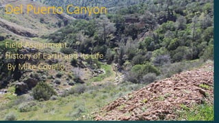
6. Del Puerto Canyon
• Del Puerto Canyon has
several different types of
rock formations.
• The canyon has a host of
different Birding sites
along with an amazing
assortment habitats. (DEL
PUERTO CANYON)
7. Bedded Chert
• This picture shows
bedded chert.
• Cert is sedimentary rock
rich in silica. (Chert)
• Bedded Chert is made
up of microcrystalline or
cryptocrystalline
composed of silicon
dioxide. (Chert, Wiki)
• Chert may contain fossils
or micro-fossils. (Chert,
Wiki)
8. • The folding in the chert is
caused by the oceanic
sediments being scraped off
by the subducting Pacific
Plate and attached onto the
North American margin at
the subduction zone. (Chert)
9. • Bedded chert is only
developed in deep ocean
settings, that contain little
mud particles to dilute the
silica. (Chert)
• The thin layers may be due to
changes in the oceanic silica
productivity caused by
changing orbital cycles. (Chert)
10. Mafic Rock
• This picture is of an
ultramafic rock with an
intrusion of magnesite.
(Hayes, G. 1970)
• The rock pictured here is
Peridotite an ultramafic
rock with a low silica
content less than 45%
and is high in
magnesium and iron.
(Peridotite, Wiki)
11. • In this picture you can
see the high level of
intrusions caused by
magnesium being
released into hot water
solutions that would
later form magnesite.
(Hayes, G. 1970)
• These intrusions are very
small less than 1 inch
thick.
12. • The magnesite found in
these rocks was mined
during the two World
Wars. (Hayes, G. 1970)
• These rocks also give
clues that there is large
amounts of iron in the
rocks below. (Hayes, G. 1970)
•
13. Law of cross-cutting
Relationships
This picture
demonstrates the Law
of Cross-Cutting
Relationships in order
for the intrusion to cut
through the rock the
rock would have to be
in place first, so using
this principle the
intrusion would be
younger than the rock.
(Cross-cutting relationships, Wiki)
14. Steno’s Principle of
Superposition
• In this picture you can
clearly see the different
levels of sediment.
Following Steno’s Principle
of Superposition the
younger sediment would be
on top while the older
sediment would be on the
bottom. (Laboratory 1)
16. Blue Grosbeak
• Also known as Passerina
caerulea
• The blue Grosbeak’s diet
consists of seeds, snails,
and insects. (Blue Grosbeak)
• The Blue Grosbeak has a
very thick bill used for
cracking seeds. (Blue
Grosbeak)
17. • The male pictured here
is deep blue while the
female is brown. (Blue
Grosbeak)
• The Blue Grosbeak is a
migratory bird and is
found in North and
Central America. (Blue
Grosbeak)
• The Blue Grosbeak is
found in a large
geographic area from
southern Mexico in the
south to North Dakota in
the northern United
States. (Blue Grosbeak)
18. • While this bird covers a large
area little is known about its
biology. (Blue Grosbeak)
• The Blue Grosbeak is believed
to be in the family of the
Cardinal and the Blue Bunting.
(Blue Grosbeak)
• The Blue Grosbeak is believed
to be the sister of the Lazuli
Bunting.
• There are believed to be six
subspecies of Grosbeak. (Blue
Grosbeak)
19. • Specimens that are
approximately 4 million
years old found in
Yepomera in west
Chihuahua, Mexico are
believed to be from a
common ancestor “the
Lazuli Bunting”. Placing at
least the ancestor of this
bird in central America
approximately 4 million
years age. (Blue Grosbeak)
• From there this bird has
spread both to the north
and to the south covering
most of central and north
America. (Blue Grosbeak)
20. Tree Tobacco
• Nicotiana glauca also
known as Tree Tobacco is
a species of wild tobacco.
(Nicotiana glauca Graham Tree
tobacco)
• Unlike other plants in the
Nicotianta family this
plant does not contain
nicotine instead it
contains a similar
compound called
anabasine that is highly
toxic to humans and
animals. (Nicotiana glauca
Graham Tree tobacco)
21. Tree Tobacco
• Tree Tobacco has several
common names
including: Mustard tree,
tobacco bush, tobacco
plant, and wild tobacco.
(Scientific name)
• The Tree Tobacco is
native to South America
and is an invasive plant.
(Scientific name)
22. Tree Tobacco
• The Tree Tobacco plant
is a seed bearing plant.
(Scientific name)
• This plant grows in a
wide variety of open and
disturbed areas and is
most seen in relatively
dry areas. (Scientific name)
• It is in the Solanaceae
family. (Scientific name)
23. Tree Tobacco
• It is known that the plant
originated in south America
little else is known about its
early beings.
• The plant is an angiosperm so
the earliest ancestors would
have originated in the early
Cretaceous Period. (Monroe, J. S., &
Wicander, R. 2012)
• As a flowering seed bearing
plant Tree Tobacco has spread
over a large part of the planet.
(Nicotiana glauca)
24. • This map shows all of the
known locations were Tree
Tobacco is currently growing.
(Nicotiana glauca)
Picture by: Isabel Jones, consultant, UK
Tree Tobacco
25. Tree Tobacco
• The spread and introduction of
this plant has been traced back
to the 1800’s with it’s accidental
introduction to the Hawaiian
Islands in 1865 it is now on
most of the Hawaiian Islands.
(Nicotiana glauca)
26. Tree Tobacco
• Tree Tobacco was first
recorded in California in
1879. (Nicotiana glauca)
• It was originally introduced
as landscaping. (Nicotiana
glauca)
• The plant spreads quickly
due in part to the high
number of seeds that it
produces form 10,000 to
1,000,000 seeds per plant
per year. (Nicotiana glauca)
27. Interseting fact
about Del Puerto
Canyon
• On June 11, 1936 Allen
Benison found the bones
of a hadrosaurus. This
was the first dinosaur
discovered in California.
(Barrows, M. )
28. Citations:
• Blue Grosbeak. (n.d.). Retrieved from https://birdsna.org/Species-
Account/bna/species/blugrb1/systematics#subsp
• Nicotiana glauca Graham Tree tobacco - UC WeedRIC. (n.d.). Retrieved from
http://www.bing.com/cr?IG=BF8BB87D59F042CFAE22F87D967EBAC5&CID=135FCFDBADC3692431B1
C3CBAC3E6860&rd=1&h=sdZVGUhWGap0aoJKLHLJKrMRyMvea0TTJrdy1pQSUHM&v=1&r=http://wri
c.ucdavis.edu/information/natural areas/wr_N/Nicotiana.pdf&p=DevEx.LB.1,5057.1
• Scientific name. (n.d.). Retrieved from
http://keys.lucidcentral.org/keys/v3/eafrinet/weeds/key/weeds/Media/Html/Nicotiana_glauca_(Tree_To
bacco).htm
• Nicotiana glauca (tree tobacco). (n.d.). Retrieved from https://www.cabi.org/isc/datasheet/36324
• Monroe, J. S., & Wicander, R. (2012). The changing earth: Exploring geology and evolution. Belmont,
CA: Brooks/Cole.
• Cross-cutting relationships. (2018, June 15). Retrieved from https://en.wikipedia.org/wiki/Cross-
cutting_relationships
29. Citations:
• https://en.wikipedia.org/wiki/Chert
• Chert. (n.d.). Retrieved from https://www.nps.gov/prsf/learn/nature/chert.htm
• Investors, S. @. (n.d.). Geology Fundamentals – Veins, Dikes and Sills . Retrieved from
https://www.geologyforinvestors.com/geology-fundamentals-veins-dikes-and-sills/
• Barrows, M. (n.d.). PALEONEWS: Del Puerto Canyon.
• Diablo Range. (2018, June 15). Retrieved from https://en.wikipedia.org/wiki/Diablo_Range
• DEL PUERTO CANYON. (n.d.). Retrieved from http://www.stanislausbirds.org/home/birding-sites---
stanislaus/del-puerto-canyon
• Peridotite. (2018, June 15). Retrieved from https://en.wikipedia.org/wiki/Peridotite
• Hayes, G. (1970, January 01). Spending a Day in the Earth's Mantle: Exploring Del Puerto Canyon in
California's Coast Ranges. Retrieved from http://geotripper.blogspot.com/2011/12/spending-day-in-
earths-mantle-exploring.html
• All photo’s taken by the author of this report unless other wise indicated.