This document provides a curriculum vitae for Lasisi Kazeem Eyitayo, a Nigerian national with a PhD in Statistics from Abubakar Tafawa Balewa University. It lists his personal details, education history, work experience conducting surveys and providing statistical analysis support for various organizations, teaching experience as a university lecturer, and publications. His work experience includes roles supporting nutrition, health, and education programs through data collection, analysis, and reporting.
Conceptual and Operational Methodology for Mapping Orphan Population in Anam...ANUMBA JOSEPH UCHE
The essence of mapping the orphan population fosters holistic child development that clusters on the pillars of rights of the child which includes survival, protection and participation of the child. Thus, some of the core aims/objective of the conceptual and operational methodology for mapping Orphan population in Anambra State are contained in this document
An Empirical Study of the Geospatial Availability of Hospitals in Imo East us...ijtsrd
The accessibility of hospital facilities contributes to social stability and the protection of the fundamental human right to health care. This study aimed to examine the geographical distribution of hospital care facilities and their attribute information in the nine Local Government Areas LGA of the Imo East District by developing a database and producing a visual map of these facilities. The facilities investigated were divided into different groups by type, ownership, and operational state. The attribute data that makes up the database was obtained through questionnaires distributed to facility management. Geospatial data was collected using a handheld Global Positioning System GPS . The maps received from the government agencies integrated with the ArcGIS environment were used for the visual mapping of the facilities. Statistical Package for the Social Sciences SPSS was used to analyze the data. The results suggest that there are 837 health facilities, with Ahiazu and Ezinihitte having the fewest 8.1 and 8.5 , respectively , and Ngor Okpala having the most sparsely distributed. The areas with the most facilities are Aboh and Ikeduru, with 13.3 and 13.0 , respectively. The ownership of private and public facilities was 59.3 and 40.7 , respectively. The facilities are not evenly dispersed, and their standards vary substantially. The database created would surely aid in management, planning, and encouraging new avenues in health administration. The visual map produced illustrates the locations of health institutions, and road connectivity by type, and is an essential source of health information. The visual map available to the public can increase the number of patients who travel to the proper hospitals and prevent patients from seeking health treatment in the wrong place. As a result, the findings of this study may aid in the administration of health facilities and future planning. Umunnakwe George E. | Obasi Ibe B. "An Empirical Study of the Geospatial Availability of Hospitals in Imo East using GPS Mapping" Published in International Journal of Trend in Scientific Research and Development (ijtsrd), ISSN: 2456-6470, Volume-7 | Issue-3 , June 2023, URL: https://www.ijtsrd.com.com/papers/ijtsrd56325.pdf Paper URL: https://www.ijtsrd.com.com/other-scientific-research-area/other/56325/an-empirical-study-of-the-geospatial-availability-of-hospitals-in-imo-east-using-gps-mapping/umunnakwe-george-e
2013 HIV/AIDS/STDs & Human Sexuality Annual ConferenceTravis Barnhart
Includes portions of the conference program highlighting presentations by Travis Barnhart.
Best of the Past
Best of the Future
Sponsored by
Iowa Department of Education
Kansas Department of Health & Environment
Kansas State Department of Education
Missouri Department of Health & Senior Services
Practice and Challenges of Villagization, In the Case of Selected Woreda of A...Premier Publishers
Villagization has been defined "the grouping of the population into centralized planned settlements" (Steingraber, 1987). The overall objective of this study is to explore the practice and challenges of villagization; in the selected woredas of the Assosa zone Beninshangul Gumuz regional state. To achieve goals of the survey study mixed research method was employed. Generally, the Sample size of 168 sample households was determined by using Krejcie & Morgan (1970) formula. The research employed descriptive research design on the challenges and implementation of the program, and it applied mainly qualitative methods. As this study showed, the villagization has improved communication and interaction among the villagers due to their togetherness. When villagization was implemented the lives of the villagers improved because they started to have better access to social services. The study showed that villagization was implemented voluntarily and based on the consent of the local people. However, it is possible to conclude that villagization has significantly improved the lives of the villagers by bringing positive changes that did not exist before people.
Developing Partnerships to Promote Innovative Approaches YTH
Partnerships that Promote the Integration of HIV, STD and Teen Pregnancy Prevention was presented at Sex::Tech 2009 by Sandra Serna Smith of the National Coalition of STD Directors and Lisa Pressfield of the Association of Maternal and Child Health Programs.
Geospatial Mapping and Analysis of the Distribution of Public Primary Healthc...ijtsrd
This study investigated the geospatial analysis and mapping of the distribution of public primary healthcare centers PPHCs in Kaduna State, Nigeria. The study adopted a cross sectional survey design and employed purposive and systematic random sampling techniques to select three LGAs in each of the three Senatorial zones of Kaduna State. At the State Subnational , Senatorial, and Local Government Areas LGAs levels, a three step hierarchical geospatial analysis was carried out using nearest neighbor analysis. The coordinates of the PPHCs that the Global Positioning Systems had gathered in the study area were used in the study. In order to determine the distribution pattern of the PPHCs, additional analysis was performed using the coordinates imported into the ArcGIS interface. While the nearest neighbor analysis was used to examine the distribution, patterns present in the location of the PPHCs, descriptive statistics were used to describe the nature of the distribution. Findings showed that at significant spatial scales, the point pattern of PPHCs was random in Kaduna State z=1.046 p=0.296 Kaduna North Senatorial Zone z=0.215 p=0.82 Kaduna Central Senatorial Zone z=1.387 p=0.165 and Kaduna South Senatorial Zone z= 1.093 p=0.274 , while at the LGA level variations were observed with a few clustered and dispersed and yet majority showed random distribution. The World Health Organizations recommendation of 5km for distances between and among PPHCs was exceeded at all levels, according to the Nearest Neighbor Analysis. For instance, the observed mean distance for the senatorial pattern is 5.28 km, 7.29 km, and 7.14 km, respectively, for the senatorial zones of Kaduna North, Kaduna Central, and Kaduna South. According to the studys findings, the distribution pattern was skewed and suggested a non proportional type. Therefore, it is recommended that additional electoral wards should be created or PPHCs should be built in the underserved LGAs while taking the centers accessibility and population density into consideration. Peter Danjuma Averik | Andrew Adesola Obafemi | Gladys Chineze Emenike "Geospatial Mapping and Analysis of the Distribution of Public Primary Healthcare Centers in Kaduna State, Nigeria." Published in International Journal of Trend in Scientific Research and Development (ijtsrd), ISSN: 2456-6470, Volume-7 | Issue-5 , October 2023, URL: https://www.ijtsrd.com/papers/ijtsrd60069.pdf Paper Url: https://www.ijtsrd.com/other-scientific-research-area/enviormental-science/60069/geospatial-mapping-and-analysis-of-the-distribution-of-public-primary-healthcare-centers-in-kaduna-state-nigeria/peter-danjuma-averik
Environmental psychology is an interdisciplinary field that focuses on the interplay between individuals and their surroundings. The field defines the term environment broadly, encompassing natural environments, social settings, built environments, learning environments, and informational environments.
In the context of India, the first part of the presentation attempts at orienting veterinarian to a service delivery approach needed to augment livestock enterprise development. The second part addresses key veterinary professional development issues in India and suggests ways to address them.
Geospatial Mapping of Health Facilities in Nangere Local Government Area of Y...ijtsrd
This paper is aimed at mapping healthcare facilities in the Nangere Local Government Area of Yobe State. Geospatial mapping of health care facilities was achieved by taking the geographic coordinates of all the healthcare facilities in the Local Government using the Global Positioning System Garmin GPS map 76CS receiver. The data were analyzed using ArcGIS 10.8 version software. The study identified primary and secondary health care facilities without any tertiary health care facility and also without a single private hospital or clinic across the entire eleven 11 political wards of Nangere Local Government Area. The findings revealed that 46 healthcare facilities were distributed across the eleven 11 political wards in the Local Government Area. The primary health care facilities PHC constituted 98 45 while the secondary Health Care facilities SHC constituted 2 1 . The average nearest neighbor summary for the study area shows the significant level and the critical level that indicates a random distribution pattern of health care facilities in the area, however, it was unevenly distributed given the concentration of health care facilities in Dazigau, Degubi, Darin, Pakarau, and Tikau while other wards were inadequately served. However, both the primary and secondary health care facilities were government owned, the study concluded that there were inequalities in the spatial distribution of health care facilities in the Nangere Local Government Area of Yobe state, thus this disparity in the distribution of health facilities has generated different accessibility level to health care facilities in the LGA, it, therefore, recommends that Government and the private organization should provide health care facilities in the wards that do not have enough health care facilities. This will further improve access to Health Care facilities in the study area. Ibrahim Abubakar Audu | Tijjani Bukar Lawan "Geospatial Mapping of Health Facilities in Nangere Local Government Area of Yobe State, Nigeria" Published in International Journal of Trend in Scientific Research and Development (ijtsrd), ISSN: 2456-6470, Volume-5 | Issue-4 , June 2021, URL: https://www.ijtsrd.compapers/ijtsrd42527.pdf Paper URL: https://www.ijtsrd.comother-scientific-research-area/other/42527/geospatial-mapping-of-health-facilities-in-nangere-local-government-area-of-yobe-state-nigeria/ibrahim-abubakar-audu
Spatiotemporal Analysis of Infant and Maternal Morality of Mother and Child T...IJMTST Journal
Community healthcare is significant societal issue with profound suggestions for government organization
and with huge effect on individual standards of livelihood. The maintaining and monitoring of numerous
health associated government schemes are done through information technology where involvement of
Geographic Information System (GIS) is missing. This Project intends in integrating a GIS with Infant and
Maternal Mortality of Mother and Child Tracking System (MCTS). Thematic Mapping is a component of GIS
where it has constantly characterized to demonstrate the current status of health issues in an influential
way. The open source tool Quantum GIS (QGIS) is used to represent Infant and Maternal Mortality on
Thematic Maps which helps in identifying the areas with higher and weaker distributions of affected
population.
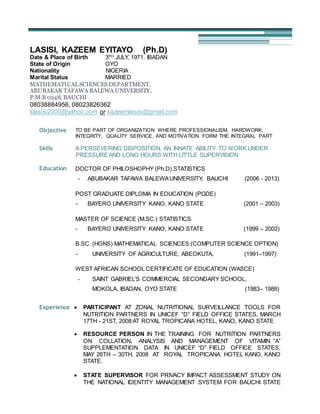
1. LASISI, KAZEEM EYITAYO (Ph.D)
Date & Place of Birth 3RD
JULY, 1971. IBADAN
State of Origin OYO
Nationality NIGERIA
Marital Status MARRIED
MATHEMATICALSCIENCES DEPARTMENT,
ABUBAKAR TAFAWA BALEWA UNIVERSITY,
P.M.B 0248, BAUCHI
08038884956, 08023826362
klasisi2000@yahoo.com or kazeemlasisi@gmail.com
Objective TO BE PART OF ORGANIZATION WHERE PROFESSIONALISM, HARDWORK,
INTEGRITY, QUALITY SERVICE, AND MOTIVATION FORM THE INTEGRAL PART
Skills A PERSEVERING DISPOSITION, AN INNATE ABILITY TO WORK UNDER
PRESSUREAND LONG HOURS WITH LITTLE SUPERVISION
Education DOCTOR OF PHILOSHOPHY (Ph.D) STATISTICS
- ABUBAKAR TAFAWA BALEWAUNIVERSITY, BAUCHI (2006 - 2013)
POST GRADUATE DIPLOMA IN EDUCATION (PGDE)
- BAYERO UNIVERSITY KANO, KANO STATE (2001 – 2003)
MASTER OF SCIENCE (M.SC.) STATISTICS
- BAYERO UNIVERSITY KANO, KANO STATE (1999 – 2002)
B.SC. (HONS) MATHEMATICAL SCIENCES (COMPUTER SCIENCE OPTION)
- UNIVERSITY OF AGRICULTURE, ABEOKUTA, (1991–1997)
WEST AFRICAN SCHOOL CERTIFICATE OF EDUCATION (WASCE)
- SAINT GABRIEL’S COMMERCIAL SECONDARY SCHOOL,
MOKOLA, IBADAN, OYO STATE (1983– 1988)
Experience PARTICIPANT AT ZONAL NUTRITIONAL SURVEILLANCE TOOLS FOR
NUTRITION PARTNERS IN UNICEF “D” FIELD OFFICE STATES, MARCH
17TH - 21ST, 2008 AT ROYAL TROPICANA HOTEL, KANO, KANO STATE
RESOURCE PERSON IN THE TRAINING FOR NUTRITION PARTNERS
ON COLLATION, ANALYSIS AND MANAGEMENT OF VITAMIN “A”
SUPPLEMENTATION DATA IN UNICEF “D” FIELD OFFICE STATES,
MAY 26TH – 30TH, 2008 AT ROYAL TROPICANA HOTEL KANO, KANO
STATE.
STATE SUPERVISOR FOR PRIVACY IMPACT ASSESSMENT STUDY ON
THE NATIONAL IDENTITY MANAGEMENT SYSTEM FOR BAUCHI STATE
2. BY NATIONAL IDENTITY MANAGEMENT COMMISSION, ABUJA.
DECEMBER 3RD – 10TH, 2008.
RESOURCE PERSON IN THE TRAINING OF SUPERVISORS ON
MAPPING OF PMTCT/PAEDIATRIC HIV/AIDS SERVICE DELIVERY
POINTS IN ADAMAWA, GOMBE AND TARABA STATES BY UNICEF “D”
FIELD OFFICE. AUGUST 11TH – 15TH, 2009. AT EMERALD ROYAL
HOTEL, GOMBE
RESOURCE PERSON AT THE PLANNING MEETING AND DEVELOPMENT
OF QUESTIONNAIRE FOR CONDUCT OF KAP STUDY ON EXCLUSIVE
BREASTFEEDING PRACTICES IN ADAMAWA, BORNO, GOMBE & YOBE
STATES FOR UNICEF D-FIELD OFFICE, SEPTEMBER 8TH – 11TH, 2009
AT CREST HOTELS & GARDEN JOS, PLATEU STATE.
RESOURCE PERSON FOR DATA STRUCTURE DESIGN, DATA ENTRY,
CLEANING, ANALYSIS AND RESULT PRESENTATION (USING SPSS 16)
OF THE MAPPING TOOL FOR PMTCT/PAEDIATRIC HIV/AIDS FOR
UNICEF “D” FIELD OFFICE. SEPTEMBER – DECEMBER, 2009.
RESOURCE PERSON AT A 2-DAY FEEDBACK MEETING ON FIELD
TESTED KNOWLEDGE, ATTITUDE & PRACTICE (KAP) STUDY TOOLS
AND TRAINING OF EXTERNAL RESOURCE PERSONS AND STATE
PARTNERS ON THE CONDUCT OF KAP STUDY ON EXCLUSIVE
BREASTFEEDING PRACTICES IN ADAMAWA, BORNO, GOMBE & YOBE
STATES. NOVEMBER 2ND – 3RD, 2009 AT DUNOMA HOTEL, LAFIA,
NASSARAWA STATE.
ZONAL MONITOR IN A FIELD SURVEY CONDUCTED TO FIND THE
KNOWLEDGE, ATTITUDE AND CURRENT PRACTICES (KAP), AS
REGARDS EXCLUSIVE BREASTFEEDING FEEDING PRACTICES; AND
TO ELICIT POSSIBLE SUGGESTIONS FROM THE COMMUNITY PEOPLE
ON IMPROVING CURRENT PRACTICES IN 4 UNICEF D FIELD OFFICE
STATES OF ADAMAWA, BORNO, GOMBE & YOBE. NOVEMBER 8TH –
13TH, 2009, AT BORNO STATE.
RESOURCE PERSON FOR DATA STRUCTURE DESIGN, DATA ENTRY,
CLEANING, ANALYSIS AND RESULT PRESENTATION (USING SPSS 16)
FOR THE KAP STUDY TOOLS ON EXCLUSIVE BREASTFEEDING
PRACTICES IN ADAMAWA, BORNO, GOMBE & YOBE STATES. JANUARY
– MARCH, 2010.
RESOURCE PERSON AT AN IN-DEPT REVIEW OF ANALYSIS/REPORT
WRITING OF KAP STUDY ON EXCLUSIVE BREASTFEEDING PRACTICES
IN 4 STATES OF ADAMAWA, BORNO, GOMBE AND YOBE STATES.
MARCH 21ST – 31ST, 2010. AT TAHIR GUEST PALACE, KANO.
ZONAL INDEPENDENT MONITOR AT THE MATERNAL NEWBORN AND
CHILD HEALTH WEEK (MNCHW) FOR UNICEF D-FIELD OFFICE, JULY
29TH – AUGUST 10TH, 2010 IN ADAMAWA STATE.
3. RESOURCE PERSON AT THE FINALIZATION OF KAP STUDY REPORT
ON EXCLUSIVE BREASTFEEDING (EBF) PRACTICES IN ADAMAWA,
BORNO, GOMBE AND YOBE STATES. AUGUST 22ND – 28TH, 2010 AT
TAHIR GUEST PALACE, KANO.
ZONAL INDEPENDENT MONITOR AT THE MATERNAL NEWBORN AND
CHILD HEALTH WEEK (MNCHW) FOR UNICEF D-FIELD OFFICE,
NOVEMBER, 25TH – DECEMBER, 4TH, 2010 IN YOBE STATE.
RESOURCE PERSON FOR DATA STRUCTURE DESIGN, DATA ENTRY,
CLEANING AND ANALYSIS (USING SPSS 16) OF THE SURVEY
INSTRUMENTS FOR ASSESSMENT OF THE DEMAND FOR AND SUPPLY
OF VOCATIONAL SKILL TRAINING PROGRAMS FOR OLDER ORPHAN
AND VULNERABLE CHILDREN (OVC) IN BAUCHI STATE BY NIGERIA
NORTHERN EDUCATION INITIATIVE (NEI). MARCH 2011
ZONAL INDEPENDENT MONITOR AT THE MATERNAL NEWBORN AND
CHILD HEALTH WEEK (MNCHW) FOR UNICEF D-FIELD OFFICE, JUNE,
3RD – 11TH, 2011 IN ADAMAWA STATE.
RESOURCE PERSON AT THE CAPACITY BUILDING OF STATE & LGA
OFFICERS ON COMMUNITY BASED MANAGEMENT OF ACUTE
MALNUTRITION (CMAM) DATA MANAGEMENT, DEVELOPMENT OF
SCALE UP PLAN AND SUPPORTIVE SUPERVISION/MONITORING BY
BAUCHI STATE AGRICULTURAL DEVELOPMENT PROGRAMME (BSADP)
IN COLLABORATION WITH UNICEF D FIELD OFFICE. JULY, 19TH -23RD,
2011 AT ROYAL TROPICANA HOTEL, KANO
ZONAL INDEPENDENT MONITOR AT THE MATERNAL NEWBORN AND
CHILD HEALTH WEEK (MNCHW) FOR UNICEF D-FIELD OFFICE,
NOVEMBER, 16TH – 30TH, 2011 IN ADAMAWA STATE.
LEAD CONSULTANT (QUANTITATIVE RESEARCH), ON ASSESSMENT
OF PROVISION AND ADOPTION OF LONG ACTING FAMILY PLANNING
METHOD IN HEALTH FACILITIES AMONG THE POTENTIAL USERS FOR
JSI RESEARCH AND TRAINING INSTITUTE, INC. TARGET STATE HIGH
IMPACT PROJECT (TSHIP), BAUCHI. OCTOBER 26TH - DECEMBER 2ND,
2011.
MONITORING AND EVALUATION (M&E) CONSULTANT FOR HEALTH, TO
PROVIDE TECHNICAL ASSISTANCE THAT SUPPORT THE ADAPTATION
OF THE BOTTLENECK ANALYSIS TOOL INTO THE PRIMARY HEALTH
CARE (PHC) REVIEWS IN THE NORTH EASTERN STATES OF NIGERIA
FOR UNICEF, ABUJA. MAY 3OTH – AUGUST 31ST,2012
MONITORING AND EVALUATION (M&E) CONSULTANT FOR HEALTH, TO
PROVIDE TECHNICAL ASSISTANCE THAT SUPPORT THE ADAPTATION
OF THE BOTTLENECK ANALYSIS TOOL INTO THE PRIMARY HEALTH
CARE (PHC) REVIEWS IN THE NORTH EASTERN STATES OF NIGERIA
FOR UNICEF, ABUJA. NOVEMBER 5TH, 2012 – APRIL 30TH, 2013
4. TECHNICAL RESOURCE PERSON TO SUPPORT PLANNING AND
COORDINATION OF MNCH WEEK FOR MAY 2013 IN ADAMAWA STATE.
MAY, 7TH – 17TH, 2013.
ZONAL INDEPENDENT MONITOR AT THE MATERNAL NEWBORN AND
CHILD HEALTH WEEK (MNCHW) FOR UNICEF D-FIELD OFFICE, 27TH
NOV. – 9TH DEC., 2013 IN KANO STATE.
ZONAL INDEPENDENT MONITOR AT THE MATERNAL NEWBORN AND
CHILD HEALTH WEEK (MNCHW) FOR UNICEF D-FIELD OFFICE, 30TH
MAY – 9TH JUNE, 2014 IN BORNO STATE.
LEAD RESOURSE PERSON FOR BASELINE SURVEY IN THE SELECTED
THREE (3) LGAs (BIRNI MAGAJIN, TALATA MAFARA AND TSAFE) OF
ZAMFARA STATE FOR SHAWN II PROGRAMME OF DFID COORDINATED
BY UNICEF C-FIELD OFFICE, AUGUST 2014 – JANUARY, 2015.
RESEARCH CONSULTANT FOR ARESEARCH STUDY ON IMPACT OF E-
LIBRARY ON THE ACADEMIC PERFORMANCE OF STUDENTS OF
SCHOOL OF NURSING, ATBU BAUCHI. FOR JSI RESEARCH AND
TRAINING INSTITUTE, INC. TARGET STATE HIGH IMPACT PROJECT
(TSHIP), BAUCHI. MAY 18TH
– JUNE 15TH
, 2015
RESOURCE PERSON FOR THE DEVELOPMENT OF LOCAL
GOVERNMENT INVESTMENT PLANS (LIP) FOR SHAWN SUPPORTED
STATES – II FOR UNICEF ABUJA, AT BOLTON WHITE HOTEL, ABUJA.
23RD
– 27TH
JUNE, 2015
RESOURCE PERSON TO FACILITATE LGA AND COMMUNITY LEVEL
ACTIVITIES FOR IMPROVEMENT OF QUALITY OF CARE FOR
COMMUNITY BASED MANAGEMENT OF SEVERE ACUTE
MALNUTRITION IN KANO STATE. 4TH
– 14TH
JULY, 2015.
TEACHING EXPERIENCE:
- SENIOR LECTURER, MATHEMATICAL SCIENCE DEPT., ABUBAKAR
TAFAWA BALEWA UNIVERSITY, P.M.B. 0248, BAUCHI (2012 TO DATE)
- LECTURER I, MATHEMATICAL SCIENCE PROGRAMME, ABUBAKAR
TAFAWA BALEWA UNIVERSITY, P.M.B. 0248, BAUCHI (2009 - 2012)
- LECTURER II, MATHEMATICAL SCIENCE PROGRAMME, ABUBAKAR
TAFAWA BALEWA UNIVERSITY, P.M.B 0248, BAUCHI (2006 - 2009)
- ASSISTANT LECTURER, MATHEMATICAL SCIENCE PROGRAMME,
ABUBAKAR TAFAWA BALEWA UNIVERSITY, BAUCHI (2003 - 2006)
- ASSISTANT LECTURER, DEPARTMENT OF MATHS/COMPUTER, FEDERAL
COLLEGE OF EDUCATION (TECH.), BICHI, KANO STATE (2002 – 2003)
5. - BRANCH CO-ORDINATOR/INSTRUCTOR, SHAM-LAD PROFESSIONAL
COMPUTER INSTITUTE, 73 CLUB ROAD, KANO (1999 – 2002)
- SYSTEM ANALYST, ROFACONSTRUCTION LIMITED, 72 AIRPORT ROAD,
KANO (1998 – 1999).
- COURSE TUTOR, DEPARTMENT OF MATHEMATICS NCE (DLS) NTI, JADA
STUDY CENTER,ADAMAWA STATE (1997 -1998)
- NYSC, GOVERNMENT SECONDARYSCHOOL, JADA, ADAMAWA STATE.
(1997 – 1998)
Publications 1) LASISI, K. E. AND OYAWOYE O. M. (2009): “ANALYSIS ON IMPURITY
NATURE (COLIFORM BACTERIA) OF DRINKING WATER IN BAUCHI
METROPOLIS (USING 23
FACTORIAL DESIGNS)”. INTERNATIONAL JOURNAL
OF PURE AND APPLIED SCIENCE. 2(1), 75-84.
2) LASISI, KAZEEM EYITAYO (2009): “MONITORING SEASONAL BEHAVIOURS
IN THE PREVALENCE OF COCCIDIOSIS DISEASE. JOURNAL OF SCIENCE AND
TECHNOLOGY RESEARCH, 8(3), 77-85.
3) LASISI, K. E., YAHAYA, O. M. AND SULEIMAN, O. B. (2009): “MODELLING
THE RATE OF ROAD TRAFFIC ACCIDENTS IN NIGERIA USING ARIMA
METHOD”. JOURNAL OF MATHEMATICAL SCIENCE AND EDUCATION (JMSE),
1(1), 153-176.
4) LASISI, KAZEEM EYITAYO (2010): “ANALYSIS AND FORECASTING FOR
HUMAN POPULATION PROJECTION IN NIGERIA USING TIME SERIES
TECHNIQUES”. PECOP JOURNAL OF SCIENCE, ENGINEERING &
TECHNOLOGY, 8(1&2), 1-9.
5) ABDULAZEEZ, K. A., ATURETA, M. S. AND LASISI, K. E. (2010):
“OPTIMIZATION OF TIME IN THE PRODUCTION OF FISH FEED” BIOLOGICAL
AND ENVIRONMENTAL SCIENCES JOURNAL FOR THE TROPICS, 7(3), 50-55.
6) LASISI, K. E, ALI, O. AND ABDULAZEEZ, K. A (2011): “QUALITY CONTROL
USING TAGUCHI APPROACH FOR BAUCHI MEAT PRODUCTS COMPANY,
BAUCHI STATE”. INTERNATIONAL JOURNAL OF DEVELOPMENT STUDIES, 6(2),
110-119.
7) LASISI, K. E, ATURETA, M. S, ABDULAZEEZ, K. A. AND GASHIM, C. (2012):
“ANALYSIS OF IRON ORE TAILING (IOT) CONCRETE USING 25
FACTORIAL
DESIGN” INTERNATIONAL JOURNAL OF RESEARCH AND ADVANCEMENT IN
PHYSICAL SCIENCE, 2(1), 107-111.
6. 8) LASISI, K. E, ADEBAYO, S. B., S. C. NWAOSU AND M. S. SESAY (2012):
“ASSESSMENT OF NUTRITIONAL STATUS OF NIGERIAN CHILDREN”. SCIENCE
FORUM, JOURNAL OF PURE AND APPLIED SCIENCES, 13(1), 18-27.
9) ABDULKADIRI, A., LASISI, K. E, AND MAIBULANGU, S. M. (2012): “EFFECT
OF FERTILIZER ON YIELD OF MAIZE AND SORGHUM, USING DESIGN OF
EXPERIMENT (DOE) TECHNIQUES”. INTERNATIONAL JOURNAL OF
AGRICULTURE, 4(3), 4-13.
10) LASISI, K. E, ABDULAZEEZ, K. A. AND EMMANUEL S. ADIGUN (2014):
“SUITABILITY OF IRON ORE TAILING (IOT) IN BUILDING CONSTRUCTION”
SCSR JOURNAL OF PURE AND APPLIED SCIENCES (SCSR-JPAS), 1(1) 05 – 11.
11) LASISI, K. E, NWAOSU, S.C. AND ABDULAZEEZ, K. A (2014): “GEOADDITIVE
COX MODELS WITH GAUSSIAN AND BINOMIAL LINKS FOR THE ANALYSIS OF
WASTING STATUS OF NIGERIAN CHILDREN” IISTE JOURNAL OF NATURAL
SCIENCES RESEARCH, 4(15), 64-70.
12) LASISI, K. E, ADEBAYO, S.B AND ABDULHAMID, B.M (2014): “ANALYSIS OF
NIGERIAN CHILDREN UNDERWEIGHT NUTRITIONAL STATUS USING
GEOADDITIVE COX MODELS WITH GAUSSIAN AND BINOMIAL LINKS” AFRICA
DEVELOPMENTAND RESOURCES RESEARCH INSTITUTE (ADRRI) JOURNAL
10(2), 1-12.
Referees PROF. M. I. BELLO,
MATHEMATICAL SCIENCE DEPARTMENT,
FACULTY OF SCIENCE,
ABUBAKAR TAFAWA BALEWA UNIVERSITY,
P.M.B. 0248, BAUCHI,
TEL: 08087685701
PROF. M. S. ATURETA
MATHEMATICAL SCIENCE DEPARTMENT,
FACULTY OF SCIENCE,
ABUBAKAR TAFAWA BALEWA UNIVERSITY,
P.M.B. 0248, BAUCHI,
TEL: 08038343480
MR. BAYO A. BHADMUS
DIRECTOR,
MANAGEMENT INFORMATION SYSTEM (MIS)
COLLEGE OF AGRICULTURE, JALINGO
TARABA STATE.
TEL: 08034626311