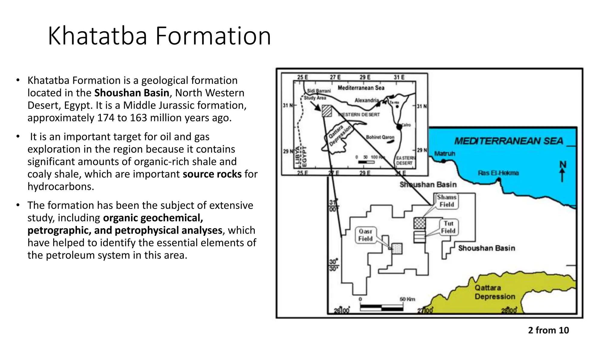
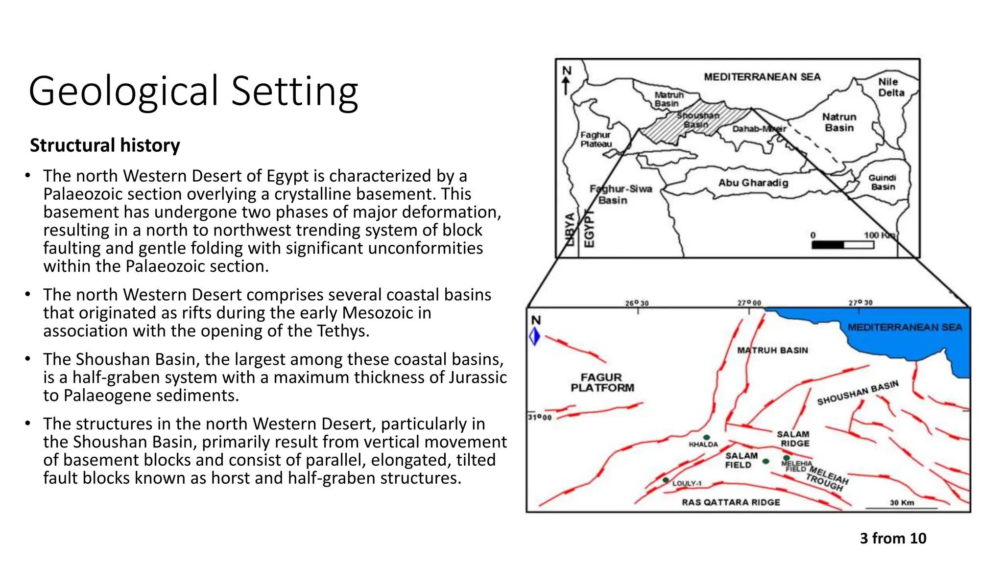
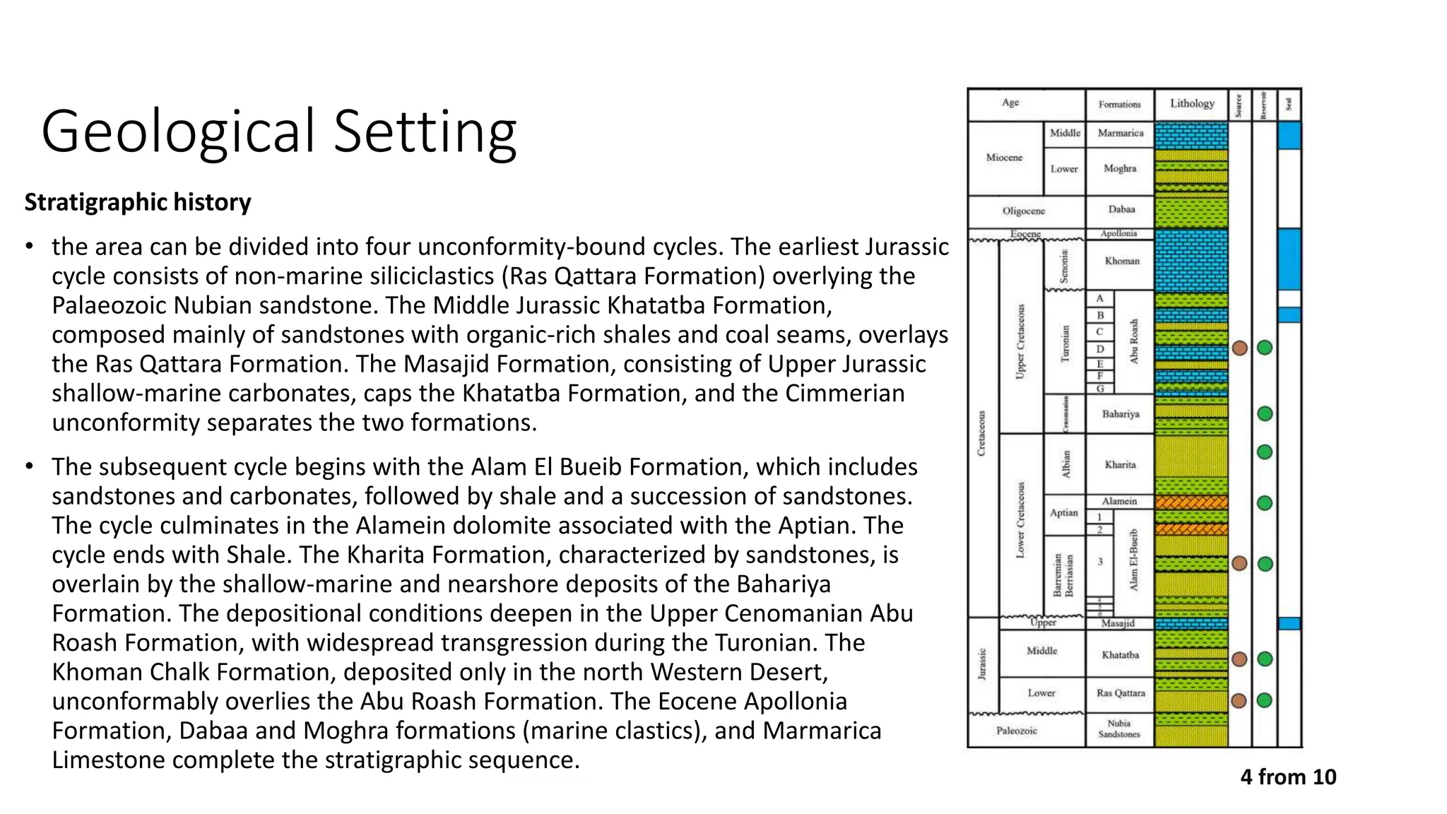
Khatatba Petroleum System
By: Mahmoud H. Abdelrazek
25 November 2023
Petroleum System Analysis
• Petroleum System: Geologically defined
elements and processes that generate,
migrate, and trap hydrocarbons. Includes
source rocks, reservoir rocks, migration
pathways, and traps
• Common techniques in petroleum system
analysis: seismic surveys, well log analysis,
geochemical analysis, and basin modeling.
1 from 10
Khatatba Formation
• Khatatba Formation is a geological formation
located in the Shoushan Basin, North Western
Desert, Egypt. It is a Middle Jurassic formation,
approximately 174 to 163 million years ago.
• It is an important target for oil and gas
exploration in the region because it contains
significant amounts of organic-rich shale and
coaly shale, which are important source rocks for
hydrocarbons.
• The formation has been the subject of extensive
study, including organic geochemical,
petrographic, and petrophysical analyses, which
have helped to identify the essential elements of
the petroleum system in this area.
2 from 10
Structural history
• The north Western Desert of Egypt is characterized by a
Palaeozoic section overlying a crystalline basement. This
basement has undergone two phases of major deformation,
resulting in a north to northwest trending system of block
faulting and gentle folding with significant unconformities
within the Palaeozoic section.
• The north Western Desert comprises several coastal basins
that originated as rifts during the early Mesozoic in
association with the opening of the Tethys.
• The Shoushan Basin, the largest among these coastal basins,
is a half-graben system with a maximum thickness of Jurassic
to Palaeogene sediments.
• The structures in the north Western Desert, particularly in
the Shoushan Basin, primarily result from vertical movement
of basement blocks and consist of parallel, elongated, tilted
fault blocks known as horst and half-graben structures.
3 from 10
Geological Setting
Geological Setting
Stratigraphic history
• the area can be divided into four unconformity-bound cycles. The earliest Jurassic
cycle consists of non-marine siliciclastics (Ras Qattara Formation) overlying the
Palaeozoic Nubian sandstone. The Middle Jurassic Khatatba Formation,
composed mainly of sandstones with organic-rich shales and coal seams, overlays
the Ras Qattara Formation. The Masajid Formation, consisting of Upper Jurassic
shallow-marine carbonates, caps the Khatatba Formation, and the Cimmerian
unconformity separates the two formations.
• The subsequent cycle begins with the Alam El Bueib Formation, which includes
sandstones and carbonates, followed by shale and a succession of sandstones.
The cycle culminates in the Alamein dolomite associated with the Aptian. The
cycle ends with Shale. The Kharita Formation, characterized by sandstones, is
overlain by the shallow-marine and nearshore deposits of the Bahariya
Formation. The depositional conditions deepen in the Upper Cenomanian Abu
Roash Formation, with widespread transgression during the Turonian. The
Khoman Chalk Formation, deposited only in the north Western Desert,
unconformably overlies the Abu Roash Formation. The Eocene Apollonia
Formation, Dabaa and Moghra formations (marine clastics), and Marmarica
Limestone complete the stratigraphic sequence.
4 from 10
Source rock characteristics - Khatatba petroleum system
• Organic petrographic and geochemical characteristics are Based on the
statistical summary of 52 samples from the fields in the Shoushan Basin
• Pyrite and quartz are the main inorganic components observed in these
samples
• Samples have high TOC content (1.0–32.5 wt.%)
• Using petrographic analysis, consist predominantly of type III vitrinitic
and a mixture of types II–III liptinitic and possess moderately to heavily
stained with bitumen
• Khatatba samples that contain type III kerogen would be
expected to generate gas while the samples with hydrogen
index >200 mg HC/g TOC would generate gas and limited
components of liquid hydrocarbon
5 from 10
Hydrocarbon generation - Khatatba petroleum system
6 from 10
• Shams Field selected as a representative site to
model the timing of hydrocarbon generation.
• The models indicate that the onset of the oil
window (corresponding to 0.50–0.60 %Ro) of the
Khatatba source rocks occurred during the Late
Cretaceous (95–75 Ma; Fig. 11).
• The Khatatba source rock reached the main oil
window at the end of the Late Cretaceous, and
the gas window occurred in the Tertiary.
• In summary, hydrocarbon generation started in
the Late Cretaceous (90 Ma), and peak
hydrocarbon generation occurred during the
Tertiary (30–15 Ma).
• Conclusion, the Middle Jurassic Khatatba
Formation is a good source rock in the Shoushan
Basin and has the greatest ability to generate and
economically adequate amounts of hydrocarbon
(mainly gas and oil)
Reservoir rocks - Khatatba petroleum system
7 from 10
• The hydrocarbons discovered in the Shoushan Basin occur hosted in
clastic and carbonate reservoir rocks within the formations and
members ranging from Lower Jurassic to Upper Cretaceous age
• Thin section petrography shows that the Khatatba sandstones are
mostly quartz arenite. These sandstones characterized by fine- to
coarse-grained, moderately to well sorted and mostly subangular to
subrounded with rare rounded grains
• Based on the petrophysical analysis, the Khatatba sandstones have
normal porosity distribution with an average values ranging from 1 to 17
%, and measured permeability values range from 0.05 to 1,000 mD
• Secondary porosity is also recognized in the Khatatba sandstones and
resulted from fracturing and dissolution of calcite cement and unstable
grains
• Thin section photomicrographs of Khatatba sandstones depicting: a
good reservoir quality characterized by coarse grains with good sorting,
no matrix or cements; dissolution of calcite cement; open fractures
giving high possibility for good quality reservoir and ; fracture saturated
with bitumen (black colour) indicating hydrocarbon generation and
migration
Seals and overburden rocks - Khatatba petroleum system
• The carbonate Masajid Formation is the most important
regional seal for the Khatatba reservoir rocks
• The range of bed thickness 56-103 m
• In contrast, the shales and coaly shale intercalations
within the Khatatba Formation serve as good local seals
• Other minor important seal rocks are shales of the Dahab
and Abu Roash Formations and other Tertiary rock units
• The present burial depth of most traps occurs at depths
generally between 3,500 and 3,900 m.
8 from 10
Trap Formation - Khatatba petroleum system
• The structural traps of the north Western Desert
formed during Palaeozoic time resulting primarily
from vertical movement of basement blocks and
consisted of block faulting and gentle folding with
marked unconformities
• Schematic northwest–southeast geo-seismic cross
section showing two representative trapping styles
and general structural style across Shoushan Basin
• This tectonic event caused formation of the coastal
basins including the Shoushan Basin in the north
Western Desert. The Mesozoic structural traps were
reactivated and a climax developed during the
Tertiary from the end of the Oligocene to the Middle
Miocene time
• The Tertiary tectonic event caused deformation of
traps formed prior to the Oligocene and led to the
formation of newly formed traps of structural,
stratigraphic and combination types
9 from 10
Hydrocarbon migration and accumulation - Khatatba petroleum system
• The best evidence of abnormal pore pressure due to
hydrocarbon generation is the presence of multiple fractures
that are observed in some sandstone samples within the
Khatatba Formation
10 from 10
References
• Mohamed Ragab Shalaby et al (Sep.2013) Petroleum system analysis of the Khatatba Formation in the Shoushan Basin,
north Western Desert, Egypt. Arabian Journal of Geosciences
• Abdou AA, Shahata MG, Kassab MAM (2009) Petrography and probable reservoir potentiality of subsurface Jurassic rocks at
Abu Gharadig Basin and Shoushan Sub-basin, North Western Desert, Egypt. Aust J Basic Appl Sci 3:1206–1222
• Primary migration of HC in the study area is considered to be due to several mechanisms
• Hydrocarbon migrates through micro-fractures created by abnormal pore pressures resulting from hydrocarbon
generation.
• Secondary hydrocarbon migration in the Shoushan Basin is envisioned to be largely vertical, having occurred
along normal faults upwards from the Khatatba active source rock towards the traps
Thank you
By: Mahmoud H. Abdelrazek
25 November 2023

Khatatba Petroleum System in Shoushan Basin - Case Study

  • 1.
    Khatatba Petroleum System By:Mahmoud H. Abdelrazek 25 November 2023
  • 2.
    Petroleum System Analysis •Petroleum System: Geologically defined elements and processes that generate, migrate, and trap hydrocarbons. Includes source rocks, reservoir rocks, migration pathways, and traps • Common techniques in petroleum system analysis: seismic surveys, well log analysis, geochemical analysis, and basin modeling. 1 from 10
  • 3.
    Khatatba Formation • KhatatbaFormation is a geological formation located in the Shoushan Basin, North Western Desert, Egypt. It is a Middle Jurassic formation, approximately 174 to 163 million years ago. • It is an important target for oil and gas exploration in the region because it contains significant amounts of organic-rich shale and coaly shale, which are important source rocks for hydrocarbons. • The formation has been the subject of extensive study, including organic geochemical, petrographic, and petrophysical analyses, which have helped to identify the essential elements of the petroleum system in this area. 2 from 10
  • 4.
    Structural history • Thenorth Western Desert of Egypt is characterized by a Palaeozoic section overlying a crystalline basement. This basement has undergone two phases of major deformation, resulting in a north to northwest trending system of block faulting and gentle folding with significant unconformities within the Palaeozoic section. • The north Western Desert comprises several coastal basins that originated as rifts during the early Mesozoic in association with the opening of the Tethys. • The Shoushan Basin, the largest among these coastal basins, is a half-graben system with a maximum thickness of Jurassic to Palaeogene sediments. • The structures in the north Western Desert, particularly in the Shoushan Basin, primarily result from vertical movement of basement blocks and consist of parallel, elongated, tilted fault blocks known as horst and half-graben structures. 3 from 10 Geological Setting
  • 5.
    Geological Setting Stratigraphic history •the area can be divided into four unconformity-bound cycles. The earliest Jurassic cycle consists of non-marine siliciclastics (Ras Qattara Formation) overlying the Palaeozoic Nubian sandstone. The Middle Jurassic Khatatba Formation, composed mainly of sandstones with organic-rich shales and coal seams, overlays the Ras Qattara Formation. The Masajid Formation, consisting of Upper Jurassic shallow-marine carbonates, caps the Khatatba Formation, and the Cimmerian unconformity separates the two formations. • The subsequent cycle begins with the Alam El Bueib Formation, which includes sandstones and carbonates, followed by shale and a succession of sandstones. The cycle culminates in the Alamein dolomite associated with the Aptian. The cycle ends with Shale. The Kharita Formation, characterized by sandstones, is overlain by the shallow-marine and nearshore deposits of the Bahariya Formation. The depositional conditions deepen in the Upper Cenomanian Abu Roash Formation, with widespread transgression during the Turonian. The Khoman Chalk Formation, deposited only in the north Western Desert, unconformably overlies the Abu Roash Formation. The Eocene Apollonia Formation, Dabaa and Moghra formations (marine clastics), and Marmarica Limestone complete the stratigraphic sequence. 4 from 10
  • 6.
    Source rock characteristics- Khatatba petroleum system • Organic petrographic and geochemical characteristics are Based on the statistical summary of 52 samples from the fields in the Shoushan Basin • Pyrite and quartz are the main inorganic components observed in these samples • Samples have high TOC content (1.0–32.5 wt.%) • Using petrographic analysis, consist predominantly of type III vitrinitic and a mixture of types II–III liptinitic and possess moderately to heavily stained with bitumen • Khatatba samples that contain type III kerogen would be expected to generate gas while the samples with hydrogen index >200 mg HC/g TOC would generate gas and limited components of liquid hydrocarbon 5 from 10
  • 7.
    Hydrocarbon generation -Khatatba petroleum system 6 from 10 • Shams Field selected as a representative site to model the timing of hydrocarbon generation. • The models indicate that the onset of the oil window (corresponding to 0.50–0.60 %Ro) of the Khatatba source rocks occurred during the Late Cretaceous (95–75 Ma; Fig. 11). • The Khatatba source rock reached the main oil window at the end of the Late Cretaceous, and the gas window occurred in the Tertiary. • In summary, hydrocarbon generation started in the Late Cretaceous (90 Ma), and peak hydrocarbon generation occurred during the Tertiary (30–15 Ma). • Conclusion, the Middle Jurassic Khatatba Formation is a good source rock in the Shoushan Basin and has the greatest ability to generate and economically adequate amounts of hydrocarbon (mainly gas and oil)
  • 8.
    Reservoir rocks -Khatatba petroleum system 7 from 10 • The hydrocarbons discovered in the Shoushan Basin occur hosted in clastic and carbonate reservoir rocks within the formations and members ranging from Lower Jurassic to Upper Cretaceous age • Thin section petrography shows that the Khatatba sandstones are mostly quartz arenite. These sandstones characterized by fine- to coarse-grained, moderately to well sorted and mostly subangular to subrounded with rare rounded grains • Based on the petrophysical analysis, the Khatatba sandstones have normal porosity distribution with an average values ranging from 1 to 17 %, and measured permeability values range from 0.05 to 1,000 mD • Secondary porosity is also recognized in the Khatatba sandstones and resulted from fracturing and dissolution of calcite cement and unstable grains • Thin section photomicrographs of Khatatba sandstones depicting: a good reservoir quality characterized by coarse grains with good sorting, no matrix or cements; dissolution of calcite cement; open fractures giving high possibility for good quality reservoir and ; fracture saturated with bitumen (black colour) indicating hydrocarbon generation and migration
  • 9.
    Seals and overburdenrocks - Khatatba petroleum system • The carbonate Masajid Formation is the most important regional seal for the Khatatba reservoir rocks • The range of bed thickness 56-103 m • In contrast, the shales and coaly shale intercalations within the Khatatba Formation serve as good local seals • Other minor important seal rocks are shales of the Dahab and Abu Roash Formations and other Tertiary rock units • The present burial depth of most traps occurs at depths generally between 3,500 and 3,900 m. 8 from 10
  • 10.
    Trap Formation -Khatatba petroleum system • The structural traps of the north Western Desert formed during Palaeozoic time resulting primarily from vertical movement of basement blocks and consisted of block faulting and gentle folding with marked unconformities • Schematic northwest–southeast geo-seismic cross section showing two representative trapping styles and general structural style across Shoushan Basin • This tectonic event caused formation of the coastal basins including the Shoushan Basin in the north Western Desert. The Mesozoic structural traps were reactivated and a climax developed during the Tertiary from the end of the Oligocene to the Middle Miocene time • The Tertiary tectonic event caused deformation of traps formed prior to the Oligocene and led to the formation of newly formed traps of structural, stratigraphic and combination types 9 from 10
  • 11.
    Hydrocarbon migration andaccumulation - Khatatba petroleum system • The best evidence of abnormal pore pressure due to hydrocarbon generation is the presence of multiple fractures that are observed in some sandstone samples within the Khatatba Formation 10 from 10 References • Mohamed Ragab Shalaby et al (Sep.2013) Petroleum system analysis of the Khatatba Formation in the Shoushan Basin, north Western Desert, Egypt. Arabian Journal of Geosciences • Abdou AA, Shahata MG, Kassab MAM (2009) Petrography and probable reservoir potentiality of subsurface Jurassic rocks at Abu Gharadig Basin and Shoushan Sub-basin, North Western Desert, Egypt. Aust J Basic Appl Sci 3:1206–1222 • Primary migration of HC in the study area is considered to be due to several mechanisms • Hydrocarbon migrates through micro-fractures created by abnormal pore pressures resulting from hydrocarbon generation. • Secondary hydrocarbon migration in the Shoushan Basin is envisioned to be largely vertical, having occurred along normal faults upwards from the Khatatba active source rock towards the traps
  • 12.
    Thank you By: MahmoudH. Abdelrazek 25 November 2023