1. Page 1
flowed into a variety of autochthonous and allochthonous salt
masses. Autochthonous salt structures are still firmly rooted in
the stratigraphic level of the primary salt bed. Allochthonous
salt structurally overlies parts of its (stratigraphically younger)
overburden and is often no longer connected to the primary salt
bed (mother-salt level).
Breaches in bedded (non-halokinetic) salt
The principal documented mechanism enabling leakage across
bedded salt in the diagenetic realm is dissolution, leading to
breaks or terminations in salt bed continuity. Less often, leak-
age across a salt unit can occur where bedded salt has responded
in a brittle fashion and fractured or faulted (Davison, 2009). In
hydrocarbon-producing basins with widespread evaporite seals,
significant fluid leakage tends to occur near the edges of the salt
bed. For example, in the Middle East, the laterally continuous
Hith Anhydrite (Jurassic) acts as a regional seal to underlying
Arab Cycle reservoirs and carbonate-mudstone source rock.The
high efficiency of the Hith seal creates many of the regions giant
In the three preceding articles on salt leakage, we have seen that
most subsurface salt in the diagenetic realm is a highly efficient
seal that holds back large volumes of hydrocarbons in salt ba-
sins worldwide (Article 3).When salt does leak or transmit fluid,
it does so in one of two ways: 1) by the entry of undersaturat-
ed waters (Article 1 in this series) and; 2) by temperature and
pressure-induced changes in its dihedral angle, which in the di-
agenetic realm is often tied to the development of significant
overpressure and hydrocarbon migration (Article 2). The other
implication linked to the two dominant modes of salt leakage
is the source of the fluid entering the leaking salt. In the first
case, the fluid source is external to the salt (“outside the salt”).
In the second case, it can be internal to the main salt mass (“in-
side the salt”). However, due to dihedral angle changes at greater
depths and pressures, a significant portion of leaking fluid pass-
ing through more deeply-buried altering salt is external. By the
onset of greenschist facies metamorphism, this is certainly the
case (Chapter 14 in Warren, 2016)
Diagenetic fluids driving salt leakage are
external to the salt mass
Within a framework of fluids breaching a subsurface salt body,
the breached salt can be a bed of varying thickness, or it can have
Salty MattersSalty Matters
Salt as a Fluid Seal: Article 4
When and where salt leaks, implications
for waste storage
www.saltworkconsultants.com
John Warren -Thursday March 24, 2016
Fateh
Qatar
400
450
500
350 300 250
200250300350
400
450
500
United
Arab
Emirates
Shah
Asab
Bab
Zakum
Hair
Dalma
El Bunduq
Ghasha
SW Fateh
Nasr
Umm Shaif
Rostum
Maydan
Mahzam
Id El Shargi
Bul
Hanine
DUBAI
ABU DHABI
Haradh
GhawarGhawar
Fazran
Abqaiq
Manifa
Qatif
Awali
Dukhan
Arabian Gulf
DOHA
Iran
Bahrain
HithEdge
Bu Hasa
200
Saudi Arabia
Abu Al Bukhoosh
Ruwais
Mubarraz
C.I. = 50 ft
0 40 km
Oilfield with Jurassic source,
reservoir and cap
Oilfield with non-Jurassic source
or reservoir or cap
North
field
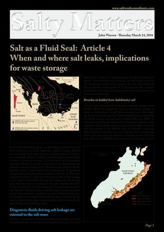
Figure 1. Hith Anhydrite isopach showing thickening from the UAE west into Saudi
Arabia and some of the main fields producing from Jurassic reservoirs in this region (in
part after Alsharhan and Kendall, 1994). Note the lack of Jurassic reservoirs to the east
of the Hith erosional edge showing the effectiveness of the saltern evaporite in holding
back substantial oil and gas columns sourced in Hanifa mudstones (after Warren, 2016).
Today
Mid Tertiary
Base Tertiary
Base Mid-Cret.
Base Jurassic
Not
mapped
100 km
South Oman
Salt Basin
Figure 2. Distribution and timing of charge in the oil and gas fields along the
highly productive eastern margin of the South Oman Salt Basin is controlled by
the retreating dissolution edge of the Neoproterozoic Ara Salt and the underly-
ing Huqf Fm. source rock, which became mature in the Cretaceous. Oil fields
shaded red, stars indicate gas fields (after Terken et al., 2001).
2. Page 2
and supergiant fields, including Ghawar in Saudi Arabia, which
is the largest single oil-filled structure in the world. Inherent
maintenance of the evaporite’s seal capacity also prevents vertical
migration from mature sub-Hith source rocks into potential res-
ervoirs in the overlying Mesozoic section across much of Saudi
Arabia and the western Emirates.However,toward the Hith seal
edge are a number of large fields supra-Hith fields, hosted in
Cretaceous carbonates,and a significant portion of the hydrocar-
bons are sourced in Jurassic carbonate muds that lie stratigraph-
ically below the anhydrite level (Figure 1).
The modern Hith Anhydrite edge is not the depositional margin
of the laterally extensive evaporite bed. Rather, it is a dissolution
edge, where rising basinal brines moving up and out of the basin
have thinned and altered the past continuity of this effective seal.
The process of ongoing dissolution allowing vertical leakage near
the edge of a subsurface evaporite interval, typifies not just the
edge of bedded salts but also the basinward edges of salt units
that are also halokinetic. The dissolution edge effect of the Ara
Salt and its basinward retreat over time are clearly seen along the
eastern edge of the South Oman Salt Basin where the time of
filling of the Permian-hosted reservoir structures youngs toward
the west (Figure 2).
Leakages associated with the margins of discrete diapir-
ic structures
Once formed, salt diapirs tend to focused upward escape of ba-
sinal fluid flows: as evidenced by: (1) localized development of
mud mounds and chemosynthetic seeps at depopod edges above
diapirs in the Gulf of Mexico (Figure 3a); (2) shallow gas anom-
alies clustered around and above salt diapirs in the North Sea
and (Figure 3b); (3) localized salinity anomalies around salt di-
apirs, offshore Louisiana and with large pockmarks above diapir
margins in West Africa (Cartwright et al., 2007). Likewise, in
the eastern Mediterranean region, gas chimneys in the Tertia-
ry overburden are common above regions of thinned Messinian
Salt, as in the vicinity of the Latakia Ridge (Figure 4).
Leakage of sub-salt fluids associated with salt welds and
halokinetic touchdowns
Whenever a salt weld or touchdown occurs, fluids can migrate
vertically across the level of a now flow-thinned or no-lon-
ger-present salt level. Such touchdowns or salt welds can be in
basin positions located well away from the diapir edge and are
a significant feature in the formation of many larger base-metal
and copper traps,as well as many depopod-hosted siliciclastic oil
and gas reservoirs (Figure 5: Warren 2016).
Caprocks are leaky
Any caprock indicates leakage and fractional dissolution have
occurred along the evaporite boundary (Figure 5). Passage of an
undersaturated fluid at or near the edge of a salt mass creates
a zone of evaporite dissolution residues, which in the case of
diapiric occurrences is called usually called a “caprock,”although
such diagenetic units do not only form a “cap” or top to a salt
structure.
www.saltworkconsultants.com
Two-wayTime(second)
2.0
2.5
3.0
3.5
4.0
4.5
5.0
3 km
Gaschimney
Leading thrust ahead
of the Latakia Ridge
Latakia Ridge
Messinian salt
Northwest Southeast
Salt breached
and leaking
Figure 4. Gas chimney present above the leading thrust of the Latakia Ridge (After
Bowman, 2011).
3. Page 3
Historically, in the 1920s and 30s, shallow
vuggy and fractured caprocks to salt diapirs
were early onshore exploration targets about
topographic highs in the Gulf of Mexico (e.g.
Spindletop). Even today, the density of drilling
and geological data derived from these onshore
diapiric features means many models of cap-
rock formation are mostly based on examples
in Texas and Louisiana. Onshore in the Gulf
of Mexico, caprocks form best in dissolution
zones at the outer, upper, edges of salt struc-
tures, where active cross-flows of meteoric wa-
ters are fractionally dissolving the salt. How-
ever, rocks composed of fractional dissolution
residues, with many of the same textural and
mineralogical association as classic Gulf of
Mexico caprocks, are now known to mantle the
deep sides of subvertical-diapirs in the North
Sea (e.g.,lateral caprock in the Epsilon Diapir)
and define the basal anhydrite (basal caprock)
that defines the underbelly of the Cretaceous
Maha Sarakham halite across the Khorat Pla-
teau in NE Thailand (Figures 5; Warren, 2016).
All “caprocks” are fractionally-dissolved accu-
mulations of diapir dissolution products and
form in zones of fluid-salt interaction and
leakage, wherever a salt mass is in contact with
undersaturated pore fluids (Figure 6). First to
dissolve is halite, leaving behind anhydrite res-
idues, that if the flushing waters can then con-
vert to gypsum and in the presence of sulphate
reducing bacteria to calcite.If the diapir experi-
ences another growth pulses the caprock can be
broken and penetrated by the rising salt. This
explains the fragments of caprock caught up
in shale sheaths or anomalous dark-salt zones,
as exemplified by less-pure salt-edge intersec-
tion units described as dark and anomalous salt
zones in the Gulf of Mexico diapirs
(as documented in Article 1).
Diagenetic fluids driving
salt leakage are internal
to the salt mass
Fluid entry in relation to chang-
es in the dihedral angle of halite is
well documented (Article 2). It was
first recorded by Lewis and Holness
(1996) who postulated, based on their
static-salt laboratory experiments;
“In sedimentary basins with normal
geothermal gradients, halite bodies at
depths exceeding 3 km will contain a
www.saltworkconsultants.com
Salt Weld
Fault zone or gumbo, commonly overpressured
Zone of overpressure higher beneath
salt canopy
Caprock and brine halo zones from salt dissolution
(pore waters tends to be reducing & high salinity)
Overpressured zone (shale dominant)
Zone of fluid transfer across a salt weld or
a zone of thinned (residual salt < 10 m thick)
Halokinetic Salt
Figure 5. Zones of leakage and insoluble residue (caprock, lateral caprock and basal caprock) are created at
the salt edge in zones of undersaturated circum-salt fluid focus (after Warren, 2016).
A.
B.
TriassicJur.LowerCret.
Upp.
Cret.
Teritary
9/2-8TS4
Basement
Epsilon diapir Epsilon diapir detail Fluid flow model
Lower
Cret.
Upper
Permian
diapiric
salt
Jurass.
T3
T4
9/2-8TS4
Anhydritic
lateral caprock
Crestal caprock
(active phreatic)
Diapir
Surface
Lateral
caprock
(meso-
genetic)
Basement
Diapir Mode. Epsilon (squeezed) diapir, North Sea, as an example of lateral caprock formed via mesogenetic
fluid flshing and crestal caprock via active phreatic flushing
Limit of saline waters
from immediate dissolution
of bedded halite mixed with
basinal waters (greenbed halo)
Direction of interface retreat
created by salt dissolution
Basal anhydrite
Thick basin-wide
bedded salts
(100s m - km thick)
Escaping
basinal
waters
Saline seep
Fault conduit
Lateralundersaturated
inflow
Saline
seeps
Halite and bittern
salts dissolve
along underside
of bed
Anhydrite dissolves on
underside of bed; organics
and other residues,
including sulphides,
accumulate
Anhydrite nodules accrete as
nodular mosaic (insolubles)
on upper side of basal
anhydrite
aquifer
Basal
anhydrite
Baseof
lowersalt
TopofKhok
KruatGroup
≈1m
Halite undersaturated
water seeps through the
basal anhydrite bed
Na, Cl, K, (Mg?)
ions permeate out of
unit via inter-nodule
permeability
Basinwide Mode. Basal Anhydrite Maha Sarakham, Basal Anhydrite , as an example of basal caprock formed via
mesogenetic fluid flushing as the rise of basinal waters of the Khorat group is focused along the salt’s underside
Figure 6. Caprock also forms in non-crestal positions. A) Basal anhydrite beneath Maha Sara-
kham salt, Thailand (after Warren, 2016) B) Lateral caprock- Epsilon diapir, North Sea (after
Jackson and Lewis, 2012).
4. Page 4
www.saltworkconsultants.com
stable interconnected brine-filled porosity, resulting in permea-
bilities comparable to those of sandstones”. Extrapolating from
their static halite pressure experiments they inferred that halite,
occurring at depths of more than ≈3 km and temperatures above
200 °C, has a uniform intrasalt pore system filled with brine, and
therefore relatively high permeabilities.
In the real world of the subsurface,salt seals can hold back signif-
icant hydrocarbon columns down to depths of more than 6-7 km
(see case studies in Chapter 10 in Warren, 2016 and additional
documentation the SaltWork database). Based on a compilation
of salt-sealed hydrocarbon reservoirs, trans-salt leakage across
75-100 metres or more of pure salt does not occur at depths less
than 7-8 km, or temperatures of less than 150°C. In their work
on the Haselbirge Formation in the Alps, Leitner et al. (2001)
use a temperature range >100 °C and pressures >70 MPa as de-
fining the onset of the dihedral transition.
It seems that across much of the mesogenetic realm, a flowing
and compacting salt mass or bed can maintain seal integrity to
much greater depths than postulated by static halite percolation
experiments. In the subsurface, there may be local pressured-in-
duced changes in the halite dihedral angle within the salt mass,
as seen in the Ara Salt in Oman, but even there, there is no ev-
idence of the total km-scale salt mass transitioning into a leaky
aquifer via changes in the halite dihedral angle (Kukla et al.,
2011). But certainly, as we move from the diagenetic into the
metamorphic realm, even thick pure salt bodies become perme-
able across the whole salt mass. Deeply buried and pressured salt
ultimately dissolves as it transitions into various meta-evaporite
indicator minerals and zones (Chapter 14, Warren, 2016).
When increasing pressure and temperature changes the halite
dihedral angle in the diagenetic realm, then supersaturated hy-
drocarbon-bearing brines can enter salt formations to create
naturally-hydrofractured “dark-salt”. As we discussed in Ar-
ticle 2, pressure-induced changes in dihedral angle in the Ara
Salt of Oman create black salt haloes that penetrate, from the
overpressured salt-encased carbonate sliver source, up to 50 or
more meters into the adjacent halite (Schoenherr et al. 2007a,
b). Likewise, Kettanah, 2013 argues Argo Salt of eastern Canada
also has leaked, based on the presence of petroleum-fluid inclu-
sions (PFI) and mixed aqueous and fluid inclusions (MFI) in
the recrystallised halite (Figure 7 - see also Ara “black salt” core
photos in Article 2 of this series).
Both these cases of dark-salt leakage (Ara and Argo salts) oc-
cur well within the salt mass, indicating the halokinetic salt has
leaked or transmitted fluids within zones well away from the
salt edge. In the case of the Argo salt, the study is based on drill
cuttings collected across 1500 meters of intersected salt at depths
of 3-4 km. Yet, at the three km+ depths in the Argo Salt where
salt contains oil and bitumen, the total salt mass still acts a seal,
implying it must have regained or retained seal integrity, after it
leaked. Not knowing the internal fold geometries in any deeply
buried salt mass, but knowing that all flowing salt masses are in-
ternally complex (as seen in salt mines and namakiers),means we
cannot assume how far the hydrocarbon inclusions have moved
within the salt mass, post-leakage. Nor can we know if, or when,
any salt contact occurred with a possible externally derived hy-
drocarbon-bearing fluid source, or whether subsequent salt flow
lifted the hydrocarbon-inclusion-rich salt off the contact surface
as salt flowed back into the interior of the salt mass.
Thus, with any hydrocarbon-rich occurrence in a halokinetic salt
mass, we must ask the question; did the salt mass once hydrof-
racture (leak) in its entirety, or did the hydrocarbons enter lo-
cally and then as the salt continued to flow, that same hydrocar-
bon-inclusion-rich interval moved into internal drag and drape
folds? In the case of the Ara Salt, the thickness of the black salt
penetration away from its overpressured source is known as it is a
core-based set of observations. In the Ara Salt at current depths
of 3500-4000 m, the fluid migration zones extend 50 -70 meters
out from the sliver source in salt masses that are hundreds of
metres thick (Kukla et al., 2011; Schoenherr et al., 2007).
So how do we characterize leakage extent in
a buried salt mass without core?
Dark salt, especially if it contains hydrocarbons, clearly indicates
fluid entry into a salt body in the diagenetic realm. Key to con-
siderations of hydrocarbon trapping and long-term waste stor-
age is how pervasive is the fluid entry, where did the fluid come
from, and what are the likely transmission zones in the salt body
(bedded versus halokinetic)?
In an interesting recent paper documenting and discussing salt
leakage, Ghanbarzadeh et al., 2015 conclude:
Waymouth A-45
(3645 m)
Waymouth A-45
(3645 m)
Waymouth A-45 (3410 m)
Figure 7. Halite crystals of the Weymouth-A45 well showing halite crystal aggregates with
sutured polyhedal contacts (A, B). C) shows perpendicular cleavage planes and assemblages
of primary aqueous fluid inclusions (AFI) between cleavages planes that are parallel to
growth zones, as well as a linearly oriented assemblages of secondary petroleum fluid
inclusions (PFI) trapped along healed fractured zones (after Kettanah, 2013). The sampled
halite is once again impermeabe although it contains hydrocarbon inclusions.
5. Page 5
“The observed hydrocarbon distributions in rock salt require that
percolation occurred at porosities considerably below the static
threshold due to deformation-assisted percolation.Therefore,the
design of nuclear waste repositories in salt should guard against
deformation-driven fluid percolation. In general, static perco-
lation thresholds may not always limit fluid flow in deforming
environments.”
Their conclusions are based on lab experiments on static salt
and extrapolation to a combination of mud log and wireline
data collected from a number of wells that intersected salt al-
lochthons in Louann Salt in the Gulf of Mexico. Their lab data
on changing dihedral angles inducing leakage or percolation in
static salt confirms the experiments of Holness and Lewis (1996
– See Article 2). But they took the implications of dihedral an-
gle change further, using CT imagery to document creation of
interconnected polyhedral porosity in static salt at higher tem-
peratures and pressures (Figure 8). They utilise Archies Law
and resistivity measures to calculate inferred porosity, although
it would be interesting what values they utilise for cementation
exponent (depends on pore tortuosity) Sw and saturation expo-
nent. Assuming the standard default values of m = 2 and n =2
when applying Archies Law to back calculate porosity spreads in
halite of assumed Sw are likely incorrect.
They then relate their experimental observations to wireline
measurements and infer the occurrence of interconnected pores
in Gulf of Mexico salt based on this wireline data. Key to their
interpretation is the deepwater well GC8 (Figure 9), where they
use a combination of a resistivity, gas chromatograms, and mud
log observations to infer that hydrocarbons have entered the
lower one km of a 4 km thick salt section, via dihedral-induced
percolation.
I have a problem in accepting this leap of faith from laboratory
experiments on pure salt observed at the static decimeter-scale
of the lab to the dynamic km-scale of wireline-inferred obser-
vations in a salt allochthon in the real world of the offshore in
deepwater salt Gulf of Mexico. According to Ghanbarzadeh et
al.,2015,the three-part gray background in Figure 9 corresponds
to an upper no-percolation zone (dark grey), a transition zone
(moderate grey) and a lower percolation zone (light grey). This
they then infer to be related to changes in dihedral angle in the
halite sampled in the well (right side column). Across the data
columns, what the data in the GC8 well show is: A) Gamma
log; allochthon salt has somewhat higher API values at depths
shallower than 5000 m; B) Resistivity log, a change in resistivity
to higher values (i.e., lower conductivity) with a change in the
same cross-salt depth range as seen in the gamma log, beginning
around 5100 m; C) Gas (from sniffer), shows a trend of decreas-
ing gas content from the base of salt (around 6200 m) up to a
depth around 4700 m, then relatively low values to top salt, with
an interval that is possibly shalier interval (perhaps a suture - see
below) that also has a somewhat higher gas content ; D) Gas
chromatography, the methane (CH4) content mirrors the total
gas trends, as do the other gas phases, where measured; E) Mud
660 µm
T=100°CP=20MPa
(ExperimentI)
T=275°CP=100MPa
(ExperimentII)
IsolatedtetrahehralØConnectedpolyhedralØ
isolated
pores
No
leakage
Leakage
(percolation)
connected
pores
θ > 60°
θ ≤ 60°
No percolation
(no leakage)
Percolation
(leakage)
Experiment I
Experiment II
0 1 2 3
Porosity (%)
4 5
100
90
80
70
60
50
40
30
20
10
0
Dihedralangle(θ)
Ex. I
Ex. II
A. B.
Figure 8. Halite dihedral angle changes and the creation of connected intercrystalline polyhedal pores at higher temperatures and
pressures (after Ghanbarzadeh et al., 2015). A) Hydrostatic experiments on synthetic performed at P = 20 MPa and T = 100°C (Exp-I) and P
=100 MPa and T = 275°C (Exp-II). Shows their 3D reconstruction of the pore network at assumed static textural equilibrium; all edges of
the 3D volumes correspond to 660 mm. The skeletonized pore network was extracted from the reconstructed 3D volume; colored
according to local pore-space-inscribed radii, with warmer colors indicating larger radii. B) Distribution of apparent dihedral angles in the
two experiments plotting the Exp-I and Exp-II ponints in a porosity to dihedral angle plot space ,with the percolation threshold (brown
versus white shading) calculated from static pore-scale theory . Left side inset and y axis shows the details of automated dihedral angle
extraction from 2D images.They show also the median value of dihedral angles and the estimated errors based on the 95% confidence
interval. Bottom inset and x axis shows their calculated porosity in natural rock salt inferred from resistivity logs using Archies Law.
www.saltworkconsultants.com
6. Page 6
Log (fluorescence response), dead oil is variably present from
base of salt up to 5000 m, oil staining, oil cut and fluorescence
(UV) are variably present from base salt up to a depth of 4400 m.
On the basis of the presented log data, one can infer the lower
kilometer of the 4 km salt section contains more methane, more
liquid hydrocarbons, and more organic material/kerogen com-
pared to the upper 3 km of salt.Thus,the lower section of the salt
intersected in the GC8 well is likely to be locally rich in zones
of dark or anomalous salt, compared with the overlying 3 km of
salt. What is not given in figure 9 is any information on likely
levels of non-organic impurities in the salt, yet this information
would have been noted in the same mud log report that listed
hydrocarbon levels in the well. In my opinion, there is a lack of
lithological information on the Gulf of Mexico salt in the Ghan-
barzadeh et al. paper, so one must ask; “does the lower kilometer
of salt sampled in the GC8 well, as well as containing hydrocar-
bons also contain other impurities like shale, pyrite, anhydrite,
etc. If so, potentially leaky intervals could be present that were
emplaced by sedimentological processes
unrelated to changes in the dihedral an-
gle of the halite (see next section).
Giving information that is standard in
any mud-log cuttings description (such
as the amount of anhydrite, shale, etc
that occur in drill chips across the salt
mass), would have added a greater level
of scientific validity to to Ghanbarzadeh
et al.’s inference that observed changes
in hydrocarbon content up section, was
solely facilitated by changes in dihedral
angle of halite facilitating ongoing leak-
age from below the base of salt and not
due to the dynamic nature of salt low
as the allochthon or fused allochthons
formed. Lithological information on salt
purity is widespread in the Gulf of Mexi-
co public domain data.For example,Fig-
ure 10 shows a seismic section through
the Mahogany field and the intersection
of the salt by the Phillips No. 1 discov-
ery well (drilled in 1991).This interpret-
ed section, tied to wireline and cuttings
information, was first published back in
1995 and re-published in 2010. It shows
intrasalt complexity,which we now know
typifies many sutured salt allochthon and
canopy terrains across the Gulf of Mexi-
co salt province. Internally, Gulf of Mex-
ico salt allochthons, like others world-
wide, are not composed of pure halite,
just as is the case in the onshore struc-
tures discussed in the context of dark salt
zones in article 1. Likely, a similar lack of
purity and significant structural and lith-
ological variation typifies most if not all
of the salt masses sampled by the Gulf of
Mexico wells listed in the Ghanbarzadeh
et al.paper,including the key GC8 well (Figure 9).This variation
in salt purity and varying degrees of local leakage is inherent to
the emplacement stage of all salt allochthons world-wide. It is
set up as the salt flow (both gravity spreading and gravity glid-
ing) occurs at, or just below the seafloor, fed by varying combi-
nations of extrusion or thrusting, which moves salt out and over
the seabed (Figure 11).
Salt, when it is flowing laterally and creating a salt allochthon,
is in a period of rapid breakout (Figure 11; Hudec and Jackson,
2006, 2007; Warren 2016). This describes the situation when a
rising salt sheet rolls out over its base, much in the same way a
military tank moves out over its track belt. As the salt spreads,
the basal and lateral salt in the expanding allochthon mass, is
subject to dissolution, episodic retreat, collapse and mixing with
seafloor sediment, along with the entry of compactional fluids
derived from the sediments beneath. Increased impurity lev-
els are particularly obvious in disturbed basal shear zones that
www.saltworkconsultants.com
Figure 9. Petrophysical observations using wireline well logs and mud logs data to
constrain the fluid distribution and connectivity in 4 km of saltintersected in the
well GC8 from the deep water Gulf of Mexico (after Ghanbarzadeh et al., 2015). (A)
Gamma-ray log, (B) electrical resistivity, (C) total hydrocarbons gas, (D) gas
chromatography, (E) hydrocarbon indications in the mud log (FL, fluorescence;
OS, oil stain; DO, dead oil; and OC, oil cut) in mud logs, and (F) the dihedral angle
inferred from experimental data. Shading around each curve shows the measure-
ment error and average fluctuations in data.
7. Page 7
transition downward into a gumbo zone (Figure
12a), but also mantle the sides of subvertical salt
structures, and can evolve by further salt disso-
lution into lateral caprocks and shale sheaths
(Figure 6).
In expanding allochthon provinces, zones of
non-halite sediment typically define sutures
within (autosutures; Figure 12b) or between salt
canopies (allosutures; Figure 12c).These sutures
are encased in halite as locally leaky, dark salt
intervals, and they tend to be able to contrib-
ute greater volumes of fluid and ongoing intra-
salt dissolution intensity and alteration where
the suture sediment is in contact with outside-
the-salt fluids. Allochthon rollout, with simul-
taneous diagenesis and leakage, occurs across
intrasalt shear zones, or along deforming basal
zones. In the basal part of an expanding alloch-
thon sheet the combination of shearing, sealing,
and periodic leakage creates what is known as
“gumbo,” a term that describes a complex, vari-
ably-pressured, shale-rich transition along the
www.saltworkconsultants.com
Figure 10. Interpreted seismic across the Mahogany Discovery, Gulf of Mexico (after Harrison et al., 2010). This was the
petroleum industry's first commercial subsalt oil development in the Gulf of Mexico and even in this 1990s vintage
seismic, the intrasalt complexity is evident both in the seismic section and along the well trajectory. Internally, Gulf of
Mexico halite is not made up of halite with only hydrocarbons as impurities.
B) Plug-fed extrusion C) Source-fed thrustA) Plug-fed Thrust
Salt plug
Extrusive advance
Open-toed advance
Thrust advance
Salt plug Autochthonous source layer
Thrust advance (tectonic)Thrust advance (tectonic)
Open-toed advance
Thrust advance (driven
by salt expulsion)
Open-toed advance
Thick overburden
Future thrust
Shortening
BreakoutBreakout
BurialBreakoutFull burial
Open-toe
Diapir roof thrust
Partial burial
Autochthonous source layer
Thin roof
Breakout
Open-toe
Thrust advance (driven
by salt expulsion)
Sheet pinned
BreakoutBurial
Thin roof
Thick overburdenSheet pinned
Thick
overburdenSheet pinned
Thick
overburden
Figure 11. Emplacement of salt sheets (allochthons; after Hudec and Jackson 2006). Most salt sheets advance by a time-related sequence
of extrusion, open-toed advance, and thrusting. These modes may combine in many ways over the life span of a salt sheet, but three
evolutionary sequences (or lineages) are particularly common. (a) Plug-fed extrusions. (b) Plug-fed thrusts, and (c) Source-fed thrusts (see
also Figure 12a for detail on basal shear).
8. Page 8
basal margin of most salt allochthons in the Gulf of Mexico
(Figure 12a). Away from suture zones, as more allochthon salt
rolls out over the top of earlier foot-zones to the spreading salt
mass, the inner parts of the expanding and spreading allochthon
body tend toward greater internal salt purity (less non-salt and
dissolution residue sediment,as well as less salt-entrained hydro-
carbons and fluid inclusion).
At the salt’s upper
contact, the spreading
salt mass may carry its
overburden with it, or
it may be bare topped
(aka open-toed; Figure
11). In either case, once
salt movement slows
and stops, a caprock
carapace starts to form
that is best developed
wherever the salt edge
is flushed by undersatu-
rated pore waters (Fig-
ure 6). Soon after its
emplacement, the basal
zone of a salt alloch-
thon acts a focus for ris-
ing compactional fluids
coming from sediments
beneath. So, even as it is
still spreading, the lower
side of the salt sheet is
subject to dissolution,
and hydrocarbon entry,
often with remnants
of the same hydrocar-
bon-entraining brines
leaking to seafloor about
the salt sheet edge. As
the laterally-focused
subsalt brines escape to
the seafloor across zones
of thinned and leaky
salt or at the allochthon
edge, they can pond to
form chemosynthetic
DHAL (Deepsea Hy-
persaline Anoxic Lake)
brine pools (Figure 3a).
Such seep-fed brine
lakes typify the deep sea
floor in the salt alloch-
thon region of conti-
nental slope and rise in
the Gulf of Mexico and
the compressional salt
ridge terrain in the cen-
tral and eastern Medi-
terranean. If an alloch-
thon sheet continues
to expand, organic-rich
DHAL sediments and
fluids become part of the basal shear to the salt sheet (Figure
12a).
Unfortunately, Ghanbarzadeh et al., 2015 did not consider the
likely geological implications of salt allochthon emplacement
www.saltworkconsultants.com
Amoco #1
Vermilion
356
Anadarko #1
Vermilion
349
Unocal #1
Ship Shoal
360
10,000 ft
15,000 ft
5,000 ft
20,000 ft
25,000 ft
Fault gouge
(shale sheath)
Rotated, dissolved and
sheared base of salt
atop ”gumbo”
1
2
3
4
5
6
7
8
9
10
Sealevel Sealevel
15,000 ft
Condensed rafted section correlates
with layer 5 and older
5
9
1
2
3
1
2
3
4
6
7
8
4
2000 m
4000 m
6000 m
A) Rollout model of base of salt and creation of underlying gumbo (can become
a suture if adjacent salt canopies overlap
B) Autosutures (zones of internal
non-salt sediment and black salt)
C) Allosutures (zones of internal
non-salt sediment and black salt)
Frontal escarpment
Apical allosuture lineMinor suturing
Terminal suture point
Peripheral plain
Allosuture
Suture dips toward
overiding sheet
Feeder
Salt Sheet A
Feeder
Salt Sheet B
Apical allosuture line
Terminal suture point
Basal suture point
Peripheral plain
Major suturing
Boudinaged and torn
sediments in suture zone
Feeder
Salt Sheet A
Feeder
Salt Sheet BListric allosuture
Time
Passive diapir
Salt sheet
feeder
Diapir pinched shut
Extension
Shortening
Aggrading peripheral
plain acts as allochthon
buttress (R>A)
Aggrading peripheral
plain acts as allochthon
buttress (R>A)
Fold belt parallel
with apical suture line
Autosutures localised by
weak zones in roof
Salt expelled
from beneath
overriding lobe
Autosuture
Figure 12. Geological settings that can create“leaky”base of salt or intrasalt sediment sutures. A) Cross section view
of salt allochton with a basal thrust fault defining the rising compressional nose of the salt sheet. Relevant Gulf of
Mexico wells are placed schematically on this section (after Harrison and Patton (1995). B) Autosutures: the roof of a
salt sheet shortens where sheet advance is buttressed by peripheral plain or by another salt sheet. Overriding auto-
sutures may initiate at any zone of weakness in the roof, especially pre-existing reactive diapirs formed by previous
stretching as the salt sheet spreads. As it is overridden from the rear, the front of the roof depressed into the salt. C)
Asymmetric allosutures. As one salt sheet overridesthe other, sediments in the suture are depressed, stretched, and
dismembered to form boudins in the salt. These sediments eventually tear off from the basal suture line (B anc C
after Dooley et al., 2012).
9. Page 9
mechanisms and how this likely explains much of the geologi-
cal character seen in wireline signatures across wells intersecting
salt in the Gulf of Mexico. Rather, they assume the salt system
and the geological character they infer as existing in the lower
portions of Gulf of Mexico salt masses,are tied to post-emplace-
ment changes in salt’s dihedral angle in what they consider as
relatively homogenous and pure salt masses. They modeled the
various salt masses in the Gulf of Mexico as static, with upward
changes in the salt purity indicative of concurrent hydrocarbon
leakage into salt and facilitated by altered dihedral angles in
the halite. A basic tenet of science is “similarity does not mean
equivalence.”Without a core from this zone, one cannot assume
hydrocarbon occurrence in the lower portions of Gulf of Mexico
salt sheets is due to changes in dihedral angle. Equally, if not
more likely, is that the wireline signatures they present in their
paper indicate the manner in which the lower part of a salt al-
lochthon has spread. To me, it seems that the Ghanbarzadeh et
al. paper argues for caution in the use of salt cavities for nuclear
waste storage for the wrong reasons.
Is nuclear waste storage in salt a safe, viable
long-term option?
Worldwide, subsurface salt is an excellent seal, but we also know
that salt does fail, that salt does leak, and that salt does dissolve,
especially in intrasalt zones in contact with “outside” fluids.
Within the zone of anthropogenic access for salt-encased waste
storage (depths of 1-2km subsurface) the weakest points for po-
tential leakage in a salt mass,both natural and anthropogenic,are
related to intersection with, or unplanned creation of, unexpect-
ed fluid transmission zones and associated entry of undersatu-
rated fluids that are sourced outside the salt (see case histories in
Chapter 7 and 13 in Warren, 2016).This intersection with zones
of undersaturated fluid creates zones of weakened seal capacity
and increases the possibility of exchange and mixing of fluids de-
rived both within and outside the salt mass. In the 1-2 km depth
range, the key factor to be discussed in relation to dihedral angle
change inducing percolation in the salt, will only be expressed
as local heating and fluid haloes in the salt about the storage
cavity. Such angle changes are tied to a thermal regime induced
by long-term storage of medium to high-level radioactive waste.
I use an ideal depth range of 1-2 km for storage cavities in salt
as cavities located much deeper than 2 km are subject to com-
pressional closure or salt creep during the active life of the cavity
(active = time of waste emplacement into the cavity). Cavities
shallower than 1 km are subject to the effects of deep phreat-
ic circulation. Salt-creep-induced partial cavity closure, in a salt
diapir host, plagued the initial stages of use of the purpose-built
gas storage cavity known as Eminence in Mississippi. In the ear-
ly 1970s, this cavity was subject to a creep-induced reduction in
cavity volume until gas storage pressures were increased and the
cavern shape re-stabilised. Cavities in salt shallower than 1 km
are likely to be located in salt intervals that at times have been al-
tered by cross flows of deeply-circulating meteoric or marine-de-
rived phreatic waters. Problematic percolation or leakage zones
(aka anomalous salt zones), Which can occur in some places in
salt masses in the 1-2 km depth range, are usually tied to vary-
www.saltworkconsultants.com
ing combinations of salt thinning, salt dissolution or intersec-
tion with unexpected regions of impure salt (relative aquifers).
In addition to such natural process sets, cross-salt leakage can
be related to local zones of mechanical damage, tied to processes
involved in excavating a mine shaft, or in the drilling and casing
of wells used to create a purpose-built salt-solution cavity. Many
potential areas of leakage in existing mines or brine wells are the
result of poorly completed or maintained access wells, or inter-
sections with zones of “dark salt,”or with proximity to a thinned
salt cavity wall in a diapir, as documented in articles 1 and 2 (and
detailed in various case studies in Chapters 7 and 13 in Warren
2016).
In my opinion, the history of extraction, and intersections with
leakage zones, during the life of most of the world’s existing salt
mines means conventional mines in salt are probably not appro-
priate sites for long-term radioactive waste storage. Existing salt
mines were not designed for waste storage, but to extract salt
or potash with mining operations often continuing in a partic-
ular direction along an ore seam until the edge of the salt was
approached or even intersected. When high fluid transmission
zones are unexpectedly intersected during the lifetime of a salt
mine, two things happen; 1) the mine floods and operations
cease, or the flooded mine is converted to a brine extraction fa-
cility (Patience Lake) or, 2) the zone of leakage is successfully
grouted and in the short term (tens of years) mining continues
(Warren, 2016).
For example, in the period 1906 to 1988, when Asse II was an
operational salt mine, there were 29 documented water breaches
that were grouted or retreated from. Over the long term, these
same water-entry driven dissolution zones indicate a set of nat-
ural seep processes that continued behind the grout job. This is
true in any salt mine that has come “out of the salt” and outside
fluid has leaked into the mine. “Out-of-salt” intersections are
typically related to fluids entering the salt mass via dark-salt or
brecciated zones or shale sheath intersections (these all forms of
anomalous salt discussed in article 1 and documented in the case
studies discussed in Chapter 13 in Warren 2016).
I distinguish such “out-of-salt” fluid intersections from “in-salt”
fluid-filled cavities. When the latter is cut, entrained fluids drain
into the mine and then flow stops. Such intersections can be
dangerous during the operation of a mine as there is often ni-
trogen, methane or CO2 in an “in-the-salt” cavity, so there is
potential for explosion and fatalities. But, in terms of long-term
and ongoing fluid leakage “in-salt” cavities are not a problem.
Ultimately, because “out-of-salt” fluid intersections are part of
the working life of any salt mine, seal integrity in any mine con-
verted to a storage facility will fail. Such failures are evidenced
by current water entry problems in Asse II Mine, Germany
(low-medium level radioactive waste storage) and the removal
of the oil formerly stored in the Weeks Island strategic hydro-
carbon facility,Texas. Weeks Island was a salt mine converted to
oil storage. After the mine was filled with oil, expanding karst
cavities were noticed forming at the surface above the storage
area. Recovery required a very expensive renovation program
that ultimately removed more than 95% of the stored hydrocar-
10. Page 10
bons. And yet, during the active life
of the Weeks Island Salt Mine, the
mine geologists had mapped “black
salt” occurrences and tied them to
unwanted fluid entries that were
then grouted. Operations to block or
control the entry of fluids were suc-
cessful, and salt extraction continued
apace. This information on fluid en-
try was available well before the salt
mine was purchased and converted to
a federal oil storage facility. However,
in the 1970s when the mine was con-
verted, our knowledge of salt proper-
ties and salt’s stability over the longer
term was less refined than today.
Worldwide,the biggest problem with
converting existing salt mines to low
to medium level nuclear waste stor-
age facilities is that all salt mines are
relatively shallow, with operating
mine depth controlled by tempera-
tures where humans can work (typi-
cally 300-700 m and always less than
1.1 km).This relatively shallow depth
range, especially at depths above 500
m, is also where slowly-circulating
subsurface or phreatic waters are dis-
solving halite to varying degrees,This
is where fluids can enter the salt from
outside and so create problematic
dark-salt and collapse breccia zones
within the salt. In the long-term
(hundreds to thousands of years)
these same fluid access regions have
the potential to allow stored waste fluids to escape the salt mass,
Another potential problem with long-term waste storage in
many salt mines, and in some salt cavity hydrocarbon storage
facilities excavated in bedded (non-diapiric) salt, is the limited
thickness of a halite beds across the depth range of such con-
ventional salt mines and storage facilities. Worldwide, bedded
ancient salt tends to be either lacustrine or intracratonic, and
individual halite units are no more than 10-50 m thick in stacks
of various saline lithologies.That is, intracratonic halite is usually
interlayered with laterally extensive carbonate, anhydrite or shale
beds, that together pile into bedded saline successions up to a
few hundred metres thick (Warren 2010). The non-halite inter-
layers may act as potential long-term intrasalt aquifers,especially
if connected to non-salt sediments outside the halite (Figure 13).
This is particularly true if the non-salt beds remain intact and
hydraulically connected to up-dip or down-dip zones where the
encasing halite is dissolutionally thinned or lost. Connection to
such a dolomite bed above the main salt bed, in combination
with damaged casing in an access well, explains the Hutchison
gas explosion (Warren, 2016). Also, if there is significant local
heating associated with longer term nuclear waste storage in
such relatively thin (<10-50 m) salt beds, then percolation, re-
lated to heat-induced dihedral angle changes, may also become
relevant over the long-term (tens of thousands of years), even in
bedded storage facilities in 1-2 km depth range.
Now what?
Creating a purpose-built mine for the storage of low-level waste
in a salt diapir within the appropriate depth range of 1-2 km is
preferred approach and a much safer option compared to the
conversion of existing mines in diapiric salt, but is likely to pro-
hibitively expensive. To minimise the potenial of unwanted flu-
id ingress, the entry shaft should be vertical, not inclined. The
freeze-stabilised “best practice” vertical shaft currently being
constructed by BHP in Canada for its new Jansen potash mine
(bedded salt) is expected to cost more than $1.3 billion. If a pur-
pose-built mine storage facility were to be constructed for low to
medium level waste storage in a salt diapir,then it should operate
a depth of 800-1000m.Ideally,such a purpose-built mine should
also be located hundreds of metres away from the edges of salt
mass in a region that is not part of an area of older historical salt
extraction operations. At current costings, such a conventional-
ly-mined purpose-built storage facility for low to medium level
radioactive waste is not economically feasible.
www.saltworkconsultants.com
Geotechnicallyfavourable
(cavernisenclosedbysalt)
Geotechnicallylessfavourable
(cavernnotfullyenclosed)
Salt dome (diapiric)
Salt breccia (tectonic)Thin bedded salt
Thick bedded salt
fault
non-salt
non-salt
rock-salt
surface
salt
area influenced
by cavern cavern
Figure 13. Schematic summarising geotechnically favourable and less favourable scenar-
ios for waste storage in salt (after Gillhaus, 2010; Warren 2016).
11. Page 11
This leaves purpose-built salt-solution cavities excavated within
thick salt domes at depths of 1-2 km; such purpose-built cavi-
ties should be located well away from the salt edge and in zones
with no nearby pre-existing brine-extraction cavities or oil-field
exploration wells. This precludes most of the onshore salt dia-
pir provinces of Europe and North America, which are located
in high population areas and can have century-long histories
of poorly documented salt and brine extraction and petroleum
wells. Staying “in-the-salt” is an ongoing problem in these re-
gions (see case histories in chapters 7 and 13 in Warren, 2016.
References
Alsharhan,A.S.,and C.G.S.C.Kendall,1994,Depositional set-
ting of the Upper Jurassic Hith Anhydrite of the Arabian Gulf;
an analog to Holocene evaporites of the United Arab Emirates
and Lake MacLeod of Western Australia: Bulletin-American
Association of Petroleum Geologists, v. 78, p. 1075-1096.
Andresen, K. J., M. Huuse, N. H. Schodt, L. F. Clausen, and L.
Seidler, 2011, Hydrocarbon plumbing systems of salt minibasins
offshore Angola revealed by three-dimensional seismic analysis:
AAPG Bulletin, v. 95, p. 1039-1065.
Bowman, S. A., 2011, Regional seismic interpretation of the hy-
drocarbon prospectivity of offshore Syria: GeoArabia, v. 16, p.
95-124.
Cartwright, J., M. Huuse, and A. Aplin, 2007, Seal bypass sys-
tems: American Association Petroleum Geologists - Bulletin, v.
91, p. 1141-1166.
Davison,I.,2009,Faulting and fluid flow through salt: Journal of
the Geological Society, v. 166, p. 205-216.
Dooley, T. P., M. R. Hudec, and M. P. A. Jackson, 2012, The
structure and evolution of sutures in allochthonous salt: Bulletin
American Association Petroleum Geologists,v.96,p.1045-1070.
Ghanbarzadeh, S., M. A. Hesse, M. Prodanović, and J. E. Gard-
ner, 2015, Deformation-assisted fluid percolation in rock salt:
Science, v. 350, p. 1069-1072.
Gillhaus, A., 2010, Natural gas storage in salt caverns - Sum-
mary of worldwide projects and consequences of varying stor-
age objectives and salt formations, in Z. H. Zou, H. Xie, and
E. Yoon, eds., Underground Storage of CO2 and Energy, CRC
Press, Boca Raton, Fl., p. 191-198.
Harrison, H., and B. Patton, 1995, Translation of salt sheets by
basal shear: Proceedings of GCS-SEPM Foundation 16th An-
nual Research Conference, Salt Sediment and Hydrocarbons,
Dec 3-6, 1995, p. 99-107.
Holly Harrison, Dwight ‘Clint’ Moore, and P. Hodgkins, 2010,
A Geologic Review of the Mahogany Subsalt Discovery: A
Well That Proved a Play (The Mahogany Subsalt Discovery:
A Unique Hydrocarbon Play, Offshore Louisiana): Search and
Discovery Article #60049 Posted April 28, 2010, Adapted from
presentation at AAPG Annual Convention, 1995, and from an
extended abstract prepared for presentation at GCS-SEPM
Foundation 16th Annual Research Conference, “Salt, Sediment
and Hydrocarbons,” December 3-6, 1995.
Hudec, M. R., and M. P. A. Jackson, 2006, Advance of alloch-
thonous salt sheets in passive margins and orogens: American
Association Petroleum Geologists - Bulletin,v.90,p.1535-1564.
Hudec, M. R., and M. P. A. Jackson, 2007, Terra infirma: Un-
derstanding salt tectonics: Earth-Science Reviews, v. 82, p. 1-28.
Jackson,C.A.L.,and M.M.Lewis,2012,Origin of an anhydrite
sheath encircling a salt diapir and implications for the seismic
imaging of steep-sided salt structures,Egersund Basin,Northern
North Sea: Journal of the Geological Society, v. 169, p. 593-599.
Kettanah, Y. A., 2013, Hydrocarbon fluid inclusions in the Argo
salt, offshore Canadian Atlantic margin: Canadian Journal of
Earth Sciences, v. 50, p. 607-635.
Kukla, P., J. Urai, J. K. Warren, L. Reuning, S. Becker, J. Schoen-
herr, M. Mohr, H. van Gent, S. Abe, S. Li, Desbois, G. Zsolt
Schléder, and M. de Keijzer, 2011, An Integrated, Multi-scale
Approach to Salt Dynamics and Internal Dynamics of Salt
Structures: AAPG Search and Discovery Article #40703.
Leitner, C., F. Neubauer, J. L. Urai, and J. Schoenherr, 2011,
Structure and evolution of a rocksalt-mudrock-tectonite: The
haselgebirge in the Northern Calcareous Alps: Journal of Struc-
tural Geology, v. 33, p. 970-984.
Lewis, S., and M. Holness, 1996, Equilibrium halite-H2O di-
hedral angles: High rock salt permeability in the shallow crust:
Geology, v. 24, p. 431-434.
Schoenherr, J., J. L. Urai, P. A. Kukla, R. Littke, Z. Schleder, J.-
M. Larroque, M. J. Newall, N. Al-Abry, H. A. Al-Siyabi, and Z.
Rawahi, 2007, Limits to the sealing capacity of rock salt: A case
study of the infra-Cambrian Ara Salt from the South Oman salt
basin: Bulletin American Association Petroleum Geologists, v.
91, p. 1541-1557.
Terken,J.M.J.,N.L.Frewin,and S.L.Indrelid,2001,Petroleum
systems of Oman: Charge timing and risks: Bulletin-American
Association of Petroleum Geologists, v. 85, p. 1817-1845.
Thrasher, J., A. J. Fleet, S. J. Hay, M. Hovland, and S. Düppen-
becker, 1996, Understanding geology as the key to using seepage
in exploration: the spectrum of seepage styles, in S. D., and M.
A.Abrams,eds.,Hydrocarbon migration and its near-surface ex-
pression, AAPG Memoir 66, p. 223-241.
Warren, J. K., 2010, Evaporites through time: Tectonic, cli-
matic and eustatic controls in marine and nonmarine deposits:
Earth-Science Reviews, v. 98, p. 217-268.
Warren, J. K., 2016, Evaporites: A Compendium (ISBN 978-3-
319-13511-3) Released Feb. 22 2016: Berlin, Springer, 1854 p.
www.saltworkconsultants.com
12. Page 12
www.saltworkconsultants.com
John Warren, Chief Technical Director
SaltWork Consultants Pte Ltd (ACN 068 889 127)
Kingston Park, Adelaide, South Australia 5049
www.saltworkconsultants.com