High-resolution versions of these GIS figures can be viewed at: app.box.com/v/JPartsch-GISPortfolio
These slides are provided as examples of the GIS work products I have created over the past 15 years.
Sealdah % High Class Call Girls Kolkata - 450+ Call Girl Cash Payment 8005736...
Jonathan Partsch GIS Portfolio
1. G
G
G
G
!!!!!!!!!!
!!!!!!!!!!!!
!
!!!
!
!
!!!
!
!!!!!
!
!!!
!!
!!!!!
!!!!!!!!!!!!!!!!!!!!!!!!!!!!!!!!!!!!!!!
!
!
!
!!
!!
!
!!
!
!!
!!
!!!!!!!!!!!!!!!!!!!!!!
!!
!!!
!
!!
!
!!!!!
!!
!!
!!
!
!
!
!!!!!!!!!!!!!!!!!!!!!!!!!!!!
!
!!!!
!
!!!
!
!!!
!
!
!!!!!!!!!!!!!!!!!!!!!!!!!!
!!!!!!!!!
!
!
!!
!!!!!!!!!!!!!!!!!!!
!!!
!
!!!
!
!!!
!
!!!!!!!!!!!!
!!
!!
!
!!!
!
!!!
!!!!!!!!!!
!!
!!!
!!!!
!!!
!!
!
!
!
!!
!
!
!
!
!
!!!!!!!!!!!!!!!!!!!!!!!!!!
!
!!!!!!!!
!!
!!!!
!!
!!
280102S5A
28-P
28-O
49-C
IR-28
TU220
TU221
TU220
TU221
Parcel
C
FuelLine
Fue lLine 4"Re m ove d
IR28B501
————————————————————
3'TPH-g 0.07U
3'TPH-d 27.9J
3'TPH-mo 156
6.5'TPH-g 0.072U
6.5'TPH-d 1.1U
6.5'TPH-mo 2.63J
9'TPH-g 0.074U
9'TPH-d 3.14J
9'TPH-mo 4.48J
IR28B500
——————————————————
3'TPH-g 0.079U
3'TPH-d 14.8J
3'TPH-mo 152
8'TPH-g 0.065U
8'TPH-d 6.92J
8'TPH-mo 52.1
9'TPH-g 0.1U
9'TPH-d 39.9
9'TPH-mo 196
HPA-17-S1
————————————————
6'TPH-g 200
6'TPH-d 2300
6'TPH-mo NA
IR28B499
——————————————————
3'TPH-g 0.061U
3'TPH-d 67U
3'TPH-mo 470
8'TPH-g 0.075U
8'TPH-d 43.3J
8'TPH-mo 261
9'TPH-g 0.083U
9'TPH-d 348
9'TPH-mo 619
HPA-17-S3
————————————————
6'TPH-g 340
6'TPH-d 2200
6'TPH-mo NA
IR28B502
————————————————————
2.5'TPH-g 0.068U
2.5'TPH-d 11.3J
2.5'TPH-mo 109
6.5'TPH-g 0.065U
6.5'TPH-d 71.3J
6.5'TPH-mo 259
8.5'TPH-g 0.075U
8.5'TPH-d 3J
8.5'TPH-mo 7.18J
Q1 2013
Q
2
2013
Q4 2013
Q3 2013
HPA-10
HPA-17
HPA-16
Building 231 (concrete floor)
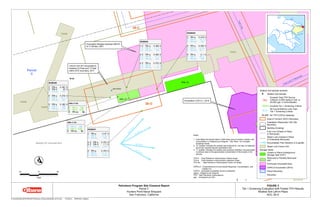
G:Arc GISNavyHPSPRO JECTSParc e l_ CClos ure Soil28O _ 2014.m xd 3/13/2015 JPARTSCH,Gilbane
FIGURE 3
Tie r 1Sc re e ning Evaluation with Pos te d TPHRe s ults
ShallowSoilLe ft-in-Plac e
AO C28-O
Petroleum Program Site Closeout Report
Parc e lC
Hunte rs PointNavalShipyard
San Franc is c o,California
10 0 10
Fe e t
"!O
ShallowSoilSam ple Sym bols
! ShallowSoilSam ple
RED
Exc e e d s TotalTPHSourc e
Crite rion (3,500m g/kg in Soil,or
20,000μg/Lin Ground wate r)
GREEN Exc e e d s Tie r 1Sc re e ning Crite ria
BLUE
AllConc e ntrations Le s s Than
Tie r 1Sc re e ning Crite ria
BLACK No TPHCO PCs De te c te d
Are aof Conc e rn (AO C)Bound ary
Ins tallation Re s toration (IR)Site
Bound ary
Build ing (Exis ting)
Fue lLine (Clos e d -in-Plac e
or Re m ove d )
Ste am Line (Clos e d -in-Plac e
or Pote ntiallyRe m ove d )
G
Ground wate r FlowDire c tion in A-aquife r
Se we r Line Tre nc h Unit
Storage Tanks
Clos e d -In-Plac e Und e rground
Storage Tank (UST)
Re m ove d or PartiallyRe m ove d
UST
Pre vious lyExc avate d Are a
CERCLAExc avation (2014)
Parc e lBound ary
Shore line
Note s :
1.Ins e ttable s lis ts am ple d e pth in fe e tbe lowground s urfac e ,analyte ,and
c onc e ntration in m illigram s pe r kilogram .Se e Table 1for c om ple te
analytic alre s ults .
2."U"qualifie r ind ic ate s the analyte was analyze d for,butwas notd e te c te d
above the re porte d s am ple quantitation lim it.
3."J"qualifie r ind ic ate s the analyte was pos itive lyid e ntifie d ;the as s oc iate d
num e ric alvalue is the approxim ate c onc e ntration of the analyte in the
s am ple .
TPH-d -TotalPe trole um Hyd roc arbons (d ie s e lrange )
TPH-g -TotalPe trole um Hyd roc arbons (gas oline range )
TPH-m o -TotalPe trole um Hyd roc arbons (m otor oilrange )
CERCLA-Com pre he ns ive Environm e ntalRe s pons e ,Com pe ns ation,and
LiabilityAc t
CO PCs -c he m ic als of pote ntialc onc e rn (analyze d )
m g/kg -m illigram s pe r kilogram
TPH-TotalPe trole um Hyd roc arbons
μg/L-m ic rogram s pe r lite r
Exc avation M e rge d Subare a280101
to 11.68fe e t,2001
Exc avation CO S-2-1,2014
Tre nc h Unit221e xc avate d to
be twe e n 6.5fe e tand 7.0fe e t
within AO Cbound ary,2011
2. !!!!
!!
!
!!
!
!!!!!!!!!!!!!!!!!!!!!!!!!!!!!!!!!
!
!!!
!
!
!
!
!
!
!!!!!!!!!!!!!!!!!!!!
!!
!
!
!
!!!
!!
!!
!!
!!!!!!!!!
!
!!!
!
!!
!
!!!
!
!
!
!
!!
!
!!!!!!!!!!!!!!!!!!!!!!!
!
!!!!!
!
!!
!!
!!
!!
!
!
!
!
!
!
!!
!
!
!!
!
!
!
!!
!
!!!!
!
!!!
!
!!!!!!!!!!!!!!!!!!!!!!!!!!!!!!!!!!!!!!!
!!!!!!!!!!
!!
!
!
!
!
!!!!!!!!!!!!!
!
!!
!
!
!
!
!
!
!!!!!!
!
!!!!!!!!!!!!
!!!!
!
!!
!!!!!
!
!
!
!!!!!!!!!!
!
!!!!
!
!
IR28MW271A 1995
————————————————————
1' TTPH 11000
1' TPH-g 0.39J
1' TPH-d 630
1' TPH-mo10000
1' BZAP 0.35U
6.5' TPH-g 0.61U
6.5' TPH-d 12U
6.5' TPH-mo 8.4J
6.5' BZAP 0.4U
11.5'TPH-g 0.58U
11.5'TPH-d 12U
11.5'TPH-mo 12U
11.5'BZAP 0.38U
16.5'TPH-g 0.63U
16.5'TPH-d 13U
16.5'TPH-mo 13U
16.5'BZAP 0.41U
21.5'TPH-g 0.6U
21.5'TPH-d 12U
21.5'TPH-mo 12U
21.5'BZAP 0.4U
IR49TA22 (B) 1994
—————————————————
7'TTPH 5400
7'TPH-g 0.57U
7'TPH-d 3700
7'TPH-mo 1700
7'BZAP 0.38U
IR49GB22C 2001
———————————————————
0.5'TPH-g 0.31U
0.5'TPH-d 420
0.5'TPH-mo 1500
0.5'BZAP NA
2.5'TPH-g 0.29U
2.5'TPH-d 1.1U
2.5'TPH-mo 5.6U
2.5'BZAP NA
IR49TA22 (9916Z001) 1999
——————————————————————
7.5'TPH-g 0.6U
7.5'TPH-d 43
7.5'TPH-mo 300
7.5'BZAP NA
IR28GB271C 2001
—————————————————
1'TPH-g 0.33U
1'TPH-d 6.5
1'TPH-mo 34
1'BZAP NA
3'TPH-g 0.3U
3'TPH-d 1.9
3'TPH-mo 8.2
3'BZAP NA
IR49TA22 (A) 1994
————————————————
7'TPH-g 0.6U
7'TPH-d 1600
7'TPH-mo 690
7'BZAP 0.081J
IR49TA22 (C) 1994
—————————————————
7'TPH-g 0.66U
7'TPH-d 1600
7'TPH-mo 900
7'BZAP 0.44U
FuelLine8"Removed
49-C
IR28MW271A
IR49TA22
Gro un dwa terResultsin
m icro gra m sperliterfo r
IR28MW271A
Date TTPH
————————————————
(05/03/1996)ND
(02/28/1996)ND
(11/09/1995)66
Gro un dwa terResultsin
m icro gra m sperliterfo r
IR49B032
Date TTPH
———————————————
(08/06/2014)ND
IR49B032 2014
——————————————————
5'TPH-g 0.09U
5'TPH-d 50J
5'TPH-mo 308
5'BZAP 0.0103J
8'TPH-g 0.09U
8'TPH-d 1.1J
8'TPH-mo 7.98
8'BZAP 0.0012J
IR49B033 2014
——————————————————
5'TPH-g 0.1U
5'TPH-d 45.9
5'TPH-mo 115
5'BZAP 0.0033J
8'TPH-g 0.301
8'TPH-d 123
8'TPH-mo 187
8'BZAP 0.0111
IR49B034 2014
——————————————————
5'TPH-g 0.12U
5'TPH-d 3.6U
5'TPH-mo 7.2U
5'BZAP 0.0036U
8'TPH-g 0.09U
8'TPH-d 4.04
8'TPH-mo 4.2J
8'BZAP 0.0038U
Berth2
Parcel
C
TU325
IR-28
G:ArcGISNa vyHPSPRO JECTSPa rcel_ CClo sureSo il49C_ 271A_ TA22_ deta il.m xd 1/9/2015 [11:21AM ] JPARTSCH,ITSIGilb a n e
FIGURE 7
Tier1Screen in g Eva lua tio n
Sha llo w So ilLeft-in -Pla ce with Po sted TPHa n d PAHResults
AO C49-C,Deta ilo fBo rin gsa tSitesBO CIR28M W 271A
a n d BO CIR49TA22
Petroleum Program Site Closeout Report
Pa rcelC
Hun tersPo in tNa va lShipya rd
Sa n Fra n cisco ,Ca lifo rn ia
10 0 10
Feet
"!O
Sha llo w So ilSa m ple Sym b o ls
! Sha llo w So ilSa m ple
RED
ExceedsTo ta lTPHSo urce
Criterio n (3,500m g/kg in So il,o r
20,000μg/Lin Gro un dwa ter)
GREEN ExceedsTier1Screen in g Criteria
BLUE
AllCo n cen tra tio n sLessTha n
Tier1Screen in g Criteria
BLACK No TPHCO PCsDetected
Area o fCo n cern (AO C)Bo un da ry
In sta lla tio n Resto ra tio n (IR)Site
Bo un da ry
Ra ils
Ro a d/Curb
FuelLin e (Clo sed-in -Pla ce
o rRem o ved)
Stea m Lin e (Clo sed-in -Pla ce
o rPo ten tia llyRem o ved)
Ra dio lo gica lSurveyUn it
Pa rcelBo un da ry
Sho relin e
No tes:
1.In setta b le listssa m ple depth in feetb elo w gro un d surfa ce,a n a lyte,a n d
co n cen tra tio n in m illigra m sperkilo gra m .See Ta b le 1fo rco m plete
a n a lytica lresults.
2."U"qua lifierin dica testhe a n a lyte wa sa n a lyzed fo r,b utwa sn o tdetected
a b o ve the repo rted sa m ple qua n tita tio n lim it.
3."J"qua lifierin dica testhe a n a lyte wa spo sitivelyiden tified;the a sso cia ted
n um erica lva lue isthe a ppro xim a te co n cen tra tio n o fthe a n a lyte in the
sa m ple.
PAH -Po lycyclic Aro m a tic Hydro ca rb o n
BZ AP-Ben zo (a )pyren e
TPH -To ta lPetro leum Hydro ca rb o n s
TPH-d -To ta lPetro leum Hydro ca rb o n s(dieselra n ge)
TPH-g -To ta lPetro leum Hydro ca rb o n s(ga so lin e ra n ge)
TPH-m o -To ta lPetro leum Hydro ca rb o n s(m o to ro ilra n ge)
TTPH -To ta lTPH(to ta lo fa llhydro ca rb o n fra ctio n sa n a lyzed)
NA-No tAn a lyzed in sa m ple
ND-No tDetected in sa m ple
CO PCs-chem ica lso fpo ten tia lco n cern (a n a lyzed)
m g/kg -m illigra m sperkilo gra m
μg/L-m icro gra m sperliter
3. G:ArcGISNavyHPSPROJECTSParcel_CClosurepC_GW_Qtr2_2013_wDivide.mxd 6/24/2014 [19:11 PM] JPARTSCH, Gilbane
FIGURE 6
Groundwater Potentiometric Surface Map, A-aquifer
Quarter 2, 2013
Petroleum Program Site Closeout Report
Parcel C
Hunters Point Naval Shipyard
San Francisco, California
G
G
G
G
G
G
G
G
G
!ÒA
!ÒA
!ÒA
!ÒA
!ÒA !ÒA
!ÒA
!ÒA
!ÒA
!ÒA
!ÒA
!ÒA
!ÒA
!ÒA
!ÒA
!ÒA
!ÒA
!ÒA
!ÒA
!ÒA
!ÒA
!ÒA
!ÒA
!ÒA
!ÒA
!ÒA
!ÒA
!ÒA
!ÒA
!ÒA
!ÒA
!ÒA
!ÒA
!ÒA
!ÒA
!ÒA
!ÒA
!ÒA
!ÒA
!ÒA !ÒA
!ÒA
!ÒA
!ÒA
!ÒA
!ÒA
!ÒA
!ÒA
!ÒA
!ÒA
!ÒA
!ÒA
!ÒA
!ÒA
!ÒA
!ÒA
!ÒA
!ÒA
!ÒA
!ÒA
!ÒA !ÒA
!ÒA
!ÒA
!ÒA
!ÒA
!ÒA
!ÒA
!ÒA
!ÒA
!ÒA
!ÒA
!ÒA
!ÒA
!ÒA
!ÒA
!ÒA
San Francisco Bay
49-C
49-C
49-C
49-C
49-C
Islais ValleyGroundwaterBasin
South San Francisco
GroundwaterBasin
Spear Ave. (Asphalt)
Lockwood
St. (Asphalt)
FischerAve.(Asphalt)
Nimitz Ave. (Asphalt)
MorrellSt.(Asphalt)
Horne
Ave.(Asphalt)
Blandy
St. (Asphalt)
Galvez Ave. (Asphalt)
CochraneSt.(Asphalt)
Robinson St. (Asphalt)
E
Street (Asphalt)
HillDr.(Asphalt)
Van Keuren Ave. (Asphalt)
CStreet(Asphalt)
Spear Ave. (Asphalt)
Hill Dr. (A
sphalt)
DRY
DOCK
4
DRY DOCK 3
DRY DOCK 2
Berth 4
Berth 3
Berth2
Berth 9
Berth 8
Berth 6
Berth1
Berth5 Berth 7
Berth
10
Parcel
C
411
231
101
211
253
281
123
134
228
251
258
366
217
272
302
402
113
363
203
901
241
351A
116
205
369
282
921
415
252
275
368
351
225
230
110
324
206
140
214
120
115
104
271
102
I
215
303
113A
372
208
156
301
207
323
274
219
109
103
Z
813
367
135
224
418
364407
154
304
420
H
226
308
229
238
424
280
204
218
300
R-26
417
235
R-14
419
130
422
R-97
421
1
4
5
2
3
6
-1
2
3
6
CAA-1
CAA-3
CAA-2
CAA-14
CAA-13
28-J
49-A
06-A
28-B
30-A
28-H
30-B
57-A
49-B
28-N
46C-A
28-A
28-K
45C-A
49-E
IR22B022
29-C
29-B
27-A
28-P
25-A
49-D
28-E
28-F
28-Q
28-M58-B
28-D
28-G
28-I
58-A
28-O
IR28B257
IR29B040
28-L
IR28MW271A
IR49TA22
IR28MW297A
IR28MW294A
28-C
PA58SS01
300 0 300
Feet
"!O Note: Groundwater potentiometric surface map based on
depth-to-water information provided by CE2-Kleinfelder.
* Groundwater Basin Divide from California Department
of Water Resources, Integrated Water Resources
Information System (http://app1.iwris.water.ca.gov/iwris/)
!ÒA
Monitoring Well Location
(Quarter 2, 2013)
G
Groundwater Flow Direction in A-aquifer
Groundwater Basin Divide*
Groundwater Elevation Contour
(in Feet Above Mean Sea Level)
Area of Concern (AOC) Boundary
Corrective Action Area (CAA) Boundary
Building (Existing)
Parcel C Boundary
Shoreline
Road/Curb
Rails
4. G:ArcGISNavyHPSPROJECTSParcel_CSSWPSampLocs46C-A_alt_GW.mxd 6/12/2013 [16:57 PM] JPARTSCH, ITSI
FIGURE 19
Estimated Distribution of Maximum Total TPH in Groundwater,
August 2000 to January 2001
AOC 46C-A
Petroleum Hydrocarbon Project Work Plan
Parcel C
Hunters Point Naval Shipyard
San Francisco, California
G
G
G
ÒA
ÒA
ÒA
ÒA
ÒA
ÒA
ÒA
ÒA
ÒA
ÒA
ÒA
ÒA
ÒA
ÒA
ÒA
ÒA
ÒA
ÒA
ÒA
ÒA
ÒA
ÒA
ÒA
ÒA
ÒA
ÒA
ÒA
ÒA
ÒA
ÒA
ÒA
ÒA
ÒA
ÒA
ÒA
********************
Q12011
Q12011
Q1 2011
IR25MW56A
IR25MW55A
IR25MW42B
IR25MW39A
IR25MW22A
(TTPH = 79,000 μg/L)
IR25MW51A
IR25MW38B
IR25MW20A
IR25MW19A
(TTPH = 210,000 μg/L)
IR25MW18A
(TTPH = 15,000 μg/L)
IR25MW17A
IR25MW15F
IR06MW41A
(TTPH = 200 μg/L)
IR06MW32A
IR25MW53A
IR25MW52A
IR25MW40A
IR25MW39B
IR25MW11A
(TTPH = 55,000 μg/L)
IR25MW57A
IR25MW54A
IR06MW47F
IR06MW44A
(TTPH = 1,900 μg/L)
IR06MW40A
IR25MW903B
IR25MW902B
IR25MW60A2
IR25MW60A1
IR25MW905B
IR25MW900B
IR06MW32AD
IR25MW904B
IR25MW901B
IR25MW15A2
IR25MW15A1
(TTPH = 47,000 μg/L)
1,000
10,000
100,000
25-A
46C-A
06-A
Building 134 (concrete floor)
Building
(concrete floor)
Building 123 (concrete floor) Building 156
(concrete floor)
Lockwood
St. (Asphalt)
TU312 (depth
unknown)
TU54 (depth
unknown)
TU16(depth
unknown)
TU17 (13.9 ft)
TU56(depth
unknown)
TU29(8.9ft)
TU6 (4.1 ft)TU18 (6.7 ft)
TU7
(3.9 ft)
TU313 (depth
unknown) TU314
(depth
unkn
TU5 (6.0 ft)
TU15
(6.9 ft)
TU6
(4.1 ft)
Excavation 10-3 (8.5 ft)Excavation 10-3 (8.5 ft)
Excavation 10-3 (8.5 ft)
Excavation 10-3 (8.5 ft)
Excavation 11-2 (7.5 ft)
Excavation 11-2 (7.5 ft)
A-1
B-2
20-1
B-4
Fuel Line D1
B3822
24-7
B-1
A-3
B3625
B3425
6-1
24-6
6-6
B3622
B-5
Fuel Lines
A and B
Fuel Line A
Fuel Line C
B-9
B3921
Fuel Line D2
Subarea 250201
A-2
B-7
3927
Parcel
C
124
IR-25
IR-24
IR-20
IR-06
IR-10
IR-42
!! Proposed Soil Boring
Proposed Grab GW Sample
!(A Proposed Well
***** Grab Groundwater Sample
ÒA Monitoring Well Sample
Area of Concern (AOC) Boundary
Building (Existing)
Building 134 Interior Walls
Building (Demolished)
Planned CERCLA Excavation
Previously Excavated Area
IR Site Boundary
Parcel Boundary
Shoreline
Radiological Survey Unit
G
Groundwater Flow Direction in A-aquifer
Road/Curb
Rails
Steam Line (Closed-in-Place
or Potentially Removed)
Steam Line (Removed)
Isoconcentration Contour:
Total TPH in μg/L in Groundwater
Interpolated
Inferred
Former Degreaser
Former Separator
40 0 40
Feet
"!O Notes:
1. For soil samples exceeding source criterion value, location ID and
Total TPH concentration (in micrograms per liter) are shown in red.
2. Map symbols and site features that appear in the legend may not
appear on all figures.
TTPH - Total Petroleum Hydrocarbons (Total of Gas, Diesel, and Motor Oil)
Name Depth (feet)
20-1 3.0
24-6 6.0
24-7 uncertain
3927 uncertain
6-1 uncertain
6-6 uncertain
A-1 9.0
A-2 uncertain
A-3 uncertain
B-1 uncertain
B-2 uncertain
B3425 6.0
B3622 10.0
B3625 10.0
B3822 uncertain
B3921 uncertain
B-4 uncertain
B-5 uncertain
B-7 uncertain
B-9 uncertain
Fuel Line A uncertain
Fuel Line C 6.0
Fuel Line D1 uncertain
Fuel Line D2 uncertain
Fuel Lines A and B 4.0
Subarea 250201 3.88
Previously Excavated Areas
5. ?
? ?
?
ÒA
ÒA
ÒA
ÒA ÒA
ÒA
ÒA
ÒA
ÒA
!
!
!
!
!
!
!
!
!!
!
!!
!!
!
!
!
!
!
!
!
!
!
!
!
!
!
!
!
!
!
!!
!!!
!
!
!
!
!!
!
!
!
!
!
!
!
!
!
!
!!
!!
!!
!
!
!
!
!
!
!
!!
!
!
!
!
!
!
!!
!!
!
!
!
!
!
!!
!!
!
!
!
!!!!!
!
!!
!!
!
!
!
!
14
12
10
6
4
-2 0
46
8
2
8
IR06B018
IR06B004
IR06B003
IR06B028A
IR06B021
IR06B039
IR06B033
IR06B028
IR06B026
IR06B025
IR06B024
IR06B020
IR06B019
IR06B017
IR06B016
IR06B015
IR06B014
IR06B013
IR06B012
IR06B011
IR06B010
IR06B009
IR06B008
IR06B007
IR06B006
IR06B005
IR06B002
IR06B001
IR06MW22A
IR06MW34A
IR06MW50F
IR06MW32A
IR06MW49F
IR06MW30A
IR06MW51F
IR06MW27A
IR06MW23A
2
0
4
6
8
-2
10
12
14
6
8
0
-2
4
Building 134 (concrete floor)
Building (concrete floor)
06-A
46C-A
25-A
Robinson St. (Asphalt)
Lockwood
St. (Asphalt)
Excavation 10-3 (8.5 ft*)
Excavation 10-4
(9 ft)
Excavation 10-3
(8.5 ft*)
Excavation 10-3
(8.5 ft*)
Excavation 10-3
(8.5 ft*)
Excavation 10-5
(7 ft)
TU313
(depth unknown)
TU314
(depth unknown)
TU312
(depth unknown)
TU5 (6.0 ft)
TU26
(4.5 ft)
TU136 (7.1 ft)
TU15 (6.9 ft)
10
5 3
8 46
9
7
2
1
A-1
B-2
B-4
B-1
Fuel Lines A and B
A-3
6-3
6-1
B-9
6-6
4227
B-5
A-2
Subarea 250201
B-7
3927
Parcel
C
112
111
IR-06
IR-25
IR-42
IR-24
30 0 30
Feet
ÒA Existing Monitoring Well (MW)
ÒA Abandoned or Removed MW
! Shallow Soil Sample; Left-in-Place
Deep Soil Sample; Left-in-Place
! Shallow Soil Sample; Removed
Deep Soil Sample; Removed
Inferred Bedrock Surface Elevation
Contour (ft. above mean sea level)
Estimated Historical Distribution
of (mobile) LNAPL in 1990 based
on descriptive logs for RI borings
and monitoring wells
Area of Concern (AOC) Boundary
Building (Existing)
Building (Demolished)
Planned CERCLA Excavation
Previously Excavated Area
IR Site Boundary
Parcel Boundary
Shoreline
Radiological Survey Unit
Road/Curb
Rails
Steam Line (Closed-in-Place
or Potentially Removed)
Steam Line (Removed)
Storage Tanks
Removed Abvoveground Storage
Tank (AST)
Closed-In-Place Underground
Storage Tank (UST)
Removed or Partially Removed
UST
G:ArcGISNavyHPSPROJECTSParcel_CSSWPBedrockContours06-A.mxd 6/12/2013 [16:46 PM] JPARTSCH, ITSI
FIGURE 7
Subsurface Topography of Serpentine Bedrock
AOC 06-A
Petroleum Hydrocarbon Project Work Plan
Parcel C
Hunters Point Naval Shipyard
San Francisco, California
"!O Notes:
1. Bedrock contours are based upon elevation of ground surface minus
depth of bedrock contact as reported on remedial investigation boring
logs. The datum used for ground surface elevation is unknown.
2. Map symbols and site features that appear in the legend may not
appear on all figures.
* Excavation 10-3 planned to 4 ft depth in some areas.
Name Depth (feet)
3927 uncertain
4227 uncertain
6-1 uncertain
6-3 uncertain
6-6 uncertain
A-1 9.0
A-2 uncertain
A-3 uncertain
B-1 uncertain
B-2 uncertain
B-4 uncertain
B-5 uncertain
B-7 uncertain
B-9 uncertain
Fuel Lines A and B 4.0
Subarea 250201 3.88
Previously Excavated Areas
6. Stream Channel Widths in the Ohio
River and Tributaries Above
Warsaw, Kentucky, Using the
RivWidth* Algorithm
Figure 1-4
* Raster data from the United States Geological Survey 2001 National Land Cover Dataset (NLCD 2001) was processed using the RivWidth
algorithm developed by Tamlin Pavelsky and Laurence Smith (2008) to obtain stream width values and stream centerline locations for streams
within the Ohio River Basin.
Pavelsky, T. M., and L. C. Smith. 2008. RivWidth: A Software Tool for the Calculation of River Widths From Remotely Sensed Imagery. IEEE Geoscience and Remote
Sensing Letters, Vol. 5, No. 1, January 2008, pp 70-73.
Jonathan Partsch, May 2008
![!!!!
!!
!
!!
!
!!!!!!!!!!!!!!!!!!!!!!!!!!!!!!!!!
!
!!!
!
!
!
!
!
!
!!!!!!!!!!!!!!!!!!!!
!!
!
!
!
!!!
!!
!!
!!
!!!!!!!!!
!
!!!
!
!!
!
!!!
!
!
!
!
!!
!
!!!!!!!!!!!!!!!!!!!!!!!
!
!!!!!
!
!!
!!
!!
!!
!
!
!
!
!
!
!!
!
!
!!
!
!
!
!!
!
!!!!
!
!!!
!
!!!!!!!!!!!!!!!!!!!!!!!!!!!!!!!!!!!!!!!
!!!!!!!!!!
!!
!
!
!
!
!!!!!!!!!!!!!
!
!!
!
!
!
!
!
!
!!!!!!
!
!!!!!!!!!!!!
!!!!
!
!!
!!!!!
!
!
!
!!!!!!!!!!
!
!!!!
!
!
IR28MW271A 1995
————————————————————
1' TTPH 11000
1' TPH-g 0.39J
1' TPH-d 630
1' TPH-mo10000
1' BZAP 0.35U
6.5' TPH-g 0.61U
6.5' TPH-d 12U
6.5' TPH-mo 8.4J
6.5' BZAP 0.4U
11.5'TPH-g 0.58U
11.5'TPH-d 12U
11.5'TPH-mo 12U
11.5'BZAP 0.38U
16.5'TPH-g 0.63U
16.5'TPH-d 13U
16.5'TPH-mo 13U
16.5'BZAP 0.41U
21.5'TPH-g 0.6U
21.5'TPH-d 12U
21.5'TPH-mo 12U
21.5'BZAP 0.4U
IR49TA22 (B) 1994
—————————————————
7'TTPH 5400
7'TPH-g 0.57U
7'TPH-d 3700
7'TPH-mo 1700
7'BZAP 0.38U
IR49GB22C 2001
———————————————————
0.5'TPH-g 0.31U
0.5'TPH-d 420
0.5'TPH-mo 1500
0.5'BZAP NA
2.5'TPH-g 0.29U
2.5'TPH-d 1.1U
2.5'TPH-mo 5.6U
2.5'BZAP NA
IR49TA22 (9916Z001) 1999
——————————————————————
7.5'TPH-g 0.6U
7.5'TPH-d 43
7.5'TPH-mo 300
7.5'BZAP NA
IR28GB271C 2001
—————————————————
1'TPH-g 0.33U
1'TPH-d 6.5
1'TPH-mo 34
1'BZAP NA
3'TPH-g 0.3U
3'TPH-d 1.9
3'TPH-mo 8.2
3'BZAP NA
IR49TA22 (A) 1994
————————————————
7'TPH-g 0.6U
7'TPH-d 1600
7'TPH-mo 690
7'BZAP 0.081J
IR49TA22 (C) 1994
—————————————————
7'TPH-g 0.66U
7'TPH-d 1600
7'TPH-mo 900
7'BZAP 0.44U
FuelLine8"Removed
49-C
IR28MW271A
IR49TA22
Gro un dwa terResultsin
m icro gra m sperliterfo r
IR28MW271A
Date TTPH
————————————————
(05/03/1996)ND
(02/28/1996)ND
(11/09/1995)66
Gro un dwa terResultsin
m icro gra m sperliterfo r
IR49B032
Date TTPH
———————————————
(08/06/2014)ND
IR49B032 2014
——————————————————
5'TPH-g 0.09U
5'TPH-d 50J
5'TPH-mo 308
5'BZAP 0.0103J
8'TPH-g 0.09U
8'TPH-d 1.1J
8'TPH-mo 7.98
8'BZAP 0.0012J
IR49B033 2014
——————————————————
5'TPH-g 0.1U
5'TPH-d 45.9
5'TPH-mo 115
5'BZAP 0.0033J
8'TPH-g 0.301
8'TPH-d 123
8'TPH-mo 187
8'BZAP 0.0111
IR49B034 2014
——————————————————
5'TPH-g 0.12U
5'TPH-d 3.6U
5'TPH-mo 7.2U
5'BZAP 0.0036U
8'TPH-g 0.09U
8'TPH-d 4.04
8'TPH-mo 4.2J
8'BZAP 0.0038U
Berth2
Parcel
C
TU325
IR-28
G:ArcGISNa vyHPSPRO JECTSPa rcel_ CClo sureSo il49C_ 271A_ TA22_ deta il.m xd 1/9/2015 [11:21AM ] JPARTSCH,ITSIGilb a n e
FIGURE 7
Tier1Screen in g Eva lua tio n
Sha llo w So ilLeft-in -Pla ce with Po sted TPHa n d PAHResults
AO C49-C,Deta ilo fBo rin gsa tSitesBO CIR28M W 271A
a n d BO CIR49TA22
Petroleum Program Site Closeout Report
Pa rcelC
Hun tersPo in tNa va lShipya rd
Sa n Fra n cisco ,Ca lifo rn ia
10 0 10
Feet
"!O
Sha llo w So ilSa m ple Sym b o ls
! Sha llo w So ilSa m ple
RED
ExceedsTo ta lTPHSo urce
Criterio n (3,500m g/kg in So il,o r
20,000μg/Lin Gro un dwa ter)
GREEN ExceedsTier1Screen in g Criteria
BLUE
AllCo n cen tra tio n sLessTha n
Tier1Screen in g Criteria
BLACK No TPHCO PCsDetected
Area o fCo n cern (AO C)Bo un da ry
In sta lla tio n Resto ra tio n (IR)Site
Bo un da ry
Ra ils
Ro a d/Curb
FuelLin e (Clo sed-in -Pla ce
o rRem o ved)
Stea m Lin e (Clo sed-in -Pla ce
o rPo ten tia llyRem o ved)
Ra dio lo gica lSurveyUn it
Pa rcelBo un da ry
Sho relin e
No tes:
1.In setta b le listssa m ple depth in feetb elo w gro un d surfa ce,a n a lyte,a n d
co n cen tra tio n in m illigra m sperkilo gra m .See Ta b le 1fo rco m plete
a n a lytica lresults.
2."U"qua lifierin dica testhe a n a lyte wa sa n a lyzed fo r,b utwa sn o tdetected
a b o ve the repo rted sa m ple qua n tita tio n lim it.
3."J"qua lifierin dica testhe a n a lyte wa spo sitivelyiden tified;the a sso cia ted
n um erica lva lue isthe a ppro xim a te co n cen tra tio n o fthe a n a lyte in the
sa m ple.
PAH -Po lycyclic Aro m a tic Hydro ca rb o n
BZ AP-Ben zo (a )pyren e
TPH -To ta lPetro leum Hydro ca rb o n s
TPH-d -To ta lPetro leum Hydro ca rb o n s(dieselra n ge)
TPH-g -To ta lPetro leum Hydro ca rb o n s(ga so lin e ra n ge)
TPH-m o -To ta lPetro leum Hydro ca rb o n s(m o to ro ilra n ge)
TTPH -To ta lTPH(to ta lo fa llhydro ca rb o n fra ctio n sa n a lyzed)
NA-No tAn a lyzed in sa m ple
ND-No tDetected in sa m ple
CO PCs-chem ica lso fpo ten tia lco n cern (a n a lyzed)
m g/kg -m illigra m sperkilo gra m
μg/L-m icro gra m sperliter](data:image/gif;base64,R0lGODlhAQABAIAAAAAAAP///yH5BAEAAAAALAAAAAABAAEAAAIBRAA7)