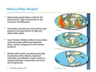
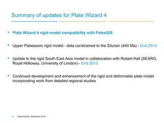
Plate Wizard updates
within the latest
release of PaleoGIS
John Watson

14-11-2013
Project Rationale
What is Plate Wizard?

2

Plate Wizard | Robertson 2013
What is Plate Wizard?
 Deformable global plate model for the
Phanerozoic, data constrained for the
Cenozoic and Mesozoic
 Accurately reconstructs and predicts past
positions and geometries of rigid and
deformable plates
 User friendly ArcMap toolbar to accurately
reconstruct geo-referenced datasets
(lines, points, polygons) to their palaeolocations
 Models deformation at extensional plate
boundaries of the Atlantic, Southern
Australian and Western Indian Ocean to
restore extended continental crust to its
pre-rift geometry
3

Plate Wizard | Robertson 2013
Rigid and Deformable Plate Model
Plate boundary definitions
Plate model rotation

4

Plate Wizard | Robertson 2013
Plate boundary definitions – geological and geophysical data

Structural datasets

FAG (mGal)
5

Fieldwork

Crustal thickness (m)

Plate Wizard | Robertson 2013

Palaeogeographic mapping

Magnetic Anomaly (nT)
Plate model rotation – Hybrid model for Plate Wizard 4

Plate Wizard 2 and 3
 Fixed Hotspot reference frame – 0 to 250 Ma

Plate Wizard 3

Plate Wizard 4 (Release date: end 2013)
 Fixed Hotspot reference frame – 0 to 120 Ma
 Palaeo-mag reference frame – 120 to 440 Ma

Plate Wizard 4
6

Plate Wizard | Robertson 2013
Plate Wizard in Application
Indian Ocean deformable model
Reconstructing data with Plate Wizard
Plate Wizard as a base for Palaeogeographic Mapping – Merlin+

7

Plate Wizard | Robertson 2013
Indian Ocean deformable model – 250 Ma




S LR
LE

ca
r
M
ad
ag
as

India
M

EB
R



Saya de Malha
in-between
Madagascar and
India (based on
Yatheesh et al,
2006)

SM

PG

Mozambique

Seychelles and
Laxmi Ridge
joined to
northeast India
and East Africa

Ma

Tanzania
Mo

Madagascar
docked against
East Africa

SL
GR

East Antarctica

L

1:12,500,000 / WGS 1984
EB: Elan Bank / GR: Gunnerus Ridge / L: Lambert Rift / LE: Lamu Embayment / LR: Laxmi Ridge / M:
Mahanadi Rift / Ma: Majunga Basin / Mo: Morondava Basin / PG: Pranhita-Godavari Rift / R: Rovuma / S:
Seychelles / SL: Sri Lanka / SM: Saya de Malha
8

Plate Wizard | Robertson 2013
Indian Ocean deformable model – 170 Ma



LE
Tanzania

S LR
Ma

Mo

Mozambique
R

d
Ma

as
ag

ca

r

Madagascar and
Seychelles rift from
East Africa
Seafloor spreading
initiates at ~160Ma
and East Africa
based on Muller et
al, 2008 isochron
dataset

SM

India
PG

M
170Ma: Initial separation of AntarcticaAfrica relative to India-Madagascar during
SL
the Early to Mid Jurassic (based upon EB
GR
East Antarctica
reviews by Reeves & De Wit, 2000 and
1:12,500,000 / WGS 1984
Gaina et al, 2007).

EB: Elan Bank / GR: Gunnerus Ridge / L: Lambert Rift / LE: Lamu Embayment / LR: Laxmi Ridge / M:
Mahanadi Rift / Ma: Majunga Basin / Mo: Morondava Basin / PG: Pranhita-Godavari Rift / R: Rovuma / S:
Seychelles / SL: Sri Lanka / SM: Saya de Malha
9

Plate Wizard | Robertson 2013
Reconstructing data with Plate Wizard
North Atlantic deformable model with Tellus structural data (in grey) and sediment isopach
data (in red) reconstructed with the plate model
The data are intersected with the plate polygons and rotated to a chosen time slice with
the relevant plates
Extensional deformation
in Baffin Bay – Appended
and DEFORMABLY
MODELLED
Vs
Extensional deformation
in Labrador Sea Appended and RIGIDLY
MODELLED

Time slice – 84 Ma
Time slice – 0 Ma

10

Plate Wizard | Robertson 2013

Baffin Bay –
Data appended
and deformed

Labrador Sea –
Data not appended
and deformed
Plate Wizard as a base for Palaeogeographic Mapping

MERLIN+: Detailed Global Palaeogeography

Palaeo-Earth
systems
(climate and tides)

11

Plate Wizard | Robertson 2013
Summary of updates for Plate Wizard 4
 Plate Wizard 4 rigid model compatibility with PaleoGIS
 Upper Palaeozoic rigid model - data constrained to the Silurian (440 Ma) - End 2013
 Update to the rigid South East Asia model in collaboration with Robert Hall (SEARG,
Royal Holloway, University of London) - End 2013

 Continued development and enhancement of the rigid and deformable plate model
incorporating work from detailed regional studies

12

Plate Wizard | Robertson 2013

Plate Wizard Updates within PaleoGIS by John Watson, Robertson-CGG: 2013/Third Annual PaleoGIS & PaleoClimate Users Conference

  • 1.
    Plate Wizard updates withinthe latest release of PaleoGIS John Watson 14-11-2013
  • 2.
    Project Rationale What isPlate Wizard? 2 Plate Wizard | Robertson 2013
  • 3.
    What is PlateWizard?  Deformable global plate model for the Phanerozoic, data constrained for the Cenozoic and Mesozoic  Accurately reconstructs and predicts past positions and geometries of rigid and deformable plates  User friendly ArcMap toolbar to accurately reconstruct geo-referenced datasets (lines, points, polygons) to their palaeolocations  Models deformation at extensional plate boundaries of the Atlantic, Southern Australian and Western Indian Ocean to restore extended continental crust to its pre-rift geometry 3 Plate Wizard | Robertson 2013
  • 4.
    Rigid and DeformablePlate Model Plate boundary definitions Plate model rotation 4 Plate Wizard | Robertson 2013
  • 5.
    Plate boundary definitions– geological and geophysical data Structural datasets FAG (mGal) 5 Fieldwork Crustal thickness (m) Plate Wizard | Robertson 2013 Palaeogeographic mapping Magnetic Anomaly (nT)
  • 6.
    Plate model rotation– Hybrid model for Plate Wizard 4 Plate Wizard 2 and 3  Fixed Hotspot reference frame – 0 to 250 Ma Plate Wizard 3 Plate Wizard 4 (Release date: end 2013)  Fixed Hotspot reference frame – 0 to 120 Ma  Palaeo-mag reference frame – 120 to 440 Ma Plate Wizard 4 6 Plate Wizard | Robertson 2013
  • 7.
    Plate Wizard inApplication Indian Ocean deformable model Reconstructing data with Plate Wizard Plate Wizard as a base for Palaeogeographic Mapping – Merlin+ 7 Plate Wizard | Robertson 2013
  • 8.
    Indian Ocean deformablemodel – 250 Ma   S LR LE ca r M ad ag as India M EB R  Saya de Malha in-between Madagascar and India (based on Yatheesh et al, 2006) SM PG Mozambique Seychelles and Laxmi Ridge joined to northeast India and East Africa Ma Tanzania Mo Madagascar docked against East Africa SL GR East Antarctica L 1:12,500,000 / WGS 1984 EB: Elan Bank / GR: Gunnerus Ridge / L: Lambert Rift / LE: Lamu Embayment / LR: Laxmi Ridge / M: Mahanadi Rift / Ma: Majunga Basin / Mo: Morondava Basin / PG: Pranhita-Godavari Rift / R: Rovuma / S: Seychelles / SL: Sri Lanka / SM: Saya de Malha 8 Plate Wizard | Robertson 2013
  • 9.
    Indian Ocean deformablemodel – 170 Ma   LE Tanzania S LR Ma Mo Mozambique R d Ma as ag ca r Madagascar and Seychelles rift from East Africa Seafloor spreading initiates at ~160Ma and East Africa based on Muller et al, 2008 isochron dataset SM India PG M 170Ma: Initial separation of AntarcticaAfrica relative to India-Madagascar during SL the Early to Mid Jurassic (based upon EB GR East Antarctica reviews by Reeves & De Wit, 2000 and 1:12,500,000 / WGS 1984 Gaina et al, 2007). EB: Elan Bank / GR: Gunnerus Ridge / L: Lambert Rift / LE: Lamu Embayment / LR: Laxmi Ridge / M: Mahanadi Rift / Ma: Majunga Basin / Mo: Morondava Basin / PG: Pranhita-Godavari Rift / R: Rovuma / S: Seychelles / SL: Sri Lanka / SM: Saya de Malha 9 Plate Wizard | Robertson 2013
  • 10.
    Reconstructing data withPlate Wizard North Atlantic deformable model with Tellus structural data (in grey) and sediment isopach data (in red) reconstructed with the plate model The data are intersected with the plate polygons and rotated to a chosen time slice with the relevant plates Extensional deformation in Baffin Bay – Appended and DEFORMABLY MODELLED Vs Extensional deformation in Labrador Sea Appended and RIGIDLY MODELLED Time slice – 84 Ma Time slice – 0 Ma 10 Plate Wizard | Robertson 2013 Baffin Bay – Data appended and deformed Labrador Sea – Data not appended and deformed
  • 11.
    Plate Wizard asa base for Palaeogeographic Mapping MERLIN+: Detailed Global Palaeogeography Palaeo-Earth systems (climate and tides) 11 Plate Wizard | Robertson 2013
  • 12.
    Summary of updatesfor Plate Wizard 4  Plate Wizard 4 rigid model compatibility with PaleoGIS  Upper Palaeozoic rigid model - data constrained to the Silurian (440 Ma) - End 2013  Update to the rigid South East Asia model in collaboration with Robert Hall (SEARG, Royal Holloway, University of London) - End 2013  Continued development and enhancement of the rigid and deformable plate model incorporating work from detailed regional studies 12 Plate Wizard | Robertson 2013

Editor's Notes

  • #11 Example of a Tellus global structure data set in the Baffin Bay area at Present day - these data are intersected with the PWiz plate polygons so can be rotated to a chosen times slice/s with the relevant plate. To give you an example of how this works….You’re looking at the Baffin Bay region between Greenland and Northern Canada. Tellus structural elements and isopach data has been intersected with the global plate model in present day positions.