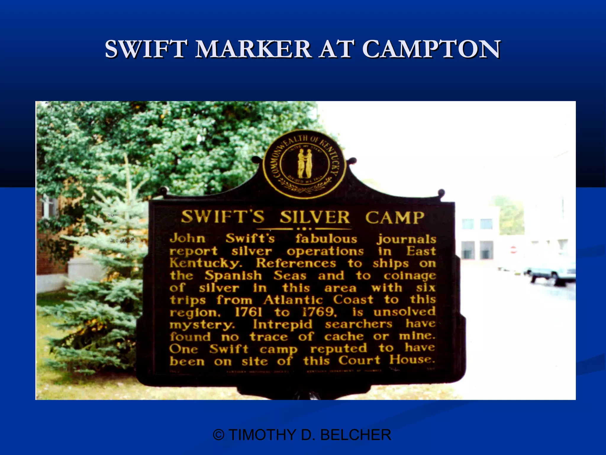
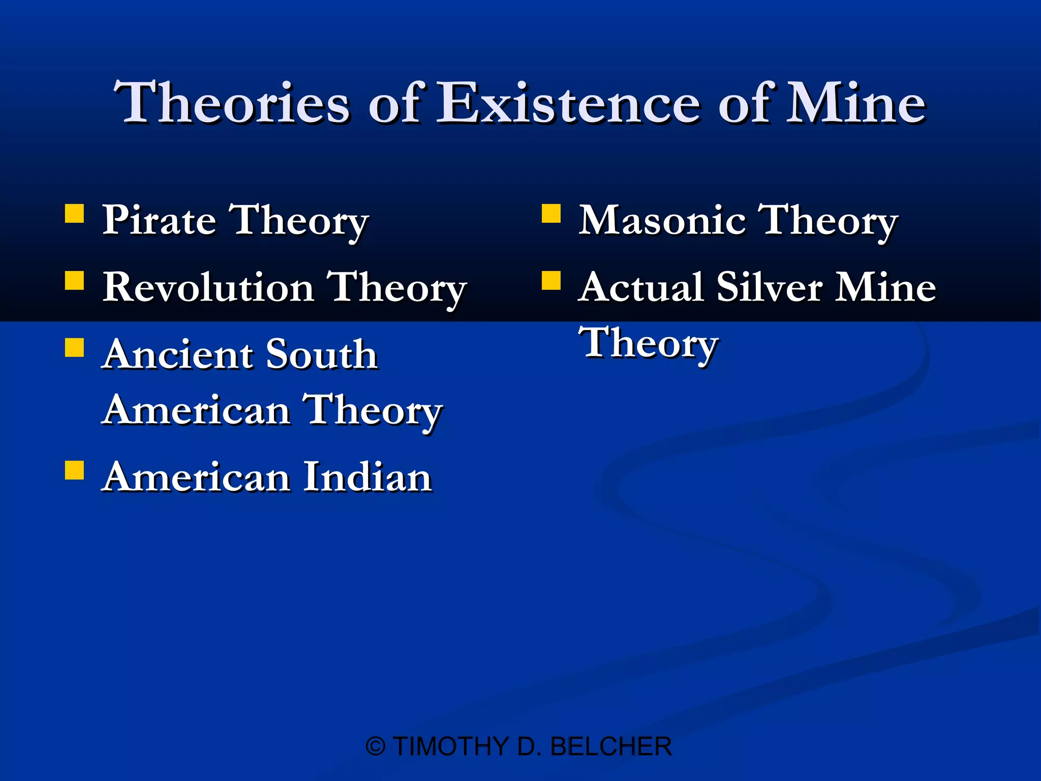
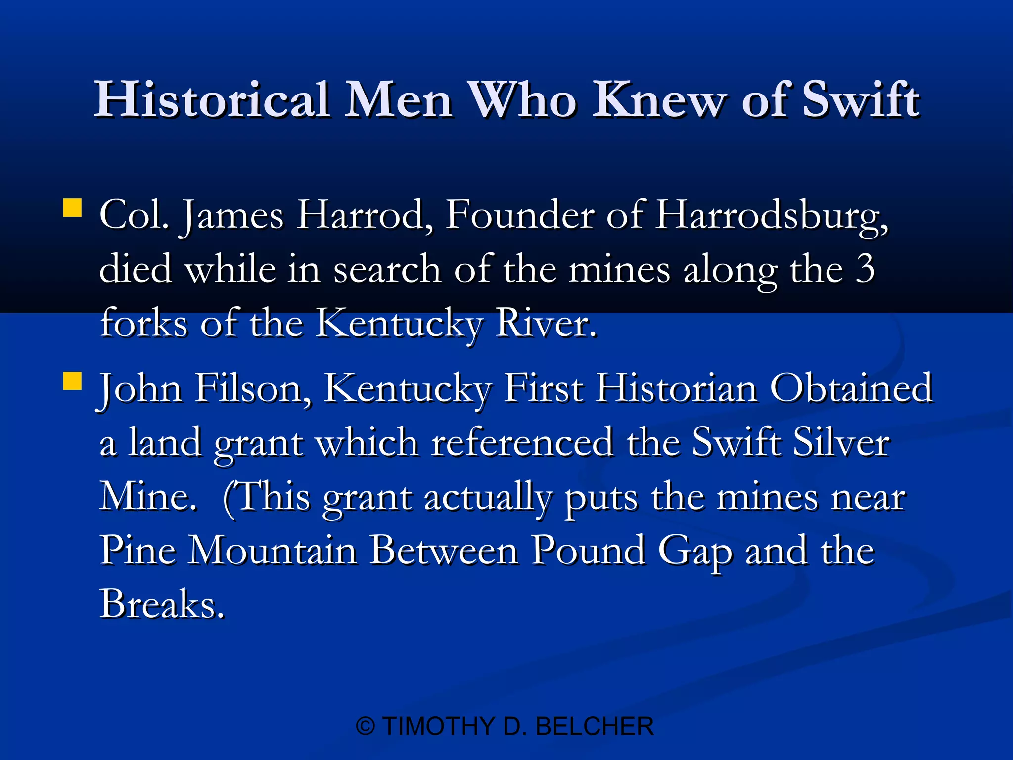
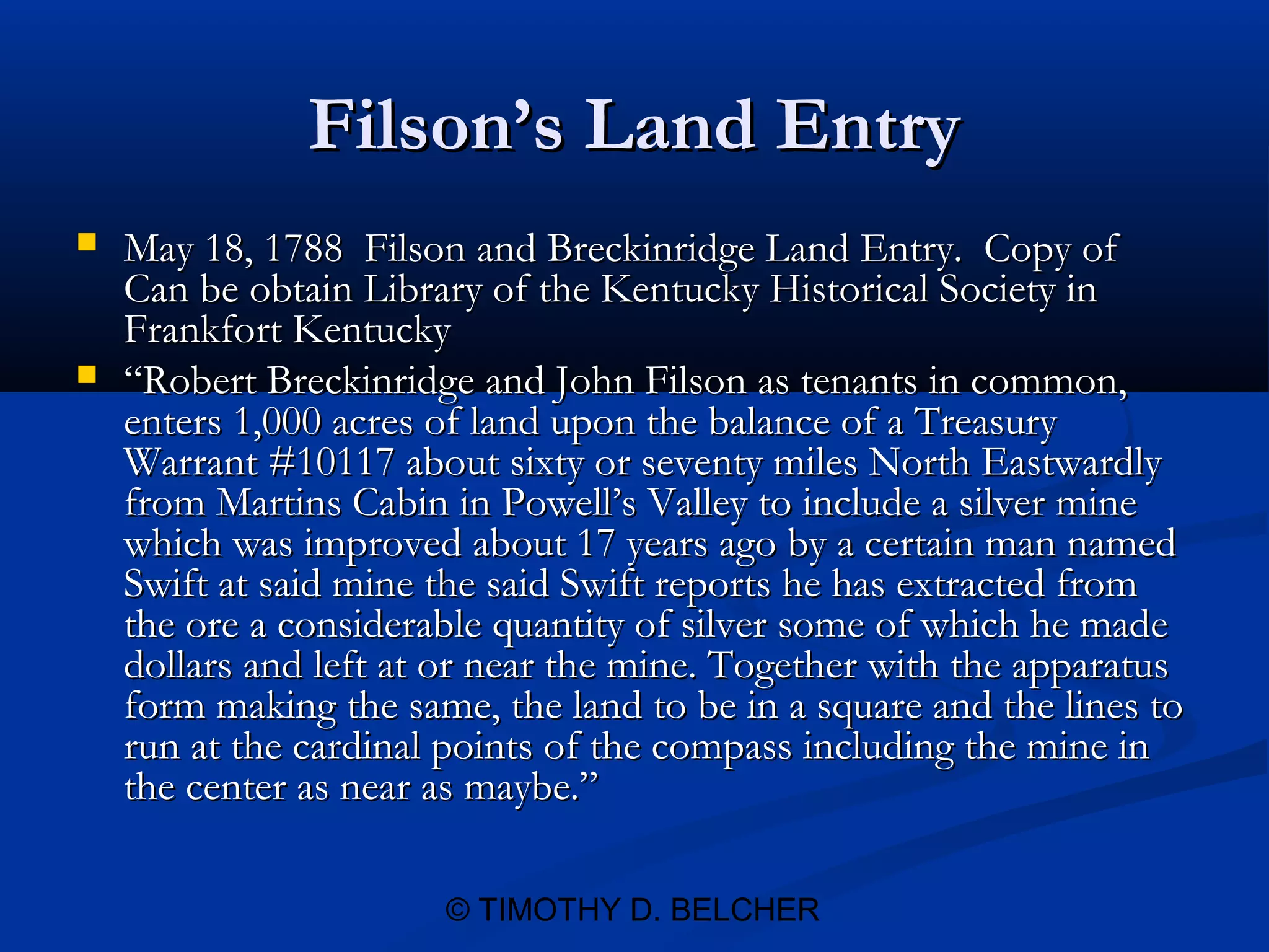
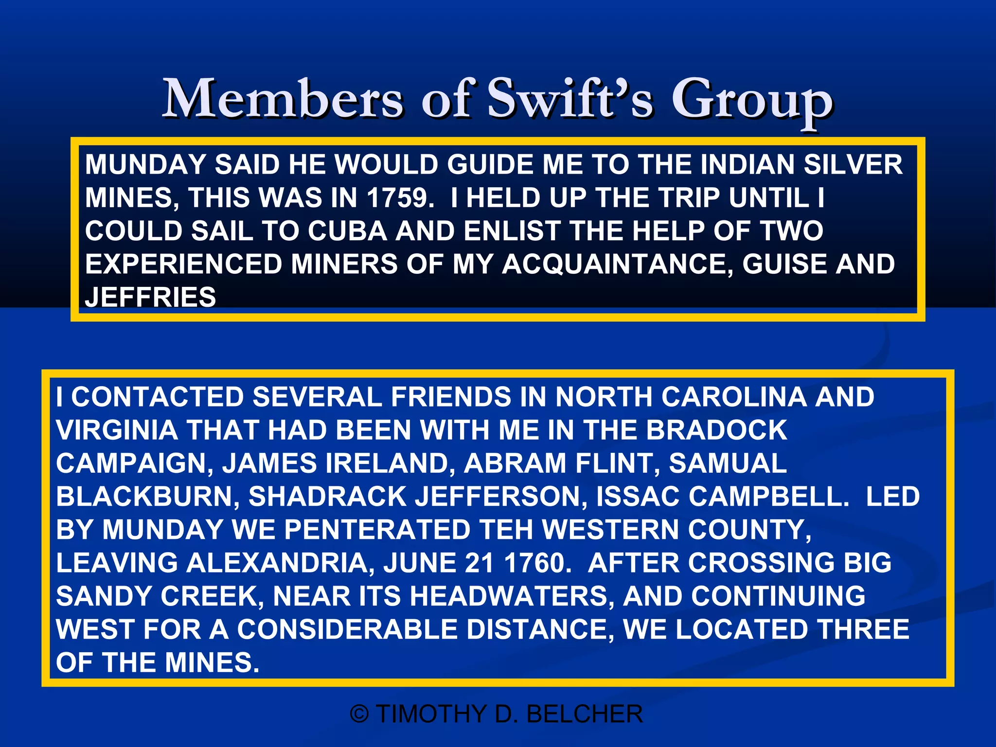
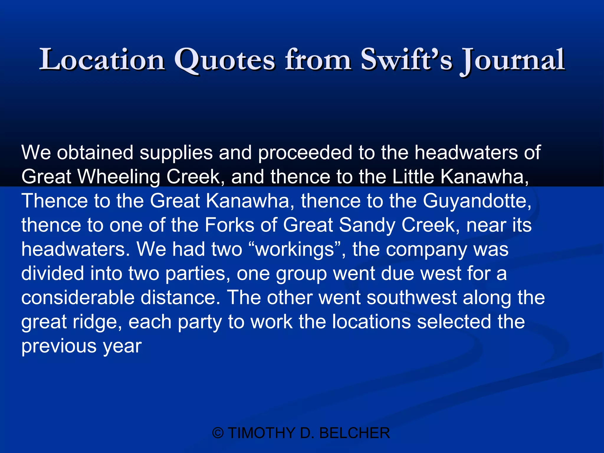
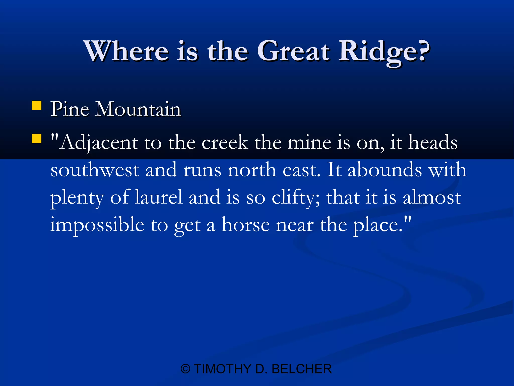
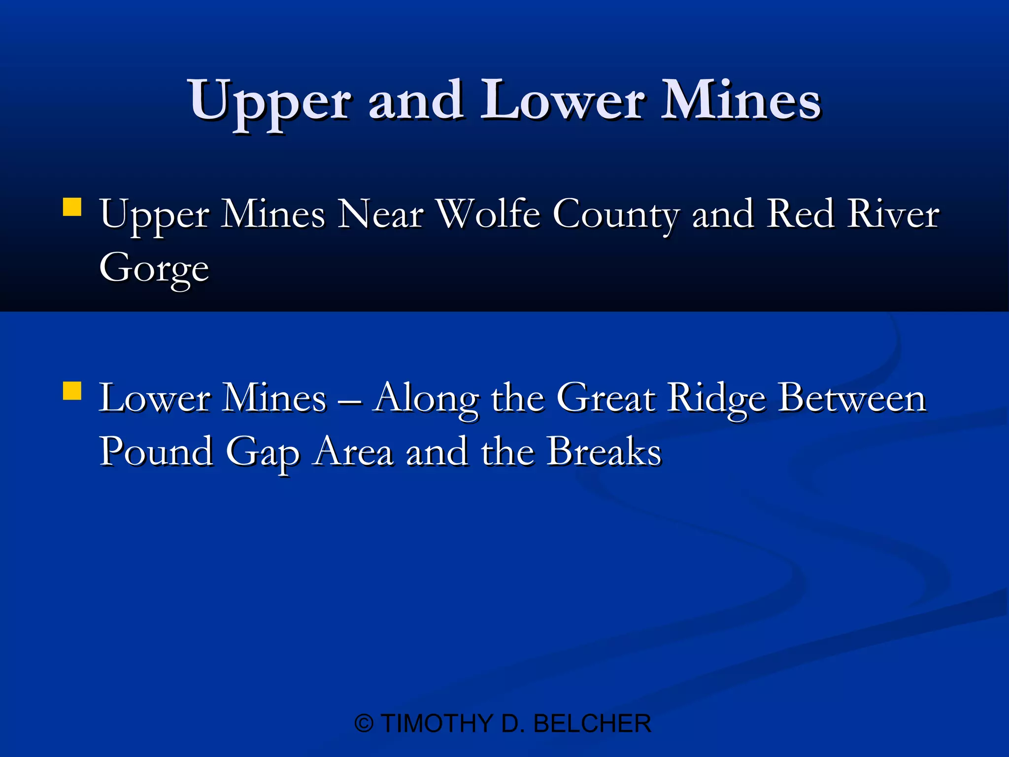
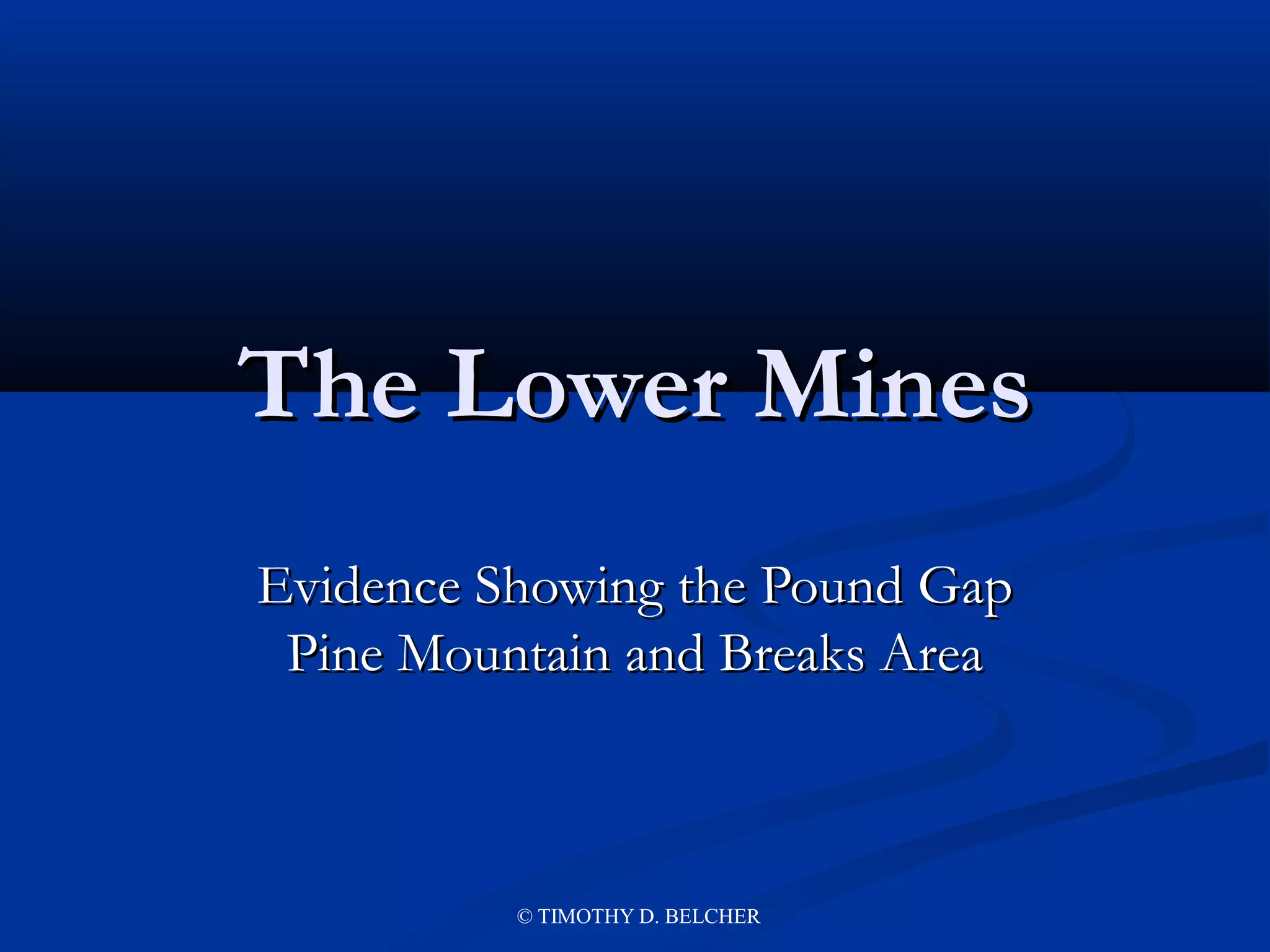
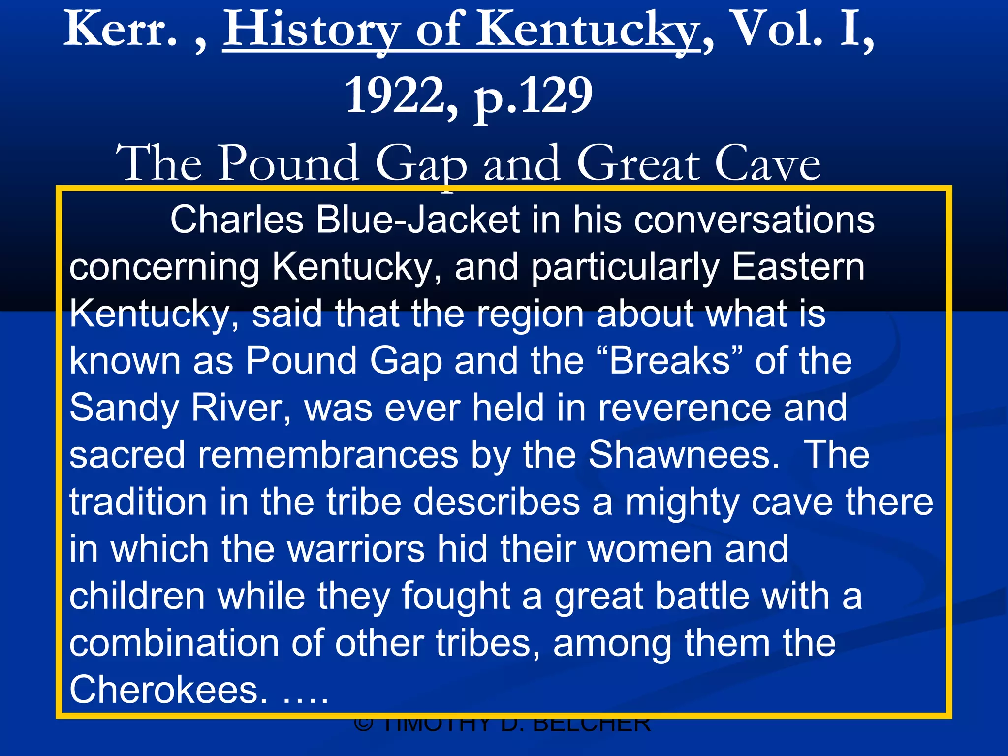
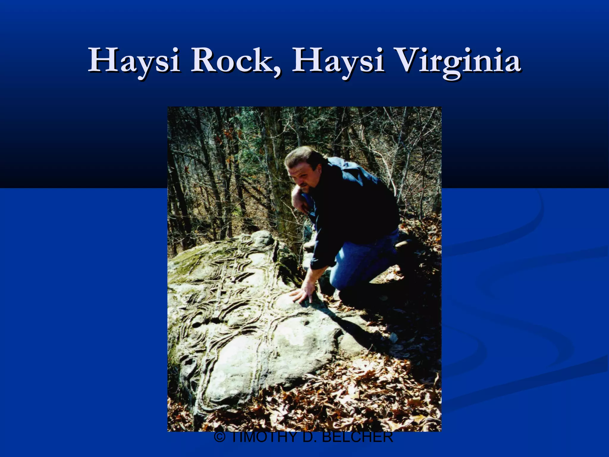
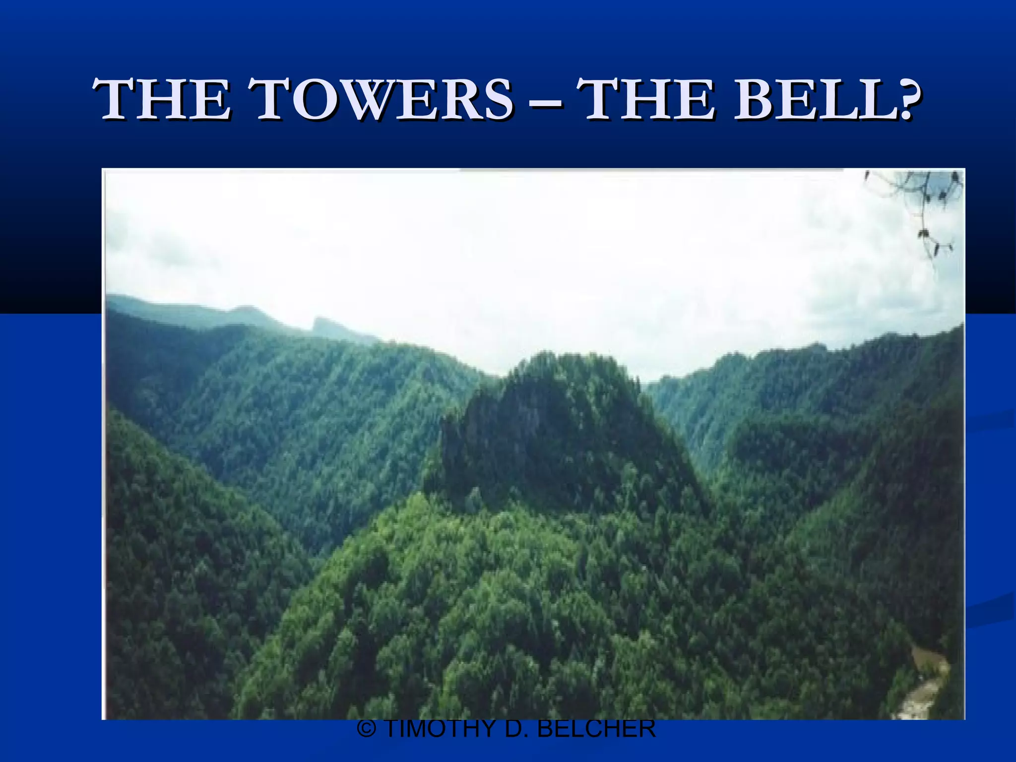
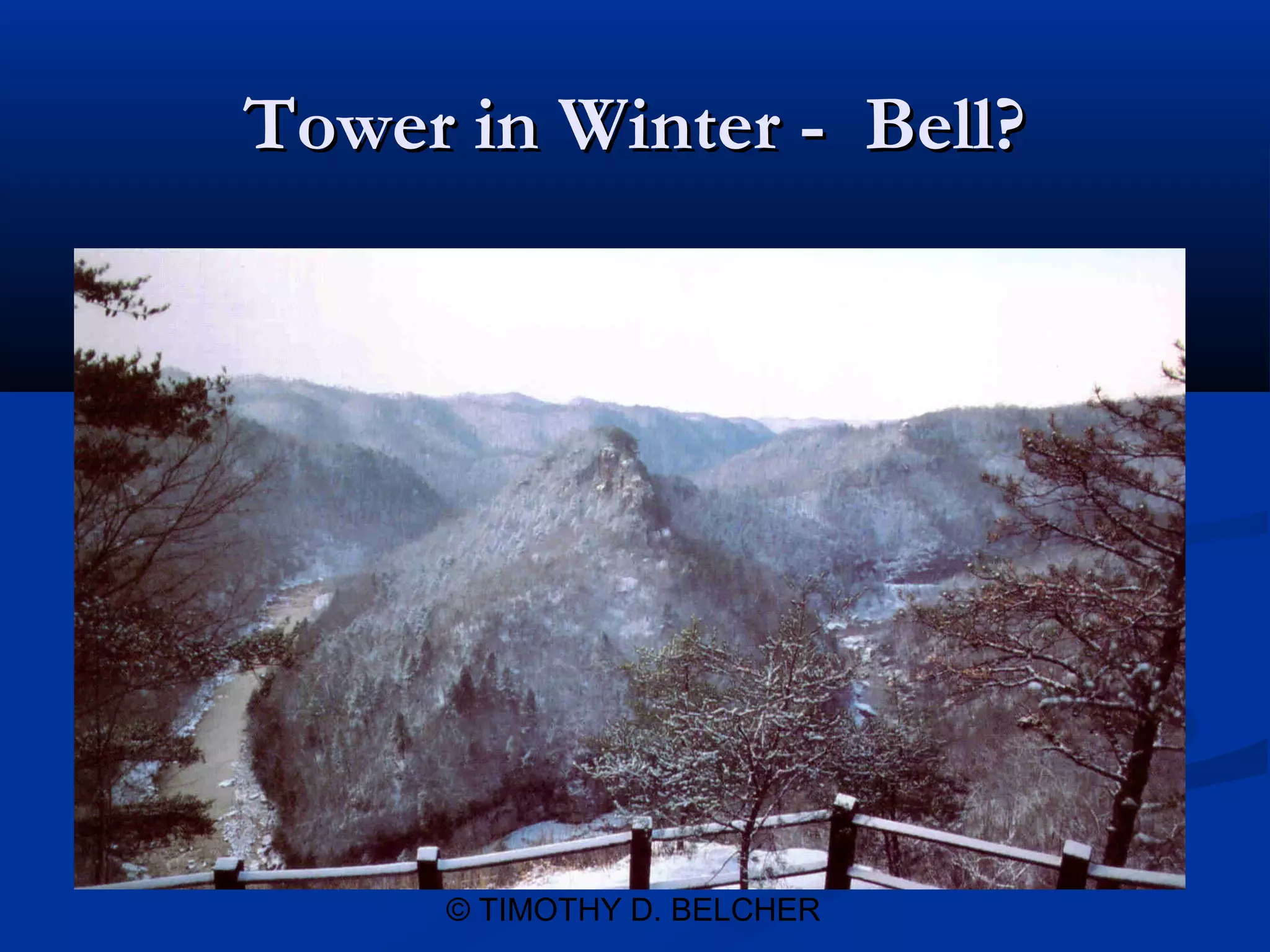
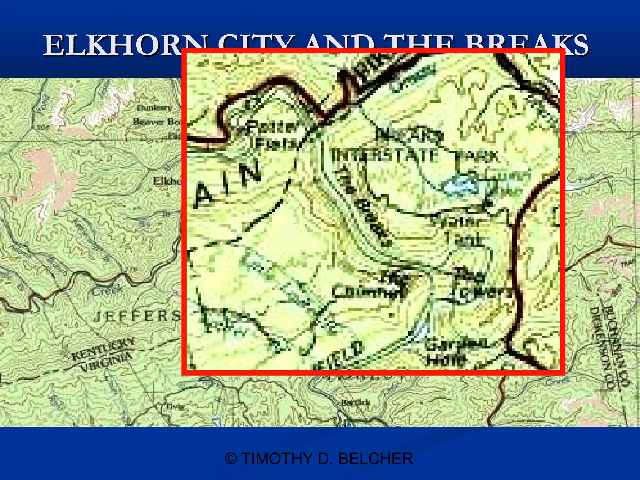
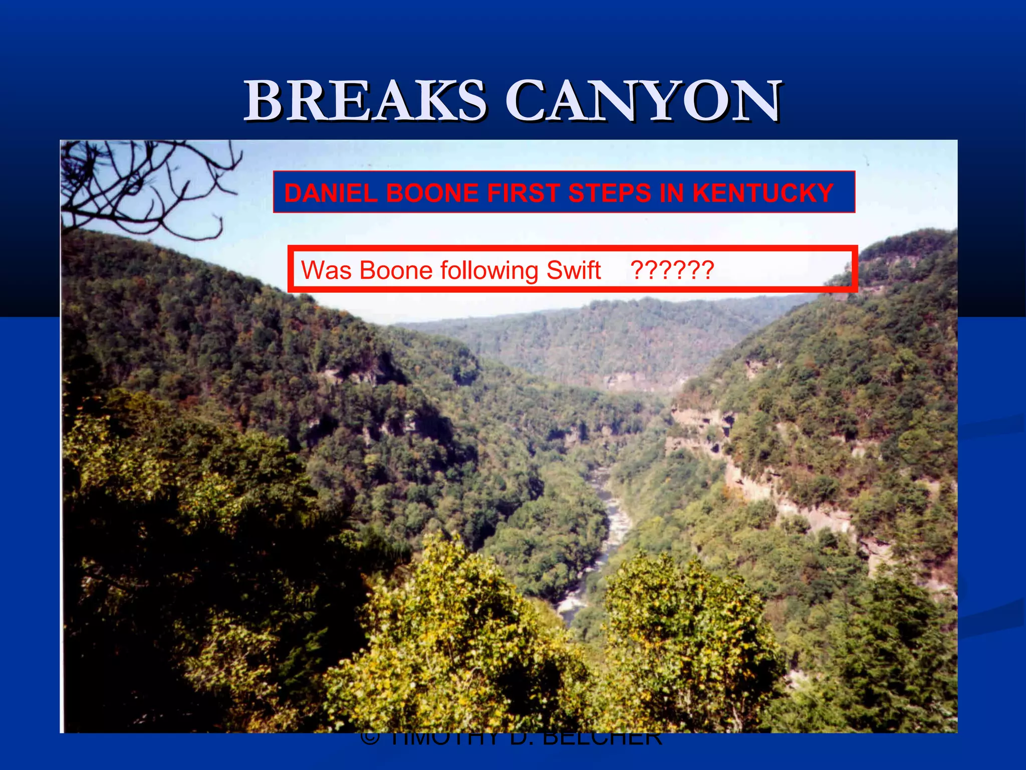
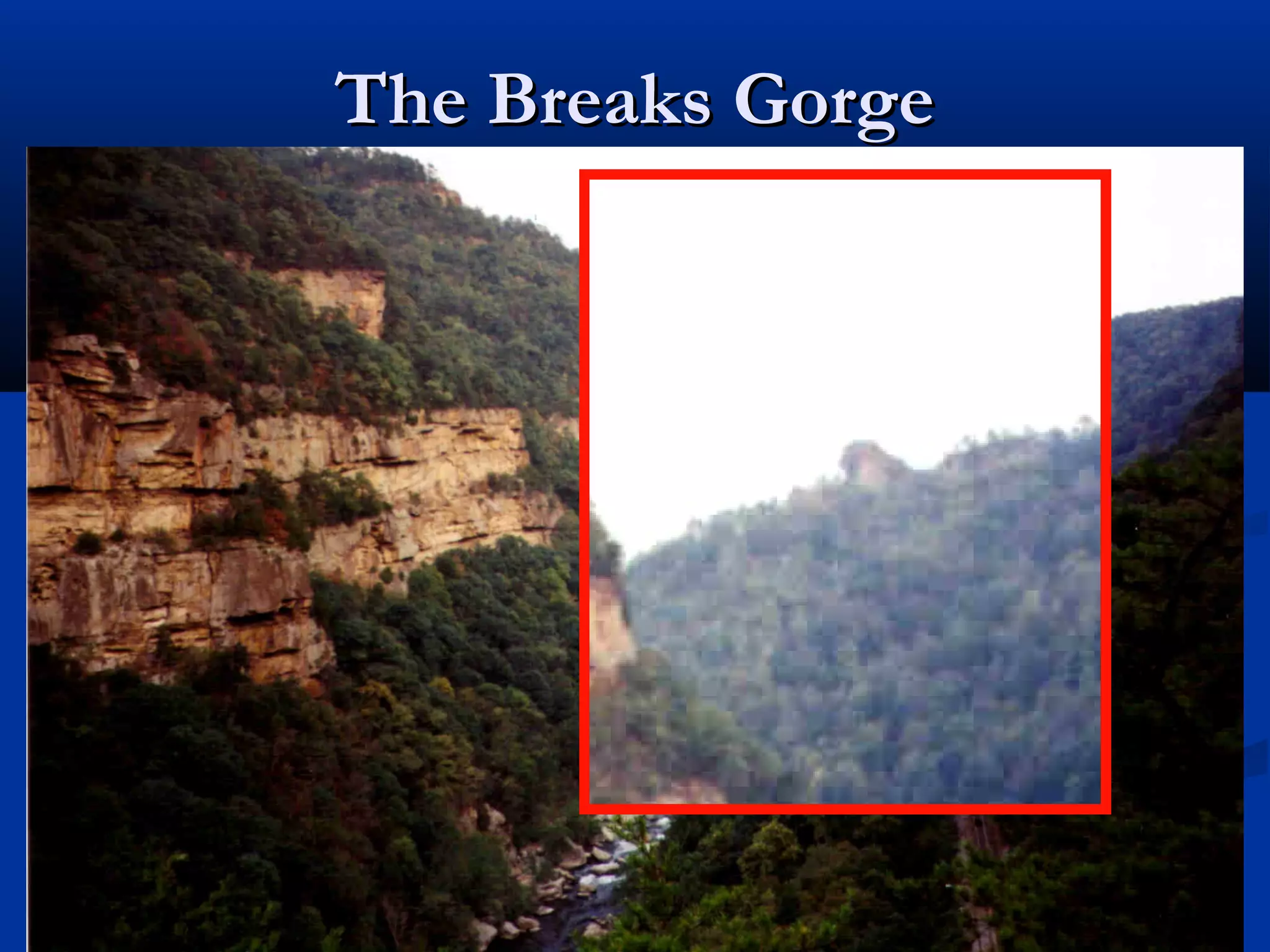
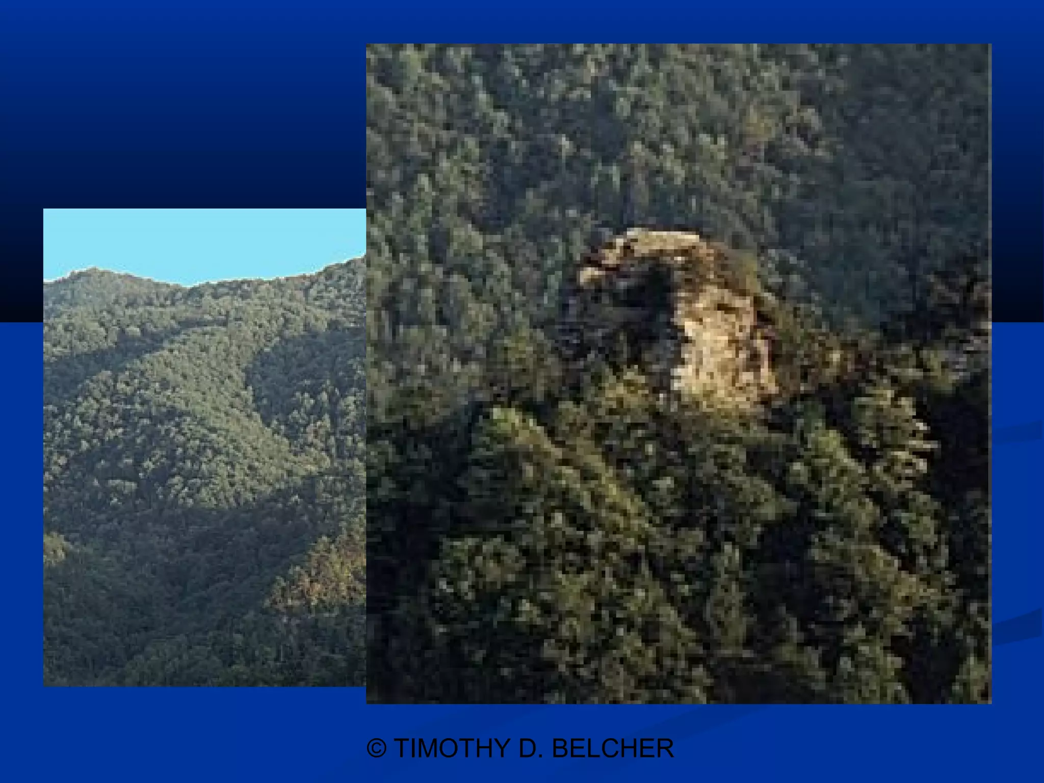
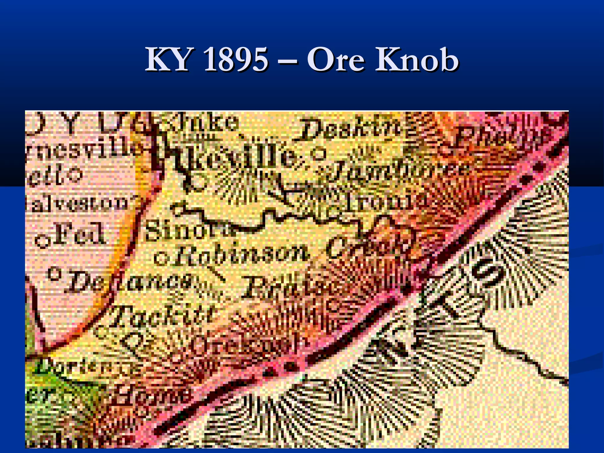
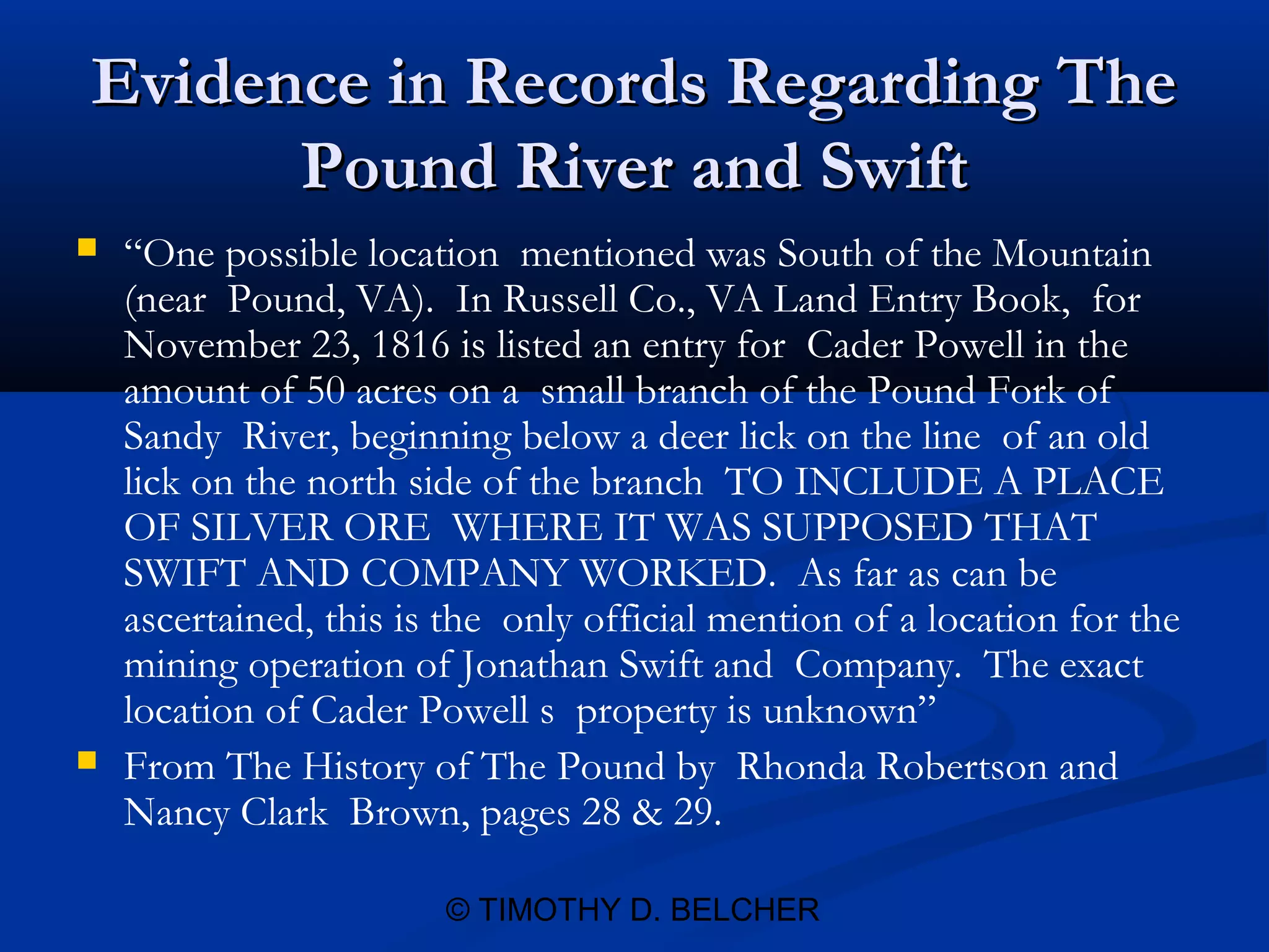
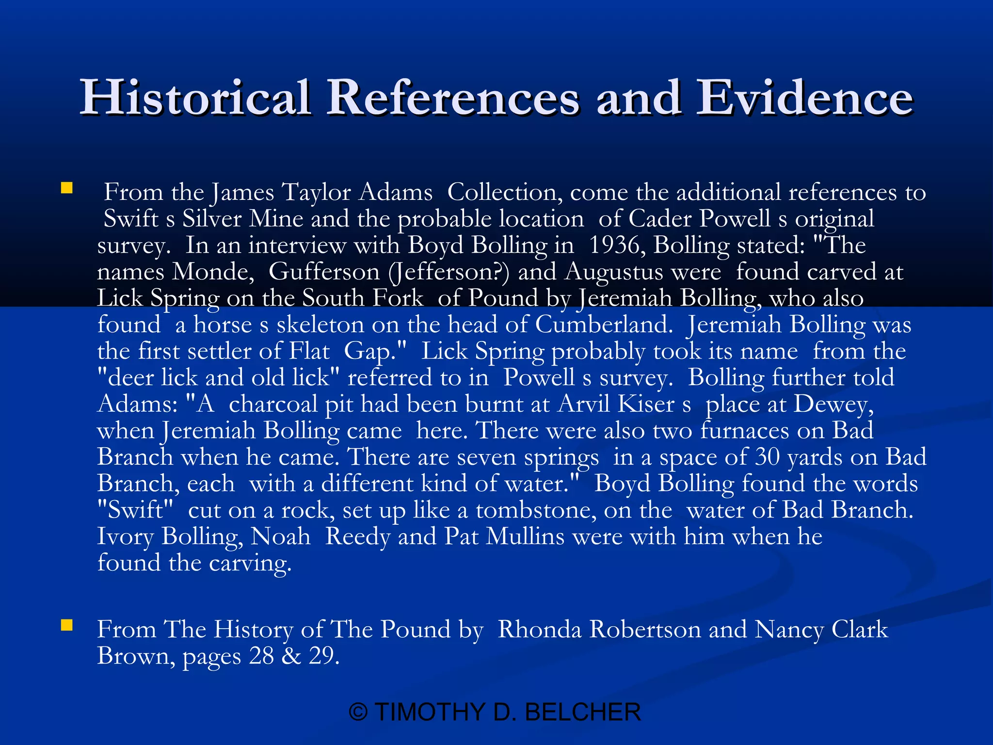
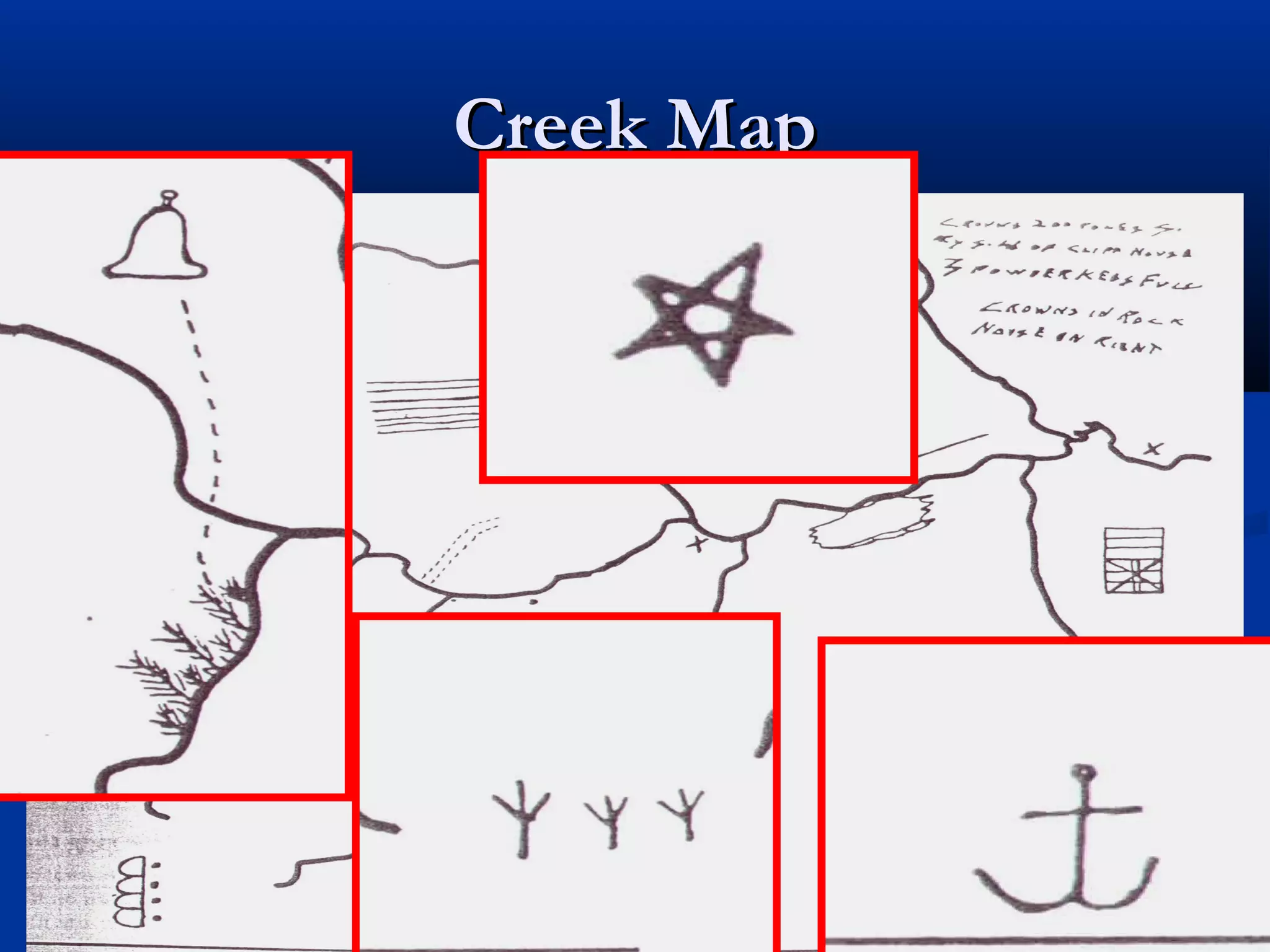
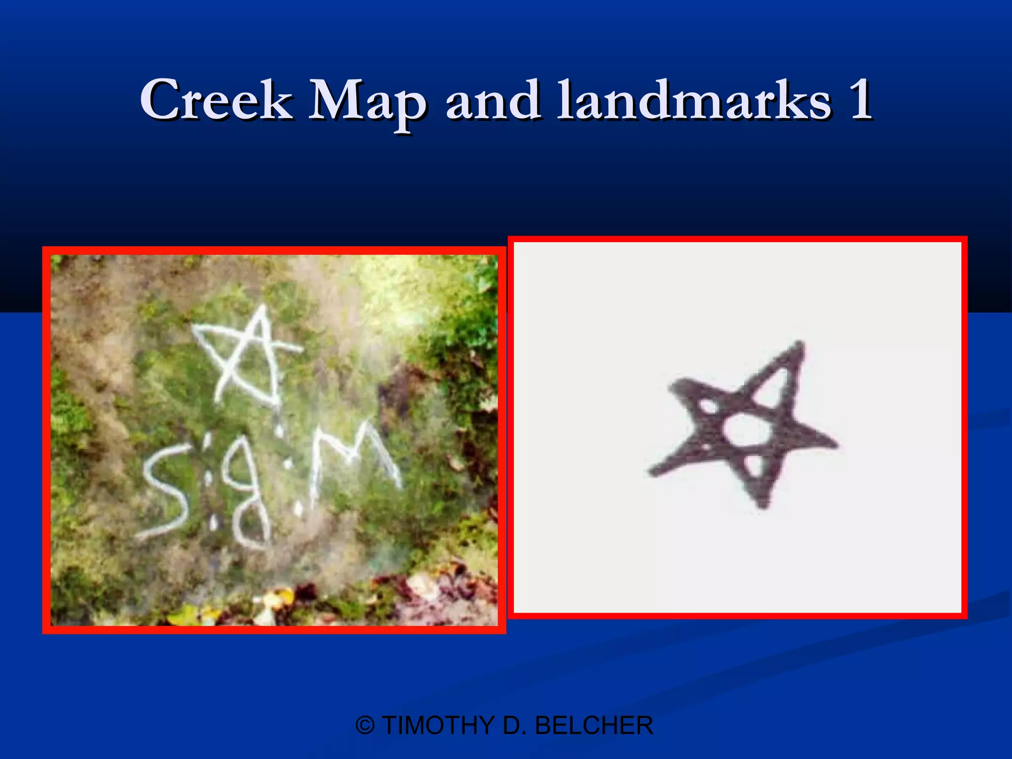
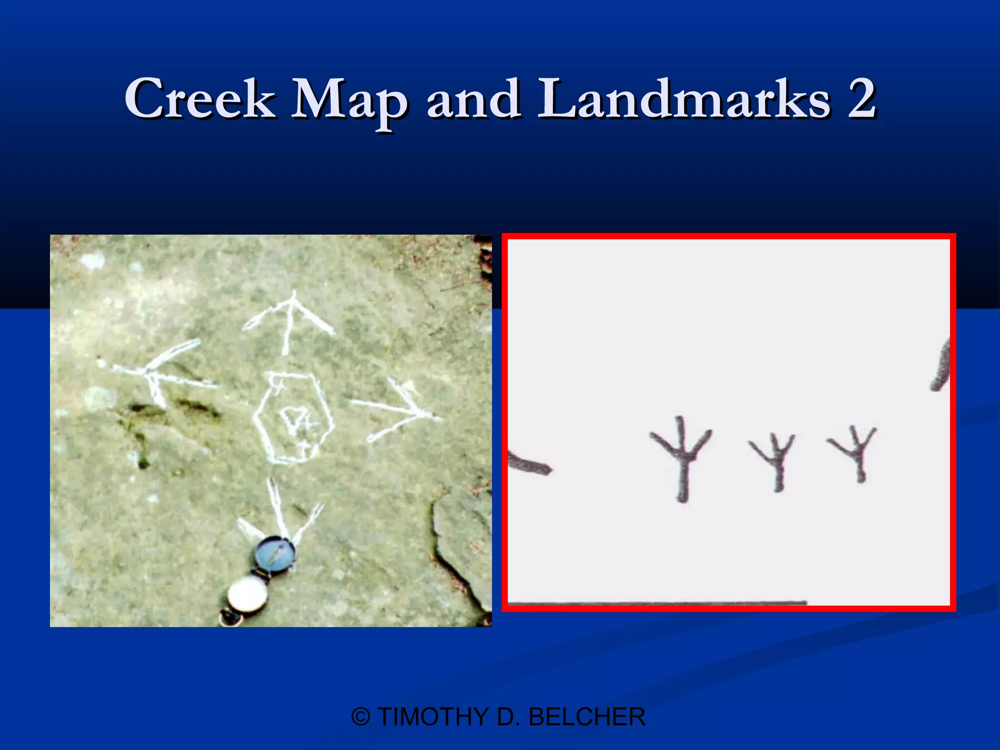
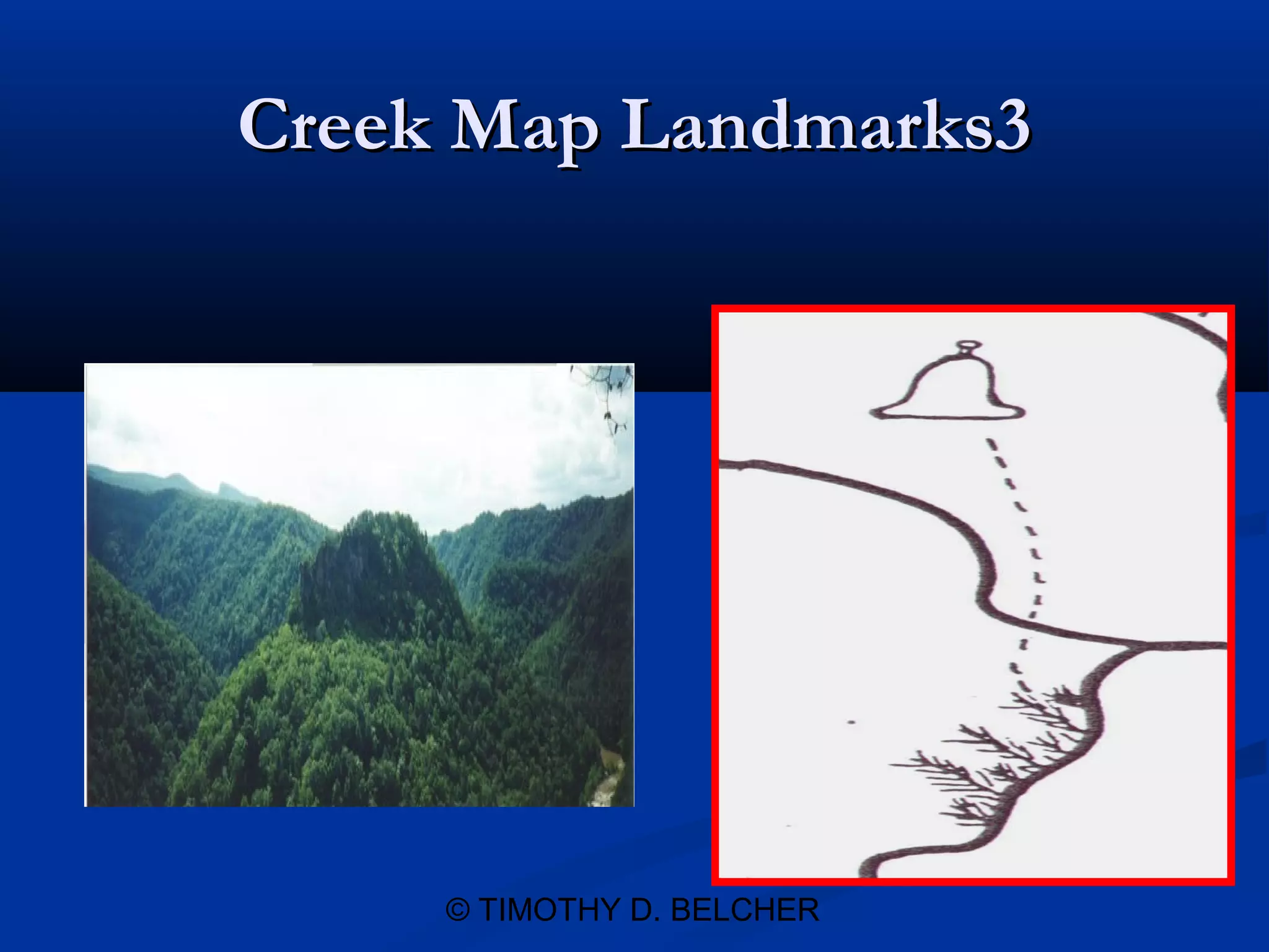
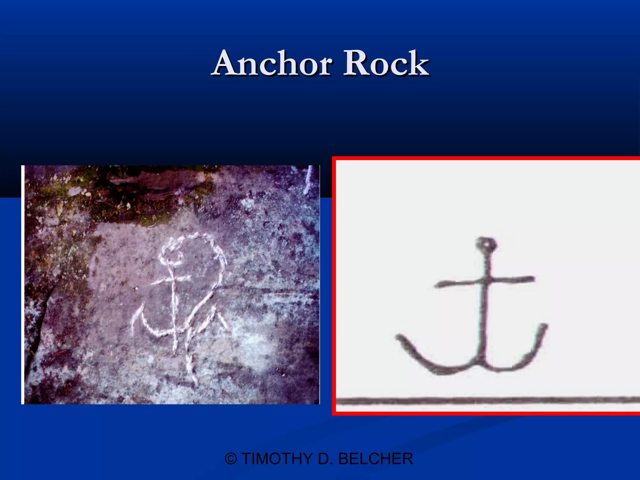
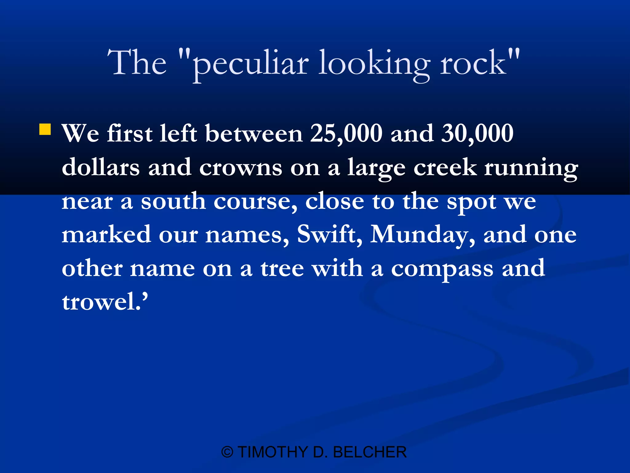
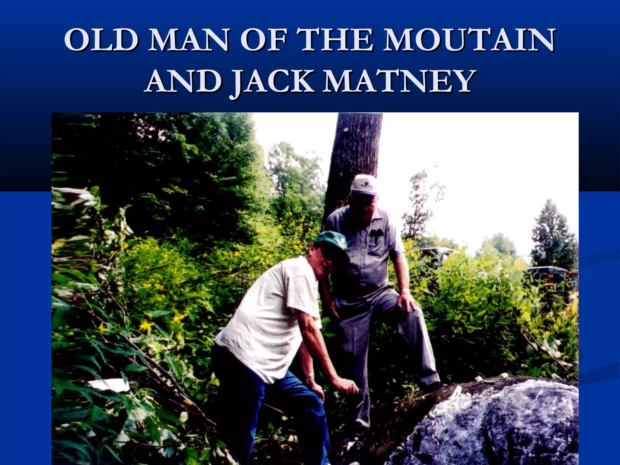
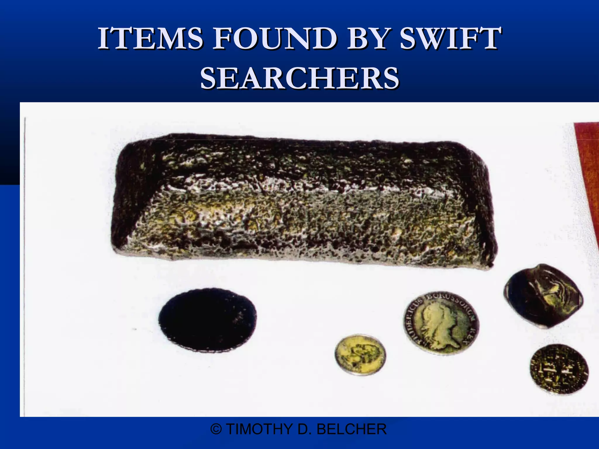
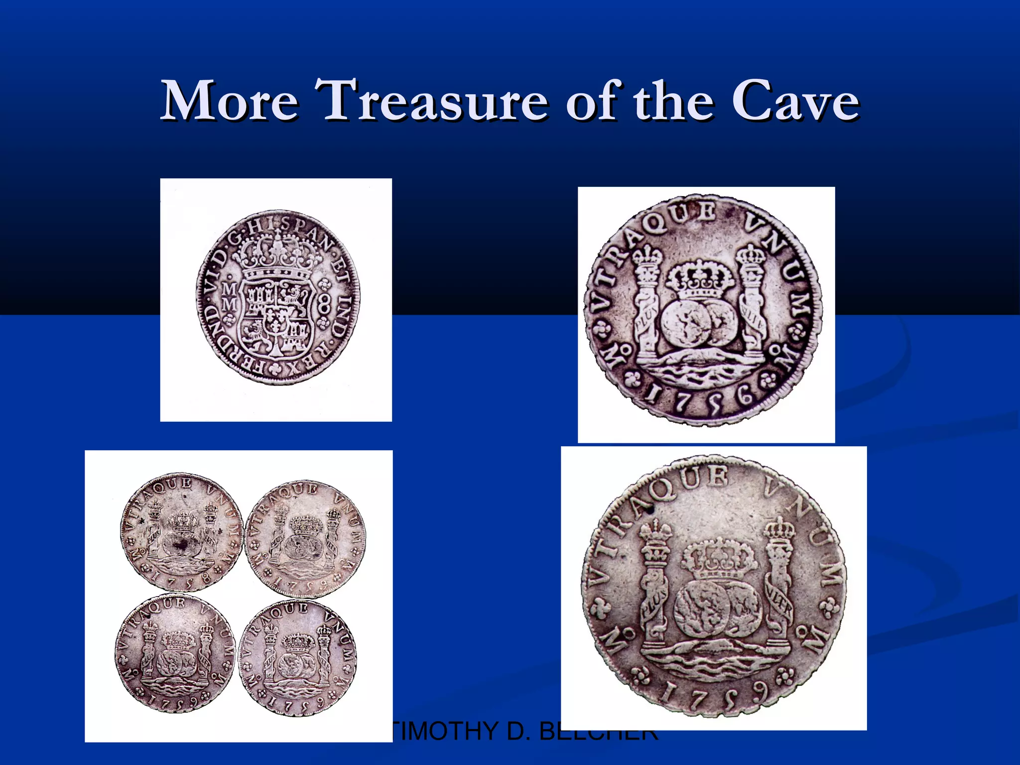
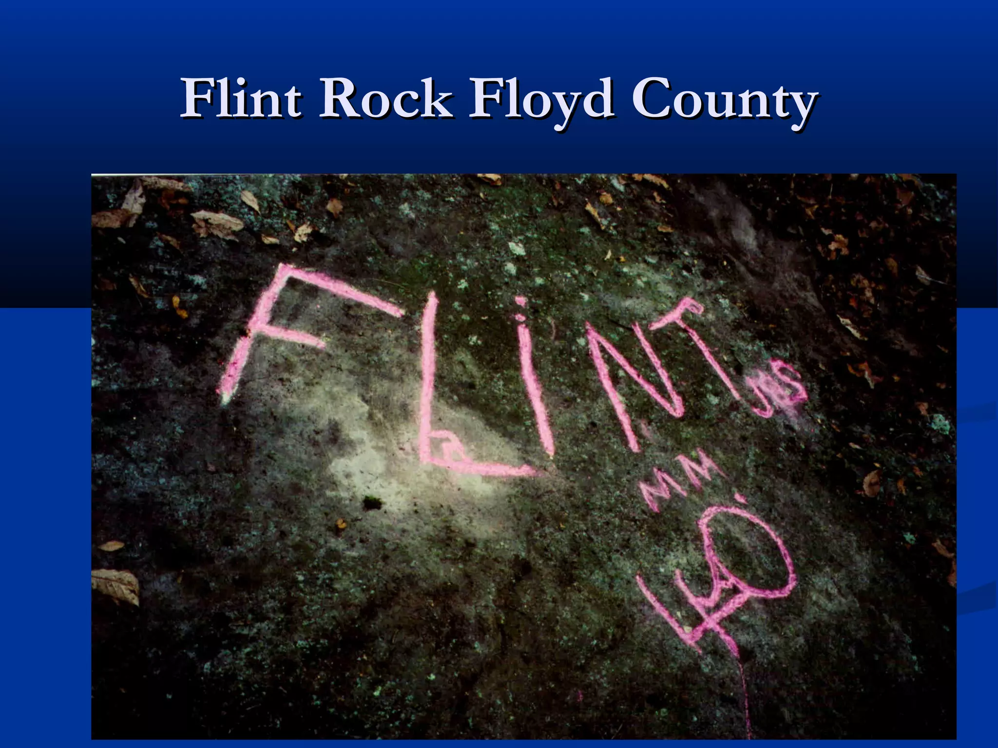
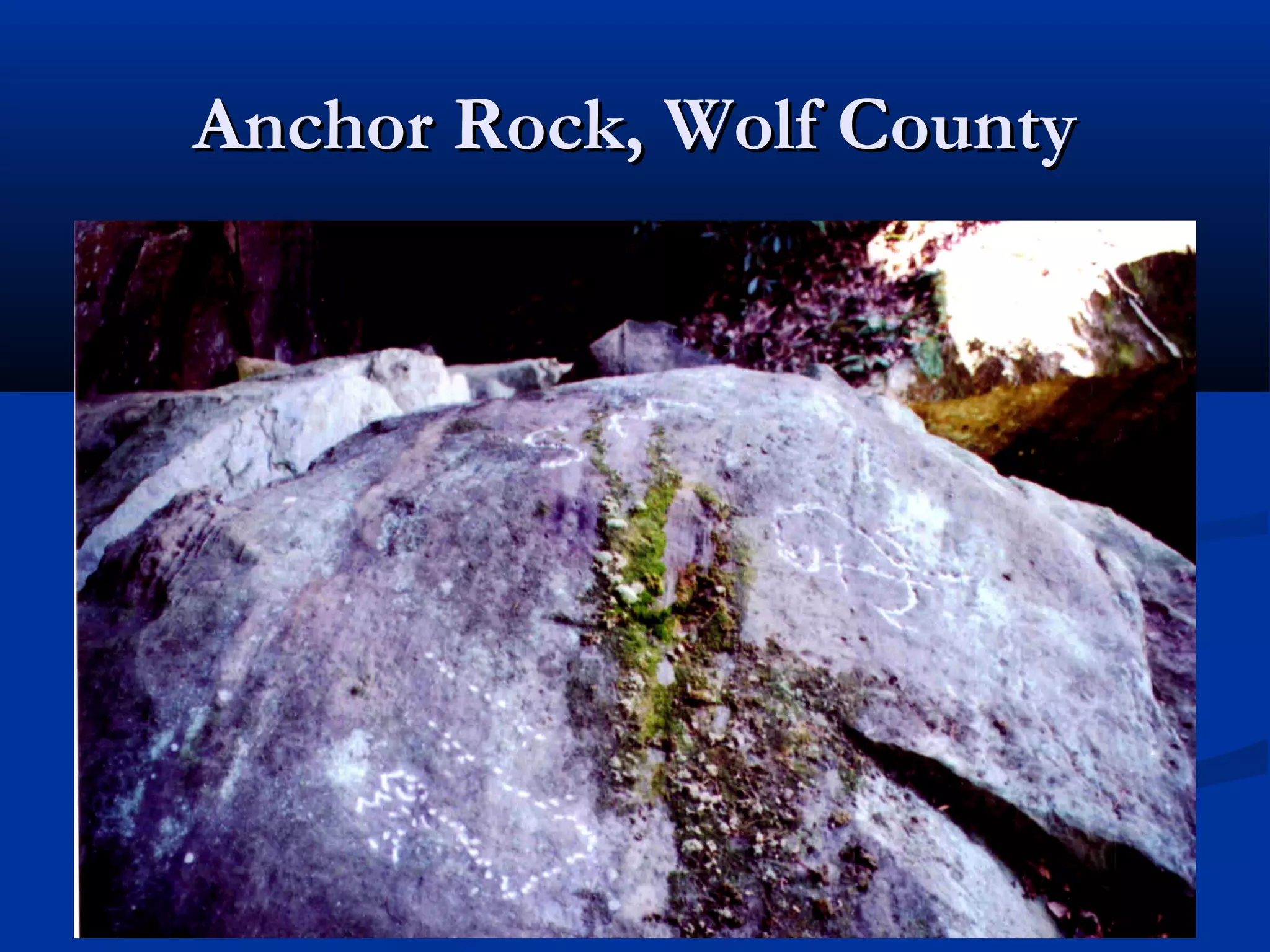
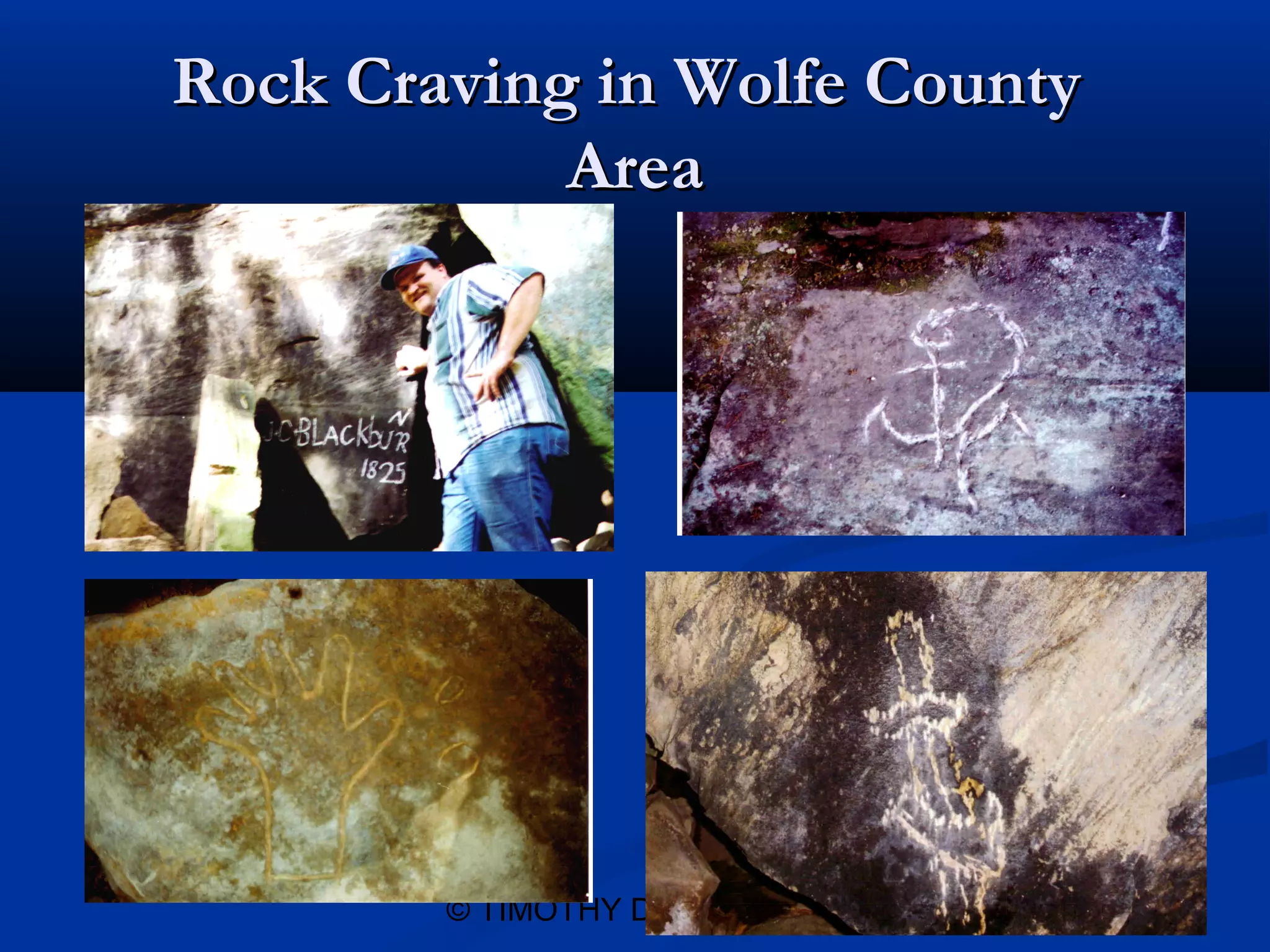
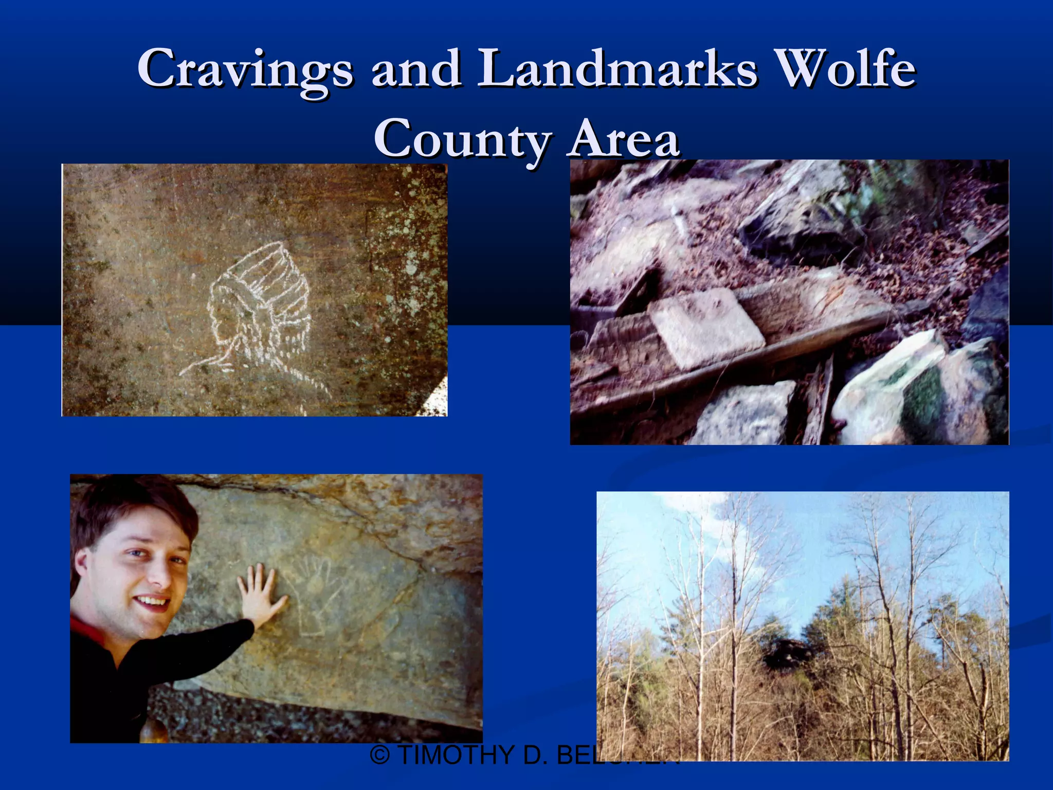
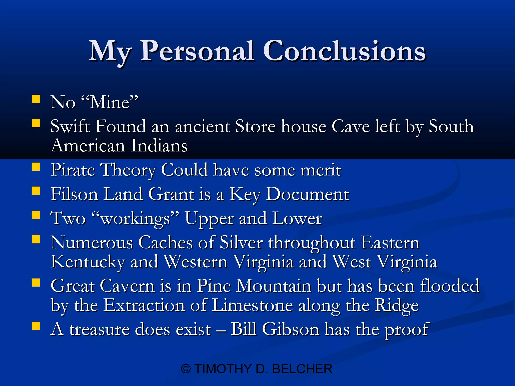
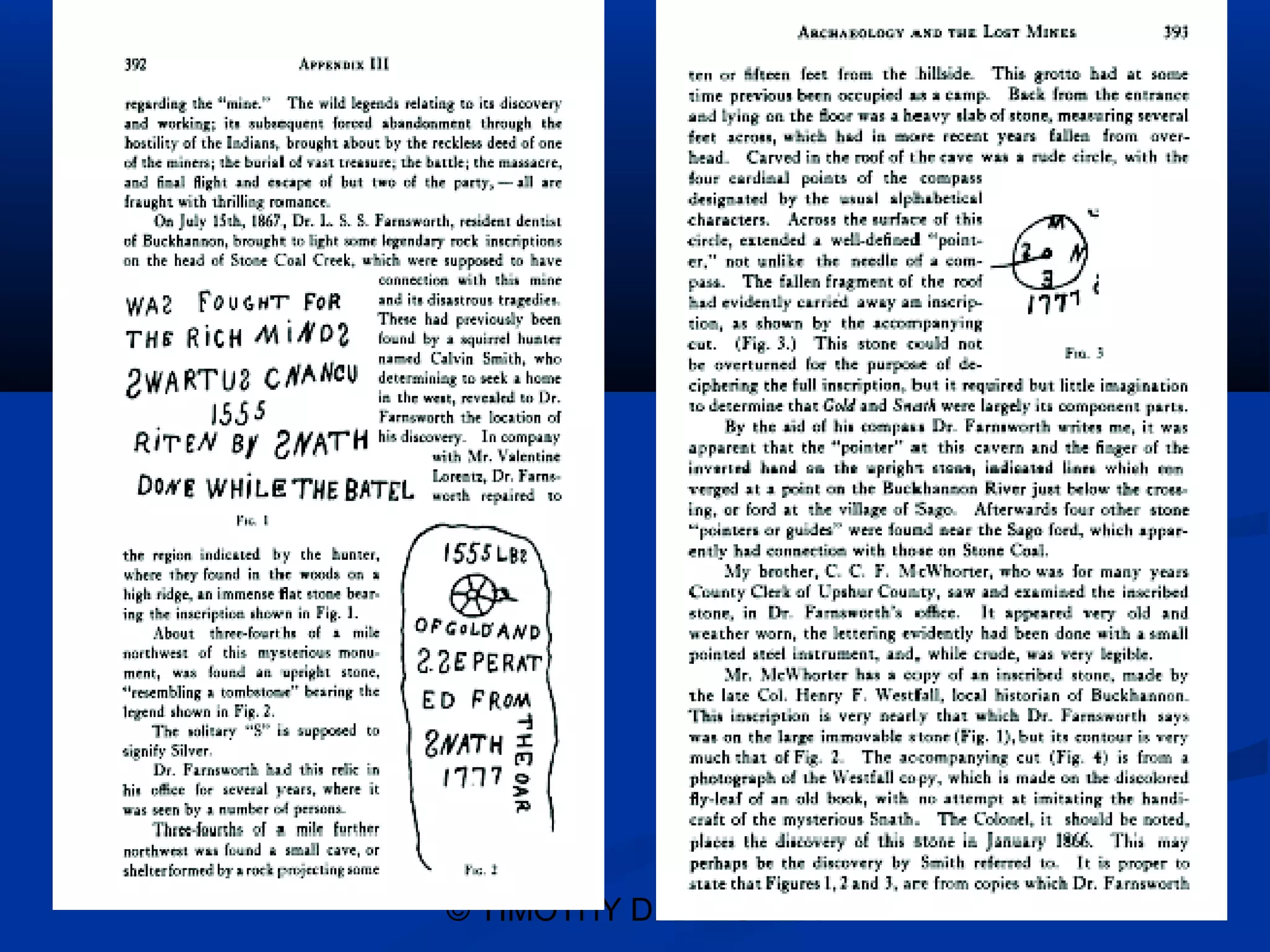
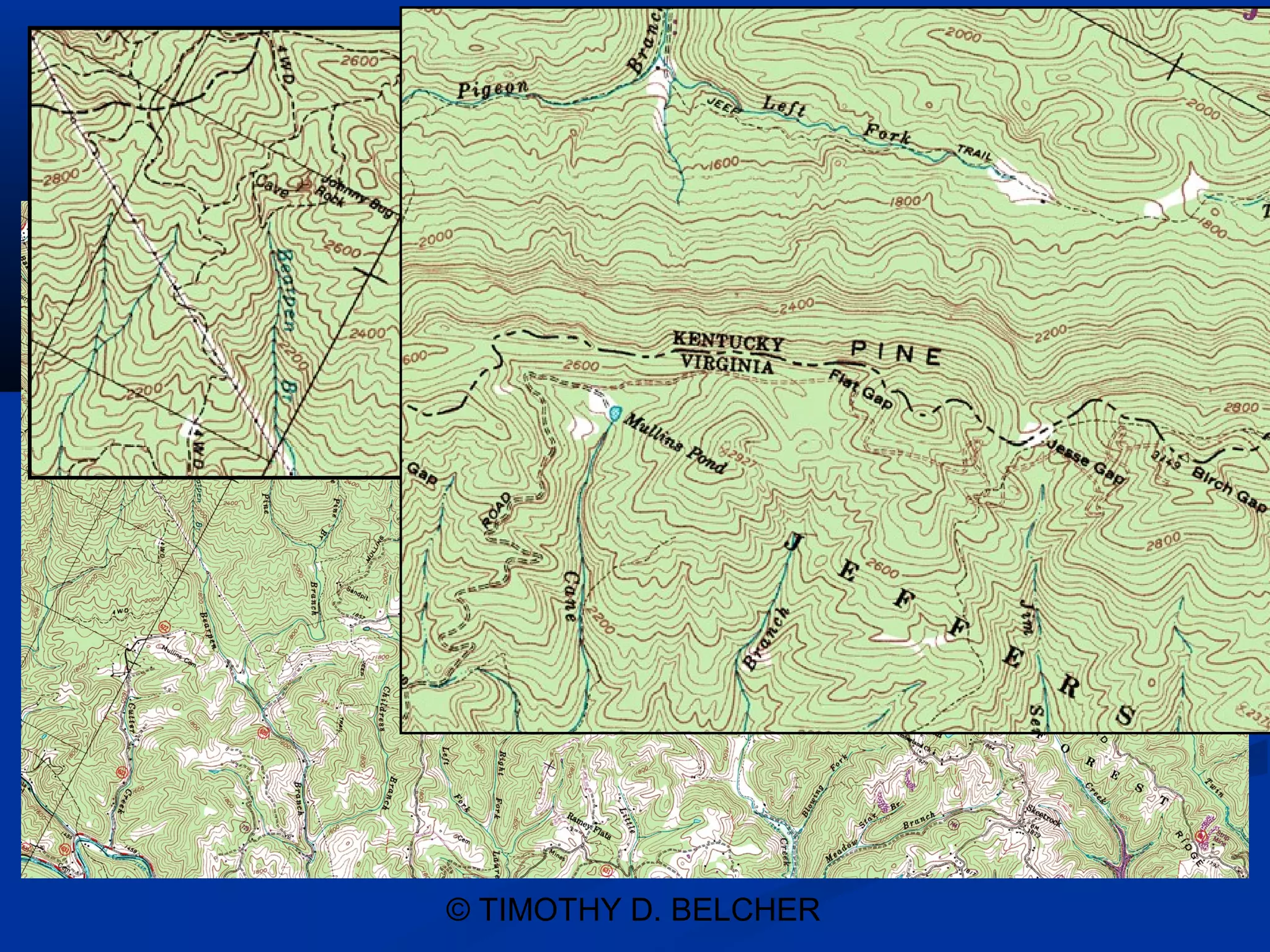
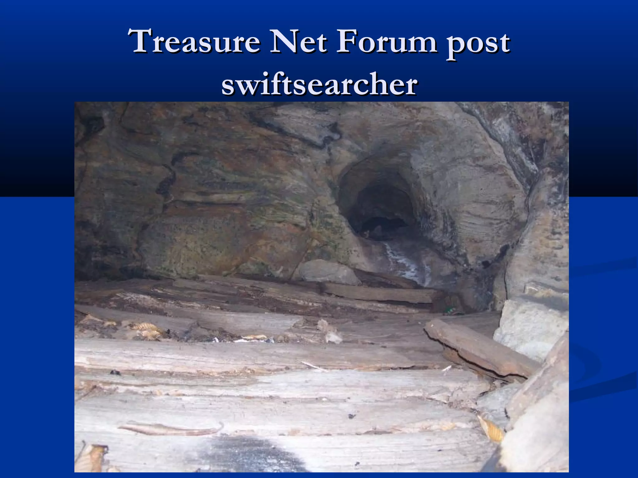
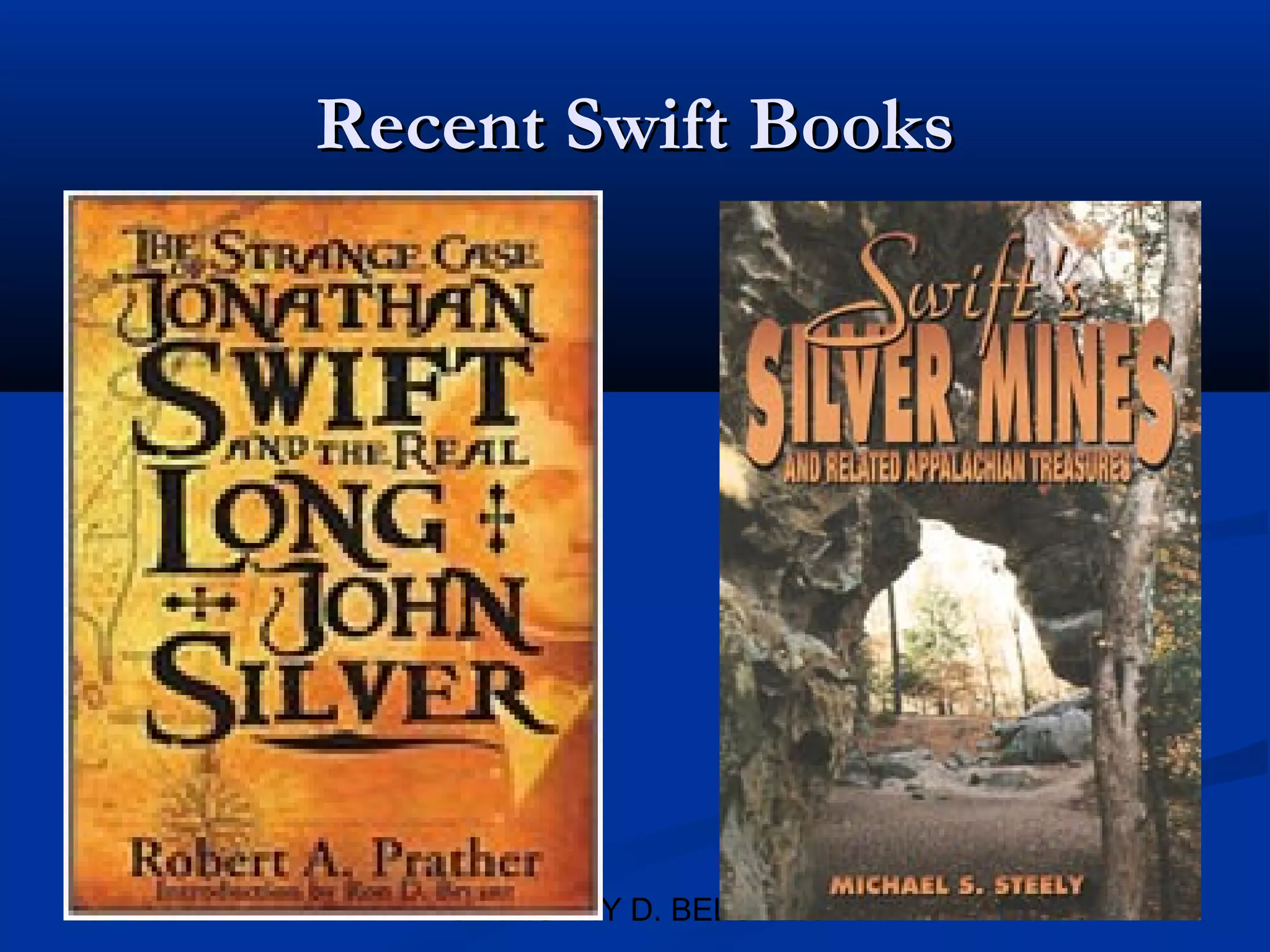
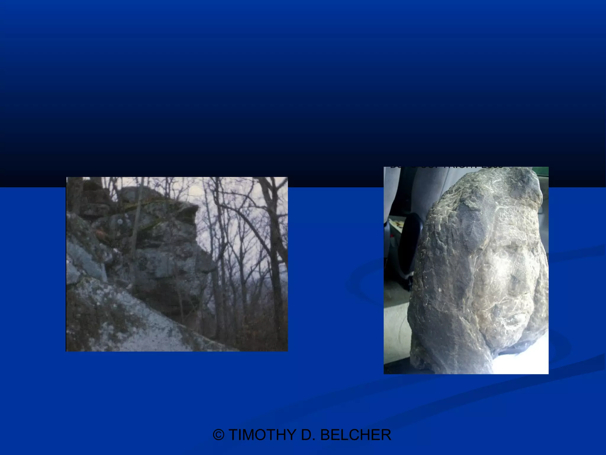
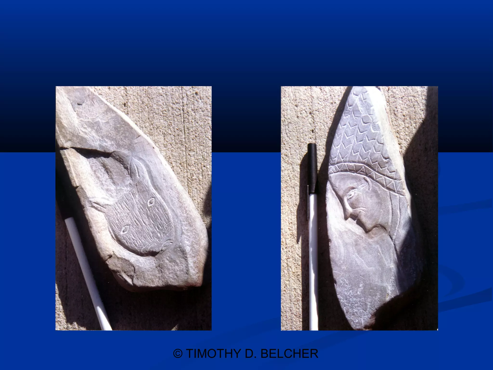
JOHN SWIFT’S
LOST SILVER MINE
AN APPALACHAIN
    MYSTERY
     © TIMOTHY D. BELCHER
TIMOTHY D. BELCHER
    ATTORNEY AT LAW
135 WEST RUSSELL STREET
       P.O. BOX 1195
 ELKHORN CITY, KY 41522
      (606)754-7150
           EMAIL:
 timothydbelcher@hotmail.com
          © TIMOTHY D. BELCHER
The Elkhorn City Area
Heritage Council, Inc.
    Past, Present and Future
    Experience Your Heritage


           © TIMOTHY D. BELCHER
ELKHORN CITY CEMETERY PROJECT
     POTTER FLATS – PIONEER VILLAGE
   ARCHIVES PROJECT AND ORAL HISTORY
   RUSSELL FORK CLEANUP PROJECT
ELKHORN CITY AREA HERITAGE CENTER PROJECT
       SPEAKERS’ BUREAU PROJECT
      THE OLD THEATER PROJECT

  THE ELKORN CITY RAILROAD MUSEUM


            © TIMOTHY D. BELCHER
SWIFT MARKER AT CAMPTON


      © TIMOTHY D. BELCHER
WHO WAS SHIFT?
“I became a trader amongst the Cherokee in
North Carolina and the Tennessee County, I
went with General Braddock in the attack on
Fort Duquesne, at the forks of the Ohio River.
After our defeat in 1755, I returned to
Alexandria and my occupation as a silver-smith
and trader amongst the Indians.”
From Swift’s Journal as Published by Michael
Paul Henson.

               © TIMOTHY D. BELCHER
Theories of Existence of Mine
   Pirate Theory             Masonic Theory
   Revolution Theory         Actual Silver Mine
   Ancient South              Theory
    American Theory
   American Indian


                © TIMOTHY D. BELCHER
Historical Men Who Knew of Swift
   Col. James Harrod, Founder of Harrodsburg,
    died while in search of the mines along the 3
    forks of the Kentucky River.
   John Filson, Kentucky First Historian Obtained
    a land grant which referenced the Swift Silver
    Mine. (This grant actually puts the mines near
    Pine Mountain Between Pound Gap and the
    Breaks.

                  © TIMOTHY D. BELCHER
Filson’s Land Entry
   May 18, 1788 Filson and Breckinridge Land Entry. Copy of
    Can be obtain Library of the Kentucky Historical Society in
    Frankfort Kentucky
   “Robert Breckinridge and John Filson as tenants in common,
    enters 1,000 acres of land upon the balance of a Treasury
    Warrant #10117 about sixty or seventy miles North Eastwardly
    from Martins Cabin in Powell’s Valley to include a silver mine
    which was improved about 17 years ago by a certain man named
    Swift at said mine the said Swift reports he has extracted from
    the ore a considerable quantity of silver some of which he made
    dollars and left at or near the mine. Together with the apparatus
    form making the same, the land to be in a square and the lines to
    run at the cardinal points of the compass including the mine in
    the center as near as maybe.”

                       © TIMOTHY D. BELCHER
Members of Swift’s Group
 MUNDAY SAID HE WOULD GUIDE ME TO THE INDIAN SILVER
 MINES, THIS WAS IN 1759. I HELD UP THE TRIP UNTIL I
 COULD SAIL TO CUBA AND ENLIST THE HELP OF TWO
 EXPERIENCED MINERS OF MY ACQUAINTANCE, GUISE AND
 JEFFRIES


I CONTACTED SEVERAL FRIENDS IN NORTH CAROLINA AND
VIRGINIA THAT HAD BEEN WITH ME IN THE BRADOCK
CAMPAIGN, JAMES IRELAND, ABRAM FLINT, SAMUAL
BLACKBURN, SHADRACK JEFFERSON, ISSAC CAMPBELL. LED
BY MUNDAY WE PENTERATED TEH WESTERN COUNTY,
LEAVING ALEXANDRIA, JUNE 21 1760. AFTER CROSSING BIG
SANDY CREEK, NEAR ITS HEADWATERS, AND CONTINUING
WEST FOR A CONSIDERABLE DISTANCE, WE LOCATED THREE
OF THE MINES.
                 © TIMOTHY D. BELCHER
Location Quotes from Swift’s Journal

We obtained supplies and proceeded to the headwaters of
Great Wheeling Creek, and thence to the Little Kanawha,
Thence to the Great Kanawha, thence to the Guyandotte,
thence to one of the Forks of Great Sandy Creek, near its
headwaters. We had two “workings”, the company was
divided into two parties, one group went due west for a
considerable distance. The other went southwest along the
great ridge, each party to work the locations selected the
previous year


                     © TIMOTHY D. BELCHER
Where is the Great Ridge?
   Pine Mountain
   "Adjacent to the creek the mine is on, it heads
    southwest and runs north east. It abounds with
    plenty of laurel and is so clifty; that it is almost
    impossible to get a horse near the place."


                    © TIMOTHY D. BELCHER
Upper and Lower Mines
   Upper Mines Near Wolfe County and Red River
    Gorge

   Lower Mines – Along the Great Ridge Between
    Pound Gap Area and the Breaks


                 © TIMOTHY D. BELCHER
The Lower Mines
Evidence Showing the Pound Gap
 Pine Mountain and Breaks Area


          © TIMOTHY D. BELCHER
Kerr. , History of Kentucky, Vol. I,
             1922, p.129
  The Pound Gap and Great Cave
       Charles Blue-Jacket in his conversations
concerning Kentucky, and particularly Eastern
Kentucky, said that the region about what is
known as Pound Gap and the “Breaks” of the
Sandy River, was ever held in reverence and
sacred remembrances by the Shawnees. The
tradition in the tribe describes a mighty cave there
in which the warriors hid their women and
children while they fought a great battle with a
combination of other tribes, among them the
Cherokees. ….
                 © TIMOTHY D. BELCHER
© TIMOTHY D. BELCHER
Kerr, Bluejacket’s description of the
           Great Cavern
In his description of the cave he said that it
extended from one side of the mountain to the
other, being many miles in extent, and that it
could be entered at several different points
and on both sides of the great mountain range
under which it lay. Some of the principal
mines worked by Swift and his companions
were in the vicinity of this great cave, and they
finally made it the storehouse for all their
surplus production of silver. They carefully
covered the entrances to the cavern when
they departed from the D. BELCHER
                © TIMOTHY country.
Kerr, Secret Society of Shawnee
The Shawnees and the Wyandots often went to
this country to hunt, even after Easter Kentucky
was settled by the white people. Charles Blue-
Jacket’s father went into the cave on more than
one occasion. He had not been with Swift, but his
father had been. There is a secret religious
society among the Shawnees, which
preserves many of the rites of the old
pagan life, and this great cave had some
significance in the ritual of that order.
               © TIMOTHY D. BELCHER
Found on Pine Mountain


     © TIMOTHY D. BELCHER
LOST ART OF SHAWNEE
"CORNSTALK" WAS THE RESPECTED CHIEF OF THE
SHAWNEE INDIANS WHO LIVED IN THE OHIO RIVER
VALLEY IN 1777. WHILE VISITING CAPTAIN WILIAM
MCKEE, HE SAID THAT "OHIO AND KENTUCKY HAD
ONCE BEEN SETLED BY A WHITE RACE POSSESSED OF
ARTS OF WHICH THE INDIANS HAD NO KNOWLEDGE,
THAT AFTER MANY SANGUINARY CONTESTS WITH THE
NATIVES THESE INVADERS WERE AT LENGTH
TERMINATED." CORNSTALK ALSO TOLD THEM THAT
"THE GREAT SPIRIT HAD ONCE GIVEN THE INDIANS A
BOOK WHICH TAUGHT THEM ALL THESE ARTS; BUT
THEY HAD LOST IT AND HAD NEVER SINCE REGAINED A
KNOWLEDGE OF THEM."

      ABOVE QUOTED FORM, CHEESMAN, ANCIENT
NORTH AMERICAN CULTURES, (1991) P.33 WHICH CITES
TO DRAPER COLLECTION
               © TIMOTHY D. BELCHER
Kerr, Description of Pound Gap
To the hoof-beats of the horse along the roadway through Pound Gap
the mountain sounds like it was hollow, especially when the solid rock
is trodden. At some points in this mountain gap every step seems
echoed through the underground caverns with which it is certain the
mountain is honeycombed. ….. The Shawnees called all this land
“The Country about the Hollow Mountain.” It is evident that the
Indians lived here in considerable numbers at some time in the past,
for many of the ridge-tops are covered with long heaps of loose
stones, plainly carried there, called by the people of the country
“Indian graves.”
         Some parts of the journal of John Swift refer in unmistakable
terms to this region.


                       © TIMOTHY D. BELCHER
Haysi Rock, Haysi Virginia


       © TIMOTHY D. BELCHER
Imlay’s Map of Kentucky Drawn
 around 1790 published in 1793


         © TIMOTHY D. BELCHER
THE TOWERS – THE BELL?


      © TIMOTHY D. BELCHER
Tower in Winter - Bell?


     © TIMOTHY D. BELCHER
ELKHORN CITY AND THE BREAKS


        © TIMOTHY D. BELCHER
BREAKS CANYON
 DANIEL BOONE FIRST STEPS IN KENTUCKY


  Was Boone following Swift   ??????


      © TIMOTHY D. BELCHER
The Breaks Gorge


  © TIMOTHY D. BELCHER
© TIMOTHY D. BELCHER
KY 1895 – Ore Knob


   © TIMOTHY D. BELCHER
Evidence in Records Regarding The
      Pound River and Swift
   “One possible location mentioned was South of the Mountain
    (near Pound, VA). In Russell Co., VA Land Entry Book, for
    November 23, 1816 is listed an entry for Cader Powell in the
    amount of 50 acres on a small branch of the Pound Fork of
    Sandy River, beginning below a deer lick on the line of an old
    lick on the north side of the branch TO INCLUDE A PLACE
    OF SILVER ORE WHERE IT WAS SUPPOSED THAT
    SWIFT AND COMPANY WORKED. As far as can be
    ascertained, this is the only official mention of a location for the
    mining operation of Jonathan Swift and Company. The exact
    location of Cader Powell s property is unknown”
   From The History of The Pound by Rhonda Robertson and
    Nancy Clark Brown, pages 28 & 29.

                        © TIMOTHY D. BELCHER
Historical References and Evidence
    From the James Taylor Adams Collection, come the additional references to
     Swift s Silver Mine and the probable location of Cader Powell s original
    survey. In an interview with Boyd Bolling in 1936, Bolling stated: "The
    names Monde, Gufferson (Jefferson?) and Augustus were found carved at
    Lick Spring on the South Fork of Pound by Jeremiah Bolling, who also
    found a horse s skeleton on the head of Cumberland. Jeremiah Bolling was
    the first settler of Flat Gap." Lick Spring probably took its name from the
    "deer lick and old lick" referred to in Powell s survey. Bolling further told
    Adams: "A charcoal pit had been burnt at Arvil Kiser s place at Dewey,
    when Jeremiah Bolling came here. There were also two furnaces on Bad
    Branch when he came. There are seven springs in a space of 30 yards on Bad
    Branch, each with a different kind of water." Boyd Bolling found the words
    "Swift" cut on a rock, set up like a tombstone, on the water of Bad Branch.
    Ivory Bolling, Noah Reedy and Pat Mullins were with him when he
    found the carving.

   From The History of The Pound by Rhonda Robertson and Nancy Clark
    Brown, pages 28 & 29.

                           © TIMOTHY D. BELCHER
Man’s Face – Pine Mt


    © TIMOTHY D. BELCHER
The Upper Mines
 Evidence to Show the Mines in the
Wolfe County, Red River Gorge Area


            © TIMOTHY D. BELCHER
THE SJM ROCK – Wolfe County


        © TIMOTHY D. BELCHER
CRAVINGS AND LAND MARKS IN
     EXISTANCE TODAY
   HALF‑ MOON CLIFF        INDIAN CHIEF
   SJM ROCK                 HEAD AND STAR
   COMPASS ROCK             BURST
                            HAYSI ROCK
   LIGHTHOUSE
                            THE LEFT HAND
   MANS FACE
                             GLOVE
   THE BELL                ANCHOR, DAGGER
                             IN HEART AND SM
                             INTIALS


              © TIMOTHY D. BELCHER
Compass Rock, Wolf County


       © TIMOTHY D. BELCHER
Dunn Map – Foldup map, Henson


         © TIMOTHY D. BELCHER
Creek Map


© TIMOTHY D. BELCHER
Creek Map and landmarks 1


       © TIMOTHY D. BELCHER
Creek Map and Landmarks 2


       © TIMOTHY D. BELCHER
Creek Map Landmarks3


     © TIMOTHY D. BELCHER
Anchor Rock


© TIMOTHY D. BELCHER
The "peculiar looking rock"
   We first left between 25,000 and 30,000
    dollars and crowns on a large creek running
    near a south course, close to the spot we
    marked our names, Swift, Munday, and one
    other name on a tree with a compass and
    trowel.’


                 © TIMOTHY D. BELCHER
OLD MAN OF THE MOUTAIN
    AND JACK MATNEY


      © TIMOTHY D. BELCHER
ITEMS FOUND BY SWIFT
     SEARCHERS


     © TIMOTHY D. BELCHER
More Treasure of the Cave


       © TIMOTHY D. BELCHER
Flint Rock Floyd County


      © TIMOTHY D. BELCHER
Anchor Rock, Wolf County


      © TIMOTHY D. BELCHER
Rock Craving in Wolfe County
            Area


        © TIMOTHY D. BELCHER
Cravings and Landmarks Wolfe
         County Area


        © TIMOTHY D. BELCHER
My Personal Conclusions
   No “Mine”
   Swift Found an ancient Store house Cave left by South
    American Indians
   Pirate Theory Could have some merit
   Filson Land Grant is a Key Document
   Two “workings” Upper and Lower
   Numerous Caches of Silver throughout Eastern
    Kentucky and Western Virginia and West Virginia
   Great Cavern is in Pine Mountain but has been flooded
    by the Extraction of Limestone along the Ridge
   A treasure does exist – Bill Gibson has the proof
                    © TIMOTHY D. BELCHER
© TIMOTHY D. BELCHER
Treasure Net Forum post
     swiftsearcher


     © TIMOTHY D. BELCHER
Recent Swift Books


   © TIMOTHY D. BELCHER
© TIMOTHY D. BELCHER

John Swift Lost Silver Mine

  • 1.
    JOHN SWIFT’S LOST SILVERMINE AN APPALACHAIN MYSTERY © TIMOTHY D. BELCHER
  • 2.
    TIMOTHY D. BELCHER ATTORNEY AT LAW 135 WEST RUSSELL STREET P.O. BOX 1195 ELKHORN CITY, KY 41522 (606)754-7150 EMAIL: timothydbelcher@hotmail.com © TIMOTHY D. BELCHER
  • 3.
    The Elkhorn CityArea Heritage Council, Inc. Past, Present and Future Experience Your Heritage © TIMOTHY D. BELCHER
  • 4.
    ELKHORN CITY CEMETERYPROJECT POTTER FLATS – PIONEER VILLAGE ARCHIVES PROJECT AND ORAL HISTORY RUSSELL FORK CLEANUP PROJECT ELKHORN CITY AREA HERITAGE CENTER PROJECT SPEAKERS’ BUREAU PROJECT THE OLD THEATER PROJECT THE ELKORN CITY RAILROAD MUSEUM © TIMOTHY D. BELCHER
  • 5.
    SWIFT MARKER ATCAMPTON © TIMOTHY D. BELCHER
  • 6.
    WHO WAS SHIFT? “Ibecame a trader amongst the Cherokee in North Carolina and the Tennessee County, I went with General Braddock in the attack on Fort Duquesne, at the forks of the Ohio River. After our defeat in 1755, I returned to Alexandria and my occupation as a silver-smith and trader amongst the Indians.” From Swift’s Journal as Published by Michael Paul Henson. © TIMOTHY D. BELCHER
  • 7.
    Theories of Existenceof Mine  Pirate Theory  Masonic Theory  Revolution Theory  Actual Silver Mine  Ancient South Theory American Theory  American Indian © TIMOTHY D. BELCHER
  • 8.
    Historical Men WhoKnew of Swift  Col. James Harrod, Founder of Harrodsburg, died while in search of the mines along the 3 forks of the Kentucky River.  John Filson, Kentucky First Historian Obtained a land grant which referenced the Swift Silver Mine. (This grant actually puts the mines near Pine Mountain Between Pound Gap and the Breaks. © TIMOTHY D. BELCHER
  • 9.
    Filson’s Land Entry  May 18, 1788 Filson and Breckinridge Land Entry. Copy of Can be obtain Library of the Kentucky Historical Society in Frankfort Kentucky  “Robert Breckinridge and John Filson as tenants in common, enters 1,000 acres of land upon the balance of a Treasury Warrant #10117 about sixty or seventy miles North Eastwardly from Martins Cabin in Powell’s Valley to include a silver mine which was improved about 17 years ago by a certain man named Swift at said mine the said Swift reports he has extracted from the ore a considerable quantity of silver some of which he made dollars and left at or near the mine. Together with the apparatus form making the same, the land to be in a square and the lines to run at the cardinal points of the compass including the mine in the center as near as maybe.” © TIMOTHY D. BELCHER
  • 10.
    Members of Swift’sGroup MUNDAY SAID HE WOULD GUIDE ME TO THE INDIAN SILVER MINES, THIS WAS IN 1759. I HELD UP THE TRIP UNTIL I COULD SAIL TO CUBA AND ENLIST THE HELP OF TWO EXPERIENCED MINERS OF MY ACQUAINTANCE, GUISE AND JEFFRIES I CONTACTED SEVERAL FRIENDS IN NORTH CAROLINA AND VIRGINIA THAT HAD BEEN WITH ME IN THE BRADOCK CAMPAIGN, JAMES IRELAND, ABRAM FLINT, SAMUAL BLACKBURN, SHADRACK JEFFERSON, ISSAC CAMPBELL. LED BY MUNDAY WE PENTERATED TEH WESTERN COUNTY, LEAVING ALEXANDRIA, JUNE 21 1760. AFTER CROSSING BIG SANDY CREEK, NEAR ITS HEADWATERS, AND CONTINUING WEST FOR A CONSIDERABLE DISTANCE, WE LOCATED THREE OF THE MINES. © TIMOTHY D. BELCHER
  • 11.
    Location Quotes fromSwift’s Journal We obtained supplies and proceeded to the headwaters of Great Wheeling Creek, and thence to the Little Kanawha, Thence to the Great Kanawha, thence to the Guyandotte, thence to one of the Forks of Great Sandy Creek, near its headwaters. We had two “workings”, the company was divided into two parties, one group went due west for a considerable distance. The other went southwest along the great ridge, each party to work the locations selected the previous year © TIMOTHY D. BELCHER
  • 12.
    Where is theGreat Ridge?  Pine Mountain  "Adjacent to the creek the mine is on, it heads southwest and runs north east. It abounds with plenty of laurel and is so clifty; that it is almost impossible to get a horse near the place." © TIMOTHY D. BELCHER
  • 13.
    Upper and LowerMines  Upper Mines Near Wolfe County and Red River Gorge  Lower Mines – Along the Great Ridge Between Pound Gap Area and the Breaks © TIMOTHY D. BELCHER
  • 14.
    The Lower Mines EvidenceShowing the Pound Gap Pine Mountain and Breaks Area © TIMOTHY D. BELCHER
  • 15.
    Kerr. , Historyof Kentucky, Vol. I, 1922, p.129 The Pound Gap and Great Cave Charles Blue-Jacket in his conversations concerning Kentucky, and particularly Eastern Kentucky, said that the region about what is known as Pound Gap and the “Breaks” of the Sandy River, was ever held in reverence and sacred remembrances by the Shawnees. The tradition in the tribe describes a mighty cave there in which the warriors hid their women and children while they fought a great battle with a combination of other tribes, among them the Cherokees. …. © TIMOTHY D. BELCHER
  • 16.
  • 17.
  • 18.
    Kerr, Bluejacket’s descriptionof the Great Cavern In his description of the cave he said that it extended from one side of the mountain to the other, being many miles in extent, and that it could be entered at several different points and on both sides of the great mountain range under which it lay. Some of the principal mines worked by Swift and his companions were in the vicinity of this great cave, and they finally made it the storehouse for all their surplus production of silver. They carefully covered the entrances to the cavern when they departed from the D. BELCHER © TIMOTHY country.
  • 19.
    Kerr, Secret Societyof Shawnee The Shawnees and the Wyandots often went to this country to hunt, even after Easter Kentucky was settled by the white people. Charles Blue- Jacket’s father went into the cave on more than one occasion. He had not been with Swift, but his father had been. There is a secret religious society among the Shawnees, which preserves many of the rites of the old pagan life, and this great cave had some significance in the ritual of that order. © TIMOTHY D. BELCHER
  • 20.
    Found on PineMountain © TIMOTHY D. BELCHER
  • 21.
    LOST ART OFSHAWNEE "CORNSTALK" WAS THE RESPECTED CHIEF OF THE SHAWNEE INDIANS WHO LIVED IN THE OHIO RIVER VALLEY IN 1777. WHILE VISITING CAPTAIN WILIAM MCKEE, HE SAID THAT "OHIO AND KENTUCKY HAD ONCE BEEN SETLED BY A WHITE RACE POSSESSED OF ARTS OF WHICH THE INDIANS HAD NO KNOWLEDGE, THAT AFTER MANY SANGUINARY CONTESTS WITH THE NATIVES THESE INVADERS WERE AT LENGTH TERMINATED." CORNSTALK ALSO TOLD THEM THAT "THE GREAT SPIRIT HAD ONCE GIVEN THE INDIANS A BOOK WHICH TAUGHT THEM ALL THESE ARTS; BUT THEY HAD LOST IT AND HAD NEVER SINCE REGAINED A KNOWLEDGE OF THEM." ABOVE QUOTED FORM, CHEESMAN, ANCIENT NORTH AMERICAN CULTURES, (1991) P.33 WHICH CITES TO DRAPER COLLECTION © TIMOTHY D. BELCHER
  • 22.
    Kerr, Description ofPound Gap To the hoof-beats of the horse along the roadway through Pound Gap the mountain sounds like it was hollow, especially when the solid rock is trodden. At some points in this mountain gap every step seems echoed through the underground caverns with which it is certain the mountain is honeycombed. ….. The Shawnees called all this land “The Country about the Hollow Mountain.” It is evident that the Indians lived here in considerable numbers at some time in the past, for many of the ridge-tops are covered with long heaps of loose stones, plainly carried there, called by the people of the country “Indian graves.” Some parts of the journal of John Swift refer in unmistakable terms to this region. © TIMOTHY D. BELCHER
  • 23.
    Haysi Rock, HaysiVirginia © TIMOTHY D. BELCHER
  • 24.
    Imlay’s Map ofKentucky Drawn around 1790 published in 1793 © TIMOTHY D. BELCHER
  • 25.
    THE TOWERS –THE BELL? © TIMOTHY D. BELCHER
  • 26.
    Tower in Winter- Bell? © TIMOTHY D. BELCHER
  • 27.
    ELKHORN CITY ANDTHE BREAKS © TIMOTHY D. BELCHER
  • 28.
    BREAKS CANYON DANIELBOONE FIRST STEPS IN KENTUCKY Was Boone following Swift ?????? © TIMOTHY D. BELCHER
  • 29.
    The Breaks Gorge © TIMOTHY D. BELCHER
  • 30.
  • 31.
    KY 1895 –Ore Knob © TIMOTHY D. BELCHER
  • 32.
    Evidence in RecordsRegarding The Pound River and Swift  “One possible location mentioned was South of the Mountain (near Pound, VA). In Russell Co., VA Land Entry Book, for November 23, 1816 is listed an entry for Cader Powell in the amount of 50 acres on a small branch of the Pound Fork of Sandy River, beginning below a deer lick on the line of an old lick on the north side of the branch TO INCLUDE A PLACE OF SILVER ORE WHERE IT WAS SUPPOSED THAT SWIFT AND COMPANY WORKED. As far as can be ascertained, this is the only official mention of a location for the mining operation of Jonathan Swift and Company. The exact location of Cader Powell s property is unknown”  From The History of The Pound by Rhonda Robertson and Nancy Clark Brown, pages 28 & 29. © TIMOTHY D. BELCHER
  • 33.
    Historical References andEvidence  From the James Taylor Adams Collection, come the additional references to Swift s Silver Mine and the probable location of Cader Powell s original survey. In an interview with Boyd Bolling in 1936, Bolling stated: "The names Monde, Gufferson (Jefferson?) and Augustus were found carved at Lick Spring on the South Fork of Pound by Jeremiah Bolling, who also found a horse s skeleton on the head of Cumberland. Jeremiah Bolling was the first settler of Flat Gap." Lick Spring probably took its name from the "deer lick and old lick" referred to in Powell s survey. Bolling further told Adams: "A charcoal pit had been burnt at Arvil Kiser s place at Dewey, when Jeremiah Bolling came here. There were also two furnaces on Bad Branch when he came. There are seven springs in a space of 30 yards on Bad Branch, each with a different kind of water." Boyd Bolling found the words "Swift" cut on a rock, set up like a tombstone, on the water of Bad Branch. Ivory Bolling, Noah Reedy and Pat Mullins were with him when he found the carving.  From The History of The Pound by Rhonda Robertson and Nancy Clark Brown, pages 28 & 29. © TIMOTHY D. BELCHER
  • 34.
    Man’s Face –Pine Mt © TIMOTHY D. BELCHER
  • 35.
    The Upper Mines Evidence to Show the Mines in the Wolfe County, Red River Gorge Area © TIMOTHY D. BELCHER
  • 36.
    THE SJM ROCK– Wolfe County © TIMOTHY D. BELCHER
  • 37.
    CRAVINGS AND LANDMARKS IN EXISTANCE TODAY  HALF‑ MOON CLIFF  INDIAN CHIEF  SJM ROCK HEAD AND STAR  COMPASS ROCK BURST  HAYSI ROCK  LIGHTHOUSE  THE LEFT HAND  MANS FACE GLOVE  THE BELL  ANCHOR, DAGGER IN HEART AND SM INTIALS © TIMOTHY D. BELCHER
  • 38.
    Compass Rock, WolfCounty © TIMOTHY D. BELCHER
  • 39.
    Dunn Map –Foldup map, Henson © TIMOTHY D. BELCHER
  • 40.
  • 41.
    Creek Map andlandmarks 1 © TIMOTHY D. BELCHER
  • 42.
    Creek Map andLandmarks 2 © TIMOTHY D. BELCHER
  • 43.
    Creek Map Landmarks3 © TIMOTHY D. BELCHER
  • 44.
  • 45.
    The "peculiar looking rock"  We first left between 25,000 and 30,000 dollars and crowns on a large creek running near a south course, close to the spot we marked our names, Swift, Munday, and one other name on a tree with a compass and trowel.’ © TIMOTHY D. BELCHER
  • 46.
    OLD MAN OFTHE MOUTAIN AND JACK MATNEY © TIMOTHY D. BELCHER
  • 47.
    ITEMS FOUND BYSWIFT SEARCHERS © TIMOTHY D. BELCHER
  • 48.
    More Treasure ofthe Cave © TIMOTHY D. BELCHER
  • 49.
    Flint Rock FloydCounty © TIMOTHY D. BELCHER
  • 50.
    Anchor Rock, WolfCounty © TIMOTHY D. BELCHER
  • 51.
    Rock Craving inWolfe County Area © TIMOTHY D. BELCHER
  • 52.
    Cravings and LandmarksWolfe County Area © TIMOTHY D. BELCHER
  • 53.
    My Personal Conclusions  No “Mine”  Swift Found an ancient Store house Cave left by South American Indians  Pirate Theory Could have some merit  Filson Land Grant is a Key Document  Two “workings” Upper and Lower  Numerous Caches of Silver throughout Eastern Kentucky and Western Virginia and West Virginia  Great Cavern is in Pine Mountain but has been flooded by the Extraction of Limestone along the Ridge  A treasure does exist – Bill Gibson has the proof © TIMOTHY D. BELCHER
  • 54.
  • 55.
  • 56.
    Treasure Net Forumpost swiftsearcher © TIMOTHY D. BELCHER
  • 57.
    Recent Swift Books © TIMOTHY D. BELCHER
  • 58.
  • 59.
  • 60.

Editor's Notes

  • #22 Kerr. , History of Kentucky , Vol. I, 1922, p.129 The Pound Gap and Great Cave Charles Blue-Jacket in his conversations concerning Kentucky, and particularly Eastern Kentucky, said that the region about what is known as Pound Gap and the  Breaks  of the Sandy River, was ever held in reverence and sacred remembrances by the Shawnees. The tradition in the tribe describes a mighty cave there in which the warriors hid their women and children while they fought a great battle with a combination of other tribes, among them the Cherokees. The Shawnees were defeated, but they returned when their enemies had retired from the country and brought out their wives and children. In his description of the cave he said that it extended from one side of the mountain to the other, being many miles in extent, and that it could be entered at several different points and on both sides of the great mountain range under which it lay. Some of the principal mines worked by Swift and his companions were in the vicinity of this great cave, and they finally made it the storehouse for all their surplus production of silver. They carefully covered the entrances to the cavern when they departed from the country. The Shawnees and the Wyandots often went to this country to hunt, even after Easter Kentucky was settled by the white people. Charles Blue-Jacket  s father went into the cave on more than one occasion. He had not been with Swift, but his father had been. There is a secret religious society among the Shawnees, which preserves many of the rites of the old pagan life, and this great cave had some significance in the ritual of that order. To the hoof-beats of the horse along the roadway through Pound Gap the mountain sounds like it was hollow, especially when the solid rock is trodden. At some points in this mountain gap every step seems echoed through the underground caverns with which it is certain the mountain is honeycombed. There are some places in this region where a smart blow with an iron implement, on the living bed-rock, or with a maul upon the ground, sounds like a blow upon a huge drum. From this cause the gap was first called Sounding Gap. The Shawnees called all this land  The Country about the Hollow Mountain.  It is evident that the Indians lived here in considerable numbers at some time in the past, for many of the ridge-tops are covered with long heaps of loose stones, plainly carried there, called by the people of the country  Indian graves.  Some parts of the journal of John Swift refer in unmistakable terms to this region. The name  Sounding Gap  fell into disuse and was replaced by the name  Pound Gap  after the name  Pound  was bestowed on the upper course of the Big Sandy River. It seems that this name was given the river at rather an early period. A number of pioneers came once into that country to hunt and brought their horses with them. In casting about for a convenient place for an enclosure they found the points in the river where it makes a great bend or circle, coming back to within a few hundred yards of where it was first deflected from a direct course. The nearest points in this circle were joined with a fence built across the  Neck,  and this with the river formed a perfect enclosure, which came to be spoken as the  Pound  River, and it was said to run through  Pound  country. This name finally replaced the original one, and one branch of the Big Sandy River in its upper course became the Pound River. And this name, having a similar sound, soon usurped the name of the mountain pass and the  Sounding Gap 
  • #38 CRAVINGS AND LAND MARKS IN EXISTANCE TODAY The half‑moon cliff is referenced in some of the old journals. There is a half‑moon cliff on lower devils creek in Wolfe County. The SJM Rock . This rock is below the half‑moon cliff about 150 yards. Have Photo. Theory behind how the SJM Rock Works. Along with the compass rock. You must see through solid rock. Put one on top of the other. The Compass Rock . This rock is directly below the half‑moon cliff. Have Photo. The Rolling Rocks . . The lighthouse . At lower devils creek and the Kentucky River. The Mans Face . At lower devils creek and the Kentucky River. The Bell . The bell is actually a land mass. The topography with the river shapes it like a bell. It also has a crack in it just like the liberty bell. Towers of the Breaks Interstate Park The left hand for Glove craving . Have photo. also 101 craving along with this. Note this craving are in the Bell land mass. The inside out Indian moccasins, hands are also in the bell but not in the same place. Anchor, dagger in heart and SM initials off Big Andy ridge on Walker Creek side. Indian Chief Head and Star Burst off Big Andy on Walker Creek side. Haysi Rock : Is it an ancient map of the Northern Section of Pine Mountain